
 Search
Long Range Thread 13.0
Page 7 of 40 •  1 ... 6, 7, 8 ... 23 ... 40
 ![]()
Re: Long Range Thread 13.0
![]() by amugs Sat Jan 28, 2017 12:24 pm
by amugs Sat Jan 28, 2017 12:24 pm
frank 638 wrote:Does this mean rain to the coast and snow well inland or we get a nice snowstorm for everyone for the super bowl storm
Frank it is a long way out as Frank (Emperor) has stated a few posts above. Could you imagine another Super Bowl Storm - that would make 3 out of the last 4 years we have had one!
Tom honking - awesome sign and excellent write up thank you for sharing you thoughts here for us to use our webster dictionaries - LOL!!
Everyone wants NAO block but I have to say it has been the most elusive feature since I joined on any forum in 2011. One things I have learned though it can poop up 72 hours before the storm as we have seen over these past few years.
From Earthlight - great gif showing the PNA ridge in the west and teh retrogression of the aleutian Ridge
file:///jhomenuk/status/825357477843697664
amugs- Advanced Forecaster - Mod

- Posts : 15093
Join date : 2013-01-07
Re: Long Range Thread 13.0
![]() by amugs Sat Jan 28, 2017 12:55 pm
by amugs Sat Jan 28, 2017 12:55 pm
A very good progression and sign for this month. Models are still lagging with this so we'll see!

amugs- Advanced Forecaster - Mod
- Posts : 15093
Join date : 2013-01-07
Re: Long Range Thread 13.0
![]() by Frank_Wx Sat Jan 28, 2017 3:40 pm
by Frank_Wx Sat Jan 28, 2017 3:40 pm
_________________
_______________________________________________________________________________________________________
CLICK HERE to view NJ Strong Snowstorm Classifications

Frank_Wx- Godzilla Seeker

- Posts : 21305
Reputation : 328
Join date : 2013-01-05
Age : 31
Location : Jersey City, NJ -

Re: Long Range Thread 13.0
![]() by algae888 Sat Jan 28, 2017 3:50 pm
by algae888 Sat Jan 28, 2017 3:50 pm

algae888- Advanced Forecaster

- Posts : 5311
Reputation : 46
Join date : 2013-02-05
Age : 61
Location : mt. vernon, new york
Re: Long Range Thread 13.0
![]() by frank 638 Sat Jan 28, 2017 3:53 pm
by frank 638 Sat Jan 28, 2017 3:53 pm
frank 638- Senior Enthusiast

- Posts : 2824
Reputation : 37
Join date : 2016-01-01
Age : 40
Location : bronx ny
Re: Long Range Thread 13.0
![]() by skinsfan1177 Sat Jan 28, 2017 3:54 pm
by skinsfan1177 Sat Jan 28, 2017 3:54 pm

skinsfan1177- Senior Enthusiast
- Posts : 4485
Reputation : 35
Join date : 2013-01-07
Age : 46
Location : Point Pleasant Boro
Re: Long Range Thread 13.0
![]() by algae888 Sat Jan 28, 2017 3:58 pm
by algae888 Sat Jan 28, 2017 3:58 pm
algae888- Advanced Forecaster
- Posts : 5311
Reputation : 46
Join date : 2013-02-05
Age : 61
Location : mt. vernon, new york
Re: Long Range Thread 13.0
![]() by skinsfan1177 Sat Jan 28, 2017 4:49 pm
by skinsfan1177 Sat Jan 28, 2017 4:49 pm

skinsfan1177- Senior Enthusiast
- Posts : 4485
Reputation : 35
Join date : 2013-01-07
Age : 46
Location : Point Pleasant Boro
Re: Long Range Thread 13.0
![]() by amugs Sat Jan 28, 2017 5:53 pm
by amugs Sat Jan 28, 2017 5:53 pm
skinsfan1177 wrote:I know this is long range but nam para delivers the goods to the shore with inverted trough any input I know these are difficult to nail down. s
Are u shitting me - you guys and LI have been in the jackpot forever it seems. Pleas dont tell me no you have not. If you do I will use my EX Snow King Weenie powers and delete your post!
12K NAM agrees as well - need a 100 mile Jog north - HAHAHA
Wednesday system - maybe a nice little clipper that can lay down a couple of inches. Thi is going to be the start of a very active period and when yuo have Isotherm talking positive geopotential heights over teh NAO region we ALL listen - he said this in his winter right up that later winter we could see the PV disturbed like chief from one flew over the cuckoo's nest for teh late part of winter like the arly 70's as an analog.
IVT snow chances SKINS and JAKE (the snake) FTW here!!
_________________
Mugs
AKA:King: Snow Weenie
Self Proclaimed
WINTER 2014-15 : 55.12" +.02 for 6 coatings (avg. 35")
WINTER 2015-16 Total - 29.8" (Avg 35")
WINTER 2016-17 : 39.5" so far

amugs- Advanced Forecaster - Mod
- Posts : 15093
Reputation : 213
Join date : 2013-01-07
Age : 54
Location : Hillsdale,NJ
Re: Long Range Thread 13.0
![]() by amugs Sat Jan 28, 2017 5:56 pm
by amugs Sat Jan 28, 2017 5:56 pm

_________________
Mugs
AKA:King: Snow Weenie
Self Proclaimed
WINTER 2014-15 : 55.12" +.02 for 6 coatings (avg. 35")
WINTER 2015-16 Total - 29.8" (Avg 35")
WINTER 2016-17 : 39.5" so far
amugs- Advanced Forecaster - Mod
- Posts : 15093
Reputation : 213
Join date : 2013-01-07
Age : 54
Location : Hillsdale,NJ
Re: Long Range Thread 13.0
![]() by skinsfan1177 Sat Jan 28, 2017 5:59 pm
by skinsfan1177 Sat Jan 28, 2017 5:59 pm
amugs wrote:skinsfan1177 wrote:I know this is long range but nam para delivers the goods to the shore with inverted trough any input I know these are difficult to nail down. s
Are u shitting me - you guys and LI have been in the jackpot forever it seems. Pleas dont tell me no you have not. If you do I will use my EX Snow King Weenie powers and delete your post!
12K NAM agrees as well - need a 100 mile Jog north - HAHAHA
Wednesday system - maybe a nice little clipper that can lay down a couple of inches. Thi is going to be the start of a very active period and when yuo have Isotherm talking positive geopotential heights over teh NAO region we ALL listen - he said this in his winter right up that later winter we could see the PV disturbed like chief from one flew over the cuckoo's nest for teh late part of winter like the arly 70's as an analog.
IVT snow chances SKINS and JAKE (the snake) FTW here!!
I know we have mugs I'm just saying and I want everyone to get the white gold. I will talk it over with the snow Gods and hoping everyone gets snowmageddon in February lol
skinsfan1177- Senior Enthusiast
- Posts : 4485
Reputation : 35
Join date : 2013-01-07
Age : 46
Location : Point Pleasant Boro
Re: Long Range Thread 13.0
![]() by Dunnzoo Sat Jan 28, 2017 7:08 pm
by Dunnzoo Sat Jan 28, 2017 7:08 pm

_________________
Janet
Snowfall winter of 2023-2024 17.5"
Snowfall winter of 2022-2023 6.0"
Snowfall winter of 2021-2022 17.6" 1" sleet 2/25/22
Snowfall winter of 2020-2021 51.1"
Snowfall winter of 2019-2020 8.5"
Snowfall winter of 2018-2019 25.1"
Snowfall winter of 2017-2018 51.9"
Snowfall winter of 2016-2017 45.6"
Snowfall winter of 2015-2016 29.5"
Snowfall winter of 2014-2015 50.55"
Snowfall winter of 2013-2014 66.5"

Dunnzoo- Senior Enthusiast - Mod
- Posts : 4886
Reputation : 68
Join date : 2013-01-11
Age : 62
Location : Westwood, NJ
Re: Long Range Thread 13.0
![]() by CPcantmeasuresnow Sat Jan 28, 2017 7:49 pm
by CPcantmeasuresnow Sat Jan 28, 2017 7:49 pm
skinsfan1177 wrote:I know this is long range but nam para delivers the goods to the shore with inverted trough any input I know these are difficult to nail down. s
48 hours away you don't want to be in the bulls eye with these unpredictable norluns, but it certainly looks like someone somewhere on the Jersy coast may do well with this.

CPcantmeasuresnow- Wx Statistician Guru

- Posts : 7274
Reputation : 230
Join date : 2013-01-07
Age : 103
Location : Eastern Orange County, NY
Re: Long Range Thread 13.0
![]() by jake732 Sat Jan 28, 2017 7:49 pm
by jake732 Sat Jan 28, 2017 7:49 pm
skinsfan1177 wrote:amugs wrote:skinsfan1177 wrote:I know this is long range but nam para delivers the goods to the shore with inverted trough any input I know these are difficult to nail down. s
Are u shitting me - you guys and LI have been in the jackpot forever it seems. Pleas dont tell me no you have not. If you do I will use my EX Snow King Weenie powers and delete your post!
12K NAM agrees as well - need a 100 mile Jog north - HAHAHA
Wednesday system - maybe a nice little clipper that can lay down a couple of inches. Thi is going to be the start of a very active period and when yuo have Isotherm talking positive geopotential heights over teh NAO region we ALL listen - he said this in his winter right up that later winter we could see the PV disturbed like chief from one flew over the cuckoo's nest for teh late part of winter like the arly 70's as an analog.
IVT snow chances SKINS and JAKE (the snake) FTW here!!
I know we have mugs I'm just saying and I want everyone to get the white gold. I will talk it over with the snow Gods and hoping everyone gets snowmageddon in February lol
agree skinns

jake732- Pro Enthusiast

- Posts : 449
Reputation : 0
Join date : 2016-01-03
Location : lakewood, nj -
Re: Long Range Thread 13.0
![]() by Snow88 Sat Jan 28, 2017 10:17 pm
by Snow88 Sat Jan 28, 2017 10:17 pm

Snow88- Senior Enthusiast
- Posts : 2193
Reputation : 4
Join date : 2013-01-09
Age : 35
Location : Brooklyn, NY
Re: Long Range Thread 13.0
![]() by Snow88 Sat Jan 28, 2017 10:42 pm
by Snow88 Sat Jan 28, 2017 10:42 pm
Snow88- Senior Enthusiast
- Posts : 2193
Reputation : 4
Join date : 2013-01-09
Age : 35
Location : Brooklyn, NY
Re: Long Range Thread 13.0
![]() by devsman Sun Jan 29, 2017 12:08 am
by devsman Sun Jan 29, 2017 12:08 am

devsman- Pro Enthusiast
- Posts : 424
Reputation : 4
Join date : 2014-01-01
Age : 48
Location : merrick, ny (south shore of Long Island)
Re: Long Range Thread 13.0
![]() by Math23x7 Sun Jan 29, 2017 12:14 am
by Math23x7 Sun Jan 29, 2017 12:14 am
Math23x7- Wx Statistician Guru
- Posts : 2379
Reputation : 68
Join date : 2013-01-08
Re: Long Range Thread 13.0
![]() by nutleyblizzard Sun Jan 29, 2017 6:23 am
by nutleyblizzard Sun Jan 29, 2017 6:23 am

nutleyblizzard- Senior Enthusiast
- Posts : 1952
Reputation : 41
Join date : 2014-01-30
Age : 58
Location : Nutley, new jersey

skinsfan1177- Senior Enthusiast
- Posts : 4485
Reputation : 35
Join date : 2013-01-07
Age : 46
Location : Point Pleasant Boro
Re: Long Range Thread 13.0
![]() by skinsfan1177 Sun Jan 29, 2017 6:57 am
by skinsfan1177 Sun Jan 29, 2017 6:57 am
Urgent - Winter Weather message
National Weather Service Mount Holly NJ
324 AM EST Sun Jan 29 2017
...Snow is expected for late tonight into Monday morning...
.low pressure is forecast to develop over Virginia late today. The Low is anticipated to pass off the delmarva coast late tonight before moving out to sea on Monday.
Salem-Gloucester-Camden-Ocean-Cumberland-Atlantic-Cape May- Atlantic coastal Cape May-coastal Atlantic-coastal Ocean- Southeastern Burlington- including the cities of Pennsville, Glassboro, Camden, Cherry Hill, Jackson, Millville, Hammonton, Cape May Court House, Ocean City, Atlantic City, Long Beach Island, and Wharton state Forest 324 AM EST Sun Jan 29 2017
...Winter Weather advisory in effect from 3 AM to Noon EST Monday...
The National Weather Service in Mount Holly has issued a Winter Weather advisory for Snow. It is in effect from 300 AM Monday until Noon on Monday.
* Locations...Southern New Jersey.
* Hazard Type...Snow.
* Snow accumulations...From 1 to 3 inches.
* Timing...Snow is forecast to overspread the region after Midnight and it should continue into Monday morning. The Snow May Mix with or change to Rain before ending by midday on Monday.
* Impacts...The Snow May Impact travel conditions, especially during the Monday morning commute. Roads and walkways May become Snow covered and slippery.
* Temperatures...Generally in the upper 20s and lower 30s during the Snow event.
* Visibility...Around or less than a half mile at times.
Precautionary/preparedness actions...
This Winter Weather advisory Means that a period of Snow May cause travel difficulties. Be prepared for slippery Roads and limited visibility. Use Extra caution while driving.
Please report Snow accumulations to the National Weather Service by calling our trained spotter line...Posting to the nws Mount Holly facebook Page or by using twitter.
Snowfall and Ice accumulation forecast maps in addition to experimental probabilistic snowfall information for this event are available online at www.weather.gov/phi/winter
&&
skinsfan1177- Senior Enthusiast
- Posts : 4485
Reputation : 35
Join date : 2013-01-07
Age : 46
Location : Point Pleasant Boro
Re: Long Range Thread 13.0
![]() by Armando Salvadore Sun Jan 29, 2017 10:52 am
by Armando Salvadore Sun Jan 29, 2017 10:52 am


Armando Salvadore- Advanced Forecaster
- Posts : 171
Reputation : 0
Join date : 2016-12-23
Location : Springfield, NJ
Re: Long Range Thread 13.0
![]() by nutleyblizzard Sun Jan 29, 2017 11:23 am
by nutleyblizzard Sun Jan 29, 2017 11:23 am
nutleyblizzard- Senior Enthusiast
- Posts : 1952
Reputation : 41
Join date : 2014-01-30
Age : 58
Location : Nutley, new jersey
Re: Long Range Thread 13.0
![]() by nutleyblizzard Sun Jan 29, 2017 11:36 am
by nutleyblizzard Sun Jan 29, 2017 11:36 am

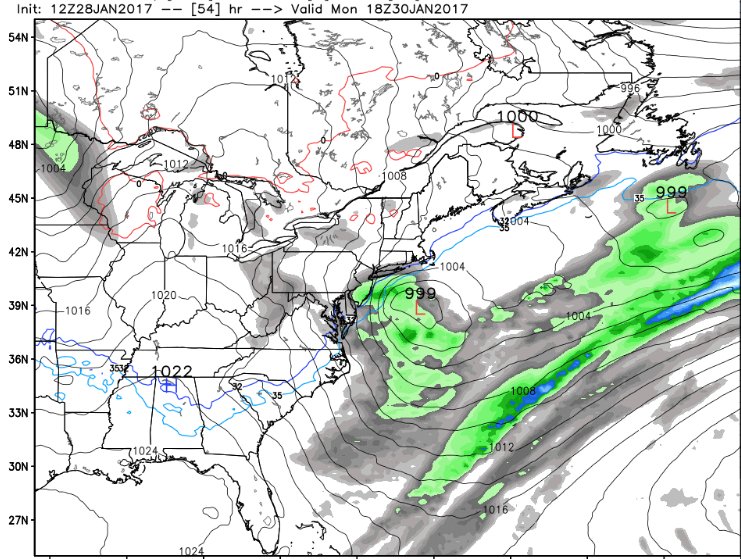
Still manages to cut near Pittsburgh then transfers to coastal just in time for most of us. Miller B setup. Taken this run verbatim, a little too close for comfort for me if you want a snowstorm.
nutleyblizzard- Senior Enthusiast
- Posts : 1952
Reputation : 41
Join date : 2014-01-30
Age : 58
Location : Nutley, new jersey
Re: Long Range Thread 13.0
![]() by Dunnzoo Sun Jan 29, 2017 11:39 am
by Dunnzoo Sun Jan 29, 2017 11:39 am


_________________
Janet
Snowfall winter of 2023-2024 17.5"
Snowfall winter of 2022-2023 6.0"
Snowfall winter of 2021-2022 17.6" 1" sleet 2/25/22
Snowfall winter of 2020-2021 51.1"
Snowfall winter of 2019-2020 8.5"
Snowfall winter of 2018-2019 25.1"
Snowfall winter of 2017-2018 51.9"
Snowfall winter of 2016-2017 45.6"
Snowfall winter of 2015-2016 29.5"
Snowfall winter of 2014-2015 50.55"
Snowfall winter of 2013-2014 66.5"
Dunnzoo- Senior Enthusiast - Mod
- Posts : 4886
Reputation : 68
Join date : 2013-01-11
Age : 62
Location : Westwood, NJ
Re: Long Range Thread 13.0
![]() by amugs Sun Jan 29, 2017 1:14 pm
by amugs Sun Jan 29, 2017 1:14 pm
EDIT : Armando just seeing your post (excellent write up) after I did this write up
.png)
_________________
Mugs
AKA:King: Snow Weenie
Self Proclaimed
WINTER 2014-15 : 55.12" +.02 for 6 coatings (avg. 35")
WINTER 2015-16 Total - 29.8" (Avg 35")
WINTER 2016-17 : 39.5" so far
amugs- Advanced Forecaster - Mod
- Posts : 15093
Reputation : 213
Join date : 2013-01-07
Age : 54
Location : Hillsdale,NJ
Re: Long Range Thread 13.0
![]() by amugs Sun Jan 29, 2017 2:45 pm
by amugs Sun Jan 29, 2017 2:45 pm
_________________
Mugs
AKA:King: Snow Weenie
Self Proclaimed
WINTER 2014-15 : 55.12" +.02 for 6 coatings (avg. 35")
WINTER 2015-16 Total - 29.8" (Avg 35")
WINTER 2016-17 : 39.5" so far
amugs- Advanced Forecaster - Mod
- Posts : 15093
Reputation : 213
Join date : 2013-01-07
Age : 54
Location : Hillsdale,NJ
Page 7 of 40 • 1 ... 6, 7, 8 ... 23 ... 40 ![]()
|
|
|