
 Search
BLOG: Roidzilla Could Impact Area Tuesday March 14th
Page 21 of 25 •  1 ... 12 ... 20, 21, 22, 23, 24, 25
 ![]()
Re: BLOG: Roidzilla Could Impact Area Tuesday March 14th
![]() by nutleyblizzard Sat Mar 11, 2017 6:42 am
by nutleyblizzard Sat Mar 11, 2017 6:42 am
nutleyblizzard- Senior Enthusiast

- Posts : 1952
Join date : 2014-01-30
Re: BLOG: Roidzilla Could Impact Area Tuesday March 14th
![]() by Guest Sat Mar 11, 2017 6:44 am
by Guest Sat Mar 11, 2017 6:44 am
Guest- Guest
Re: BLOG: Roidzilla Could Impact Area Tuesday March 14th
![]() by billg315 Sat Mar 11, 2017 6:44 am
by billg315 Sat Mar 11, 2017 6:44 am
Last edited by billg315 on Sat Mar 11, 2017 6:58 am; edited 1 time in total

billg315- Advanced Forecaster - Mod

- Posts : 4462
Reputation : 185
Join date : 2015-01-24
Age : 50
Location : Flemington, NJ
Re: BLOG: Roidzilla Could Impact Area Tuesday March 14th
![]() by skinsfan1177 Sat Mar 11, 2017 6:47 am
by skinsfan1177 Sat Mar 11, 2017 6:47 am
billg315 wrote:I've said it before and I'll repeat. The thing I worry about most is a last minute trend taking the storm too far off the coast, not it hugging the coast and mixing issues. Why? Just from my experience, and rules are made to be broken, but 1. When models are wrong for coastal systems they seem to jog EAST of initially projected path more than west; 2. I can count on one hand the times I've seen a Low Pressure center track right into NJ as opposed to offshore (maybe two hands - still rare). They want to stay offshore over water it seems; 3. Even if it really hugs the coast and sleet and rain mix in, it still starts and ends as snow in my estimation and I still think we get a foot even with mixing (1993 had major mixing issues and most areas got at least a foot). My nightmare is OTS we get flurries/ or an accelerated storm that ends in 10 hours cutting totals in half - not the "too close to the coast issue. If I'm wrong so be it.
I'm thinking a BM track or just inside it

skinsfan1177- Senior Enthusiast
- Posts : 4485
Reputation : 35
Join date : 2013-01-07
Age : 46
Location : Point Pleasant Boro
Re: BLOG: Roidzilla Could Impact Area Tuesday March 14th
![]() by docstox12 Sat Mar 11, 2017 6:49 am
by docstox12 Sat Mar 11, 2017 6:49 am
billg315 wrote:p.s. JMan should get his winds from this one. It has been ridiculously windy this March. If we don't get 30-40 mph winds from this neutron bomb sitting off the coast, I give up on wind forecasting.
Yep, Billg! What a parlay for the Jman!!! Heavy snow and wind!
Looking more this morning like an area wide snowstorm.Hope the pieces all come together right.As Doc always says...."WE TRACK!!!"NWS took the mix out for the northern coastal areas and mentions heavy snow for me .Already got me for 2 to 4 Monday night this far out!That's goota be a good sign.
Was 5 degrees here a little while ago, 68%, 29.83R. LOL, was out walkiing Tuesday in 60 degree sunshine and now I look at a windblown frozen snowpack!!!
Last edited by docstox12 on Sat Mar 11, 2017 6:52 am; edited 1 time in total

docstox12- Wx Statistician Guru

- Posts : 8502
Reputation : 222
Join date : 2013-01-07
Age : 73
Location : Monroe NY
Re: BLOG: Roidzilla Could Impact Area Tuesday March 14th
![]() by Radz Sat Mar 11, 2017 6:49 am
by Radz Sat Mar 11, 2017 6:49 am
Last edited by Radz on Sat Mar 11, 2017 6:57 am; edited 1 time in total (Reason for editing : Clarification)

Radz- Pro Enthusiast

- Posts : 1028
Reputation : 17
Join date : 2013-01-12
Location : Cortlandt Manor NY
Re: BLOG: Roidzilla Could Impact Area Tuesday March 14th
![]() by Radz Sat Mar 11, 2017 6:52 am
by Radz Sat Mar 11, 2017 6:52 am

Last edited by Radz on Sat Mar 11, 2017 7:02 am; edited 1 time in total (Reason for editing : better pic)
Radz- Pro Enthusiast
- Posts : 1028
Reputation : 17
Join date : 2013-01-12
Location : Cortlandt Manor NY
Re: BLOG: Roidzilla Could Impact Area Tuesday March 14th
![]() by track17 Sat Mar 11, 2017 6:53 am
by track17 Sat Mar 11, 2017 6:53 am
track17- Posts : 454
Reputation : 4
Join date : 2016-01-09
Re: BLOG: Roidzilla Could Impact Area Tuesday March 14th
![]() by track17 Sat Mar 11, 2017 6:53 am
by track17 Sat Mar 11, 2017 6:53 am
track17- Posts : 454
Reputation : 4
Join date : 2016-01-09
Re: BLOG: Roidzilla Could Impact Area Tuesday March 14th
![]() by nutleyblizzard Sat Mar 11, 2017 6:53 am
by nutleyblizzard Sat Mar 11, 2017 6:53 am
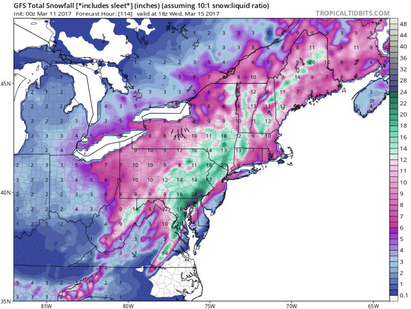
That's the 00z run snow map.Radz wrote:

nutleyblizzard- Senior Enthusiast
- Posts : 1952
Reputation : 41
Join date : 2014-01-30
Age : 58
Location : Nutley, new jersey
Re: BLOG: Roidzilla Could Impact Area Tuesday March 14th
![]() by jmanley32 Sat Mar 11, 2017 6:58 am
by jmanley32 Sat Mar 11, 2017 6:58 am

jmanley32- Senior Enthusiast
- Posts : 20513
Reputation : 108
Join date : 2013-12-12
Age : 42
Location : Yonkers, NY
Re: BLOG: Roidzilla Could Impact Area Tuesday March 14th
![]() by devsman Sat Mar 11, 2017 6:59 am
by devsman Sat Mar 11, 2017 6:59 am
billg315 wrote:I've said it before and I'll repeat. The thing I worry about most is a last minute trend taking the storm too far off the coast, not it hugging the coast and mixing issues. Why? Just from my experience, and rules are made to be broken, but 1. When models are wrong for coastal systems they seem to jog EAST of initially projected path more than west; 2. I can count on one hand the times I've seen a Low Pressure center track right into NJ as opposed to offshore (maybe two hands - still rare). They want to stay offshore over water it seems; 3. Even if it really hugs the coast and sleet and rain mix in, it still starts and ends as snow in my estimation and I still think we get a foot even with mixing (1993 had major mixing issues and most areas got at least a foot). My nightmare is OTS we get flurries/ or an accelerated storm that ends in 10 hours cutting totals in half - not the "too close to the coast issue. If I'm wrong so be it.
Bingo! This isn;t going up the coast. If it misses for us, it'e east of the BM. That has been the pattern for a few years now.

devsman- Pro Enthusiast
- Posts : 424
Reputation : 4
Join date : 2014-01-01
Age : 48
Location : merrick, ny (south shore of Long Island)
Re: BLOG: Roidzilla Could Impact Area Tuesday March 14th
![]() by Radz Sat Mar 11, 2017 7:04 am
by Radz Sat Mar 11, 2017 7:04 am
nutleyblizzard wrote:That's the 00z run snow map.Radz wrote:
Sorry, too many open windows, not enough sleep...
Radz- Pro Enthusiast
- Posts : 1028
Reputation : 17
Join date : 2013-01-12
Location : Cortlandt Manor NY
Re: BLOG: Roidzilla Could Impact Area Tuesday March 14th
![]() by Frank_Wx Sat Mar 11, 2017 7:08 am
by Frank_Wx Sat Mar 11, 2017 7:08 am
Models continue to strongly signal potential for a strong coastal
storm during the Monday Night into Tue Night period in response to
interaction between northern stream...Pac...and sub-tropical
energies across the Central and Southern US. Strength/location
differences still exists on how these energies phase...but they are
converging on the idea of PAC energy diving into the southern U.S
and phasing with subtropical energy Mon Night...with this phased
energy then tracking up the coast around digging northern stream
energy/developing Great Lakes upper low on Tuesday...and then
eventually phasing with the northern stream energy as a closed low
over NE US Tue Night/Wed. Note there are also a small subset of
solutions that leave PAC and subtropical energies
unphased...which would result in a split scenario of offshore
low and inside runner. In any case...expecting convergence on
solutions in the next 24-36 hrs as these discrete energies get
sampled by RAOB networks...but may still take till within 24 hrs
models to strongly converge based on the inherent model
difficulty in handling such as complex handing northern and
southern stream phasing.
This above spread manifests in more-so track and to a lesser extent
intensity/timing differences of resultant southern low tracking up
the coast Mon Night into Tue Night. Operational track spread exists
in how close to the coast low pressure hugs which are all in play at
this point, but for consistency and middle road have stayed close to
previous forecast and EPS/GEFS ensemble means with a low
pressure track off the Mid Atlantic...se of LI...and near Cape
Cod.
Based on above...potential for a widespread significant snowfall (1
ft+) combined with strong winds continues. With ECMWF/GFS
showing potential for 60kt+ at 950 HPA along the coastal
plain Tue/Tue eve...a threat for high wind gusts and blizzard
conditions exists.
Based on extent of southern stream phasing and resulting viable
model spread of low pressure tracks...potential for a period of
mixing or even a period of heavy rain continues along the coast.
Official forecast...heavily leaned towards EPS/GEFS ensemble
mean tracks...would limit any mixing to the south fork of LI.
Low pressure departs Tuesday Night with heavy precip ending...but
snow showers could lingers through Wednesday as the phased
and closed upper low moves through.
High pressure builds in thereafter.
Well below normal temperatures expected through the week.
_________________
_______________________________________________________________________________________________________
CLICK HERE to view NJ Strong Snowstorm Classifications

Frank_Wx- Godzilla Seeker

- Posts : 21305
Reputation : 328
Join date : 2013-01-05
Age : 31
Location : Jersey City, NJ -

Re: BLOG: Roidzilla Could Impact Area Tuesday March 14th
![]() by nutleyblizzard Sat Mar 11, 2017 7:13 am
by nutleyblizzard Sat Mar 11, 2017 7:13 am
nutleyblizzard- Senior Enthusiast
- Posts : 1952
Reputation : 41
Join date : 2014-01-30
Age : 58
Location : Nutley, new jersey
Re: BLOG: Roidzilla Could Impact Area Tuesday March 14th
![]() by sroc4 Sat Mar 11, 2017 7:18 am
by sroc4 Sat Mar 11, 2017 7:18 am

Confidence is HIGH that a powerful Nor' Easter will produce heavy snow, damaging winds, and significant coastal beach erosion affecting the east coast early next week. Timing for snow to start over LI will likely be between 12am and 6am Tuesday morning. For Long Island as well as the coastal plain from about I-95 South and East the question is do we measure snowfall in inches or feet? Yes this system has a max potential for 1-2 feet or more depending on the exact track. A track closer to the coast, yellow arrow, means the coast will likely see a change over from snow, to heavy rain, then back to snow limiting snow totals. A track further off the coast, red arrow, and the coast will stay all snow. Right now I am favoring a track just to the right of the middle of the two on the map provided which would bring the rain snow line somewhere right along the coast. Again there will likely be an axis of snow totals between 1-2ft +. Whether its along the coastal plain of just inland is track dependant. That will likely be nailed down more definitively by Sunday eve. A snow map will be posted Sunday eve or Monday morning. NOTE: the heaviest snowfall typically falls just north and west of the rain snow line, so they say you have to smell the rain to get the highest snow totals.
WE TRACK!!!!!

Last edited by sroc4 on Sat Mar 11, 2017 7:20 am; edited 2 times in total
_________________
"In weather and in life, there's no winning and losing; there's only winning and learning."
WINTER 2012/2013 TOTALS 43.65"WINTER 2017/2018 TOTALS 62.85" WINTER 2022/2023 TOTALS 4.9"
WINTER 2013/2014 TOTALS 64.85"WINTER 2018/2019 TOTALS 14.25" WINTER 2023/2024 TOTALS 13.1"
WINTER 2014/2015 TOTALS 71.20"WINTER 2019/2020 TOTALS 6.35"
WINTER 2015/2016 TOTALS 35.00"WINTER 2020/2021 TOTALS 37.75"
WINTER 2016/2017 TOTALS 42.25"WINTER 2021/2022 TOTALS 31.65"

sroc4- Admin
- Posts : 8331
Reputation : 301
Join date : 2013-01-07
Location : Wading River, LI
Re: BLOG: Roidzilla Could Impact Area Tuesday March 14th
![]() by jmanley32 Sat Mar 11, 2017 7:18 am
by jmanley32 Sat Mar 11, 2017 7:18 am
jmanley32- Senior Enthusiast
- Posts : 20513
Reputation : 108
Join date : 2013-12-12
Age : 42
Location : Yonkers, NY
Re: BLOG: Roidzilla Could Impact Area Tuesday March 14th
![]() by mikeypizano Sat Mar 11, 2017 7:19 am
by mikeypizano Sat Mar 11, 2017 7:19 am

mikeypizano- Pro Enthusiast
- Posts : 1118
Reputation : 66
Join date : 2017-01-05
Age : 35
Location : Wilkes-Barre/Scranton, PA
Re: BLOG: Roidzilla Could Impact Area Tuesday March 14th
![]() by jmanley32 Sat Mar 11, 2017 7:25 am
by jmanley32 Sat Mar 11, 2017 7:25 am
jmanley32- Senior Enthusiast
- Posts : 20513
Reputation : 108
Join date : 2013-12-12
Age : 42
Location : Yonkers, NY
Re: BLOG: Roidzilla Could Impact Area Tuesday March 14th
![]() by Grselig Sat Mar 11, 2017 7:25 am
by Grselig Sat Mar 11, 2017 7:25 am

Grselig- Senior Enthusiast
- Posts : 1408
Reputation : 140
Join date : 2013-03-04
Age : 54
Location : Wayne NJ
Re: BLOG: Roidzilla Could Impact Area Tuesday March 14th
![]() by nutleyblizzard Sat Mar 11, 2017 7:27 am
by nutleyblizzard Sat Mar 11, 2017 7:27 am

GEFS ARE GORGEOUS!!!
nutleyblizzard- Senior Enthusiast
- Posts : 1952
Reputation : 41
Join date : 2014-01-30
Age : 58
Location : Nutley, new jersey
Re: BLOG: Roidzilla Could Impact Area Tuesday March 14th
![]() by jmanley32 Sat Mar 11, 2017 7:28 am
by jmanley32 Sat Mar 11, 2017 7:28 am
do u really think with Franks level of excitement and confidence that that all rsin or ots is sn issue? This storm is coming no doubt and I am nodding towards all or nearly all snow as are many mets.Grselig wrote:I keep on waiting for the shoe to fall and we get rain or nothing. But based on last nights Euro and NWS diso etc it seems like the laces are tightening. Amazing.
jmanley32- Senior Enthusiast
- Posts : 20513
Reputation : 108
Join date : 2013-12-12
Age : 42
Location : Yonkers, NY
Re: BLOG: Roidzilla Could Impact Area Tuesday March 14th
![]() by jmanley32 Sat Mar 11, 2017 7:31 am
by jmanley32 Sat Mar 11, 2017 7:31 am
agreed I'm leaning more towards late tomorrow for that just knowing frank wants to b sure. Which is smart don't want call roid too early.nutleyblizzard wrote:Looks like we are starting to get a consensus on a track. If we hold serve with the upcoming 12z suite, or dare I say trend better, I would think Frank upgrades to Roidzilla storm mode status.
jmanley32- Senior Enthusiast
- Posts : 20513
Reputation : 108
Join date : 2013-12-12
Age : 42
Location : Yonkers, NY
Re: BLOG: Roidzilla Could Impact Area Tuesday March 14th
![]() by Frank_Wx Sat Mar 11, 2017 7:36 am
by Frank_Wx Sat Mar 11, 2017 7:36 am

_________________
_______________________________________________________________________________________________________
CLICK HERE to view NJ Strong Snowstorm Classifications
Frank_Wx- Godzilla Seeker
- Posts : 21305
Reputation : 328
Join date : 2013-01-05
Age : 31
Location : Jersey City, NJ -
Re: BLOG: Roidzilla Could Impact Area Tuesday March 14th
![]() by nutleyblizzard Sat Mar 11, 2017 7:38 am
by nutleyblizzard Sat Mar 11, 2017 7:38 am
I also have that same fear too JMan. Most of us lived through that god awful heartbreak with March 2001 when models were in agreement inside 3 days for a historic event only to fail miserably. That event has taught me too temper my expectations with any snow threat. As each model run commences and we get closer to the event, the tension will rise. Today's 12z suite and more so tonights 00Z runs will be unbearable. In my opinion, if we are able to hold serve by Sunday's 12z suite, we will be good to go.jmanley32 wrote:do u really think with Franks level of excitement and confidence tgat tgat is a issue? This storm is coming no dpubt and I am nodding towars all or nearly all snow as are many mets.Grselig wrote:I keep on waiting for the shoe to fall and we get rain or nothing. But based on last nights Euro and NWS diso etc it seems like the laces are tightening. Amazing.
nutleyblizzard- Senior Enthusiast
- Posts : 1952
Reputation : 41
Join date : 2014-01-30
Age : 58
Location : Nutley, new jersey
Re: BLOG: Roidzilla Could Impact Area Tuesday March 14th
![]() by sroc4 Sat Mar 11, 2017 7:45 am
by sroc4 Sat Mar 11, 2017 7:45 am
nutleyblizzard wrote:I also have that same fear too JMan. Most of us lived through that god awful heartbreak with March 2001 when models were in agreement inside 3 days for a historic event only to fail miserably. That event has taught me too temper my expectations with any snow threat. As each model run commences and we get closer to the event, the tension will rise. Today's 12z suite and more so tonights 00Z runs will be unbearable. In my opinion, if we are able to hold serve by Sunday's 12z suite, we will be good to go.jmanley32 wrote:do u really think with Franks level of excitement and confidence tgat tgat is a issue? This storm is coming no dpubt and I am nodding towars all or nearly all snow as are many mets.Grselig wrote:I keep on waiting for the shoe to fall and we get rain or nothing. But based on last nights Euro and NWS diso etc it seems like the laces are tightening. Amazing.
The Pacific energy will not be fully onshore until 00z and 06z Sunday. Same with the polar energy and the energy in the STJ. If we are going to see the late trends in the models its between now and 12z tomorrow. Eggs shells for sure. Its no longer a matter of if, but rather, how much.
_________________
"In weather and in life, there's no winning and losing; there's only winning and learning."
WINTER 2012/2013 TOTALS 43.65"WINTER 2017/2018 TOTALS 62.85" WINTER 2022/2023 TOTALS 4.9"
WINTER 2013/2014 TOTALS 64.85"WINTER 2018/2019 TOTALS 14.25" WINTER 2023/2024 TOTALS 13.1"
WINTER 2014/2015 TOTALS 71.20"WINTER 2019/2020 TOTALS 6.35"
WINTER 2015/2016 TOTALS 35.00"WINTER 2020/2021 TOTALS 37.75"
WINTER 2016/2017 TOTALS 42.25"WINTER 2021/2022 TOTALS 31.65"
sroc4- Admin
- Posts : 8331
Reputation : 301
Join date : 2013-01-07
Location : Wading River, LI
Re: BLOG: Roidzilla Could Impact Area Tuesday March 14th
![]() by Grselig Sat Mar 11, 2017 7:49 am
by Grselig Sat Mar 11, 2017 7:49 am
jmanley32 wrote:do u really think with Franks level of excitement and confidence that that all rsin or ots is sn issue? This storm is coming no doubt and I am nodding towards all or nearly all snow as are many mets.Grselig wrote:I keep on waiting for the shoe to fall and we get rain or nothing. But based on last nights Euro and NWS diso etc it seems like the laces are tightening. Amazing.
It defies logic but as others have said, we've all been burned in the past. We've been tracking this a week out and things sometimes disappear (AND COME BACK STRONG). A deal is never done till its done. I don't think I have ever seen Frank and other very very knowledgabe this confident about a storm at this stage in the game. Yes, its eggshells until it happens!!
Last edited by Grselig on Sat Mar 11, 2017 7:53 am; edited 1 time in total
Grselig- Senior Enthusiast
- Posts : 1408
Reputation : 140
Join date : 2013-03-04
Age : 54
Location : Wayne NJ
Page 21 of 25 • 1 ... 12 ... 20, 21, 22, 23, 24, 25 ![]()
|
|
|