
 Search
Tracking Hurricane Irma
Page 12 of 35 •  1 ... 7 ... 11, 12, 13 ... 23 ... 35
 ![]()
weatherwatchermom- Senior Enthusiast

- Posts : 3749
Join date : 2014-11-25
Re: Tracking Hurricane Irma
![]() by Guest Sun Sep 03, 2017 1:04 am
by Guest Sun Sep 03, 2017 1:04 am
Guest- Guest
Re: Tracking Hurricane Irma
![]() by Math23x7 Sun Sep 03, 2017 3:07 am
by Math23x7 Sun Sep 03, 2017 3:07 am
1) It trended slightly closer to Puerto Rico. If it goes through PR, it will disrupt the development of Irma to say the least.
2) I need to see the EURO ensemble guidance. That tells the full story. I will not be staying up for that so I'll find out later this morning.
Night all.
Math23x7- Wx Statistician Guru

- Posts : 2379
Reputation : 68
Join date : 2013-01-08

Snow88- Senior Enthusiast
- Posts : 2193
Reputation : 4
Join date : 2013-01-09
Age : 35
Location : Brooklyn, NY
Re: Tracking Hurricane Irma
![]() by amugs Sun Sep 03, 2017 8:18 am
by amugs Sun Sep 03, 2017 8:18 am
Remember tjis hcanes that strike up here don't like heat ridges and cool patterns.
Lots of time to go here.
Model mayhem continues.
_________________
Mugs
AKA:King: Snow Weenie
Self Proclaimed
WINTER 2014-15 : 55.12" +.02 for 6 coatings (avg. 35")
WINTER 2015-16 Total - 29.8" (Avg 35")
WINTER 2016-17 : 39.5" so far

amugs- Advanced Forecaster - Mod

- Posts : 15093
Reputation : 213
Join date : 2013-01-07
Age : 54
Location : Hillsdale,NJ
Re: Tracking Hurricane Irma
![]() by sroc4 Sun Sep 03, 2017 8:38 am
by sroc4 Sun Sep 03, 2017 8:38 am
First off the track of Irma is getting very consistent between days 3-6. There is still time for fluctuations however, but look at the side by side comparisons regarding Irma as she approaches the Northern Lesser Antilles. The trend on the GFS has slowly been to shift the track closer and closer to the N Islands. The euro is only a facrtion faster and further S and W then the GFS but not by much. It looks more and more likely that they will be impacted with at least trop storm force winds; however, a shift in the track north or south by as little as 50miles or so could be the difference between a significant impact vs minor to no impact. If you know anyone in this region please tell them to prepare now. I lived on the Island of St Kitts for a little over 2 yrs so I have particular concern for that little rock as they look to be impacted by Irma's in some fashion at this time. Any shift south in the track and those impacts could be significant.
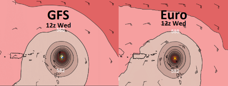
Looking out a little further, fast forward to 00z Saturday. You can see by the side by side both models have Irmas center in close proximity of one another in or just north of the Bahamas. While the euro has been pretty consistent with a track near here, the GFS as little as yesterdays 6z, 12z and 18z Had Irma MUCH farther N by this time frame:
BUT overnight 00z and this mornings 06z have significantly shifted the center south towards the euro soln. We will see if today this holds serve as this will be very important for reasons explained in image above and images below. I used a yellow dot to show you where the other models respective center is so you can see that just as with the Northern Lesser Antilles a shift of the track by as little as 25-50miles N or S could have HUGE impacts on the Bahaman islands as well.

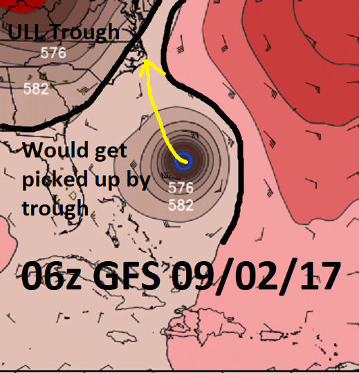
Now lets zoom out a bit. Remaining at 00z Sat or day 6, you can see a lot is going on on the maps below. Here are the key points that I found to be common amongst both GFS and Euro Ops as well as their respective ensemble means as of last nights 0z runs. Let me be very clear here. I do not believe we have seen the final soln at both H5 or the surface so be patient.
It appears that the main trough lifts into the Mid Atlantic/NE and cuts off from the main flow and develops as an ULL. At the same time as this is happening notice there is additional energy hanging back over the N plains states indicated by the circle with the black X in it and an anomalous ridge building over top in central Canada. The ULL in the NE is a trough split, but instead of backing up W and forcing Irma in between it and the WAR like the GFS showed a day or two ago......................:
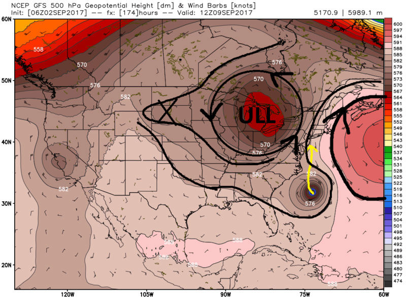
..............Irma misses this particular connection like the 06 z images from yesterday indicated, as it is now modeled much further south at this time frame.
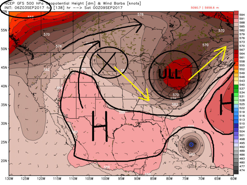
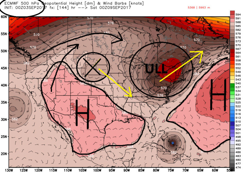
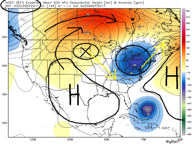
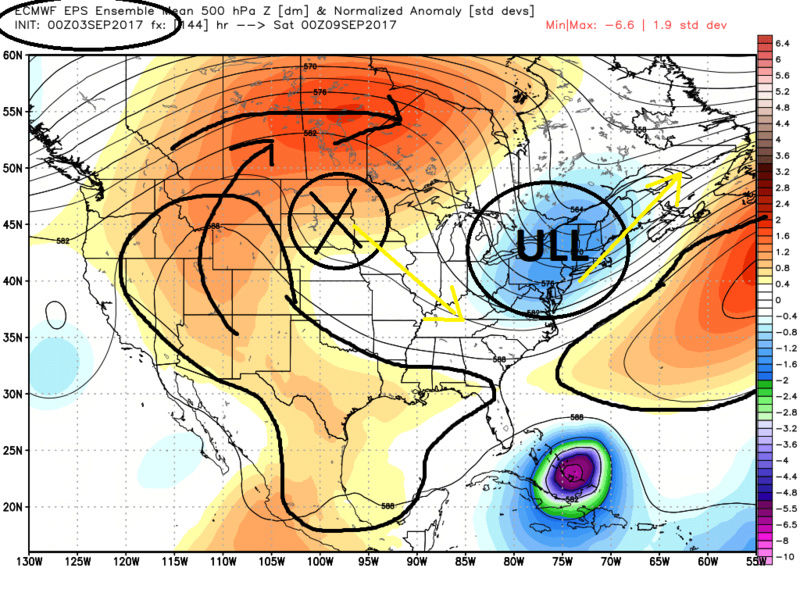
As we move forward in time there is an anomalous Ridge in central Canada that comes over the top of the energy I have labeled X forcing it south East. This is called a wave break when a ridge comes over the top of a trough like this, and is a particularly complex situation for models to get right esp in the long term. But in essence what this wave break does is kicks the ULL out and force the energy X SE such that a ridge bridge wants to form between the WAR and the ridge over Canada. This traps Irma from escaping OTS. Its then the energy labeled X that eventually captures Irma and pulls it into the coast.
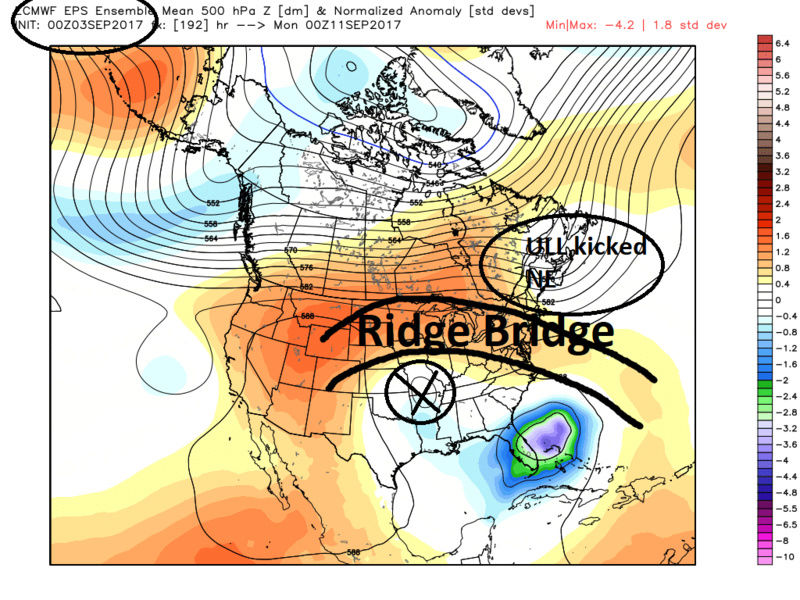
Keep in mind everything above is as is depicted in the modeling over night and may and likely will cont to evolve some, but its the first time I have seen decent agreement. I want to see how today and tonight's models runs go before I lock in the general set up. Once that's locked in then the details of where the landfall cone will be can be worked on.
Track Fla into GOM= 5%
Track OTS = 10%
Track central Fla to OBX = 50%
Track OBX to S NE = 35%
Last edited by sroc4 on Sun Sep 03, 2017 9:06 am; edited 4 times in total
_________________
"In weather and in life, there's no winning and losing; there's only winning and learning."
WINTER 2012/2013 TOTALS 43.65"WINTER 2017/2018 TOTALS 62.85" WINTER 2022/2023 TOTALS 4.9"
WINTER 2013/2014 TOTALS 64.85"WINTER 2018/2019 TOTALS 14.25" WINTER 2023/2024 TOTALS 13.1"
WINTER 2014/2015 TOTALS 71.20"WINTER 2019/2020 TOTALS 6.35"
WINTER 2015/2016 TOTALS 35.00"WINTER 2020/2021 TOTALS 37.75"
WINTER 2016/2017 TOTALS 42.25"WINTER 2021/2022 TOTALS 31.65"

sroc4- Admin

- Posts : 8331
Reputation : 301
Join date : 2013-01-07
Location : Wading River, LI
Re: Tracking Hurricane Irma
![]() by Dunnzoo Sun Sep 03, 2017 8:50 am
by Dunnzoo Sun Sep 03, 2017 8:50 am
_________________
Janet
Snowfall winter of 2023-2024 17.5"
Snowfall winter of 2022-2023 6.0"
Snowfall winter of 2021-2022 17.6" 1" sleet 2/25/22
Snowfall winter of 2020-2021 51.1"
Snowfall winter of 2019-2020 8.5"
Snowfall winter of 2018-2019 25.1"
Snowfall winter of 2017-2018 51.9"
Snowfall winter of 2016-2017 45.6"
Snowfall winter of 2015-2016 29.5"
Snowfall winter of 2014-2015 50.55"
Snowfall winter of 2013-2014 66.5"

Dunnzoo- Senior Enthusiast - Mod
- Posts : 4891
Reputation : 68
Join date : 2013-01-11
Age : 62
Location : Westwood, NJ

jake732- Pro Enthusiast

- Posts : 449
Reputation : 0
Join date : 2016-01-03
Location : lakewood, nj -

Re: Tracking Hurricane Irma
![]() by sroc4 Sun Sep 03, 2017 9:04 am
by sroc4 Sun Sep 03, 2017 9:04 am
jake732 wrote:What's OBX?
Outer Banks
_________________
"In weather and in life, there's no winning and losing; there's only winning and learning."
WINTER 2012/2013 TOTALS 43.65"WINTER 2017/2018 TOTALS 62.85" WINTER 2022/2023 TOTALS 4.9"
WINTER 2013/2014 TOTALS 64.85"WINTER 2018/2019 TOTALS 14.25" WINTER 2023/2024 TOTALS 13.1"
WINTER 2014/2015 TOTALS 71.20"WINTER 2019/2020 TOTALS 6.35"
WINTER 2015/2016 TOTALS 35.00"WINTER 2020/2021 TOTALS 37.75"
WINTER 2016/2017 TOTALS 42.25"WINTER 2021/2022 TOTALS 31.65"
sroc4- Admin
- Posts : 8331
Reputation : 301
Join date : 2013-01-07
Location : Wading River, LI
Re: Tracking Hurricane Irma
![]() by nutleyblizzard Sun Sep 03, 2017 9:06 am
by nutleyblizzard Sun Sep 03, 2017 9:06 am

nutleyblizzard- Senior Enthusiast
- Posts : 1952
Reputation : 41
Join date : 2014-01-30
Age : 58
Location : Nutley, new jersey
Re: Tracking Hurricane Irma
![]() by nutleyblizzard Sun Sep 03, 2017 9:18 am
by nutleyblizzard Sun Sep 03, 2017 9:18 am
My good neighbors are in the process of selling their home. They made plans to rent a house down in the outer banks of NC on September 9th to look for homes. I told them yesterday to keep tabs on the latest forecast. The overnight model runs are not encouraging. Talk about bad timing.sroc4 wrote:jake732 wrote:What's OBX?
Outer Banks
nutleyblizzard- Senior Enthusiast
- Posts : 1952
Reputation : 41
Join date : 2014-01-30
Age : 58
Location : Nutley, new jersey
Re: Tracking Hurricane Irma
![]() by weatherwatchermom Sun Sep 03, 2017 10:15 am
by weatherwatchermom Sun Sep 03, 2017 10:15 am

weatherwatchermom- Senior Enthusiast
- Posts : 3749
Reputation : 77
Join date : 2014-11-25
Age : 60
Location : Hazlet Township, NJ
Re: Tracking Hurricane Irma
![]() by weatherwatchermom Sun Sep 03, 2017 10:16 am
by weatherwatchermom Sun Sep 03, 2017 10:16 am
I have ties to Beaufort (bouge sound)area and that's where my parents are buying a house...nutleyblizzard wrote:My good neighbors are in the process of selling their home. They made plans to rent a house down in the outer banks of NC on September 9th to look for homes. I told them yesterday to keep tabs on the latest forecast. The overnight model runs are not encouraging. Talk about bad timing.sroc4 wrote:jake732 wrote:What's OBX?
Outer Banks

weatherwatchermom- Senior Enthusiast
- Posts : 3749
Reputation : 77
Join date : 2014-11-25
Age : 60
Location : Hazlet Township, NJ
Re: Tracking Hurricane Irma
![]() by docstox12 Sun Sep 03, 2017 10:19 am
by docstox12 Sun Sep 03, 2017 10:19 am

docstox12- Wx Statistician Guru
- Posts : 8506
Reputation : 222
Join date : 2013-01-07
Age : 73
Location : Monroe NY
Re: Tracking Hurricane Irma
![]() by jimv45 Sun Sep 03, 2017 10:22 am
by jimv45 Sun Sep 03, 2017 10:22 am
jimv45- Senior Enthusiast
- Posts : 1168
Reputation : 36
Join date : 2013-09-20
Location : Hopewell jct.
Re: Tracking Hurricane Irma
![]() by mikeypizano Sun Sep 03, 2017 10:56 am
by mikeypizano Sun Sep 03, 2017 10:56 am
docstox12 wrote:I am still hoping for an OTS solution.As much as I hate to see any area of the USA impacted by this storm, I am glad the trend is to keep the worst impacts to the south of us.I realize its still very early, but it is encouraging for our area.
If it makes any difference, I will be prepared for the worst, which means there is a good chance that this storm will go out to sea! If its anything like snow, when I get the snow blower ready, we get nothing, so I am going to go all out for this one!

mikeypizano- Pro Enthusiast
- Posts : 1118
Reputation : 66
Join date : 2017-01-05
Age : 35
Location : Wilkes-Barre/Scranton, PA
Re: Tracking Hurricane Irma
![]() by jake732 Sun Sep 03, 2017 11:04 am
by jake732 Sun Sep 03, 2017 11:04 am
jake732- Pro Enthusiast
- Posts : 449
Reputation : 0
Join date : 2016-01-03
Location : lakewood, nj -
Re: Tracking Hurricane Irma
![]() by track17 Sun Sep 03, 2017 11:07 am
by track17 Sun Sep 03, 2017 11:07 am
track17- Posts : 454
Reputation : 4
Join date : 2016-01-09
jake732- Pro Enthusiast
- Posts : 449
Reputation : 0
Join date : 2016-01-03
Location : lakewood, nj -
Re: Tracking Hurricane Irma
![]() by jake732 Sun Sep 03, 2017 11:08 am
by jake732 Sun Sep 03, 2017 11:08 am
jake732- Pro Enthusiast
- Posts : 449
Reputation : 0
Join date : 2016-01-03
Location : lakewood, nj -
Re: Tracking Hurricane Irma
![]() by Frank_Wx Sun Sep 03, 2017 11:40 am
by Frank_Wx Sun Sep 03, 2017 11:40 am

_________________
_______________________________________________________________________________________________________
CLICK HERE to view NJ Strong Snowstorm Classifications

Frank_Wx- Godzilla Seeker
- Posts : 21305
Reputation : 328
Join date : 2013-01-05
Age : 31
Location : Jersey City, NJ -
Re: Tracking Hurricane Irma
![]() by amugs Sun Sep 03, 2017 12:14 pm
by amugs Sun Sep 03, 2017 12:14 pm
Track you can not make this statement at this time - many ENS members show crushing blows into our area. I am not rooting for this but OP models are to much in a state of flux and will be. We need better sampling of the PAC energy and the NA block that is going to form. Euro has its biases moving the ULL out too fast while it breaks down the WAR fast as well and GFS speeds things up and SE bias of coastals.track17 wrote:I disagree jake it is good to know we are in the clear with these trends.
When I look ta the pattern and I see a mod typhoon recurving into the GOA, where this set ups is crucial to what happens downstream, I don't give a rats behind what people wish for or want it's just what will drive the pattern. If it sets up correctly it will pump the PNA and NA Block where the ULL cuts off and gets trapped underneath. We have a Scandinavian block with a big ULL over western Europe that is blocking that side of the world up. This is not a microcosmic type of set up here but a global one that is VERY CONCERNING to me.
Isotherm posted on another board and has been adamant from a week ago. Landfall %
45% chance of North Carolina landfall; 15% chance of South Carolina landfall; and, 25% chance of a Virginia northward landfall
Last edited by amugs on Sun Sep 03, 2017 12:16 pm; edited 1 time in total
_________________
Mugs
AKA:King: Snow Weenie
Self Proclaimed
WINTER 2014-15 : 55.12" +.02 for 6 coatings (avg. 35")
WINTER 2015-16 Total - 29.8" (Avg 35")
WINTER 2016-17 : 39.5" so far
amugs- Advanced Forecaster - Mod
- Posts : 15093
Reputation : 213
Join date : 2013-01-07
Age : 54
Location : Hillsdale,NJ
Re: Tracking Hurricane Irma
![]() by aiannone Sun Sep 03, 2017 12:15 pm
by aiannone Sun Sep 03, 2017 12:15 pm
_________________
-Alex Iannone-

aiannone- Senior Enthusiast - Mod
- Posts : 4814
Reputation : 92
Join date : 2013-01-07
Location : Saint James, LI (Northwest Suffolk Co.)
Re: Tracking Hurricane Irma
![]() by Guest Sun Sep 03, 2017 12:17 pm
by Guest Sun Sep 03, 2017 12:17 pm
Last edited by TheAresian on Sun Sep 03, 2017 12:18 pm; edited 1 time in total (Reason for editing : Meant NOT to feel.)
Guest- Guest
Re: Tracking Hurricane Irma
![]() by amugs Sun Sep 03, 2017 12:17 pm
by amugs Sun Sep 03, 2017 12:17 pm
aiannone wrote:Say goodbye to the bahamas for years if this run plays out lol
Alex they are under the gun no matter what IMO.
_________________
Mugs
AKA:King: Snow Weenie
Self Proclaimed
WINTER 2014-15 : 55.12" +.02 for 6 coatings (avg. 35")
WINTER 2015-16 Total - 29.8" (Avg 35")
WINTER 2016-17 : 39.5" so far
amugs- Advanced Forecaster - Mod
- Posts : 15093
Reputation : 213
Join date : 2013-01-07
Age : 54
Location : Hillsdale,NJ
Re: Tracking Hurricane Irma
![]() by aiannone Sun Sep 03, 2017 12:19 pm
by aiannone Sun Sep 03, 2017 12:19 pm
amugs wrote:aiannone wrote:Say goodbye to the bahamas for years if this run plays out lol
Alex they are under the gun no matter what IMO.
Agreed, they will have some impacts regardless of what model wins out. It's just whether it's severe damage or complete destruction from a direct hit.
_________________
-Alex Iannone-
aiannone- Senior Enthusiast - Mod
- Posts : 4814
Reputation : 92
Join date : 2013-01-07
Location : Saint James, LI (Northwest Suffolk Co.)
Re: Tracking Hurricane Irma
![]() by aiannone Sun Sep 03, 2017 12:20 pm
by aiannone Sun Sep 03, 2017 12:20 pm
_________________
-Alex Iannone-
aiannone- Senior Enthusiast - Mod
- Posts : 4814
Reputation : 92
Join date : 2013-01-07
Location : Saint James, LI (Northwest Suffolk Co.)
Page 12 of 35 • 1 ... 7 ... 11, 12, 13 ... 23 ... 35 ![]()
|
|
|