
 Search
Long Range Thread 15.0
Page 13 of 42 •  1 ... 8 ... 12, 13, 14 ... 27 ... 42
 ![]()
Re: Long Range Thread 15.0
![]() by algae888 Wed Nov 29, 2017 6:06 pm
by algae888 Wed Nov 29, 2017 6:06 pm
RB I would be more concerned about suppression if we were in a El Nino Base state. All the years that I can remember during la nina when blocking showed up we had good Winters with that said the Base State that we're in now La Nina should keep some semblance of a South East Ridge so suppression would be the least of my concerns nowrb924119 wrote:Al, I could not agree more with your comment about the biggest potential occurring as the pattern would relax/reload. Mikey, correct me if I'm wrong, but I think a disproportionate amount of our big storms have come at the ends of these types of patterns, especially in recent years. But I also really like the front end this time; very different setup than what we usually have.
algae888- Advanced Forecaster

- Posts : 5311
Join date : 2013-02-05
Re: Long Range Thread 15.0
![]() by Frank_Wx Wed Nov 29, 2017 6:25 pm
by Frank_Wx Wed Nov 29, 2017 6:25 pm

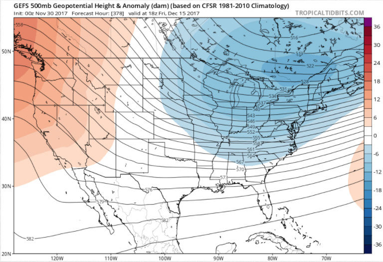
The EURO Ensembles show similar. Cold, cold, and more cold. This is out to December 9th.


Question becomes will snow accompany the cold. Answer is...yes.
Someone is going to see their first accumulating snow between the December 7th and December 20th time frame. Hopefully that is everyone on this board and not just N&W, or S&E, or way up north people.
The first storm threat is on December 8th, plus or minus 2 days. The GFS is sheering out the southern energy but the EURO tries to cook something up. By this point in time, the cold air will be in place.

A more detailed blog will follow this weekend if things continue looking as great as they do now.

Frank_Wx- Godzilla Seeker

- Posts : 21305
Join date : 2013-01-05 -

Re: Long Range Thread 15.0
![]() by Snow88 Wed Nov 29, 2017 6:31 pm
by Snow88 Wed Nov 29, 2017 6:31 pm

Snow88- Senior Enthusiast

- Posts : 2193
Reputation : 4
Join date : 2013-01-09
Age : 35
Location : Brooklyn, NY
Re: Long Range Thread 15.0
![]() by billg315 Wed Nov 29, 2017 7:17 pm
by billg315 Wed Nov 29, 2017 7:17 pm

billg315- Advanced Forecaster - Mod

- Posts : 4462
Reputation : 185
Join date : 2015-01-24
Age : 50
Location : Flemington, NJ
Re: Long Range Thread 15.0
![]() by Math23x7 Wed Nov 29, 2017 11:20 pm
by Math23x7 Wed Nov 29, 2017 11:20 pm

Let's just hope that the period from December 6th to 14th produces some snow for the region.
Also, Algae888, I addressed your comment in the Banter thread.
Math23x7- Wx Statistician Guru

- Posts : 2379
Reputation : 68
Join date : 2013-01-08
Re: Long Range Thread 15.0
![]() by Math23x7 Thu Nov 30, 2017 12:55 am
by Math23x7 Thu Nov 30, 2017 12:55 am
Math23x7- Wx Statistician Guru
- Posts : 2379
Reputation : 68
Join date : 2013-01-08
Re: Long Range Thread 15.0
![]() by Frank_Wx Thu Nov 30, 2017 6:01 am
by Frank_Wx Thu Nov 30, 2017 6:01 am
_________________
_______________________________________________________________________________________________________
CLICK HERE to view NJ Strong Snowstorm Classifications

Frank_Wx- Godzilla Seeker
- Posts : 21305
Reputation : 328
Join date : 2013-01-05
Age : 31
Location : Jersey City, NJ -
Re: Long Range Thread 15.0
![]() by docstox12 Thu Nov 30, 2017 7:01 am
by docstox12 Thu Nov 30, 2017 7:01 am

docstox12- Wx Statistician Guru
- Posts : 8501
Reputation : 222
Join date : 2013-01-07
Age : 73
Location : Monroe NY
Re: Long Range Thread 15.0
![]() by sroc4 Thu Nov 30, 2017 7:09 am
by sroc4 Thu Nov 30, 2017 7:09 am
_________________
"In weather and in life, there's no winning and losing; there's only winning and learning."
WINTER 2012/2013 TOTALS 43.65"WINTER 2017/2018 TOTALS 62.85" WINTER 2022/2023 TOTALS 4.9"
WINTER 2013/2014 TOTALS 64.85"WINTER 2018/2019 TOTALS 14.25" WINTER 2023/2024 TOTALS 13.1"
WINTER 2014/2015 TOTALS 71.20"WINTER 2019/2020 TOTALS 6.35"
WINTER 2015/2016 TOTALS 35.00"WINTER 2020/2021 TOTALS 37.75"
WINTER 2016/2017 TOTALS 42.25"WINTER 2021/2022 TOTALS 31.65"

sroc4- Admin
- Posts : 8331
Reputation : 301
Join date : 2013-01-07
Location : Wading River, LI
Re: Long Range Thread 15.0
![]() by Frank_Wx Thu Nov 30, 2017 8:10 am
by Frank_Wx Thu Nov 30, 2017 8:10 am

_________________
_______________________________________________________________________________________________________
CLICK HERE to view NJ Strong Snowstorm Classifications
Frank_Wx- Godzilla Seeker
- Posts : 21305
Reputation : 328
Join date : 2013-01-05
Age : 31
Location : Jersey City, NJ -
Re: Long Range Thread 15.0
![]() by algae888 Thu Nov 30, 2017 11:37 am
by algae888 Thu Nov 30, 2017 11:37 am

algae888- Advanced Forecaster
- Posts : 5311
Reputation : 46
Join date : 2013-02-05
Age : 61
Location : mt. vernon, new york
Re: Long Range Thread 15.0
![]() by amugs Thu Nov 30, 2017 12:04 pm
by amugs Thu Nov 30, 2017 12:04 pm

We have East Mounatin Torque influence from the Asian continent that will help protract the PAC JEt and cause it to buckle this allowing teh zonal flow to slow down which will promote storms on the mainland - thus in turn we have a recurring typhoon that may rival Nuri as projected - what you need to understand is that this beast as modeled will pump the PNA Ridge on teh West Coast big time and send these heights and heat up into teh arctic which will reach teh other side of teh world into Russia giving us a N AO and NAO into Greenland. The EPO region will go N to a 2.5 SD to maybe 3 if models are handling this correctly at this stage. We have low frequency and low AAM in the PAC that is going to interfere with the pattern as well
Interference in the PAC with the blue colors
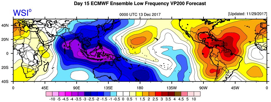
Recurving Typhoon

_________________
Mugs
AKA:King: Snow Weenie
Self Proclaimed
WINTER 2014-15 : 55.12" +.02 for 6 coatings (avg. 35")
WINTER 2015-16 Total - 29.8" (Avg 35")
WINTER 2016-17 : 39.5" so far

amugs- Advanced Forecaster - Mod
- Posts : 15093
Reputation : 213
Join date : 2013-01-07
Age : 54
Location : Hillsdale,NJ
Re: Long Range Thread 15.0
![]() by Frank_Wx Thu Nov 30, 2017 1:44 pm
by Frank_Wx Thu Nov 30, 2017 1:44 pm
_________________
_______________________________________________________________________________________________________
CLICK HERE to view NJ Strong Snowstorm Classifications
Frank_Wx- Godzilla Seeker
- Posts : 21305
Reputation : 328
Join date : 2013-01-05
Age : 31
Location : Jersey City, NJ -
Re: Long Range Thread 15.0
![]() by nutleyblizzard Thu Nov 30, 2017 1:48 pm
by nutleyblizzard Thu Nov 30, 2017 1:48 pm
The EURO day 8 500mb map just screams potential.Frank_Wx wrote:The EURO was very close to having a storm next Friday. All the pieces are there. An interesting week of tracking coming up. Our first event of the season

nutleyblizzard- Senior Enthusiast
- Posts : 1952
Reputation : 41
Join date : 2014-01-30
Age : 58
Location : Nutley, new jersey
Re: Long Range Thread 15.0
![]() by algae888 Thu Nov 30, 2017 2:02 pm
by algae888 Thu Nov 30, 2017 2:02 pm
Blocking in a La Nina and it's game on just go back and check the years that had such featuresnutleyblizzard wrote:The EURO day 8 500mb map just screams potential.Frank_Wx wrote:The EURO was very close to having a storm next Friday. All the pieces are there. An interesting week of tracking coming up. Our first event of the season
algae888- Advanced Forecaster
- Posts : 5311
Reputation : 46
Join date : 2013-02-05
Age : 61
Location : mt. vernon, new york
Re: Long Range Thread 15.0
![]() by sroc4 Thu Nov 30, 2017 2:21 pm
by sroc4 Thu Nov 30, 2017 2:21 pm
_________________
"In weather and in life, there's no winning and losing; there's only winning and learning."
WINTER 2012/2013 TOTALS 43.65"WINTER 2017/2018 TOTALS 62.85" WINTER 2022/2023 TOTALS 4.9"
WINTER 2013/2014 TOTALS 64.85"WINTER 2018/2019 TOTALS 14.25" WINTER 2023/2024 TOTALS 13.1"
WINTER 2014/2015 TOTALS 71.20"WINTER 2019/2020 TOTALS 6.35"
WINTER 2015/2016 TOTALS 35.00"WINTER 2020/2021 TOTALS 37.75"
WINTER 2016/2017 TOTALS 42.25"WINTER 2021/2022 TOTALS 31.65"
sroc4- Admin
- Posts : 8331
Reputation : 301
Join date : 2013-01-07
Location : Wading River, LI
Re: Long Range Thread 15.0
![]() by Dunnzoo Thu Nov 30, 2017 4:45 pm
by Dunnzoo Thu Nov 30, 2017 4:45 pm
_________________
Janet
Snowfall winter of 2023-2024 17.5"
Snowfall winter of 2022-2023 6.0"
Snowfall winter of 2021-2022 17.6" 1" sleet 2/25/22
Snowfall winter of 2020-2021 51.1"
Snowfall winter of 2019-2020 8.5"
Snowfall winter of 2018-2019 25.1"
Snowfall winter of 2017-2018 51.9"
Snowfall winter of 2016-2017 45.6"
Snowfall winter of 2015-2016 29.5"
Snowfall winter of 2014-2015 50.55"
Snowfall winter of 2013-2014 66.5"

Dunnzoo- Senior Enthusiast - Mod
- Posts : 4884
Reputation : 68
Join date : 2013-01-11
Age : 62
Location : Westwood, NJ
Re: Long Range Thread 15.0
![]() by amugs Thu Nov 30, 2017 4:53 pm
by amugs Thu Nov 30, 2017 4:53 pm
Dunnzoo wrote:Of course! The one time in months I am going out to LI and it might snow!
You may get snowed in the LOL!!
_________________
Mugs
AKA:King: Snow Weenie
Self Proclaimed
WINTER 2014-15 : 55.12" +.02 for 6 coatings (avg. 35")
WINTER 2015-16 Total - 29.8" (Avg 35")
WINTER 2016-17 : 39.5" so far
amugs- Advanced Forecaster - Mod
- Posts : 15093
Reputation : 213
Join date : 2013-01-07
Age : 54
Location : Hillsdale,NJ
Re: Long Range Thread 15.0
![]() by Dunnzoo Thu Nov 30, 2017 6:19 pm
by Dunnzoo Thu Nov 30, 2017 6:19 pm
amugs wrote:Dunnzoo wrote:Of course! The one time in months I am going out to LI and it might snow!
You may get snowed in the LOL!!

I'll go hang out with Scott, but it slowed down on 18z, showing for Sunday
_________________
Janet
Snowfall winter of 2023-2024 17.5"
Snowfall winter of 2022-2023 6.0"
Snowfall winter of 2021-2022 17.6" 1" sleet 2/25/22
Snowfall winter of 2020-2021 51.1"
Snowfall winter of 2019-2020 8.5"
Snowfall winter of 2018-2019 25.1"
Snowfall winter of 2017-2018 51.9"
Snowfall winter of 2016-2017 45.6"
Snowfall winter of 2015-2016 29.5"
Snowfall winter of 2014-2015 50.55"
Snowfall winter of 2013-2014 66.5"
Dunnzoo- Senior Enthusiast - Mod
- Posts : 4884
Reputation : 68
Join date : 2013-01-11
Age : 62
Location : Westwood, NJ
Re: Long Range Thread 15.0
![]() by Guest Thu Nov 30, 2017 6:20 pm
by Guest Thu Nov 30, 2017 6:20 pm
Dunnzoo wrote:Of course! The one time in months I am going out to LI and it might snow!
It’ll snow more out here anyway Janet. Good move coming here
Guest- Guest
Re: Long Range Thread 15.0
![]() by mikeypizano Thu Nov 30, 2017 6:29 pm
by mikeypizano Thu Nov 30, 2017 6:29 pm

mikeypizano- Pro Enthusiast

- Posts : 1118
Reputation : 66
Join date : 2017-01-05
Age : 35
Location : Wilkes-Barre/Scranton, PA
Re: Long Range Thread 15.0
![]() by amugs Thu Nov 30, 2017 6:43 pm
by amugs Thu Nov 30, 2017 6:43 pm
mikeypizano wrote:The 18z lost the costal for the 8th... WAY OTS... Should we toss this run?
Mike a week away they have a tenda tomlose a storm then bring it back. Time will tell with this. As Frank said Sun/Monday we know more about the set up incoming. The players aren't even on the field for this yet to be sampled soooo we wait
_________________
Mugs
AKA:King: Snow Weenie
Self Proclaimed
WINTER 2014-15 : 55.12" +.02 for 6 coatings (avg. 35")
WINTER 2015-16 Total - 29.8" (Avg 35")
WINTER 2016-17 : 39.5" so far
amugs- Advanced Forecaster - Mod
- Posts : 15093
Reputation : 213
Join date : 2013-01-07
Age : 54
Location : Hillsdale,NJ
Re: Long Range Thread 15.0
![]() by mikeypizano Thu Nov 30, 2017 6:45 pm
by mikeypizano Thu Nov 30, 2017 6:45 pm
amugs wrote:mikeypizano wrote:The 18z lost the costal for the 8th... WAY OTS... Should we toss this run?
Mike a week away they have a tenda tomlose a storm then bring it back. Time will tell with this. As Frank said Sun/Monday we know more about the set up incoming. The players aren't even on the field for this yet to be sampled soooo we wait
Ah ok, hopefully it will actually snow for once... (I doubted the blizzard last year and we got 2 feet)
mikeypizano- Pro Enthusiast
- Posts : 1118
Reputation : 66
Join date : 2017-01-05
Age : 35
Location : Wilkes-Barre/Scranton, PA
Re: Long Range Thread 15.0
![]() by sroc4 Thu Nov 30, 2017 8:00 pm
by sroc4 Thu Nov 30, 2017 8:00 pm
Last edited by sroc4 on Thu Nov 30, 2017 9:28 pm; edited 1 time in total
_________________
"In weather and in life, there's no winning and losing; there's only winning and learning."
WINTER 2012/2013 TOTALS 43.65"WINTER 2017/2018 TOTALS 62.85" WINTER 2022/2023 TOTALS 4.9"
WINTER 2013/2014 TOTALS 64.85"WINTER 2018/2019 TOTALS 14.25" WINTER 2023/2024 TOTALS 13.1"
WINTER 2014/2015 TOTALS 71.20"WINTER 2019/2020 TOTALS 6.35"
WINTER 2015/2016 TOTALS 35.00"WINTER 2020/2021 TOTALS 37.75"
WINTER 2016/2017 TOTALS 42.25"WINTER 2021/2022 TOTALS 31.65"
sroc4- Admin
- Posts : 8331
Reputation : 301
Join date : 2013-01-07
Location : Wading River, LI
Re: Long Range Thread 15.0
![]() by amugs Thu Nov 30, 2017 9:04 pm
by amugs Thu Nov 30, 2017 9:04 pm
sroc4 wrote:It would be wise to not get to excited over any sort of soln we may see put out by models between now and early next week. With the amount of vorticity at the 500mb level there is no way models will zero in on a soln this far out esp because the pattern is still so zonal and won’t shift until late next week. So we still have time.
The excitement is for a cold and possible white gold December for a change !!!! The models will be like PENN Station at rush hour all over the place so true.
_________________
Mugs
AKA:King: Snow Weenie
Self Proclaimed
WINTER 2014-15 : 55.12" +.02 for 6 coatings (avg. 35")
WINTER 2015-16 Total - 29.8" (Avg 35")
WINTER 2016-17 : 39.5" so far
amugs- Advanced Forecaster - Mod
- Posts : 15093
Reputation : 213
Join date : 2013-01-07
Age : 54
Location : Hillsdale,NJ
Re: Long Range Thread 15.0
![]() by sroc4 Thu Nov 30, 2017 9:31 pm
by sroc4 Thu Nov 30, 2017 9:31 pm
Dunnzoo wrote:amugs wrote:Dunnzoo wrote:Of course! The one time in months I am going out to LI and it might snow!
You may get snowed in the LOL!!
I'll go hang out with Scott, but it slowed down on 18z, showing for Sunday
We’ll drink and toast in the snow capital of the northeast. To White Gold!
_________________
"In weather and in life, there's no winning and losing; there's only winning and learning."
WINTER 2012/2013 TOTALS 43.65"WINTER 2017/2018 TOTALS 62.85" WINTER 2022/2023 TOTALS 4.9"
WINTER 2013/2014 TOTALS 64.85"WINTER 2018/2019 TOTALS 14.25" WINTER 2023/2024 TOTALS 13.1"
WINTER 2014/2015 TOTALS 71.20"WINTER 2019/2020 TOTALS 6.35"
WINTER 2015/2016 TOTALS 35.00"WINTER 2020/2021 TOTALS 37.75"
WINTER 2016/2017 TOTALS 42.25"WINTER 2021/2022 TOTALS 31.65"
sroc4- Admin
- Posts : 8331
Reputation : 301
Join date : 2013-01-07
Location : Wading River, LI
Re: Long Range Thread 15.0
![]() by Frank_Wx Fri Dec 01, 2017 10:30 am
by Frank_Wx Fri Dec 01, 2017 10:30 am

_________________
_______________________________________________________________________________________________________
CLICK HERE to view NJ Strong Snowstorm Classifications
Frank_Wx- Godzilla Seeker
- Posts : 21305
Reputation : 328
Join date : 2013-01-05
Age : 31
Location : Jersey City, NJ -
Page 13 of 42 • 1 ... 8 ... 12, 13, 14 ... 27 ... 42 ![]()
|
|
|