
 Search
Long Range Thread 16.0
Page 34 of 40 •  1 ... 18 ... 33, 34, 35 ... 40
 ![]()
Re: Long Range Thread 16.0
![]() by amugs Mon Jan 29, 2018 1:35 pm
by amugs Mon Jan 29, 2018 1:35 pm


Monday close


amugs- Advanced Forecaster - Mod

- Posts : 15093
Join date : 2013-01-07
Re: Long Range Thread 16.0
![]() by Snow88 Mon Jan 29, 2018 5:44 pm
by Snow88 Mon Jan 29, 2018 5:44 pm
Snow88- Senior Enthusiast

- Posts : 2193
Join date : 2013-01-09
Re: Long Range Thread 16.0
![]() by sroc4 Tue Jan 30, 2018 6:54 am
by sroc4 Tue Jan 30, 2018 6:54 am
_________________
"In weather and in life, there's no winning and losing; there's only winning and learning."
WINTER 2012/2013 TOTALS 43.65"WINTER 2017/2018 TOTALS 62.85" WINTER 2022/2023 TOTALS 4.9"
WINTER 2013/2014 TOTALS 64.85"WINTER 2018/2019 TOTALS 14.25" WINTER 2023/2024 TOTALS 13.1"
WINTER 2014/2015 TOTALS 71.20"WINTER 2019/2020 TOTALS 6.35"
WINTER 2015/2016 TOTALS 35.00"WINTER 2020/2021 TOTALS 37.75"
WINTER 2016/2017 TOTALS 42.25"WINTER 2021/2022 TOTALS 31.65"

sroc4- Admin

- Posts : 8331
Reputation : 301
Join date : 2013-01-07
Location : Wading River, LI
Re: Long Range Thread 16.0
![]() by weatherwatchermom Tue Jan 30, 2018 8:28 am
by weatherwatchermom Tue Jan 30, 2018 8:28 am
sroc4 wrote:Models have 3 more chances to snow coming up. Thursday into Friday, Sunday into Monday and possibly Next week Wed into Thursday. Buckle up.
music to our ears..and chances are Murphy's law will happen...we are down to one car until March 30th(husband ordered a new truck and we sold my car in 5 days!!
 ) so Chauffeur Jo...will be on the roads...lol
weatherwatchermom- Senior Enthusiast
- Posts : 3744
Reputation : 77
Join date : 2014-11-25
Age : 60
Location : Hazlet Township, NJ

skinsfan1177- Senior Enthusiast
- Posts : 4485
Reputation : 35
Join date : 2013-01-07
Age : 46
Location : Point Pleasant Boro
Re: Long Range Thread 16.0
![]() by rb924119 Tue Jan 30, 2018 9:48 am
by rb924119 Tue Jan 30, 2018 9:48 am
rb924119- Meteorologist

- Posts : 6890
Reputation : 194
Join date : 2013-02-06
Age : 32
Location : Greentown, Pa
Re: Long Range Thread 16.0
![]() by amugs Tue Jan 30, 2018 1:45 pm
by amugs Tue Jan 30, 2018 1:45 pm
UKIE
Monday
It will come up teh coast - big PNA spike incoming

_________________
Mugs
AKA:King: Snow Weenie
Self Proclaimed
WINTER 2014-15 : 55.12" +.02 for 6 coatings (avg. 35")
WINTER 2015-16 Total - 29.8" (Avg 35")
WINTER 2016-17 : 39.5" so far

amugs- Advanced Forecaster - Mod
- Posts : 15093
Reputation : 213
Join date : 2013-01-07
Age : 54
Location : Hillsdale,NJ
Re: Long Range Thread 16.0
![]() by rb924119 Tue Jan 30, 2018 2:09 pm
by rb924119 Tue Jan 30, 2018 2:09 pm
rb924119- Meteorologist
- Posts : 6890
Reputation : 194
Join date : 2013-02-06
Age : 32
Location : Greentown, Pa
Re: Long Range Thread 16.0
![]() by amugs Tue Jan 30, 2018 2:40 pm
by amugs Tue Jan 30, 2018 2:40 pm
rb924119 wrote:40th Anniversary of the great Blizzard of '78 coming up February 5th-7th. Not saying we are looking at something of that magnitude, but the time period is interesting nonetheless
Hey lets get this first my man - one storm at at time kid
[

_________________
Mugs
AKA:King: Snow Weenie
Self Proclaimed
WINTER 2014-15 : 55.12" +.02 for 6 coatings (avg. 35")
WINTER 2015-16 Total - 29.8" (Avg 35")
WINTER 2016-17 : 39.5" so far
amugs- Advanced Forecaster - Mod
- Posts : 15093
Reputation : 213
Join date : 2013-01-07
Age : 54
Location : Hillsdale,NJ
Re: Long Range Thread 16.0
![]() by aiannone Tue Jan 30, 2018 2:46 pm
by aiannone Tue Jan 30, 2018 2:46 pm
https://www.accuweather.com/en/videos/two-additional-snow-threats-for-northeast/f4bzi5yte6o0cnlleinxd2ssq527igk4?SearchForm-input=two%20additional%20snow%20threats%20for%20the%20northeast
_________________
-Alex Iannone-

aiannone- Senior Enthusiast - Mod
- Posts : 4813
Reputation : 92
Join date : 2013-01-07
Location : Saint James, LI (Northwest Suffolk Co.)
lglickman1- Pro Enthusiast

- Posts : 319
Reputation : 0
Join date : 2013-02-05
Location : New Rochelle, NY
Re: Long Range Thread 16.0
![]() by rb924119 Tue Jan 30, 2018 3:01 pm
by rb924119 Tue Jan 30, 2018 3:01 pm
amugs wrote:rb924119 wrote:40th Anniversary of the great Blizzard of '78 coming up February 5th-7th. Not saying we are looking at something of that magnitude, but the time period is interesting nonetheless
Hey lets get this first my man - one storm at at time kid
[
Not really a fan of the first system, aside from maybe far eastern sections that could see some enhancement, similar to the system from today, but the second one looks much more likely to have bigger snows for much, if not all of oirnforecast area.
rb924119- Meteorologist
- Posts : 6890
Reputation : 194
Join date : 2013-02-06
Age : 32
Location : Greentown, Pa
Re: Long Range Thread 16.0
![]() by SENJsnowman Tue Jan 30, 2018 3:04 pm
by SENJsnowman Tue Jan 30, 2018 3:04 pm
SENJsnowman- Senior Enthusiast
- Posts : 1186
Reputation : 61
Join date : 2017-01-06
Age : 51
Location : Bayville, NJ
Re: Long Range Thread 16.0
![]() by Guest Tue Jan 30, 2018 3:23 pm
by Guest Tue Jan 30, 2018 3:23 pm
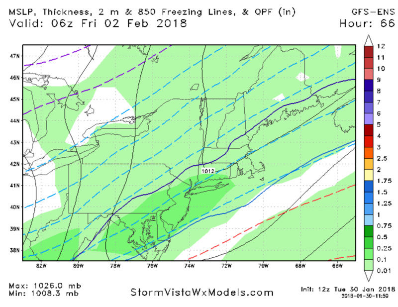
SENJsnowman wrote:which one is the r/s snow line: darker solid blue, lighter solid blue, or easternmost dotted blue line? And what do the other two indicate?
Dark blue is the 32 degree line. I’ve learned that it means nothing this far out
Guest- Guest
Re: Long Range Thread 16.0
![]() by aiannone Tue Jan 30, 2018 3:39 pm
by aiannone Tue Jan 30, 2018 3:39 pm
syosnow94 wrote:SENJsnowman wrote:which one is the r/s snow line: darker solid blue, lighter solid blue, or easternmost dotted blue line? And what do the other two indicate?
Dark blue is the 32 degree line. I’ve learned that it means nothing this far out
Correct. for example last night. If you look at how far the 32 degree line was projected to be, you'd think rain for sure, however other factors such as evap or dynamic cooling come into play. So for this event you can see it has plenty of cold air to the north and also in the upper levels that it can bring in, assuming there is heavy enough precip. So basically if we get some good precip rates with this event, then it should snow. 18z NAM would support this theory.
Pay more attention to set up, the environment the storm is running into, as well as that 0c line which indicates 850mb freezing level. if that's above freezing, ya got a problem likely regardless of rates lol.
_________________
-Alex Iannone-
aiannone- Senior Enthusiast - Mod
- Posts : 4813
Reputation : 92
Join date : 2013-01-07
Location : Saint James, LI (Northwest Suffolk Co.)
Re: Long Range Thread 16.0
![]() by algae888 Tue Jan 30, 2018 4:23 pm
by algae888 Tue Jan 30, 2018 4:23 pm
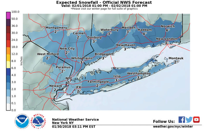
PCPN type forecast is tricky due to thermal profiles being
marginally supportive of wintry weather both near the surface and
aloft. With the bulk of the PCPN falling during nighttime and with
good lift present, thinking is that this can offset a SW-W flow in
the mid levels in the evening before the flow becomes more NW
overnight. Have therefore sided with colder guidance for PCPN types.
Primarily snow NW of the city, and a mix of rain and snow elsewhere
before around midnight before changing to all snow everywhere by
daybreak on Friday. The current forecast has 1 to 2 inches of snow
accumulation through Friday morning for the city and most of NE NJ
with 2-4 inches elsewhere. Will need to see if future model runs
trends higher in qpf in response to the upper jet which would in
turn increase confidence in at least advisory level snowfall
for a good portion of the area.

algae888- Advanced Forecaster

- Posts : 5311
Reputation : 46
Join date : 2013-02-05
Age : 61
Location : mt. vernon, new york
aiannone- Senior Enthusiast - Mod
- Posts : 4813
Reputation : 92
Join date : 2013-01-07
Location : Saint James, LI (Northwest Suffolk Co.)
Re: Long Range Thread 16.0
![]() by jmanley32 Tue Jan 30, 2018 4:37 pm
by jmanley32 Tue Jan 30, 2018 4:37 pm
when all is posting we know things are looking up ; ) hope we can get a advisory snow. But I'd really like one more Godzilla please!!algae888 wrote:nws disco... for thurs night...
PCPN type forecast is tricky due to thermal profiles being
marginally supportive of wintry weather both near the surface and
aloft. With the bulk of the PCPN falling during nighttime and with
good lift present, thinking is that this can offset a SW-W flow in
the mid levels in the evening before the flow becomes more NW
overnight. Have therefore sided with colder guidance for PCPN types.
Primarily snow NW of the city, and a mix of rain and snow elsewhere
before around midnight before changing to all snow everywhere by
daybreak on Friday. The current forecast has 1 to 2 inches of snow
accumulation through Friday morning for the city and most of NE NJ
with 2-4 inches elsewhere. Will need to see if future model runs
trends higher in qpf in response to the upper jet which would in
turn increase confidence in at least advisory level snowfall
for a good portion of the area.
Preferrably Sunday cuz I gotta drive and I dunno when to leave. Psych syo that was for you totally kidding I really can drive in any weather I just hate the traffic snow brings. People around here cannot drive in the snow. Well there are exceptions.

jmanley32- Senior Enthusiast
- Posts : 20516
Reputation : 108
Join date : 2013-12-12
Age : 42
Location : Yonkers, NY
Re: Long Range Thread 16.0
![]() by SENJsnowman Tue Jan 30, 2018 5:08 pm
by SENJsnowman Tue Jan 30, 2018 5:08 pm
aiannone wrote:syosnow94 wrote:SENJsnowman wrote:which one is the r/s snow line: darker solid blue, lighter solid blue, or easternmost dotted blue line? And what do the other two indicate?
Dark blue is the 32 degree line. I’ve learned that it means nothing this far out
Correct. for example last night. If you look at how far the 32 degree line was projected to be, you'd think rain for sure, however other factors such as evap or dynamic cooling come into play. So for this event you can see it has plenty of cold air to the north and also in the upper levels that it can bring in, assuming there is heavy enough precip. So basically if we get some good precip rates with this event, then it should snow. 18z NAM would support this theory.
Pay more attention to set up, the environment the storm is running into, as well as that 0c line which indicates 850mb freezing level. if that's above freezing, ya got a problem likely regardless of rates lol.
Thanks for the feedback. Believe me, I have learned a ton from both of you guys about how to 'properly' use the model info, especially in the last couple of weeks how you both use the surface maps at this range, but always in unison with the upper air data.
I figure this far out, I just want to use the 32* line as baseline to see if temp is something that should be monitored if the other factors for a storm all come together. In that respect, it seems like it is something to keep an eye.
To be honest, it's all I can do now to read the surface maps. I think I get what the 850mb means: the lower pressure is found at a higher altitude. So the higher altitude has more reliable info. That and I know it means a lot to Bernie...
It's kind of frustrating cuz I think I understand some things at this point, but half of the time I like can't even figure out how to say what I know or ask an intelligent question about what I don't...so I just sit here and pay attention to you all a bit more.
SENJsnowman- Senior Enthusiast
- Posts : 1186
Reputation : 61
Join date : 2017-01-06
Age : 51
Location : Bayville, NJ
Re: Long Range Thread 16.0
![]() by amugs Tue Jan 30, 2018 6:20 pm
by amugs Tue Jan 30, 2018 6:20 pm

_________________
Mugs
AKA:King: Snow Weenie
Self Proclaimed
WINTER 2014-15 : 55.12" +.02 for 6 coatings (avg. 35")
WINTER 2015-16 Total - 29.8" (Avg 35")
WINTER 2016-17 : 39.5" so far
amugs- Advanced Forecaster - Mod
- Posts : 15093
Reputation : 213
Join date : 2013-01-07
Age : 54
Location : Hillsdale,NJ
Re: Long Range Thread 16.0
![]() by amugs Tue Jan 30, 2018 6:21 pm
by amugs Tue Jan 30, 2018 6:21 pm


_________________
Mugs
AKA:King: Snow Weenie
Self Proclaimed
WINTER 2014-15 : 55.12" +.02 for 6 coatings (avg. 35")
WINTER 2015-16 Total - 29.8" (Avg 35")
WINTER 2016-17 : 39.5" so far
amugs- Advanced Forecaster - Mod
- Posts : 15093
Reputation : 213
Join date : 2013-01-07
Age : 54
Location : Hillsdale,NJ
Re: Long Range Thread 16.0
![]() by amugs Tue Jan 30, 2018 6:25 pm
by amugs Tue Jan 30, 2018 6:25 pm

_________________
Mugs
AKA:King: Snow Weenie
Self Proclaimed
WINTER 2014-15 : 55.12" +.02 for 6 coatings (avg. 35")
WINTER 2015-16 Total - 29.8" (Avg 35")
WINTER 2016-17 : 39.5" so far
amugs- Advanced Forecaster - Mod
- Posts : 15093
Reputation : 213
Join date : 2013-01-07
Age : 54
Location : Hillsdale,NJ
Re: Long Range Thread 16.0
![]() by Guest Tue Jan 30, 2018 6:47 pm
by Guest Tue Jan 30, 2018 6:47 pm
amugs wrote:This is a MASSIVE EPO block Full lattitude holy SNIKEY DIKEY!!!!!!!!!!!!
Nice amugs. I hear you made a cameo appearance in the thread about today’s snow on page 9. Congratulations.
Guest- Guest
Re: Long Range Thread 16.0
![]() by rb924119 Tue Jan 30, 2018 11:32 pm
by rb924119 Tue Jan 30, 2018 11:32 pm
rb924119- Meteorologist
- Posts : 6890
Reputation : 194
Join date : 2013-02-06
Age : 32
Location : Greentown, Pa
Re: Long Range Thread 16.0
![]() by jmanley32 Tue Jan 30, 2018 11:47 pm
by jmanley32 Tue Jan 30, 2018 11:47 pm
yeah gfs verbatim screws entire coast while everyone else gets a roidzilla. thank goodness its a week out.rb924119 wrote:00z SUITE IS BRINGING THE GOODS FOR THE 4th-6th BABAYYYYYYYYYYYYYYYYY!!!!!!! I DONT CARE IF I GOTTA STRAP INTO THE GOD DARN GIMBLE BELT TO REEL THIS SUCKER IN, IM DOING IT FOR US NORTHWESTERNERS!!!!!! COME TO PAPPA!!!!
jmanley32- Senior Enthusiast
- Posts : 20516
Reputation : 108
Join date : 2013-12-12
Age : 42
Location : Yonkers, NY
Re: Long Range Thread 16.0
![]() by CPcantmeasuresnow Wed Jan 31, 2018 12:14 am
by CPcantmeasuresnow Wed Jan 31, 2018 12:14 am
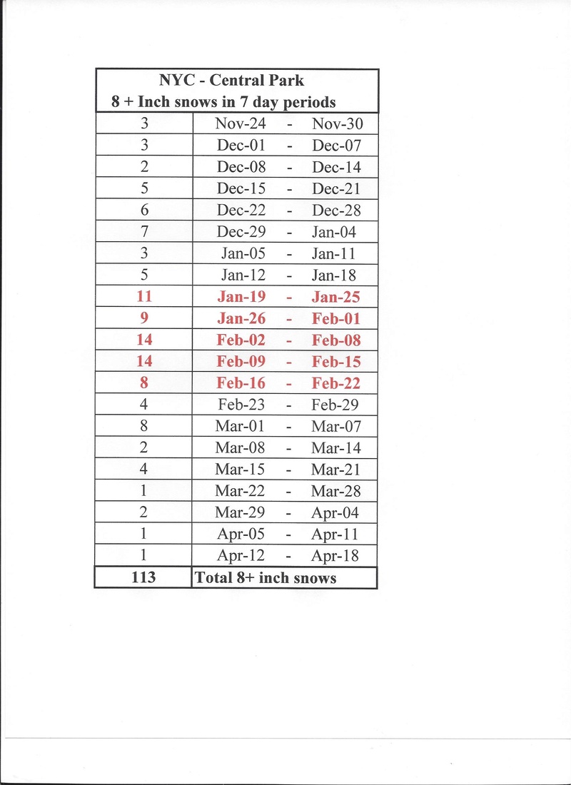
As you can see from the above the 5 week period from late January through most of February is a prime time in NYC for 8+ inch snows. but the 2nd through 15th is prime time. Let's hope history repeats itself.

CPcantmeasuresnow- Wx Statistician Guru

- Posts : 7274
Reputation : 230
Join date : 2013-01-07
Age : 103
Location : Eastern Orange County, NY
Re: Long Range Thread 16.0
![]() by sroc4 Wed Jan 31, 2018 6:23 am
by sroc4 Wed Jan 31, 2018 6:23 am

_________________
"In weather and in life, there's no winning and losing; there's only winning and learning."
WINTER 2012/2013 TOTALS 43.65"WINTER 2017/2018 TOTALS 62.85" WINTER 2022/2023 TOTALS 4.9"
WINTER 2013/2014 TOTALS 64.85"WINTER 2018/2019 TOTALS 14.25" WINTER 2023/2024 TOTALS 13.1"
WINTER 2014/2015 TOTALS 71.20"WINTER 2019/2020 TOTALS 6.35"
WINTER 2015/2016 TOTALS 35.00"WINTER 2020/2021 TOTALS 37.75"
WINTER 2016/2017 TOTALS 42.25"WINTER 2021/2022 TOTALS 31.65"
sroc4- Admin
- Posts : 8331
Reputation : 301
Join date : 2013-01-07
Location : Wading River, LI
Page 34 of 40 • 1 ... 18 ... 33, 34, 35 ... 40 ![]()
|
|
|