
 Search
FEB 17th-18th Snow? Sleet? Rain?
Page 8 of 15 •  1 ... 5 ... 7, 8, 9 ... 11 ... 15
 ![]()
Re: FEB 17th-18th Snow? Sleet? Rain?
![]() by docstox12 Sat Feb 17, 2018 7:08 am
by docstox12 Sat Feb 17, 2018 7:08 am
docstox12- Wx Statistician Guru

- Posts : 8502
Join date : 2013-01-07
Re: FEB 17th-18th Snow? Sleet? Rain?
![]() by Dtone Sat Feb 17, 2018 7:14 am
by Dtone Sat Feb 17, 2018 7:14 am
Sent from Topic'it App
Dtone- Wx Statistician Guru
- Posts : 1738
Join date : 2013-08-26
Re: FEB 17th-18th Snow? Sleet? Rain?
![]() by NjWeatherGuy Sat Feb 17, 2018 7:21 am
by NjWeatherGuy Sat Feb 17, 2018 7:21 am


NjWeatherGuy- Advanced Forecaster

- Posts : 4100
Reputation : 28
Join date : 2013-01-06
Location : Belle Mead, NJ
Re: FEB 17th-18th Snow? Sleet? Rain?
![]() by NjWeatherGuy Sat Feb 17, 2018 7:26 am
by NjWeatherGuy Sat Feb 17, 2018 7:26 am
aiannone wrote:NjWeatherGuy wrote:I think the GFS is out to lunch here. Fairly strong confidence in a stripe of 4-8" about 10-20mi NW of 95, possibly reaching down to 95 and surrounding areas itself but less confidence to the SE. In that bullseye area to the NW we have the combo of likely a heavy period of precip and cold enough temps down to the surface to support snow tomorrow evening, likely to remain an all snow event for CNJ into E-PA and possibly the northern and western part of LI. However, there I am less confident due to potential mixing issues, but I'd say more likely than not to be a moderate snowfall there, probably 3-6". In short, I'm pretty much in line with where the NWS has it's WSW likely to turn to warnings early tomorrow morning.
While I could be wrong, I challenge whether they will be warnings or advisories. I am leaning more towards the advisory. I know for Upton criteria, Warning is 6” or more in a 12 hour period. While this will be a short duration event and the 12 hour threshold will be used over the 24 hour threshold, I believe 6” is the max accumulation they will predict so confidence in meeting 6” area wide will be low. Advisory criteria is 3” or more in a 12hr period. Much more likely. So my opinion: Area wide advisory for 3-5” with isolated amounts to 6”
Yes you're right they dropped the WSW. Technically the right call bc the criteria is 6-7" in the area if I'm not mistaken. While I believe some areas will get there I don't suppose the chances are high enough/ a large enough area for the NWS to bite. I always dislike when they drop a WSW to a WAA for a very close event to warning criteria, as they've done a couple times this winter. The reason being 6" is far more disruptive than 2-3" which are typical advisory snows. A warning makes people take the event seriously and if it were me I would have it up in the northern areas they had the watch where 6-8" are completely in the realm of possibility and even likelihood.
Edit: Upton posted Warnings, Mt. Holly/Binghamton/St. College going with Advisories only.
NjWeatherGuy- Advanced Forecaster
- Posts : 4100
Reputation : 28
Join date : 2013-01-06
Location : Belle Mead, NJ
Re: FEB 17th-18th Snow? Sleet? Rain?
![]() by heehaw453 Sat Feb 17, 2018 7:34 am
by heehaw453 Sat Feb 17, 2018 7:34 am
NjWeatherGuy wrote:Made a map. Using a blend here and hunch with the setup. Obv. tossing the GFS though it is still stubborn, my guess is it goes down with the ship it's on.
Being in Upper Bucks County I like and agree with your map. BL temps though are a concern to me. How far up does the warm tongue push?
heehaw453- Advanced Forecaster
- Posts : 3906
Reputation : 86
Join date : 2014-01-20
Location : Bedminster Township, PA Elevation 600' ASL
Re: FEB 17th-18th Snow? Sleet? Rain?
![]() by CPcantmeasuresnow Sat Feb 17, 2018 7:37 am
by CPcantmeasuresnow Sat Feb 17, 2018 7:37 am
NjWeatherGuy wrote:aiannone wrote:NjWeatherGuy wrote:I think the GFS is out to lunch here. Fairly strong confidence in a stripe of 4-8" about 10-20mi NW of 95, possibly reaching down to 95 and surrounding areas itself but less confidence to the SE. In that bullseye area to the NW we have the combo of likely a heavy period of precip and cold enough temps down to the surface to support snow tomorrow evening, likely to remain an all snow event for CNJ into E-PA and possibly the northern and western part of LI. However, there I am less confident due to potential mixing issues, but I'd say more likely than not to be a moderate snowfall there, probably 3-6". In short, I'm pretty much in line with where the NWS has it's WSW likely to turn to warnings early tomorrow morning.
While I could be wrong, I challenge whether they will be warnings or advisories. I am leaning more towards the advisory. I know for Upton criteria, Warning is 6” or more in a 12 hour period. While this will be a short duration event and the 12 hour threshold will be used over the 24 hour threshold, I believe 6” is the max accumulation they will predict so confidence in meeting 6” area wide will be low. Advisory criteria is 3” or more in a 12hr period. Much more likely. So my opinion: Area wide advisory for 3-5” with isolated amounts to 6”
Yes you're right they dropped the WSW. Technically the right call bc the criteria is 6-7" in the area if I'm not mistaken. While I believe some areas will get there I don't suppose the chances are high enough/ a large enough area for the NWS to bite. I always dislike when they drop a WSW to a WAA for a very close event to warning criteria, as they've done a couple times this winter. The reason being 6" is far more disruptive than 2-3" which are typical advisory snows. A warning makes people take the event seriously and if it were me I would have it up in the northern areas they had the watch where 6-8" are completely in the realm of possibility and even likelihood.
Edit: Upton posted Warnings, Mt. Holly/Binghamton/St. College going with Advisories only.
Upton WSW criteria is 6 inches, in Mt. Holly area it's 5 inches, in Binghamton and Albany it's 7 inches.

CPcantmeasuresnow- Wx Statistician Guru
- Posts : 7274
Reputation : 230
Join date : 2013-01-07
Age : 103
Location : Eastern Orange County, NY
Re: FEB 17th-18th Snow? Sleet? Rain?
![]() by Guest Sat Feb 17, 2018 8:09 am
by Guest Sat Feb 17, 2018 8:09 am
NjWeatherGuy wrote:Made a map. Using a blend here and hunch with the setup. Obv. tossing the GFS though it is still stubborn, my guess is it goes down with the ship it's on.
I actually like your map. You take the topography of the north shore of LI into consideration. It’s one of the only maps I’ve seen people do this with. Nice job. And you put me in the highest category while only giving Scott less than an inch. Double nice
Guest- Guest
Re: FEB 17th-18th Snow? Sleet? Rain?
![]() by Nyi1058 Sat Feb 17, 2018 8:13 am
by Nyi1058 Sat Feb 17, 2018 8:13 am
Nyi1058- Posts : 86
Reputation : 3
Join date : 2013-12-04
Age : 49
Location : Port Jefferson Long Island
Re: FEB 17th-18th Snow? Sleet? Rain?
![]() by Guest Sat Feb 17, 2018 8:15 am
by Guest Sat Feb 17, 2018 8:15 am
Guest- Guest
Re: FEB 17th-18th Snow? Sleet? Rain?
![]() by amugs Sat Feb 17, 2018 8:29 am
by amugs Sat Feb 17, 2018 8:29 am
Thanks for posting and adding to the convoy here.
GFS us abysmal with these marginal thermal profile set ups.
Kudos to Upton staying the course since yesterday overall.
We see what happens but I shall this again this is a nine esque type storm that reminds me of the 70's and 80's to a degree where N&W of NYC saw the heaviest snows while S &E did not.
_________________
Mugs
AKA:King: Snow Weenie
Self Proclaimed
WINTER 2014-15 : 55.12" +.02 for 6 coatings (avg. 35")
WINTER 2015-16 Total - 29.8" (Avg 35")
WINTER 2016-17 : 39.5" so far

amugs- Advanced Forecaster - Mod

- Posts : 15093
Reputation : 213
Join date : 2013-01-07
Age : 54
Location : Hillsdale,NJ
Re: FEB 17th-18th Snow? Sleet? Rain?
![]() by NjWeatherGuy Sat Feb 17, 2018 8:58 am
by NjWeatherGuy Sat Feb 17, 2018 8:58 am
syosnow94 wrote:One thing to consider maybe. It was supposed to get down into the mid 20s last night but I fell 4 degrees short in my back yard. It’s currently 31 and sunny. Let’s hope temps don’t get too high because we are skating a very fine line here. If temps bust 3-4 degrees high with this storm like they are now we rain.
Thanks for the map compliment btw, much obliged. But overall similar here, forecast mid 20s but my therm says we only got to 28-29, I'm not overly concerned. I think it will be a tight gradient in some areas however (what else is new...) with areas getting mostly rain the whole storm and areas just miles to the NW all snow with several inches more. I'm still liking 95 as this general area and the LIE in the western half of LI as the general battle line. I'm not seeing this as a storm in which the line shifts a lot, where it sets up early on will make or break the forecast.
NjWeatherGuy- Advanced Forecaster
- Posts : 4100
Reputation : 28
Join date : 2013-01-06
Location : Belle Mead, NJ
Re: FEB 17th-18th Snow? Sleet? Rain?
![]() by NjWeatherGuy Sat Feb 17, 2018 9:00 am
by NjWeatherGuy Sat Feb 17, 2018 9:00 am
CPcantmeasuresnow wrote:NjWeatherGuy wrote:aiannone wrote:NjWeatherGuy wrote:I think the GFS is out to lunch here. Fairly strong confidence in a stripe of 4-8" about 10-20mi NW of 95, possibly reaching down to 95 and surrounding areas itself but less confidence to the SE. In that bullseye area to the NW we have the combo of likely a heavy period of precip and cold enough temps down to the surface to support snow tomorrow evening, likely to remain an all snow event for CNJ into E-PA and possibly the northern and western part of LI. However, there I am less confident due to potential mixing issues, but I'd say more likely than not to be a moderate snowfall there, probably 3-6". In short, I'm pretty much in line with where the NWS has it's WSW likely to turn to warnings early tomorrow morning.
While I could be wrong, I challenge whether they will be warnings or advisories. I am leaning more towards the advisory. I know for Upton criteria, Warning is 6” or more in a 12 hour period. While this will be a short duration event and the 12 hour threshold will be used over the 24 hour threshold, I believe 6” is the max accumulation they will predict so confidence in meeting 6” area wide will be low. Advisory criteria is 3” or more in a 12hr period. Much more likely. So my opinion: Area wide advisory for 3-5” with isolated amounts to 6”
Yes you're right they dropped the WSW. Technically the right call bc the criteria is 6-7" in the area if I'm not mistaken. While I believe some areas will get there I don't suppose the chances are high enough/ a large enough area for the NWS to bite. I always dislike when they drop a WSW to a WAA for a very close event to warning criteria, as they've done a couple times this winter. The reason being 6" is far more disruptive than 2-3" which are typical advisory snows. A warning makes people take the event seriously and if it were me I would have it up in the northern areas they had the watch where 6-8" are completely in the realm of possibility and even likelihood.
Edit: Upton posted Warnings, Mt. Holly/Binghamton/St. College going with Advisories only.
Upton WSW criteria is 6 inches, in Mt. Holly area it's 5 inches, in Binghamton and Albany it's 7 inches.
In that case I would have definitely kept the WSW. I thought it was more for some reason, those numbers are easily achievable and likely to be surpassed in many areas IMO north of 78.
NjWeatherGuy- Advanced Forecaster
- Posts : 4100
Reputation : 28
Join date : 2013-01-06
Location : Belle Mead, NJ

NjWeatherGuy- Advanced Forecaster
- Posts : 4100
Reputation : 28
Join date : 2013-01-06
Location : Belle Mead, NJ
Re: FEB 17th-18th Snow? Sleet? Rain?
![]() by aiannone Sat Feb 17, 2018 9:13 am
by aiannone Sat Feb 17, 2018 9:13 am
_________________
-Alex Iannone-

aiannone- Senior Enthusiast - Mod
- Posts : 4813
Reputation : 92
Join date : 2013-01-07
Location : Saint James, LI (Northwest Suffolk Co.)
Re: FEB 17th-18th Snow? Sleet? Rain?
![]() by aiannone Sat Feb 17, 2018 9:15 am
by aiannone Sat Feb 17, 2018 9:15 am
_________________
-Alex Iannone-
aiannone- Senior Enthusiast - Mod
- Posts : 4813
Reputation : 92
Join date : 2013-01-07
Location : Saint James, LI (Northwest Suffolk Co.)
Re: FEB 17th-18th Snow? Sleet? Rain?
![]() by aiannone Sat Feb 17, 2018 9:19 am
by aiannone Sat Feb 17, 2018 9:19 am
_________________
-Alex Iannone-
aiannone- Senior Enthusiast - Mod
- Posts : 4813
Reputation : 92
Join date : 2013-01-07
Location : Saint James, LI (Northwest Suffolk Co.)
Re: FEB 17th-18th Snow? Sleet? Rain?
![]() by billg315 Sat Feb 17, 2018 9:48 am
by billg315 Sat Feb 17, 2018 9:48 am

billg315- Advanced Forecaster - Mod
- Posts : 4462
Reputation : 185
Join date : 2015-01-24
Age : 50
Location : Flemington, NJ
Re: FEB 17th-18th Snow? Sleet? Rain?
![]() by Dunnzoo Sat Feb 17, 2018 9:50 am
by Dunnzoo Sat Feb 17, 2018 9:50 am
_________________
Janet
Snowfall winter of 2023-2024 17.5"
Snowfall winter of 2022-2023 6.0"
Snowfall winter of 2021-2022 17.6" 1" sleet 2/25/22
Snowfall winter of 2020-2021 51.1"
Snowfall winter of 2019-2020 8.5"
Snowfall winter of 2018-2019 25.1"
Snowfall winter of 2017-2018 51.9"
Snowfall winter of 2016-2017 45.6"
Snowfall winter of 2015-2016 29.5"
Snowfall winter of 2014-2015 50.55"
Snowfall winter of 2013-2014 66.5"

Dunnzoo- Senior Enthusiast - Mod
- Posts : 4886
Reputation : 68
Join date : 2013-01-11
Age : 62
Location : Westwood, NJ
Re: FEB 17th-18th Snow? Sleet? Rain?
![]() by SoulSingMG Sat Feb 17, 2018 10:02 am
by SoulSingMG Sat Feb 17, 2018 10:02 am


SoulSingMG- Senior Enthusiast

- Posts : 2853
Reputation : 74
Join date : 2013-12-11
Location : Long Island City, NY
Re: FEB 17th-18th Snow? Sleet? Rain?
![]() by aiannone Sat Feb 17, 2018 10:21 am
by aiannone Sat Feb 17, 2018 10:21 am
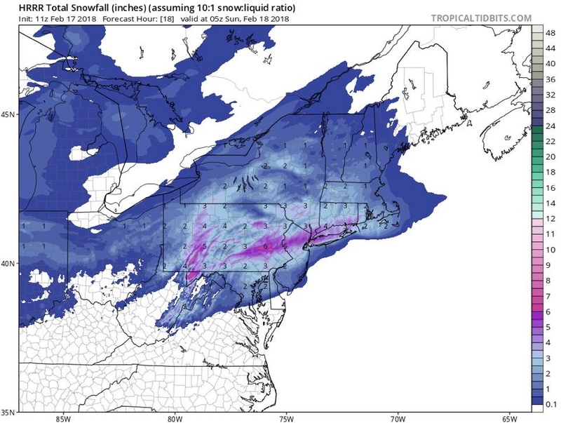
SoulSingMG wrote:latest HRRR upped amounts a bit... It's gonna THUMP later!
Wow that would make the whole board happy
_________________
-Alex Iannone-
aiannone- Senior Enthusiast - Mod
- Posts : 4813
Reputation : 92
Join date : 2013-01-07
Location : Saint James, LI (Northwest Suffolk Co.)
Re: FEB 17th-18th Snow? Sleet? Rain?
![]() by NjWeatherGuy Sat Feb 17, 2018 10:30 am
by NjWeatherGuy Sat Feb 17, 2018 10:30 am
NjWeatherGuy- Advanced Forecaster
- Posts : 4100
Reputation : 28
Join date : 2013-01-06
Location : Belle Mead, NJ
Re: FEB 17th-18th Snow? Sleet? Rain?
![]() by SENJsnowman Sat Feb 17, 2018 10:37 am
by SENJsnowman Sat Feb 17, 2018 10:37 am
aiannone wrote:SoulSingMG wrote:latest HRRR upped amounts a bit... It's gonna THUMP later!
Wow that would make the whole board happy
This is the first positive sign out yet of the short range models for the Jersey Shore...I'm still expecting closer to 0" than 1-2", but we'll see!
SENJsnowman- Senior Enthusiast
- Posts : 1186
Reputation : 61
Join date : 2017-01-06
Age : 51
Location : Bayville, NJ
Re: FEB 17th-18th Snow? Sleet? Rain?
![]() by NjWeatherGuy Sat Feb 17, 2018 10:38 am
by NjWeatherGuy Sat Feb 17, 2018 10:38 am
NjWeatherGuy- Advanced Forecaster
- Posts : 4100
Reputation : 28
Join date : 2013-01-06
Location : Belle Mead, NJ
Re: FEB 17th-18th Snow? Sleet? Rain?
![]() by aiannone Sat Feb 17, 2018 10:46 am
by aiannone Sat Feb 17, 2018 10:46 am

_________________
-Alex Iannone-
aiannone- Senior Enthusiast - Mod
- Posts : 4813
Reputation : 92
Join date : 2013-01-07
Location : Saint James, LI (Northwest Suffolk Co.)
Re: FEB 17th-18th Snow? Sleet? Rain?
![]() by NjWeatherGuy Sat Feb 17, 2018 11:00 am
by NjWeatherGuy Sat Feb 17, 2018 11:00 am
aiannone wrote:Highway signs up and running on LI
Good call by Upton here. I still think Mt. Holly ought to raise warnings for the northern half of the state to be on the safe side, if they don't by this afternoon they probably will just stick with the advisory.
NjWeatherGuy- Advanced Forecaster
- Posts : 4100
Reputation : 28
Join date : 2013-01-06
Location : Belle Mead, NJ
Re: FEB 17th-18th Snow? Sleet? Rain?
![]() by algae888 Sat Feb 17, 2018 11:00 am
by algae888 Sat Feb 17, 2018 11:00 am

algae888- Advanced Forecaster
- Posts : 5311
Reputation : 46
Join date : 2013-02-05
Age : 61
Location : mt. vernon, new york
Re: FEB 17th-18th Snow? Sleet? Rain?
![]() by aiannone Sat Feb 17, 2018 11:39 am
by aiannone Sat Feb 17, 2018 11:39 am
_________________
-Alex Iannone-
aiannone- Senior Enthusiast - Mod
- Posts : 4813
Reputation : 92
Join date : 2013-01-07
Location : Saint James, LI (Northwest Suffolk Co.)
Page 8 of 15 • 1 ... 5 ... 7, 8, 9 ... 11 ... 15 ![]()
|
|
|