
 Search
Long Range Thread 16.0
Page 1 of 34 • 1, 2, 3 ... 17 ... 34 ![]()

Long Range Thread 16.0
![]() by amugs Sun Feb 11, 2018 5:25 pm
by amugs Sun Feb 11, 2018 5:25 pm
"What some don't get is that it is not just one piece that will make our pattern but many variable when it come to winter and what is happening 10,000 plus miles away has a profound effect on this in both directions - upstream and downstream."
So some may have hunches, a feeling,get it right for the wrong reasons. What we try to do is give you the what and why here. NO ONE SAW the warmth as progged to this degree in the extended range in part due to this typhoon that that is going to recurve in the phase 7 MJO section off Austin land. If you did show the proof if your call and I will ask Frank to make you a moderator for a day LOL!!
_________________
Mugs
AKA:King: Snow Weenie
Self Proclaimed
WINTER 2014-15 : 55.12" +.02 for 6 coatings (avg. 35")
WINTER 2015-16 Total - 29.8" (Avg 35")
WINTER 2016-17 : 39.5" so far

amugs- Advanced Forecaster - Mod

- Posts : 15093
Reputation : 213
Join date : 2013-01-07
Age : 54
Location : Hillsdale,NJ
Re: Long Range Thread 16.0
![]() by track17 Sun Feb 11, 2018 5:46 pm
by track17 Sun Feb 11, 2018 5:46 pm
track17- Posts : 454
Reputation : 4
Join date : 2016-01-09
Re: Long Range Thread 16.0
![]() by Guest Sun Feb 11, 2018 6:03 pm
by Guest Sun Feb 11, 2018 6:03 pm
track17 wrote:I don't know how complimenting someone is being a jerk or stirring the pot. I was doing neither nor was it my intention. Kinda sad I try and be nice and get attacked. If you thought that I am sorry, but I truly think your posts are great syo
If this post is serious and I actually misunderstood the intentions of your post then I apologize
Guest- Guest
Re: Long Range Thread 16.0
![]() by track17 Sun Feb 11, 2018 6:04 pm
by track17 Sun Feb 11, 2018 6:04 pm
track17- Posts : 454
Reputation : 4
Join date : 2016-01-09
Re: Long Range Thread 16.0
![]() by track17 Sun Feb 11, 2018 6:05 pm
by track17 Sun Feb 11, 2018 6:05 pm
track17- Posts : 454
Reputation : 4
Join date : 2016-01-09
Re: Long Range Thread 16.0
![]() by amugs Sun Feb 11, 2018 6:13 pm
by amugs Sun Feb 11, 2018 6:13 pm
_________________
Mugs
AKA:King: Snow Weenie
Self Proclaimed
WINTER 2014-15 : 55.12" +.02 for 6 coatings (avg. 35")
WINTER 2015-16 Total - 29.8" (Avg 35")
WINTER 2016-17 : 39.5" so far
amugs- Advanced Forecaster - Mod
- Posts : 15093
Reputation : 213
Join date : 2013-01-07
Age : 54
Location : Hillsdale,NJ
Re: Long Range Thread 16.0
![]() by Guest Sun Feb 11, 2018 6:15 pm
by Guest Sun Feb 11, 2018 6:15 pm
Guest- Guest
Re: Long Range Thread 16.0
![]() by Guest Sun Feb 11, 2018 6:18 pm
by Guest Sun Feb 11, 2018 6:18 pm
Guest- Guest
Re: Long Range Thread 16.0
![]() by track17 Sun Feb 11, 2018 6:28 pm
by track17 Sun Feb 11, 2018 6:28 pm
track17- Posts : 454
Reputation : 4
Join date : 2016-01-09
Re: Long Range Thread 16.0
![]() by CPcantmeasuresnow Sun Feb 11, 2018 7:13 pm
by CPcantmeasuresnow Sun Feb 11, 2018 7:13 pm
track17 wrote:Serious question? I asked this before but honestly the answer was not phrased in a way I could understand. It was well answered but went well above my head. My question is will we have any shot in the future of seeing a non Nino or Nina event. Every winter seems to be one or th other lately. It seems we do better when it is neither. Could this happen in the next few yrs. again sorry for not understanding the original answer but I am not as smart as some on here
Like [X] - I like the question, but unfortunately I too lack the smarts to answer it, hopefully someone smarter than either of us does.

CPcantmeasuresnow- Wx Statistician Guru

- Posts : 7274
Reputation : 230
Join date : 2013-01-07
Age : 103
Location : Eastern Orange County, NY
Re: Long Range Thread 16.0
![]() by crippo84 Sun Feb 11, 2018 7:48 pm
by crippo84 Sun Feb 11, 2018 7:48 pm
CPcantmeasuresnow wrote:track17 wrote:Serious question? I asked this before but honestly the answer was not phrased in a way I could understand. It was well answered but went well above my head. My question is will we have any shot in the future of seeing a non Nino or Nina event. Every winter seems to be one or th other lately. It seems we do better when it is neither. Could this happen in the next few yrs. again sorry for not understanding the original answer but I am not as smart as some on here
Like [X] - I like the question, but unfortunately I too lack the smarts to answer it, hopefully someone smarter than either of us does.
Haha...just as CP mentions in banter thread I do like the idea of a like button.

crippo84- Posts : 383
Reputation : 20
Join date : 2013-11-07
Age : 40
Location : East Village, NYC
Re: Long Range Thread 16.0
![]() by Guest Sun Feb 11, 2018 8:52 pm
by Guest Sun Feb 11, 2018 8:52 pm
CPcantmeasuresnow wrote:track17 wrote:Serious question? I asked this before but honestly the answer was not phrased in a way I could understand. It was well answered but went well above my head. My question is will we have any shot in the future of seeing a non Nino or Nina event. Every winter seems to be one or th other lately. It seems we do better when it is neither. Could this happen in the next few yrs. again sorry for not understanding the original answer but I am not as smart as some on here
Like [X] - I like the question, but unfortunately I too lack the smarts to answer it, hopefully someone smarter than either of us does.
I too get very confused. Some say La NinA bad some say good. Some say El Niño bad some say good. I actually have always believed both were good as long as they weren’t too strong. But this year we have a weak La Niña and it looks like the last two months of winter will be washed away so WHO THE HELL KNOWS.
Sorry again Track
Guest- Guest
Re: Long Range Thread 16.0
![]() by track17 Sun Feb 11, 2018 9:25 pm
by track17 Sun Feb 11, 2018 9:25 pm
track17- Posts : 454
Reputation : 4
Join date : 2016-01-09
Re: Long Range Thread 16.0
![]() by Frank_Wx Mon Feb 12, 2018 10:06 am
by Frank_Wx Mon Feb 12, 2018 10:06 am

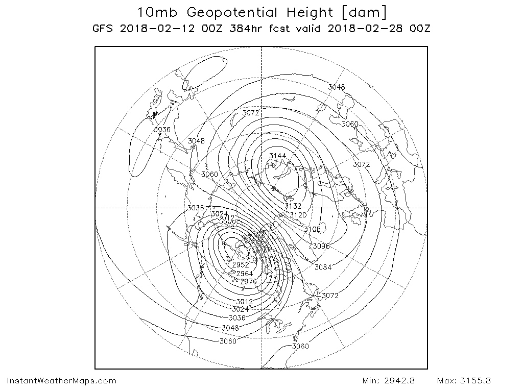
A major sudden stratospheric warming event is taking place as we speak. In short, this is when warm air penetrates into the mid and upper levels of the Stratosphere and displaces the Stratospheric PV away from the Arctic (North Pole). However, check out where the PV is being displaced to - over western Canada. This is not an ideal spot we want the PV to go. This suggests the trough will be over western-central U.S. and not favorably positioned for east coast cold / snowstorms.
That being said, I expect the NAO to go substantially negative by the end of February. However, if the Pacific is unfavorable then that will not do much for us. We desperately need forcing (the MJO) to help us out the end of February. If the Pacific can fix itself on current guidance, then end of February into the first 10 days of March could produce record breaking cold and snowstorms. This is UNLIKELY at this time but the potential is there if the Pacific can overcome the stratospheric warming event.

Granted this is a 384hr chart, but just to show the idea of the NAO going negative. Check out those positive height anomalies over Greenland!
Unfortunately, the next 10 days you can expect milder than normal and wet conditions. If the Pacific does not cooperate for us then we're most likely headed to a pretty warm March as well.
_________________
_______________________________________________________________________________________________________
CLICK HERE to view NJ Strong Snowstorm Classifications

Frank_Wx- Godzilla Seeker

- Posts : 21305
Reputation : 328
Join date : 2013-01-05
Age : 31
Location : Jersey City, NJ -

Re: Long Range Thread 16.0
![]() by Frank_Wx Mon Feb 12, 2018 10:25 am
by Frank_Wx Mon Feb 12, 2018 10:25 am
Now I am seeing a major sudden stratospheric warming event taking place. While this looks to be a very impressive event I caution that it may not deliver the results you may expect. The NAO is likely to go negative the end of this month into March, but the Strat PV is being displaced to western Canada and that may keep the trough over western/central U.S. Furthermore, some evidence suggests the MJO will remain in unfavorable phases which will also prevent the Pacific from turning favorable.
I would not completely discount the end of FEB into MAR. If the PAC finds a way to turn favorable, even for a 1-week period, it could deliver one last major snowstorm to our area as long as the NAO indeed does go negative. However, I would bet against that for right now. The next 10 days look mild and that is the reality of the situation at the moment. We'll see what happens!
_________________
_______________________________________________________________________________________________________
CLICK HERE to view NJ Strong Snowstorm Classifications
Frank_Wx- Godzilla Seeker
- Posts : 21305
Reputation : 328
Join date : 2013-01-05
Age : 31
Location : Jersey City, NJ -
Re: Long Range Thread 16.0
![]() by MattyICE Mon Feb 12, 2018 5:22 pm
by MattyICE Mon Feb 12, 2018 5:22 pm
MattyICE- Advanced Forecaster

- Posts : 249
Reputation : 6
Join date : 2017-11-10
Age : 38
Location : Clifton, NJ (Eastern Passaic County)
Re: Long Range Thread 16.0
![]() by CPcantmeasuresnow Mon Feb 12, 2018 5:53 pm
by CPcantmeasuresnow Mon Feb 12, 2018 5:53 pm
MattyICE wrote:Obviously we’d all prefer it was pretty much any two other models...but...the CMC and German both see a way for some snow this weekend. Also would prefer if they didn’t slide the high as quickly off the NE coast. I do not think this will happen, but it’s the only thing even remotely close to trackable in the next 10+ days.
Like [X]
CPcantmeasuresnow- Wx Statistician Guru
- Posts : 7274
Reputation : 230
Join date : 2013-01-07
Age : 103
Location : Eastern Orange County, NY
Re: Long Range Thread 16.0
![]() by sroc4 Mon Feb 12, 2018 5:56 pm
by sroc4 Mon Feb 12, 2018 5:56 pm
https://twitter.com/zd1awrence/status/963086384222289920
_________________
"In weather and in life, there's no winning and losing; there's only winning and learning."
WINTER 2012/2013 TOTALS 43.65"WINTER 2017/2018 TOTALS 62.85" WINTER 2022/2023 TOTALS 4.9"
WINTER 2013/2014 TOTALS 64.85"WINTER 2018/2019 TOTALS 14.25" WINTER 2023/2024 TOTALS 13.1"
WINTER 2014/2015 TOTALS 71.20"WINTER 2019/2020 TOTALS 6.35"
WINTER 2015/2016 TOTALS 35.00"WINTER 2020/2021 TOTALS 37.75"
WINTER 2016/2017 TOTALS 42.25"WINTER 2021/2022 TOTALS 31.65"

sroc4- Admin
- Posts : 8331
Reputation : 301
Join date : 2013-01-07
Location : Wading River, LI
Re: Long Range Thread 16.0
![]() by Snow88 Mon Feb 12, 2018 6:04 pm
by Snow88 Mon Feb 12, 2018 6:04 pm

Snow88- Senior Enthusiast

- Posts : 2193
Reputation : 4
Join date : 2013-01-09
Age : 35
Location : Brooklyn, NY
Re: Long Range Thread 16.0
![]() by algae888 Tue Feb 13, 2018 6:19 am
by algae888 Tue Feb 13, 2018 6:19 am

algae888- Advanced Forecaster
- Posts : 5311
Reputation : 46
Join date : 2013-02-05
Age : 61
Location : mt. vernon, new york
Re: Long Range Thread 16.0
![]() by sroc4 Tue Feb 13, 2018 7:10 am
by sroc4 Tue Feb 13, 2018 7:10 am
algae888 wrote:That is one crazy n a o block on all guidance especially on the g e f s. Watch for a sneaky little snow storm Saturday night into Sunday. While the cold air looks to be across Eurasia and out west we only need cold enough air for snow and with that Nao block we should have systems cutting underneath us late February into early March we'll see what happens
You beat me to it Al. And I agree with you regarding this weekend. Similar set up to the last couple of systems we've had around these parts. The rain Frank has in the scroll for Thursday and Friday will drop the boundary S&E of us bringing in cold air thanks to a HP dropping out of Canada. A second weak wave of LP will develop along that boundary and move ENE along it off our coast. We will have the same prob; however, we have had with the last 2-3 systems in that there is not enough up stream ridging to allow the system to dig and come up the coast and there is no down stream blocking to keep the HP in place.
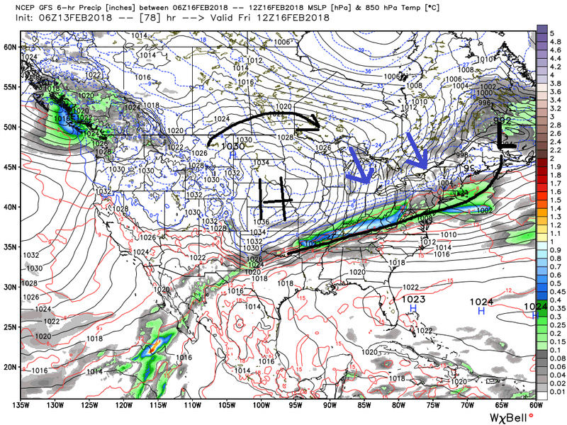
So what we will likely have here is a system that either A) slides harmlessly to our south, or B) cold air damning hold strong for awhile and we get an initial over running event as moisture runs into the cold air(Warm air advection WAA), and we get an initial period of snow then sleet then change to rain scenario. As in the prev systems the areas N&W def stand to benefit the most by this; whereas, the coast is more likely to change over quicker. Storm track dictates how, when where and if we see change over etc. Well see.
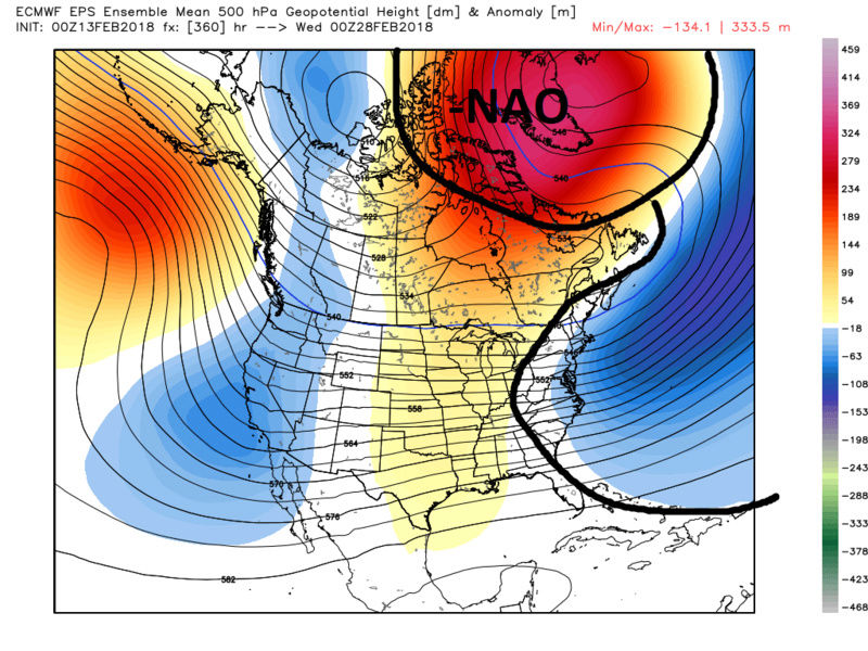
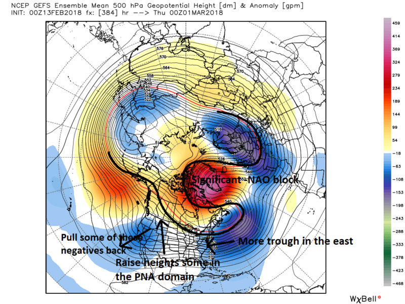
But also like Al mentions the most impressive NAO block I can remember is starting to show itself in the modeling on both GEFs and EPS. When ever I look at the LR I always look at the most anomalous feature or couple of features on the ensemble means to see where things might be going. Listen its a long way out and its another discussion where "the pattern was delayed but its coming" scenario, so read this with a grain of salt if you will. That's said:
By day 10 the most anomalous features on the map remains the ridge south of the Aleutian islands; too far west forcing the trough in the south western CONUS; therefore, SE ridge flexes in the east. Blah! However, we have started to see higher heights or ridging developing over Greenland. Verbatim this is a weak east based -NAO here.
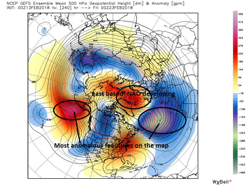
BUT, as we cont in time pay attention to the ridging over Greenland. Wee end up with a very strong anomalous west based -NAO block on both the GEFS and EPS verbatim. Here are the EPS and GEFs starting Day 10, 12, 14 then 16. Notice as the ridge backs into Greenland the trough that has been parked out ove the Atlantic backs into the EC of the CONUS.
EPS:
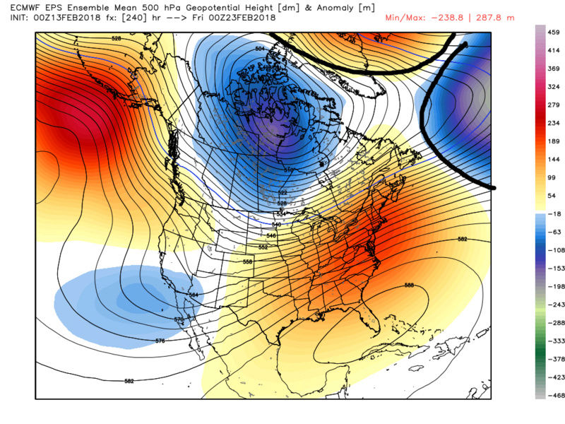
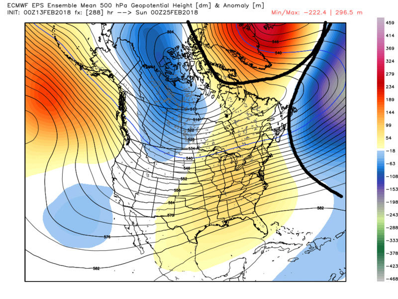
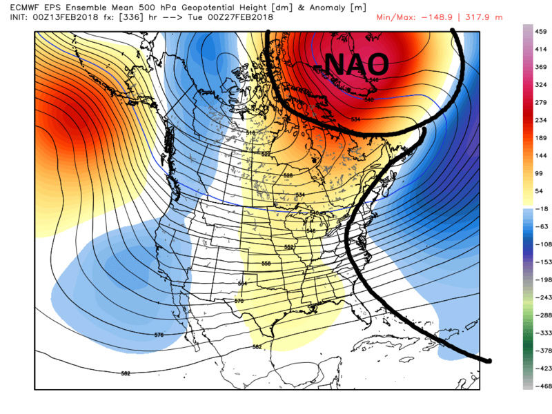
GEFS:

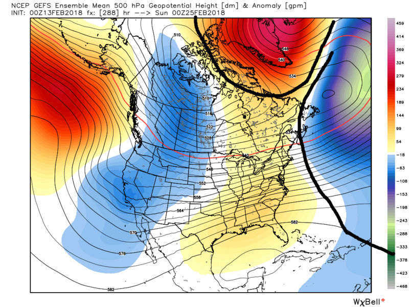

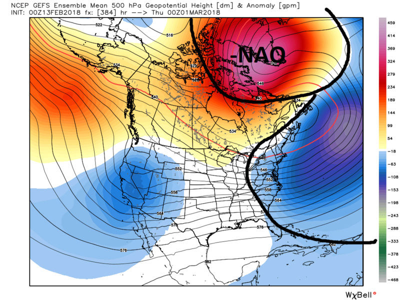
If the NAO block sets up like this it would be like dropping a giant boulder into a stream down stream from our location. There will be major up stream effects from this leading to a pattern that likely wont feature major BN temp departures, but rather N to BN with a pattern that is def cold enough for snow and a pattern favorable such that it would allow for snow storms along the coast to develop. Again if the NAO region develops like the ensemble means are hinting at the up stream effects will go something like this:
Although it wont be pretty for the next 10-14d I still believe we ALL will be breaking out the ruler at least 1-3 more times this winter season. At least that's where I am at right now. GEFS MJO forecast for the first time may have finally hinted at this to support the above discussion. We shall see what the next week holds.
_________________
"In weather and in life, there's no winning and losing; there's only winning and learning."
WINTER 2012/2013 TOTALS 43.65"WINTER 2017/2018 TOTALS 62.85" WINTER 2022/2023 TOTALS 4.9"
WINTER 2013/2014 TOTALS 64.85"WINTER 2018/2019 TOTALS 14.25" WINTER 2023/2024 TOTALS 13.1"
WINTER 2014/2015 TOTALS 71.20"WINTER 2019/2020 TOTALS 6.35"
WINTER 2015/2016 TOTALS 35.00"WINTER 2020/2021 TOTALS 37.75"
WINTER 2016/2017 TOTALS 42.25"WINTER 2021/2022 TOTALS 31.65"
sroc4- Admin
- Posts : 8331
Reputation : 301
Join date : 2013-01-07
Location : Wading River, LI
Re: Long Range Thread 16.0
![]() by aiannone Tue Feb 13, 2018 8:13 am
by aiannone Tue Feb 13, 2018 8:13 am
_________________
-Alex Iannone-

aiannone- Senior Enthusiast - Mod
- Posts : 4813
Reputation : 92
Join date : 2013-01-07
Location : Saint James, LI (Northwest Suffolk Co.)
Re: Long Range Thread 16.0
![]() by Snow88 Tue Feb 13, 2018 9:04 am
by Snow88 Tue Feb 13, 2018 9:04 am
"We have a coupled troposphere and stratosphere now in the midst of a record breaking SSW. The easterly wind reversal at 10mb looks record breaking and so does the anomalous temperature rise. As a ridge anomaly shifts south from the Barents Sea and multiple +heat flux events continue into the polar stratosphere, the potential exists for an extremely anomalous high latitude blocking event on the Atlantic side of the high latitudes towards the end of the month.
The actual impacts to our area remain undetermined. I remain confident we will have opportunities for significant snow. But I think there is a larger, more broad pattern change occurring here, with a near-decadal flip back toward a Atlantic blocking pattern possible. We saw a similar event about 9 years ago. Watching the Pacific reshuffle has been impressive on the ensemble means as well.
To back up for a moment, I guess what I am saying is that despite the confidence in the Atlantic blocking, things are still evolving in the Pacific. I think we should be careful with that as we may be fighting a bit if a trough establishes in the Western US. But the size and scope of potential Atlantic blocking tells me we should have a few shots at big winter storms. "
Snow88- Senior Enthusiast
- Posts : 2193
Reputation : 4
Join date : 2013-01-09
Age : 35
Location : Brooklyn, NY
Re: Long Range Thread 16.0
![]() by Snow88 Tue Feb 13, 2018 10:33 am
by Snow88 Tue Feb 13, 2018 10:33 am
http://www.cpc.ncep.noaa.gov/products/precip/CWlink/daily_ao_index/ao.shtml
NAO going down to -2
http://www.cpc.ncep.noaa.gov/products/precip/CWlink/daily_ao_index/ao.shtml
Snow88- Senior Enthusiast
- Posts : 2193
Reputation : 4
Join date : 2013-01-09
Age : 35
Location : Brooklyn, NY
Re: Long Range Thread 16.0
![]() by Snow88 Tue Feb 13, 2018 10:59 am
by Snow88 Tue Feb 13, 2018 10:59 am
Snow88- Senior Enthusiast
- Posts : 2193
Reputation : 4
Join date : 2013-01-09
Age : 35
Location : Brooklyn, NY
Page 1 of 34 • 1, 2, 3 ... 17 ... 34 ![]()
|
|
|