
 Search
Winter's Finale: March 20th-21st Snowstorm
Page 28 of 29 •  1 ... 15 ... 27, 28, 29
 ![]()
Re: Winter's Finale: March 20th-21st Snowstorm
![]() by CPcantmeasuresnow Tue Mar 20, 2018 5:34 am
by CPcantmeasuresnow Tue Mar 20, 2018 5:34 am
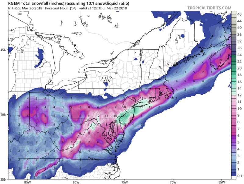
The 6Z NAM has me concerned as do other runs that seem to hit a brick wall with the precip at certain points north and west. Nowcast as usual.
CPcantmeasuresnow- Wx Statistician Guru

- Posts : 7274
Join date : 2013-01-07
skinsfan1177- Senior Enthusiast

- Posts : 4485
Join date : 2013-01-07
Re: Winter's Finale: March 20th-21st Snowstorm
![]() by Taffy Tue Mar 20, 2018 5:36 am
by Taffy Tue Mar 20, 2018 5:36 am
Scullybutcher wrote:This is what Upton has for me.
* WHAT...HEAVY MIXED WINTER PRECIPITATION TRANSITIONING TO HEAVY
SNOW IS EXPECTED. TOTAL SNOW ACCUMULATIONS OF 7 TO 10 INCHES,
WITH LOCALIZED AMOUNTS UP TO 13 INCHES, AND LIGHT ICE
ACCUMULATIONS ARE EXPECTED.
The weather channel has me for 13 - 20”
Nice, Scully! NWS had my area at 12-16 with light ice accumulation possible.
Bill Evans has my area at 6-10 with possible 12 locally. I'm going with the NWS.

Taffy- Pro Enthusiast

- Posts : 530
Reputation : 19
Join date : 2013-10-06
Location : Hopkinton, MA
Re: Winter's Finale: March 20th-21st Snowstorm
![]() by 2004blackwrx Tue Mar 20, 2018 5:36 am
by 2004blackwrx Tue Mar 20, 2018 5:36 am
2004blackwrx- Pro Enthusiast
- Posts : 576
Reputation : 9
Join date : 2013-01-14
Location : Wappinger NY
Re: Winter's Finale: March 20th-21st Snowstorm
![]() by Taffy Tue Mar 20, 2018 5:40 am
by Taffy Tue Mar 20, 2018 5:40 am
Taffy- Pro Enthusiast
- Posts : 530
Reputation : 19
Join date : 2013-10-06
Location : Hopkinton, MA
Re: Winter's Finale: March 20th-21st Snowstorm
![]() by CPcantmeasuresnow Tue Mar 20, 2018 5:40 am
by CPcantmeasuresnow Tue Mar 20, 2018 5:40 am
2004blackwrx wrote:Cp that brick wall is exactly what I see too and has me concerned. We are way to close to the edge when theY show that sharp of a cutoff.
Exactly.
I said last night someone in between an area from central Rockland to northern Dutchess will be on a sharp cutoff zone and the 6Z NAM certainly showed that. I'm hoping it's wrong but even the RGEM that skins posted shows it to a degree. This one may not be our storm despite the NWS WSW for 10-16 inches. Like I said I'm still not buying it for here.

CPcantmeasuresnow- Wx Statistician Guru
- Posts : 7274
Reputation : 230
Join date : 2013-01-07
Age : 103
Location : Eastern Orange County, NY
Re: Winter's Finale: March 20th-21st Snowstorm
![]() by CPcantmeasuresnow Tue Mar 20, 2018 5:42 am
by CPcantmeasuresnow Tue Mar 20, 2018 5:42 am
Taffy wrote:CP and blackwrx.....Please don't rain on my parade! Snowing on it is permissible.
You'll do great down there Taffy. This is a N&W concern.
CPcantmeasuresnow- Wx Statistician Guru
- Posts : 7274
Reputation : 230
Join date : 2013-01-07
Age : 103
Location : Eastern Orange County, NY
Re: Winter's Finale: March 20th-21st Snowstorm
![]() by 2004blackwrx Tue Mar 20, 2018 5:46 am
by 2004blackwrx Tue Mar 20, 2018 5:46 am
2004blackwrx- Pro Enthusiast
- Posts : 576
Reputation : 9
Join date : 2013-01-14
Location : Wappinger NY
Re: Winter's Finale: March 20th-21st Snowstorm
![]() by CPcantmeasuresnow Tue Mar 20, 2018 6:00 am
by CPcantmeasuresnow Tue Mar 20, 2018 6:00 am
Im 3 for 3 this month. No problem watching others cash in if it happens that way. Now cast.
CPcantmeasuresnow- Wx Statistician Guru
- Posts : 7274
Reputation : 230
Join date : 2013-01-07
Age : 103
Location : Eastern Orange County, NY
Re: Winter's Finale: March 20th-21st Snowstorm
![]() by jmanley32 Tue Mar 20, 2018 6:09 am
by jmanley32 Tue Mar 20, 2018 6:09 am

jmanley32- Senior Enthusiast
- Posts : 20513
Reputation : 108
Join date : 2013-12-12
Age : 42
Location : Yonkers, NY
Re: Winter's Finale: March 20th-21st Snowstorm
![]() by SENJsnowman Tue Mar 20, 2018 6:19 am
by SENJsnowman Tue Mar 20, 2018 6:19 am
I'm hoping that if I promise my wife I'll do the taxes, she'll let me take the day off to sit in front of my computer all day. We'll see what she says... ha ha!
SENJsnowman- Senior Enthusiast
- Posts : 1186
Reputation : 61
Join date : 2017-01-06
Age : 51
Location : Bayville, NJ
Re: Winter's Finale: March 20th-21st Snowstorm
![]() by billg315 Tue Mar 20, 2018 6:24 am
by billg315 Tue Mar 20, 2018 6:24 am
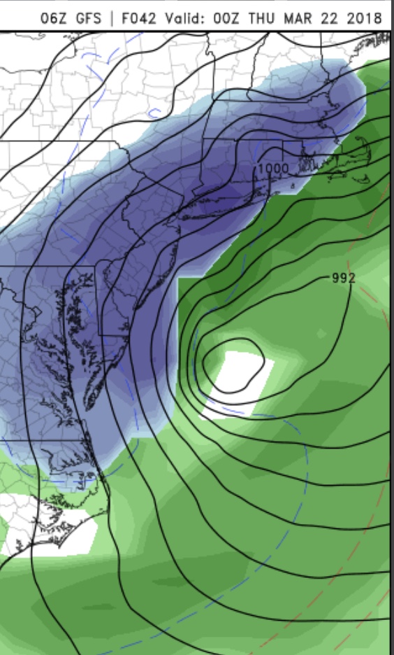
If you look at my last posts last night before I went to bed I said we’d see this shift of the heaviest band east overnight. As I said when this thing deepens it will wrap up tighter pullling the heavier snow closer to the center and cutting things off further north and west.That’s why my map looks like it does. As of this morning I still like my map.jmanley32 wrote:Okay I now have a wsw for 12 to 16 awesome but what happened 06z runs are way east!! Should I be concerned that's a big jump. 3km did not even make sense very little precip of any type in NYC area. I hope they were a blip. Euro was east too.

billg315- Advanced Forecaster - Mod

- Posts : 4462
Reputation : 185
Join date : 2015-01-24
Age : 50
Location : Flemington, NJ
Re: Winter's Finale: March 20th-21st Snowstorm
![]() by gigs68 Tue Mar 20, 2018 6:25 am
by gigs68 Tue Mar 20, 2018 6:25 am

gigs68- Posts : 142
Reputation : 3
Join date : 2013-01-16
Location : Commack, NY (NW Suffolk)
Re: Winter's Finale: March 20th-21st Snowstorm
![]() by jimv45 Tue Mar 20, 2018 6:29 am
by jimv45 Tue Mar 20, 2018 6:29 am
jimv45- Senior Enthusiast
- Posts : 1168
Reputation : 36
Join date : 2013-09-20
Location : Hopewell jct.
Re: Winter's Finale: March 20th-21st Snowstorm
![]() by billg315 Tue Mar 20, 2018 6:32 am
by billg315 Tue Mar 20, 2018 6:32 am
billg315- Advanced Forecaster - Mod
- Posts : 4462
Reputation : 185
Join date : 2015-01-24
Age : 50
Location : Flemington, NJ
Re: Winter's Finale: March 20th-21st Snowstorm
![]() by nutleyblizzard Tue Mar 20, 2018 6:34 am
by nutleyblizzard Tue Mar 20, 2018 6:34 am
I agree with your thoughts. Last nights NAM was too far west with the axis of heaviest snowfall and I thought it would end up east. However the 6z NAM is way east. I think thats just an over correction on the Nams part and it will come back west at 12z more in line with your snow map.billg315 wrote:If you look at my last posts last night before I went to bed I said we’d see this shift of the heaviest band east overnight. As I said when this thing deepens it will wrap up tighter pullling the heavier snow closer to the center and cutting things off further north and west.That’s why my map looks like it does. As of this morning I still like my map.jmanley32 wrote:Okay I now have a wsw for 12 to 16 awesome but what happened 06z runs are way east!! Should I be concerned that's a big jump. 3km did not even make sense very little precip of any type in NYC area. I hope they were a blip. Euro was east too.

nutleyblizzard- Senior Enthusiast
- Posts : 1952
Reputation : 41
Join date : 2014-01-30
Age : 58
Location : Nutley, new jersey
Re: Winter's Finale: March 20th-21st Snowstorm
![]() by hyde345 Tue Mar 20, 2018 6:35 am
by hyde345 Tue Mar 20, 2018 6:35 am
CPcantmeasuresnow wrote:The 6Z GFS has the heavy stuff after 4 past midnight. That would be a plus for accumulating. It also has a sharp cutoff to the north but not as extreme as the 6Z NAM. Anyone north of the TZ bridge should be concerned IMO.
Im 3 for 3 this month. No problem watching others cash in if it happens that way. Now cast.
I think Westchester and Rockland will do fine. It's further north and west that could be in trouble. There is a sharp cutoff and the 06z nam and rgem don't do me any favors. Even the Euro gives me about .30 of LE. I wouldn't be a bit surprised with much less than the 5-9 NWS is forecasting for me.

hyde345- Pro Enthusiast
- Posts : 1082
Reputation : 48
Join date : 2013-01-08
Location : Hyde Park, NY
Re: Winter's Finale: March 20th-21st Snowstorm
![]() by billg315 Tue Mar 20, 2018 6:37 am
by billg315 Tue Mar 20, 2018 6:37 am
billg315- Advanced Forecaster - Mod
- Posts : 4462
Reputation : 185
Join date : 2015-01-24
Age : 50
Location : Flemington, NJ
Re: Winter's Finale: March 20th-21st Snowstorm
![]() by jmanley32 Tue Mar 20, 2018 6:43 am
by jmanley32 Tue Mar 20, 2018 6:43 am
jmanley32- Senior Enthusiast
- Posts : 20513
Reputation : 108
Join date : 2013-12-12
Age : 42
Location : Yonkers, NY
Re: Winter's Finale: March 20th-21st Snowstorm
![]() by CPcantmeasuresnow Tue Mar 20, 2018 6:43 am
by CPcantmeasuresnow Tue Mar 20, 2018 6:43 am
billg315 wrote:6z GFS Wed. Evening:
That is a positive this morning like I was saying earlier. The 6Z GFS is showing most of the snow from 4PM to midnight. Sun angle will not be a factor in accumulations at those times. It will be a couple of degrees colder than the last storms too and that should also help the areas accumulate that were screwed in those storms.
CPcantmeasuresnow- Wx Statistician Guru
- Posts : 7274
Reputation : 230
Join date : 2013-01-07
Age : 103
Location : Eastern Orange County, NY
Re: Winter's Finale: March 20th-21st Snowstorm
![]() by billg315 Tue Mar 20, 2018 6:45 am
by billg315 Tue Mar 20, 2018 6:45 am
I do. I think NAM will shift a bit west again today more in line with the GFS I just posted. I think it over corrected last night on shifting the heavy precip east, (maybe even chasing convection?) from it being too far west with the heavy bands last night.jmanley32 wrote:Yes but 3km nam had like 6 inches for coast not 12 to 16 which is in line with ur map bill. Do u think this will correct west to match ur map again?
billg315- Advanced Forecaster - Mod
- Posts : 4462
Reputation : 185
Join date : 2015-01-24
Age : 50
Location : Flemington, NJ
Re: Winter's Finale: March 20th-21st Snowstorm
![]() by billg315 Tue Mar 20, 2018 6:49 am
by billg315 Tue Mar 20, 2018 6:49 am
Last edited by billg315 on Tue Mar 20, 2018 6:50 am; edited 1 time in total
billg315- Advanced Forecaster - Mod
- Posts : 4462
Reputation : 185
Join date : 2015-01-24
Age : 50
Location : Flemington, NJ
Re: Winter's Finale: March 20th-21st Snowstorm
![]() by SENJsnowman Tue Mar 20, 2018 6:50 am
by SENJsnowman Tue Mar 20, 2018 6:50 am
Wednesday...Strong signal for TROWAL of the now merged coastal
low to be over our region. There is a very distinct Theata E
ridge at 700 and 600 mb on the northwest side of the low in
nearly all of the operational models. Exactly where in our
region is uncertain, it could be over the I95 corridor or
further east over the Coastal Plains. This, along with the
placement of a band of frontogenesis is critical to determining
where the highest threat for mesoscale banding will be during
the day.
Hazards on Wednesday:
Heavy wet snow especially under mesoscale banding. There is the
potential for a 6 to 12 hour period of very heavy snow with snow
rates of 2 to 3 inches at times. We expect to get a majority of
the overall snow accumulation in this period.
SENJsnowman- Senior Enthusiast
- Posts : 1186
Reputation : 61
Join date : 2017-01-06
Age : 51
Location : Bayville, NJ
Re: Winter's Finale: March 20th-21st Snowstorm
![]() by hyde345 Tue Mar 20, 2018 6:53 am
by hyde345 Tue Mar 20, 2018 6:53 am
Despite what any model says from run-to-run, we have confidence
that there will be a sharp north-to-south gradient of snowfall
with this storm across our area, with much of our area going
from seeing little to no snowfall to seeing close to warning
level snowfall over a short distance (possibly within a distance
of 30 to 40 miles). Based off collaboration with neighboring
offices, WPC and ensemble output, have decided this will be
somewhere across the mid-Hudson Valley northeast into southern
New England. Have included Dutchess and Litchfield Counties in a
Winter Storm Warning for 6 to 12 inches of snow, with locally
higher totals across far southeastern areas. Will continue
Ulster County in a Watch, as well as southern Berkshires, in
case the storm track shifts further north/west, otherwise there
will be a narrow area that see Advisory level snowfall. At this
point, don`t expect Advisory or Warning level snowfall to reach
into the Capital Region (despite what random SREF members or
odd-runs of the NAM may show), as the best frontogenesis looks
to be focused closer to the coastal areas, which makes sense, as
the stacked storm system will generally be sliding more
eastward, as opposed to northeast, and the best lift looks to
just too far away to have an impact this far north.
Last edited by hyde345 on Tue Mar 20, 2018 7:05 am; edited 1 time in total
hyde345- Pro Enthusiast
- Posts : 1082
Reputation : 48
Join date : 2013-01-08
Location : Hyde Park, NY
Re: Winter's Finale: March 20th-21st Snowstorm
![]() by billg315 Tue Mar 20, 2018 6:55 am
by billg315 Tue Mar 20, 2018 6:55 am
billg315- Advanced Forecaster - Mod
- Posts : 4462
Reputation : 185
Join date : 2015-01-24
Age : 50
Location : Flemington, NJ
Re: Winter's Finale: March 20th-21st Snowstorm
![]() by SENJsnowman Tue Mar 20, 2018 7:00 am
by SENJsnowman Tue Mar 20, 2018 7:00 am
billg315 wrote:I should caution again, I do buy the NAM’s idea of a tighter precip shield (which isn’t great for those further N&W) but I think the 0z was too far East with the low center.
Do you still think the storm gets close enough to cause mixing issues for coasts?
SENJsnowman- Senior Enthusiast
- Posts : 1186
Reputation : 61
Join date : 2017-01-06
Age : 51
Location : Bayville, NJ
Re: Winter's Finale: March 20th-21st Snowstorm
![]() by Guest Tue Mar 20, 2018 7:10 am
by Guest Tue Mar 20, 2018 7:10 am
Guest- Guest
Page 28 of 29 • 1 ... 15 ... 27, 28, 29 ![]()
|
|
|