
 Search
Long Range Thread 17.0
Page 15 of 41 •  1 ... 9 ... 14, 15, 16 ... 28 ... 41
 ![]()
Re: Long Range Thread 17.0
![]() by rb924119 Mon Dec 03, 2018 6:56 pm
by rb924119 Mon Dec 03, 2018 6:56 pm
algae888 wrote:I'm hearing the Euro weeklies are looking fantastic starting right around Christmas right through January very Nino like pattern. negative e p o positive p n a negative Nao many sleepless nights ahead if they are correct
I can confirm. The weeklies are a blend of ‘77-‘78 temps with ‘93-‘94/‘95-‘96 snowfall POTENTIAL. Legitimately am speechless. They went right to their seasonals. Incredible signal from them.
rb924119- Meteorologist

- Posts : 6889
Join date : 2013-02-06
Re: Long Range Thread 17.0
![]() by rb924119 Mon Dec 03, 2018 7:13 pm
by rb924119 Mon Dec 03, 2018 7:13 pm
algae888 wrote:RB one aspect that the models could be under playing is the strength of the subtropical jet this year with the El Nino and the strength of the shortwave that will be entering Southern California in about 72 hours if that shortwave is stronger it could gain latitude and raise Heights out ahead of it as it moves across the Southern Tier of the u.s. then if the Confluence to the north is weaker than modeled our area comes into play with a significant snow storm still a lot to be determined and I agree with a lot of what you said suppression Stills looks more likely than not let's see how this all plays out
You certainly have a very valid points, and are things that I have considered in the above discussion. However, as you said, an under/over-estimation could lead to large errors in either direction. One thing that really concerns me, though, is just how far south the southern stream enters the CONUS. Using the general rule that storms exit the CONUS at roughly the same latitude that they enter, that doesn’t leave us much room unless we see very potent northern stream interaction, and I don’t foresee that happening. That said, I also don’t think the southern stream energy will be strong enough to sufficiently alter the steering flow to its northeast more than the collapsing PNA ridge and gain *enough* latitude to get us all in the ballgame.
rb924119- Meteorologist
- Posts : 6889
Join date : 2013-02-06
Re: Long Range Thread 17.0
![]() by skinsfan1177 Mon Dec 03, 2018 7:35 pm
by skinsfan1177 Mon Dec 03, 2018 7:35 pm
algae888 wrote:Gefs are also further north the 2-inch line gets to Trenton a few nice hits in there 6 inch line gets to DC I believe the 12z had no snow for either area
Correct bc the confluence over Maine isn't as strong

skinsfan1177- Senior Enthusiast

- Posts : 4485
Reputation : 35
Join date : 2013-01-07
Age : 46
Location : Point Pleasant Boro
Re: Long Range Thread 17.0
![]() by amugs Mon Dec 03, 2018 7:43 pm
by amugs Mon Dec 03, 2018 7:43 pm
rb924119 wrote:algae888 wrote:I'm hearing the Euro weeklies are looking fantastic starting right around Christmas right through January very Nino like pattern. negative e p o positive p n a negative Nao many sleepless nights ahead if they are correct
I can confirm. The weeklies are a blend of ‘77-‘78 temps with ‘93-‘94/‘95-‘96 snowfall POTENTIAL. Legitimately am speechless. They went right to their seasonals. Incredible signal from them.
Storm front news:
Miller A's and Rb you know we discussed this, one teh energy is way off west of the Aleutians and doesn't come into play until another 36 hours from sampling to begin. Two, Miller A's like as do hcanes are strong tropical moisture fed systems. have a tendency to move poleward. Three, the models have been overdoing the confluence to our North all year and under-doing the cold air ability to hang tough.
Four, The trend of most storms this fall has been up the coast and that has been our storm track for 2 months now. Fall storms tracks are a precursor to winter. Five, get some rest cause teh next 5 days are going to be wild IMO!
FROM NSFwx pro met
See the cluster - we'll see
Weeklies:
HUMINA HUMINA - I wrote about the warm from the 12thish to the 17thish but N to slightly AN and if we have a snow pack that gets muted as well. With the PAC WAVE buckle as progged starting the 16thish that usually means 2-3 days later we get a trough forming over the NE with a PNA Spike and the EPO ready to re load on us.
DEC 19th you can the wave off teh WC as teh trough builds with stormpotential

_________________
Mugs
AKA:King: Snow Weenie
Self Proclaimed
WINTER 2014-15 : 55.12" +.02 for 6 coatings (avg. 35")
WINTER 2015-16 Total - 29.8" (Avg 35")
WINTER 2016-17 : 39.5" so far

amugs- Advanced Forecaster - Mod

- Posts : 15093
Reputation : 213
Join date : 2013-01-07
Age : 54
Location : Hillsdale,NJ
Re: Long Range Thread 17.0
![]() by amugs Mon Dec 03, 2018 7:45 pm
by amugs Mon Dec 03, 2018 7:45 pm
18 Z

12Z

_________________
Mugs
AKA:King: Snow Weenie
Self Proclaimed
WINTER 2014-15 : 55.12" +.02 for 6 coatings (avg. 35")
WINTER 2015-16 Total - 29.8" (Avg 35")
WINTER 2016-17 : 39.5" so far
amugs- Advanced Forecaster - Mod
- Posts : 15093
Reputation : 213
Join date : 2013-01-07
Age : 54
Location : Hillsdale,NJ
Re: Long Range Thread 17.0
![]() by jmanley32 Mon Dec 03, 2018 8:47 pm
by jmanley32 Mon Dec 03, 2018 8:47 pm

jmanley32- Senior Enthusiast
- Posts : 20513
Reputation : 108
Join date : 2013-12-12
Age : 42
Location : Yonkers, NY
Re: Long Range Thread 17.0
![]() by Math23x7 Mon Dec 03, 2018 10:39 pm
by Math23x7 Mon Dec 03, 2018 10:39 pm
If that were to happen, then as amugs would say "A day late and a dollar short. I bring this up because in late December of 2013, we had a coastal rainstorm and he said just that. It was very cold three days prior and right after it but not during it:
http://meteocentre.com/reanalyses/get_reanalyses.php?lang=en&mod=ncep&area=na&yyyy=2013&mm=12&dd=30&run=00
Here was the brief thread regarding it on this forum:
https://www.njstrongweatherforum.com/t169-sunday-12-29-nor-easter-thread
Another situation of a coastal storm with 850s above 0C in the dead of winter: The late January 2017 nor'easter (23rd-24th), which was a slow moving coastal low pressure system bring over 2" qpf over an extended period of time to the region. But it was a 37 degree plain rain with wind chills in the 20s. And plenty of high winds in Queens/Nassau. Doc and CP had several inches of sleet. Quite a waste of a low off the coast. Here is the map from the evening of 1/23/17:
https://www.wpc.ncep.noaa.gov/archives/web_pages/sfc/sfc_archive_maps.php?arcdate=01/24/2017&selmap=2017012403&maptype=namussfc
And here was the thread from this forum regarding it:
https://www.njstrongweatherforum.com/t788-january-22nd-24th-nor-easter-observations-discussions
At any rate, this is the narrow window for us to get snow before Christmas before it warms up by the end of next week.
Math23x7- Wx Statistician Guru

- Posts : 2379
Reputation : 68
Join date : 2013-01-08
Re: Long Range Thread 17.0
![]() by Snow88 Mon Dec 03, 2018 11:06 pm
by Snow88 Mon Dec 03, 2018 11:06 pm

Snow88- Senior Enthusiast
- Posts : 2193
Reputation : 4
Join date : 2013-01-09
Age : 35
Location : Brooklyn, NY
Re: Long Range Thread 17.0
![]() by rb924119 Mon Dec 03, 2018 11:40 pm
by rb924119 Mon Dec 03, 2018 11:40 pm
amugs wrote:rb924119 wrote:algae888 wrote:I'm hearing the Euro weeklies are looking fantastic starting right around Christmas right through January very Nino like pattern. negative e p o positive p n a negative Nao many sleepless nights ahead if they are correct
I can confirm. The weeklies are a blend of ‘77-‘78 temps with ‘93-‘94/‘95-‘96 snowfall POTENTIAL. Legitimately am speechless. They went right to their seasonals. Incredible signal from them.
Storm front news:
Miller A's and Rb you know we discussed this, one teh energy is way off west of the Aleutians and doesn't come into play until another 36 hours from sampling to begin. Two, Miller A's like as do hcanes are strong tropical moisture fed systems. have a tendency to move poleward. Three, the models have been overdoing the confluence to our North all year and under-doing the cold air ability to hang tough.
Four, The trend of most storms this fall has been up the coast and that has been our storm track for 2 months now. Fall storms tracks are a precursor to winter. Five, get some rest cause teh next 5 days are going to be wild IMO!
FROM NSFwx pro met
See the cluster - we'll see
Weeklies:
HUMINA HUMINA - I wrote about the warm from the 12thish to the 17thish but N to slightly AN and if we have a snow pack that gets muted as well. With the PAC WAVE buckle as progged starting the 16thish that usually means 2-3 days later we get a trough forming over the NE with a PNA Spike and the EPO ready to re load on us.
DEC 19th you can the wave off teh WC as teh trough builds with stormpotential
No doubt, mugs, that there is still so much time for the inherent volatility that so many of us have been discussing will continue to work its mischief on progged solutions over the next few days. This means that pretty much any sensible option is still on the table, and anybody speaking otherwise definitively is a fool. While I am confident in my thinking, I am by no means certain, and your points remain just as valid.
To your second point, in most circumstances they do via the release of patent hear energy into the atmosphere feeding back and allowing heights to be further increased out ahead of the systems, which is ALWAYS underestimated by models until crunch time. This is something that I have taken into consideration, and in situations where there multiple or entirely destructively intereinterfering global and synoptic signals, it is something that I weight quite heavily. However, in this particular setup I do not believe it will be enough on its own.
To your third, I cannot comment on the confluence, but definitely agree with later portion. However, think carefully about what you just said here - if cold air hangs tougher, that means that the baroclinic zone/streamflow/jet is also further south by default.
Fourth, this is a very valid point, and one that certainly carries weight. I just don’t think it will “overpower” all the other factors involved. And finally, fifth, we both know that isn’t gonna happen ahahahaha
rb924119- Meteorologist
- Posts : 6889
Reputation : 194
Join date : 2013-02-06
Age : 32
Location : Greentown, Pa
rb924119- Meteorologist
- Posts : 6889
Reputation : 194
Join date : 2013-02-06
Age : 32
Location : Greentown, Pa
Re: Long Range Thread 17.0
![]() by skinsfan1177 Tue Dec 04, 2018 5:54 am
by skinsfan1177 Tue Dec 04, 2018 5:54 am
skinsfan1177- Senior Enthusiast
- Posts : 4485
Reputation : 35
Join date : 2013-01-07
Age : 46
Location : Point Pleasant Boro
Re: Long Range Thread 17.0
![]() by algae888 Tue Dec 04, 2018 6:27 am
by algae888 Tue Dec 04, 2018 6:27 am

algae888- Advanced Forecaster

- Posts : 5311
Reputation : 46
Join date : 2013-02-05
Age : 61
Location : mt. vernon, new york

skinsfan1177- Senior Enthusiast
- Posts : 4485
Reputation : 35
Join date : 2013-01-07
Age : 46
Location : Point Pleasant Boro
Re: Long Range Thread 17.0
![]() by algae888 Tue Dec 04, 2018 6:56 am
by algae888 Tue Dec 04, 2018 6:56 am
algae888- Advanced Forecaster
- Posts : 5311
Reputation : 46
Join date : 2013-02-05
Age : 61
Location : mt. vernon, new york
Re: Long Range Thread 17.0
![]() by algae888 Tue Dec 04, 2018 7:02 am
by algae888 Tue Dec 04, 2018 7:02 am
algae888- Advanced Forecaster
- Posts : 5311
Reputation : 46
Join date : 2013-02-05
Age : 61
Location : mt. vernon, new york
Re: Long Range Thread 17.0
![]() by skinsfan1177 Tue Dec 04, 2018 7:46 am
by skinsfan1177 Tue Dec 04, 2018 7:46 am
skinsfan1177- Senior Enthusiast
- Posts : 4485
Reputation : 35
Join date : 2013-01-07
Age : 46
Location : Point Pleasant Boro
Re: Long Range Thread 17.0
![]() by algae888 Tue Dec 04, 2018 7:48 am
by algae888 Tue Dec 04, 2018 7:48 am
algae888- Advanced Forecaster
- Posts : 5311
Reputation : 46
Join date : 2013-02-05
Age : 61
Location : mt. vernon, new york
Re: Long Range Thread 17.0
![]() by skinsfan1177 Tue Dec 04, 2018 7:50 am
by skinsfan1177 Tue Dec 04, 2018 7:50 am
algae888 wrote:A met who resides in New England feels the CMC is the most correct model and feels it would rain along the coast even into New England his reasoning is that it's the only model that is not showing a negative Nao and feels the Confluence will be much weaker than what guidance is showing. The current Nao forecast is positive and looks to stay that way at the time the storm hits
Not with a phasing storm dynamics would keep it cold enough
skinsfan1177- Senior Enthusiast
- Posts : 4485
Reputation : 35
Join date : 2013-01-07
Age : 46
Location : Point Pleasant Boro
Re: Long Range Thread 17.0
![]() by amugs Tue Dec 04, 2018 9:34 am
by amugs Tue Dec 04, 2018 9:34 am
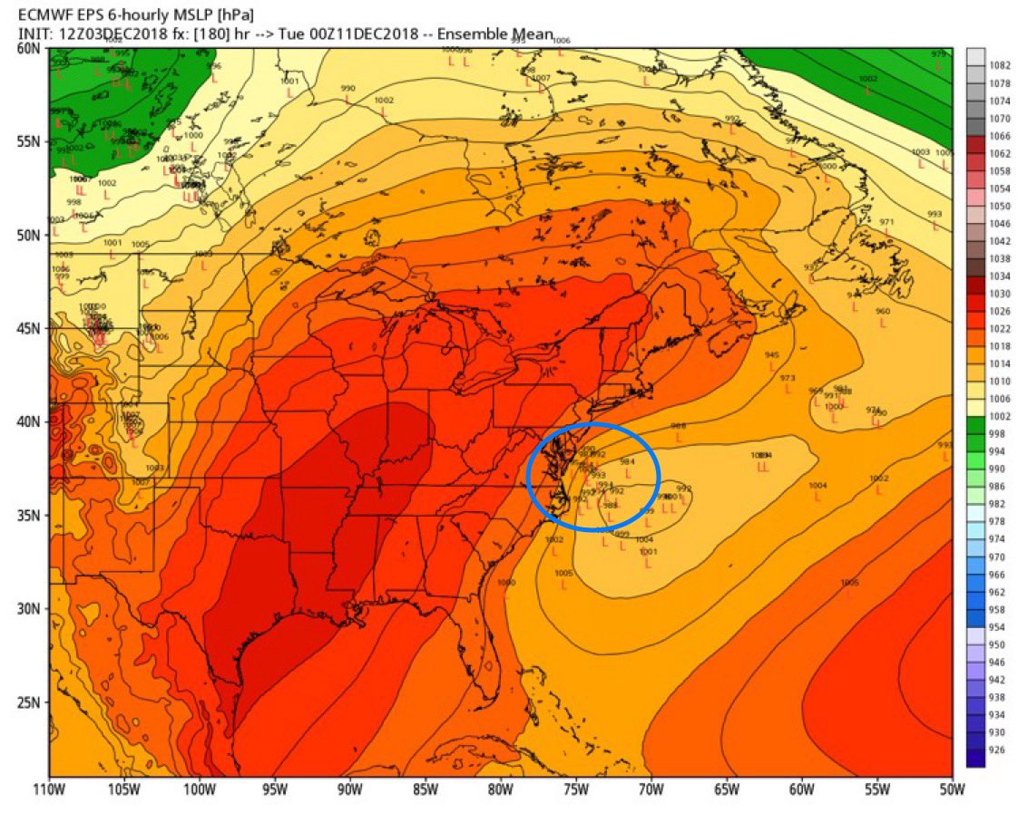
Look we still have 5 days and major changes can happen but one aspect that I am seeing is the suppressed heights that were in NE are now up in NE Canada.
Jman you complain its going to be rain because the 32* is not in your backyard I swear I'll put a ban on you from this storm LOL!! - don't worry about the 32* line this is just guidance for what is possible at this stage - thermal profiles are always skewed with dynamic and so many moving parts:

Here is the what JH pointed out in a write up about the energy lifting up and out - look at it over NE then at the end in SE Canada - this will allow the storm to gain North Latitude
 :
:From CCB at 33&Rain GIF he made of the FV3 - new PFS model 0 not much of change right? Only about 700 mile model error - I wish I had this in school i'd be a 150A+ student (if tehre was ever such a scale!!)

On a whole otehr note - the PV at the Stratosphere and Troposphere levels is getting whacked by major heat flux thus resulting in a would be elongation or even split as per the later and previous forecasts. This should start to take shape in affecting our weather by later December/early January.
This shows the major warming taking place and forecasted to:

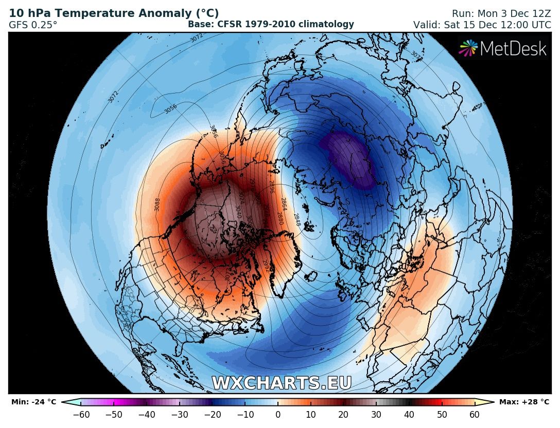
The DEC - FEB analog of 77-78, 02-03, 09-10 are good for this piece of winter with this Sudden Stratospheric Warming event.
Okay back to the chillins
_________________
Mugs
AKA:King: Snow Weenie
Self Proclaimed
WINTER 2014-15 : 55.12" +.02 for 6 coatings (avg. 35")
WINTER 2015-16 Total - 29.8" (Avg 35")
WINTER 2016-17 : 39.5" so far
amugs- Advanced Forecaster - Mod
- Posts : 15093
Reputation : 213
Join date : 2013-01-07
Age : 54
Location : Hillsdale,NJ
Re: Long Range Thread 17.0
![]() by bobjohnsonforthehall Tue Dec 04, 2018 9:45 am
by bobjohnsonforthehall Tue Dec 04, 2018 9:45 am

bobjohnsonforthehall- Posts : 311
Reputation : 19
Join date : 2016-10-02
Location : Flemington NJ
Re: Long Range Thread 17.0
![]() by Frank_Wx Tue Dec 04, 2018 10:32 am
by Frank_Wx Tue Dec 04, 2018 10:32 am

The good news...the confluence over New England has trended to lift sooner than expected.
_________________
_______________________________________________________________________________________________________
CLICK HERE to view NJ Strong Snowstorm Classifications

Frank_Wx- Godzilla Seeker

- Posts : 21305
Reputation : 328
Join date : 2013-01-05
Age : 31
Location : Jersey City, NJ -

rb924119- Meteorologist
- Posts : 6889
Reputation : 194
Join date : 2013-02-06
Age : 32
Location : Greentown, Pa

hyde345- Pro Enthusiast

- Posts : 1082
Reputation : 48
Join date : 2013-01-08
Location : Hyde Park, NY
Re: Long Range Thread 17.0
![]() by algae888 Tue Dec 04, 2018 11:48 am
by algae888 Tue Dec 04, 2018 11:48 am
algae888- Advanced Forecaster
- Posts : 5311
Reputation : 46
Join date : 2013-02-05
Age : 61
Location : mt. vernon, new york


Grselig- Senior Enthusiast
- Posts : 1408
Reputation : 140
Join date : 2013-03-04
Age : 54
Location : Wayne NJ
Re: Long Range Thread 17.0
![]() by rb924119 Tue Dec 04, 2018 12:35 pm
by rb924119 Tue Dec 04, 2018 12:35 pm
hyde345 wrote:Stick a fork in it.
HOLD YOUR FIRE!!!!!!! Lol it ain’t over yet.
rb924119- Meteorologist
- Posts : 6889
Reputation : 194
Join date : 2013-02-06
Age : 32
Location : Greentown, Pa
Re: Long Range Thread 17.0
![]() by algae888 Tue Dec 04, 2018 12:41 pm
by algae888 Tue Dec 04, 2018 12:41 pm
algae888- Advanced Forecaster
- Posts : 5311
Reputation : 46
Join date : 2013-02-05
Age : 61
Location : mt. vernon, new york
Page 15 of 41 • 1 ... 9 ... 14, 15, 16 ... 28 ... 41 ![]()
|
|
|