Long Range Thread 17.0
+40
Radz
lglickman1
Wheezer
aiannone
heehaw453
SENJsnowman
Scullybutcher
jake732
Sanchize06
larryrock72
bobjohnsonforthehall
SnowForest
hyde345
SoulSingMG
weatherwatchermom
MattyICE
GreyBeard
Smittyaj623
HectorO
Vinnydula
Nyi1058
jmanley32
CPcantmeasuresnow
Dunnzoo
algae888
skinsfan1177
Snow88
Quietace
rb924119
dkodgis
sroc4
docstox12
Grselig
amugs
Math23x7
billg315
nutleyblizzard
frank 638
mwilli5783
Frank_Wx
44 posters
Page 25 of 41
Page 25 of 41 •  1 ... 14 ... 24, 25, 26 ... 33 ... 41
 Re: Long Range Thread 17.0
THANK YOU!! for taking the time to explain it all to me....I appreciate it! Great explanation
weatherwatchermom- Senior Enthusiast

- Posts : 3743
Join date : 2014-11-25
 Re: Long Range Thread 17.0
Ditto that Mom! Plus thanks to you also for actually asking what me and I’m sure several others were thinking!
And sroc thanks so much for your brilliant beak down and generosity in time from all of you really
And sroc thanks so much for your brilliant beak down and generosity in time from all of you really
SENJsnowman- Senior Enthusiast

- Posts : 1186
Join date : 2017-01-06
 Re: Long Range Thread 17.0
CP What I should have said was Statistically speaking for most of the board coverage area there is a higher probability of sucking sucking than not; however, there have been times when it has not sucked or not sucked as bad. Depending on your exact geographic location the level of sucking, not sucking, or not sucking as bad is relative. This should be more clear.
_________________
"In weather and in life, there's no winning and losing; there's only winning and learning."
WINTER 2012/2013 TOTALS 43.65"WINTER 2017/2018 TOTALS 62.85" WINTER 2022/2023 TOTALS 4.9"
WINTER 2013/2014 TOTALS 64.85"WINTER 2018/2019 TOTALS 14.25" WINTER 2023/2024 TOTALS 13.1"
WINTER 2014/2015 TOTALS 71.20"WINTER 2019/2020 TOTALS 6.35"
WINTER 2015/2016 TOTALS 35.00"WINTER 2020/2021 TOTALS 37.75"
WINTER 2016/2017 TOTALS 42.25"WINTER 2021/2022 TOTALS 31.65"

sroc4- Admin

- Posts : 8331
Reputation : 301
Join date : 2013-01-07
Location : Wading River, LI

skinsfan1177- Senior Enthusiast

- Posts : 4485
Reputation : 35
Join date : 2013-01-07
Age : 46
Location : Point Pleasant Boro

CPcantmeasuresnow- Wx Statistician Guru

- Posts : 7274
Reputation : 230
Join date : 2013-01-07
Age : 103
Location : Eastern Orange County, NY

skinsfan1177- Senior Enthusiast

- Posts : 4485
Reputation : 35
Join date : 2013-01-07
Age : 46
Location : Point Pleasant Boro
 Re: Long Range Thread 17.0
Not sure when some of these models are supposed to start catching on with the change, but there's a lot of rain or just mixing in the future. Especially for the city, I feel sorry for them, all I see is rain for them.

HectorO- Pro Enthusiast

- Posts : 959
Reputation : 27
Join date : 2013-01-11
 Re: Long Range Thread 17.0
HectorO wrote:Not sure when some of these models are supposed to start catching on with the change, but there's a lot of rain or just mixing in the future. Especially for the city, I feel sorry for them, all I see is rain for them.
No way big cold outbreak coming

skinsfan1177- Senior Enthusiast

- Posts : 4485
Reputation : 35
Join date : 2013-01-07
Age : 46
Location : Point Pleasant Boro
 Re: Long Range Thread 17.0
sroc4 wrote:weatherwatchermom wrote:I know I should probably know what this map represents..but truthfully I don'tFrank_Wx wrote:


it must be good though
Momma. This image is of the 10mb level of the stratosphere which is the equivalent of approx. 15-16miles or 85,000feet above sea level. Just like when we show ridges and troughs at 500mb they exist at this level as well. The first image below is right now. Notice how the vortex is displaced on the wrong side of the globe. In the second image Very simply stated the red area circled over the arctic indicates the stratospheric warming event taking place; the result of which has cause the stratospheric vortex to split into two lobes, one of which displaces over north America. THIS IS GOOD. The other important thing this warming event does is weakens the vortex. The reason being is that it weakens the temp gradient. Just like the jet streams down closer to earth the wind moves in large part due to the temp gradients between the lower latitudes and higher latitudes. When the strat temps are cold there is a much larger temp difference between the air over the arctic vs the equator. The result is much tighter gradient and and much stronger faster circulating vortex. This acts like a noose trapping cold air in the higher latitudes. When a sudden stratospheric warming event occurs, it effectively brings the temp gradient prev discussed closer which effectively weakens the movement of air slowing it down; weakens the noose if you will. Now this is the first part.
So with a weakened noose lets examine the warming of the strat a little further. This will be overly simplified but should be easy to understand. Now Picture turning our view of the strat horizontally:
We now have a weaker noose. Now picture the arctic air and polar masses like a balloon sitting centered on the N pole. Above the baloon is the stratosphere. Ok so A massive warming just took place. What happens to the air molecules at any level when they warm? The air expands right? As air warms the molecues get more excited and spread out; as they cool they condense and become more dense. If you cant follow take an empty water bottole with a cap on it at room temp and put it in the freezer. after a few hrs the bottle will appear to have collapsed on itself. Then take it out and put it next to the heater. After a few hrs here you will see it expand as the pressure builds. Anyway back the the strat. When a large area of air at the level of the strat warms like this the air will do the same thing, expand. Since the strat is so high up in the atmosphere and almost "in space" the expanding air has an easier time expanding downward rather than up into space. As it does so it pushes on the "balloon" of arctic and polar air. Picture placing a small balloon on a globe in your house. Now pretend your fist is the strat. Now push your fist down slowly over the center of the balloon. This represents the expanding stratospheric air pressing down on the tropspheric air(where we live). What happens? As you press down on the balloon the balloon spreads out and drifts southward into the mid lattitudes of your globe right? This is essence, and very very simply stated, is what happens when the strat warms.
The strat warms which loosens the grip on the cold air. As it expands it presses down on the troposphere allowing the discharge of cold air masses south into the mid latitudes.
Momma thatis essentiall what the image Frank posted is showing. A serious strat warming that weakens and almost obliterates its overall structure, such that it splits into two smaller vorticies. This WILL set us up very nicely for a long stretch in Jan should it verify. Yes that static image is 240hrs away but as I mentioned in prev posts what everyone is complaining about now is actually the precursor to what you see in that image. The wheels have already been set in motion. Here was the quote from the9th write up: Ironically its the less than ideal/crappy next 10-14days that seems to be the precursor to such an event. So like taking medicine we will have to swallow it reluctantly; however, knowing that after the course of medicine is finished healthier times lie ahead.
This IS happening. This WILL set us up nicely as we head into 2019. We STILL have a shot at a white Christmas. I CONTINE to choose the OPTIMISTIC approach. SO WHAT that Dec sucked. Statistically it always sucks. Get over it
Scott, this post should be archived in the educational section. PHENOMENAL explanation!
rb924119- Meteorologist

- Posts : 6890
Reputation : 194
Join date : 2013-02-06
Age : 32
Location : Greentown, Pa
 Re: Long Range Thread 17.0
Thanks Ray...done
_________________
"In weather and in life, there's no winning and losing; there's only winning and learning."
WINTER 2012/2013 TOTALS 43.65"WINTER 2017/2018 TOTALS 62.85" WINTER 2022/2023 TOTALS 4.9"
WINTER 2013/2014 TOTALS 64.85"WINTER 2018/2019 TOTALS 14.25" WINTER 2023/2024 TOTALS 13.1"
WINTER 2014/2015 TOTALS 71.20"WINTER 2019/2020 TOTALS 6.35"
WINTER 2015/2016 TOTALS 35.00"WINTER 2020/2021 TOTALS 37.75"
WINTER 2016/2017 TOTALS 42.25"WINTER 2021/2022 TOTALS 31.65"

sroc4- Admin

- Posts : 8331
Reputation : 301
Join date : 2013-01-07
Location : Wading River, LI

skinsfan1177- Senior Enthusiast

- Posts : 4485
Reputation : 35
Join date : 2013-01-07
Age : 46
Location : Point Pleasant Boro
 Re: Long Range Thread 17.0
Models cont to trend better for Christmas eve for some mood flakes. A coating to an inch is a def possibility for many.


_________________
"In weather and in life, there's no winning and losing; there's only winning and learning."
WINTER 2012/2013 TOTALS 43.65"WINTER 2017/2018 TOTALS 62.85" WINTER 2022/2023 TOTALS 4.9"
WINTER 2013/2014 TOTALS 64.85"WINTER 2018/2019 TOTALS 14.25" WINTER 2023/2024 TOTALS 13.1"
WINTER 2014/2015 TOTALS 71.20"WINTER 2019/2020 TOTALS 6.35"
WINTER 2015/2016 TOTALS 35.00"WINTER 2020/2021 TOTALS 37.75"
WINTER 2016/2017 TOTALS 42.25"WINTER 2021/2022 TOTALS 31.65"

sroc4- Admin

- Posts : 8331
Reputation : 301
Join date : 2013-01-07
Location : Wading River, LI
 Re: Long Range Thread 17.0
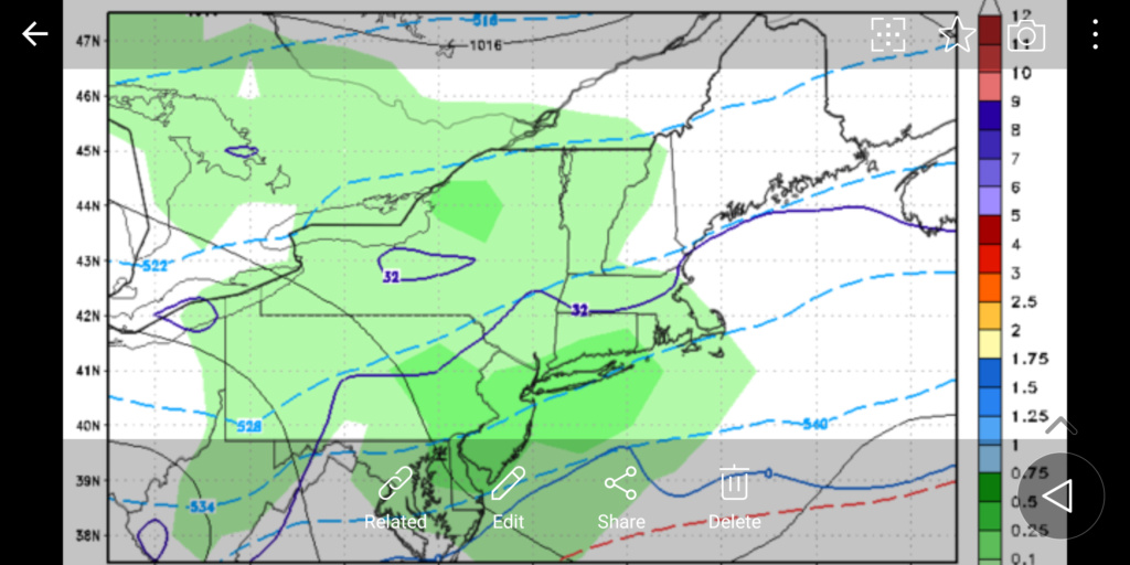
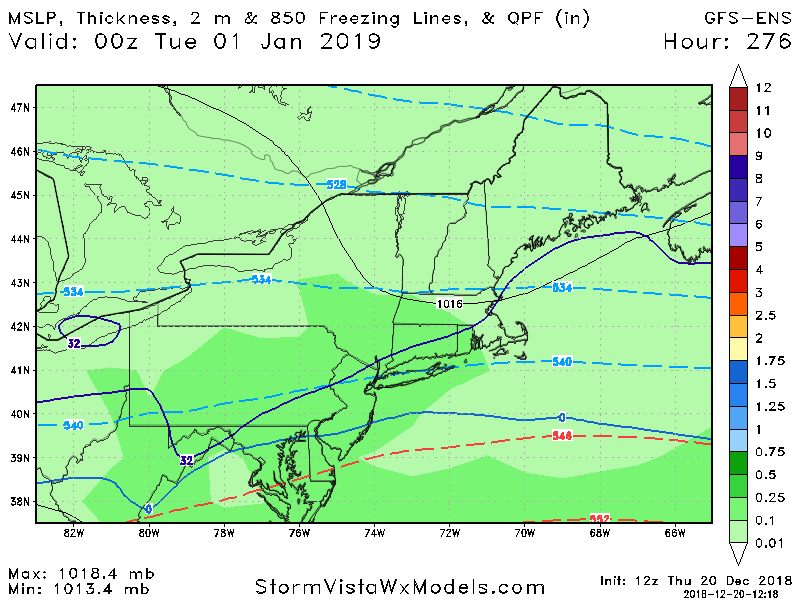
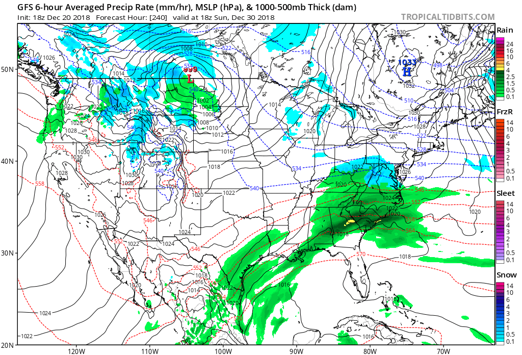
Ensembles are beginning to hint at the pattern change. It looks like December 30th to January 2nd is the "transitional" time period. There could be a big coastal storm around this time, however, since the pattern is in transition I'm not sold on the snow aspect just yet.
January 3rd to January 5th is when the pattern moves from its transitional stage to its "adult" stage. It has the potential to last all the way through January 20th. A +PNA/-AO/-NAO will be how it starts off. The -NAO will be east-based at first, then gradually become west-based as we get deeper into January. The PNA will not get positive until the pesky MJO wave fully decomposes. Once that tropical wave dies the EPO and PNA regions should turn favorable and El Nino / +PDO should take over.
We're looking at major changes beginning after January 3rd.
_________________
_______________________________________________________________________________________________________
CLICK HERE to view NJ Strong Snowstorm Classifications
 Re: Long Range Thread 17.0
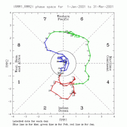
In the pattern change thread Mike brought up the MJO. I mentioned how the MJO, even though unfavorable and leading to a non-winter pattern for us, is HELPING the warming in the Stratosphere. During the February 2001 SSWE, the MJO was also in phase 5.

_________________
_______________________________________________________________________________________________________
CLICK HERE to view NJ Strong Snowstorm Classifications

skinsfan1177- Senior Enthusiast

- Posts : 4485
Reputation : 35
Join date : 2013-01-07
Age : 46
Location : Point Pleasant Boro
 Re: Long Range Thread 17.0
No ones fault but now we gotta wait till the first week of Januarypotentially. Another 10 days. Let’s hope this is the last “delay” because ......................
Guest- Guest
 Re: Long Range Thread 17.0
syosnow94 wrote:No ones fault but now we gotta wait till the first week of Januarypotentially. Another 10 days. Let’s hope this is the last “delay” because ......................
For the locking in of the pattern change..not for snow chances
_________________
"In weather and in life, there's no winning and losing; there's only winning and learning."
WINTER 2012/2013 TOTALS 43.65"WINTER 2017/2018 TOTALS 62.85" WINTER 2022/2023 TOTALS 4.9"
WINTER 2013/2014 TOTALS 64.85"WINTER 2018/2019 TOTALS 14.25" WINTER 2023/2024 TOTALS 13.1"
WINTER 2014/2015 TOTALS 71.20"WINTER 2019/2020 TOTALS 6.35"
WINTER 2015/2016 TOTALS 35.00"WINTER 2020/2021 TOTALS 37.75"
WINTER 2016/2017 TOTALS 42.25"WINTER 2021/2022 TOTALS 31.65"

sroc4- Admin

- Posts : 8331
Reputation : 301
Join date : 2013-01-07
Location : Wading River, LI
 Re: Long Range Thread 17.0
Do not look past the currently modeled cutter around the 27th -28th. There is some pretty strong HP being modeled to the N over the GL and in NW Canada with some higher heights into Greenland. There is a chance that this trends more like a transfer nearer the coast instead of central Canada with cold air damning (CAD) and front end thump potential.
_________________
"In weather and in life, there's no winning and losing; there's only winning and learning."
WINTER 2012/2013 TOTALS 43.65"WINTER 2017/2018 TOTALS 62.85" WINTER 2022/2023 TOTALS 4.9"
WINTER 2013/2014 TOTALS 64.85"WINTER 2018/2019 TOTALS 14.25" WINTER 2023/2024 TOTALS 13.1"
WINTER 2014/2015 TOTALS 71.20"WINTER 2019/2020 TOTALS 6.35"
WINTER 2015/2016 TOTALS 35.00"WINTER 2020/2021 TOTALS 37.75"
WINTER 2016/2017 TOTALS 42.25"WINTER 2021/2022 TOTALS 31.65"

sroc4- Admin

- Posts : 8331
Reputation : 301
Join date : 2013-01-07
Location : Wading River, LI
 Re: Long Range Thread 17.0
Exactly Scott I've been noticing that to Big Trend today on the 6z GFS and the 12z icon Euro had it a few runs ago we'll see how it looks in a few days but definitely strong CAD signal theresroc4 wrote:Do not look past the currently modeled cutter around the 27th -28th. There is some pretty strong HP being modeled to the N over the GL and in NW Canada with some higher heights into Greenland. There is a chance that this trends more like a transfer nearer the coast instead of central Canada with cold air damning (CAD) and front end thump potential.

algae888- Advanced Forecaster

- Posts : 5311
Reputation : 46
Join date : 2013-02-05
Age : 61
Location : mt. vernon, new york
 Re: Long Range Thread 17.0
Scott ukie has a 1039mb hp over northerh ny with cad down thru the carolinas at hour 144. 1000 mb low over oklahoma pan handle. Much different than the gfs.

algae888- Advanced Forecaster

- Posts : 5311
Reputation : 46
Join date : 2013-02-05
Age : 61
Location : mt. vernon, new york
 Re: Long Range Thread 17.0
algae888 wrote:Scott ukie has a 1039mb hp over northerh ny with cad down thru the carolinas at hour 144. 1000 mb low over oklahoma pan handle. Much different than the gfs.
I saw that. Still have work to do but you can see the possibility. Id like to see the higher heights in the Greenland area trend a little stronger which will help to anchor that HP even further, enough to deflect the energy to the coast. Also Id like to see the main LP cutting cont to trend weaker, which it has already. We want a weaker primary.
_________________
"In weather and in life, there's no winning and losing; there's only winning and learning."
WINTER 2012/2013 TOTALS 43.65"WINTER 2017/2018 TOTALS 62.85" WINTER 2022/2023 TOTALS 4.9"
WINTER 2013/2014 TOTALS 64.85"WINTER 2018/2019 TOTALS 14.25" WINTER 2023/2024 TOTALS 13.1"
WINTER 2014/2015 TOTALS 71.20"WINTER 2019/2020 TOTALS 6.35"
WINTER 2015/2016 TOTALS 35.00"WINTER 2020/2021 TOTALS 37.75"
WINTER 2016/2017 TOTALS 42.25"WINTER 2021/2022 TOTALS 31.65"

sroc4- Admin

- Posts : 8331
Reputation : 301
Join date : 2013-01-07
Location : Wading River, LI
 Re: Long Range Thread 17.0
I've been harping on new years for a snowstorm for awhile. I believe it's the best setup we have seen so far. I like the - nao showing up consistently on models. Only thing I want to see change in is the SW fort eject quicker and not be held back. Not sure if that's a gfs model bias or not.

skinsfan1177- Senior Enthusiast

- Posts : 4485
Reputation : 35
Join date : 2013-01-07
Age : 46
Location : Point Pleasant Boro
 Re: Long Range Thread 17.0
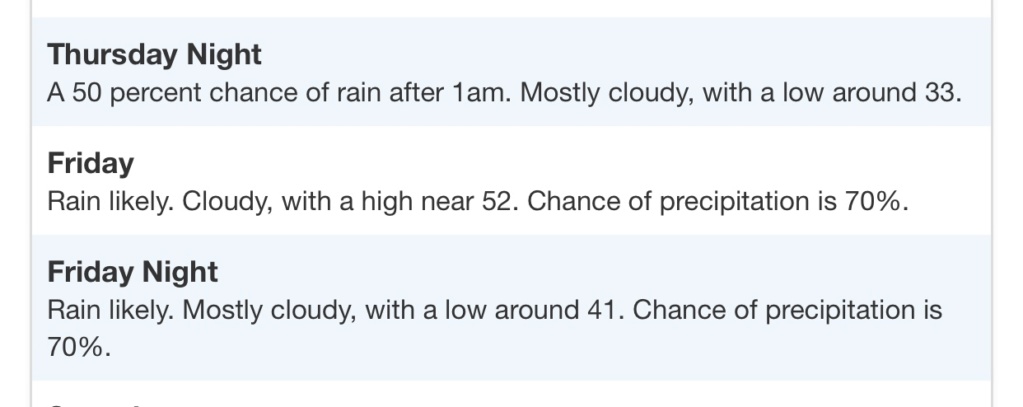
5 days out. Not super LR anymore. NWS has rainand temps in the mid to upper 40s FOR THE CATSKILLS. Considering that is further N then 99.8% of this entire forum, this DOES NOT LOOK PROMISING AT ALL
Guest- Guest
 Re: Long Range Thread 17.0
syosnow94 wrote:5 days out. Not super LR anymore. NWS has rainand temps in the mid to upper 40s FOR THE CATSKILLS. Considering that is further N then 99.8% of this entire forum, this DOES NOT LOOK PROMISING AT ALL
Pretty dismal for sure. NYE & NYD does show promise but to far off to get excited.

CPcantmeasuresnow- Wx Statistician Guru

- Posts : 7274
Reputation : 230
Join date : 2013-01-07
Age : 103
Location : Eastern Orange County, NY
 Re: Long Range Thread 17.0
sroc4 wrote:algae888 wrote:Scott ukie has a 1039mb hp over northerh ny with cad down thru the carolinas at hour 144. 1000 mb low over oklahoma pan handle. Much different than the gfs.
I saw that. Still have work to do but you can see the possibility. Id like to see the higher heights in the Greenland area trend a little stronger which will help to anchor that HP even further, enough to deflect the energy to the coast. Also Id like to see the main LP cutting cont to trend weaker, which it has already. We want a weaker primary.
I’m so fired up for this later this week. Anybody else?
Guest- Guest
 Re: Long Range Thread 17.0
So am I I love the rain lol can we please get a snowstorm already
frank 638- Senior Enthusiast

- Posts : 2825
Reputation : 37
Join date : 2016-01-01
Age : 40
Location : bronx ny
 Re: Long Range Thread 17.0
frank 638 wrote:So am I I love the rain lol can we please get a snowstorm already
The potential around new years can produce snow and let's not worry about the rain/snow line yet what's key is the storm has been their for over a week

skinsfan1177- Senior Enthusiast

- Posts : 4485
Reputation : 35
Join date : 2013-01-07
Age : 46
Location : Point Pleasant Boro
Page 25 of 41 •  1 ... 14 ... 24, 25, 26 ... 33 ... 41
Page 25 of 41
Permissions in this forum:
You cannot reply to topics in this forum|
|
|

 Home
Home