
 Search
Long Range Thread 17.0
Page 26 of 41 •  1 ... 14 ... 25, 26, 27 ... 33 ... 41
 ![]()
Re: Long Range Thread 17.0
![]() by frank 638 Sun Dec 23, 2018 10:31 pm
by frank 638 Sun Dec 23, 2018 10:31 pm
frank 638- Senior Enthusiast

- Posts : 2824
Join date : 2016-01-01
Re: Long Range Thread 17.0
![]() by skinsfan1177 Mon Dec 24, 2018 7:59 am
by skinsfan1177 Mon Dec 24, 2018 7:59 am
frank 638 wrote:So am I I love the rain lol can we please get a snowstorm already
The potential around new years can produce snow and let's not worry about the rain/snow line yet what's key is the storm has been their for over a week
skinsfan1177- Senior Enthusiast
- Posts : 4485
Join date : 2013-01-07
Re: Long Range Thread 17.0
![]() by billg315 Mon Dec 24, 2018 11:22 am
by billg315 Mon Dec 24, 2018 11:22 am

billg315- Advanced Forecaster - Mod

- Posts : 4462
Reputation : 185
Join date : 2015-01-24
Age : 50
Location : Flemington, NJ
Re: Long Range Thread 17.0
![]() by algae888 Mon Dec 24, 2018 11:35 am
by algae888 Mon Dec 24, 2018 11:35 am
I like the time frame to but actually have no idea what's going to happen. Models are all over the place. it seems that the ensembles want to drop energy into the Southwest in response to the EPO Ridge and the way it's oriented any system out there that gets wound up will most likely cut unless we get strong Confluence to our North. What we really want is a weaker system with a lot of juice from the Gulf of Mexico and get an over running event. I think that's our best shot in this timeframe but we will seebillg315 wrote:I (like Skins) continue to like the looks of things around 12/31 and 1/4. Temp setup is looking good, storm track is modeling to our south and east finally (instead of our west like last Friday and this Friday). I think one or both of these time frames yield a significant snow event.

algae888- Advanced Forecaster

- Posts : 5311
Reputation : 46
Join date : 2013-02-05
Age : 61
Location : mt. vernon, new york
Re: Long Range Thread 17.0
![]() by skinsfan1177 Mon Dec 24, 2018 11:55 am
by skinsfan1177 Mon Dec 24, 2018 11:55 am

skinsfan1177- Senior Enthusiast
- Posts : 4485
Reputation : 35
Join date : 2013-01-07
Age : 46
Location : Point Pleasant Boro
Re: Long Range Thread 17.0
![]() by billg315 Tue Dec 25, 2018 9:44 am
by billg315 Tue Dec 25, 2018 9:44 am
billg315- Advanced Forecaster - Mod
- Posts : 4462
Reputation : 185
Join date : 2015-01-24
Age : 50
Location : Flemington, NJ
Re: Long Range Thread 17.0
![]() by skinsfan1177 Tue Dec 25, 2018 4:00 pm
by skinsfan1177 Tue Dec 25, 2018 4:00 pm
billg315 wrote:The GFS still has the 12/30-31 storm with the rain/snow line being the question mark. The disturbance it depicts around the 1/3-5 time frame now slides to our south. The modeled flow seems too zonal/flat to kick it up the coast or to the Mid-Atlantic. Not sure that will stay the case as we get closer. And frankly, with all the cutters we’ve had, I feel better with the models starting to miss to our south this far out than I would if they were missing to our west.
I believe the se ridge will be our friend and bring the storm up
skinsfan1177- Senior Enthusiast
- Posts : 4485
Reputation : 35
Join date : 2013-01-07
Age : 46
Location : Point Pleasant Boro
Re: Long Range Thread 17.0
![]() by aiannone Tue Dec 25, 2018 4:05 pm
by aiannone Tue Dec 25, 2018 4:05 pm
_________________
-Alex Iannone-

aiannone- Senior Enthusiast - Mod
- Posts : 4813
Reputation : 92
Join date : 2013-01-07
Location : Saint James, LI (Northwest Suffolk Co.)
Re: Long Range Thread 17.0
![]() by SENJsnowman Wed Dec 26, 2018 3:43 pm
by SENJsnowman Wed Dec 26, 2018 3:43 pm
I was wondering if maybe one or two of you could weigh in as to whether you put any stock in the rule, either generally or as it pertains to the next 2-3 weeks?
Thanks.
SENJsnowman- Senior Enthusiast
- Posts : 1186
Reputation : 61
Join date : 2017-01-06
Age : 51
Location : Bayville, NJ
Re: Long Range Thread 17.0
![]() by HectorO Wed Dec 26, 2018 4:06 pm
by HectorO Wed Dec 26, 2018 4:06 pm
SENJsnowman wrote:On another page I just saw an admin discuss the Bering Sea Rule and that it indicates a 'wintry precip' for north of M-D line Jan 2-3.
I was wondering if maybe one or two of you could weigh in as to whether you put any stock in the rule, either generally or as it pertains to the next 2-3 weeks?
Thanks.
Frank mentioned something possibly happening in that time frame already.

HectorO- Pro Enthusiast

- Posts : 959
Reputation : 27
Join date : 2013-01-11
Re: Long Range Thread 17.0
![]() by SENJsnowman Wed Dec 26, 2018 4:26 pm
by SENJsnowman Wed Dec 26, 2018 4:26 pm
HectorO wrote:SENJsnowman wrote:On another page I just saw an admin discuss the Bering Sea Rule and that it indicates a 'wintry precip' for north of M-D line Jan 2-3.
I was wondering if maybe one or two of you could weigh in as to whether you put any stock in the rule, either generally or as it pertains to the next 2-3 weeks?
Thanks.
Frank mentioned something possibly happening in that time frame already.
Thanks for the response, Hector. I saw that too, I was wondering more specifically about the BSR and what it might be indicating for that time frame and if that is worth anything anyways.
SENJsnowman- Senior Enthusiast
- Posts : 1186
Reputation : 61
Join date : 2017-01-06
Age : 51
Location : Bayville, NJ

Guest- Guest
Re: Long Range Thread 17.0
![]() by jmanley32 Thu Dec 27, 2018 12:48 am
by jmanley32 Thu Dec 27, 2018 12:48 am
What!! This Friday! Another 1-2 inches of rain for f sake!!syosnow94 wrote:This says it all. Happy New Year all.

jmanley32- Senior Enthusiast
- Posts : 20513
Reputation : 108
Join date : 2013-12-12
Age : 42
Location : Yonkers, NY
Re: Long Range Thread 17.0
![]() by HectorO Thu Dec 27, 2018 7:37 am
by HectorO Thu Dec 27, 2018 7:37 am
jmanley32 wrote:What!! This Friday! Another 1-2 inches of rain for f sake!!syosnow94 wrote:This says it all. Happy New Year all.
Yea man, the grounds are so saturated where I live it's causing basements to spring leaks in all the houses. Front and back yards when it rains just puddles up because there's nowhere for the moisture to go anymore. Mother nature truly is a you know what. I wish we could have gift wrapped half of this moisture we've had since June and given it to southern cali.
HectorO- Pro Enthusiast
- Posts : 959
Reputation : 27
Join date : 2013-01-11
Re: Long Range Thread 17.0
![]() by SENJsnowman Thu Dec 27, 2018 7:57 am
by SENJsnowman Thu Dec 27, 2018 7:57 am
SENJsnowman- Senior Enthusiast
- Posts : 1186
Reputation : 61
Join date : 2017-01-06
Age : 51
Location : Bayville, NJ
Re: Long Range Thread 17.0
![]() by skinsfan1177 Thu Dec 27, 2018 8:12 am
by skinsfan1177 Thu Dec 27, 2018 8:12 am
skinsfan1177- Senior Enthusiast
- Posts : 4485
Reputation : 35
Join date : 2013-01-07
Age : 46
Location : Point Pleasant Boro
Re: Long Range Thread 17.0
![]() by Guest Thu Dec 27, 2018 10:33 am
by Guest Thu Dec 27, 2018 10:33 am
skinsfan1177 wrote:I'm going to be honest their is nothing good about the first 10 days of January. The phase 5 mjo is killing us
SHOCKING. This will put us 2 full months without snow since the 11/16 storm during an “epic” season!
Guest- Guest
Re: Long Range Thread 17.0
![]() by Frank_Wx Thu Dec 27, 2018 10:44 am
by Frank_Wx Thu Dec 27, 2018 10:44 am

Those are some serious storms. They have trained over those islands for days. As a reminder, here are the phases of the MJO overlaid on a map:

The area within my purple box - where all the storms are - corresponds nicely to show the MJO is in phase 5. The tropical wave associated with these storms is slowly moving east into phase 6 of the MJO. That is also shown on the Hovmoller map, where the red color represents westerly zonal wind anomalies.
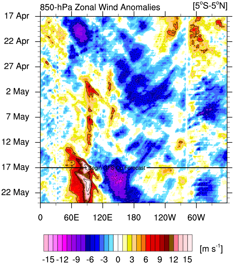
Notice that the greatest anomalies (brown color) is between 120E and 150E. The GFS forecast actually looks kinda split. It continues to show westerly wind bursts, or areas of convection, at 120E through January 3rd which would keep the MJO in phase 5. But it also shows positive anomalies toward 160E which is phase 7 of the MJO. I am wondering if this is 1 tropical wave with "pieces" of convection breaking off and moving east, or is it a bunch of waves that are seriously disrupting the pattern.
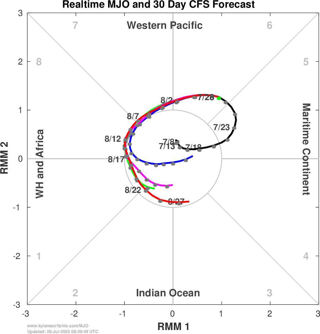
The CFS (top image) and GFS (bottom image) are alike. They both show the MJO currently in mid to high amplitude phase 5, which matches current observations I've already shown. They both then take the MJO into phase 6 by January 1st and phase 7 by January 7th. It is worth pointing out these models not only continue to propagate the MJO east, but it is in very high amplitudes of phases 6 and 7.

The EURO, on the other hand, only agrees with the CFS/GFS that the MJO is currently in mid amplitude phase 5. It then takes the MJO into low amplitudes of phases 5 and 6 before dying off into the COD. This is a significant difference from what the other 2 models show.
An MJO in phase 6 with an El Nino base state historically brings this type of 500mb pattern to the CONUS:

And here is phase 7:

I mine as well show phase 8:

What's interesting is - if the CFS/GFS are correct - there will be high latitude blocking developing over the Arctic regions around January 6th/7th. We can't forget about the Sudden Stratospheric Warming Event already taking place. The effects of the SSWE should begin to transcend down to the Troposphere around the same time frame. In fact, changes to our pattern have already occurred. You can't use snowfall as a factor to judge a pattern change. You have to look at the leading indicators that actually drive the pattern to change.
Moral of the story is this:
The pattern has already changed from where it was most of December when Canada was running +10 degrees above normal. This is a very slow evolution that is going to take time and patience, of which most of you seem to not have. There will be snow chances through January 6th, but nothing looks too promising at the moment. I think for me we need to see what the MJO actually decides to do and how that corresponds with the changes happening at the Stratosphere. I'm not sure anyone has an answer right now. But if you want to believe the GFS/CFS, then look for major changes to happen by the 2nd week of January.
I understand the frustration right now. We could be 6 weeks into Meteorological Winter with nothing of significance. Let's hope the positive news we're seeing with regards to the Stratosphere and maybe the MJO bring us fortune for the 2nd half of this winter.
_________________
_______________________________________________________________________________________________________
CLICK HERE to view NJ Strong Snowstorm Classifications

Frank_Wx- Godzilla Seeker

- Posts : 21305
Reputation : 328
Join date : 2013-01-05
Age : 31
Location : Jersey City, NJ -

Re: Long Range Thread 17.0
![]() by Wheezer Thu Dec 27, 2018 11:50 am
by Wheezer Thu Dec 27, 2018 11:50 am
Wheezer- Posts : 30
Reputation : 6
Join date : 2017-11-08
Location : Cincinnati, Oh
Re: Long Range Thread 17.0
![]() by Guest Thu Dec 27, 2018 12:04 pm
by Guest Thu Dec 27, 2018 12:04 pm
Guest- Guest
Re: Long Range Thread 17.0
![]() by rb924119 Thu Dec 27, 2018 1:05 pm
by rb924119 Thu Dec 27, 2018 1:05 pm
This is for everybody, and not solely you, Frank, but I’d like you (all) to revisit the Hovmoeller diagram, and tell me what you notice about our convection.....the present is not all that matters here (hint hint). I’ll let you guys ponder this a bit, but I WILL reveal what I’m getting at later this evening/early tomorrow morning. I want to see if anybody figures out what has transpired recently on their own, before I just give it away - this is an educational board too, right?
rb924119- Meteorologist

- Posts : 6889
Reputation : 194
Join date : 2013-02-06
Age : 32
Location : Greentown, Pa
Re: Long Range Thread 17.0
![]() by SENJsnowman Thu Dec 27, 2018 1:21 pm
by SENJsnowman Thu Dec 27, 2018 1:21 pm
Math23x7 wrote:
Also, take a look at the MJO projections, The ECMWF shows it going from Phase 5 to 6/neutral (still warm phase) and the GEFS keeps it in Phase 5 through New Year's.
Of course, the SSW map at 3:19 in the video is somewhat similar to the one Frank posted today, but the other components arent cooperating at the moment.
If they don't get their act together in the next few weeks, winter is in big trouble.
Still hate the message, but this messenger saw it coming and said so. Good job Math!
SENJsnowman- Senior Enthusiast
- Posts : 1186
Reputation : 61
Join date : 2017-01-06
Age : 51
Location : Bayville, NJ
Re: Long Range Thread 17.0
![]() by CPcantmeasuresnow Thu Dec 27, 2018 4:50 pm
by CPcantmeasuresnow Thu Dec 27, 2018 4:50 pm
SENJsnowman wrote:Anybody remember this post from December 18:Math23x7 wrote:
Also, take a look at the MJO projections, The ECMWF shows it going from Phase 5 to 6/neutral (still warm phase) and the GEFS keeps it in Phase 5 through New Year's.
Of course, the SSW map at 3:19 in the video is somewhat similar to the one Frank posted today, but the other components arent cooperating at the moment.
If they don't get their act together in the next few weeks, winter is in big trouble.
Still hate the message, but this messenger saw it coming and said so. Good job Math!
I give Math credit and he makes some excellent points at times, but he is a known and outspoken Warmacist so he does have a bias in all of his posts. You have to keep that in mind when you read his posts.

CPcantmeasuresnow- Wx Statistician Guru

- Posts : 7274
Reputation : 230
Join date : 2013-01-07
Age : 103
Location : Eastern Orange County, NY
Re: Long Range Thread 17.0
![]() by Guest Thu Dec 27, 2018 6:52 pm
by Guest Thu Dec 27, 2018 6:52 pm
Guest- Guest
Re: Long Range Thread 17.0
![]() by heehaw453 Thu Dec 27, 2018 7:00 pm
by heehaw453 Thu Dec 27, 2018 7:00 pm
https://www.americanwx.com/bb/topic/51698-my-winter-outlook-2018-19/?do=findComment&comment=5080950
heehaw453- Advanced Forecaster
- Posts : 3906
Reputation : 86
Join date : 2014-01-20
Location : Bedminster Township, PA Elevation 600' ASL
Re: Long Range Thread 17.0
![]() by Guest Thu Dec 27, 2018 8:26 pm
by Guest Thu Dec 27, 2018 8:26 pm
NOT TRYING TO BE A DOUCHE).
He can claim to be a perfectionist as much as he wants. All his 10 bullet points add up to the following
I NEVER said this winter would be a blockbuster. (Kind of False you predicted 133%+ above normal snow)
No one including myself ever saw this happening therefore I’m off the hook False again. (Math did and he’s not a forecaster).
There are two months left and even though they not not the same ones I predicted they COULD still be above normal snow and cold in which case my forecast would verify. ( false again).
This guy is MUCH more scientifically schooled and knowledgeable than I am but CMON......
Guest- Guest
Re: Long Range Thread 17.0
![]() by docstox12 Fri Dec 28, 2018 3:13 am
by docstox12 Fri Dec 28, 2018 3:13 am
syosnow94 wrote:But he was right CP. and we have other actual forecasts with the opposite bias that were wrong. Just sayin’
Exactly! Math was the voice crying in the wilderness at the time,LOL.The preponderance of opinion was against his projection.Gotta give credit where it is due!

docstox12- Wx Statistician Guru
- Posts : 8502
Reputation : 222
Join date : 2013-01-07
Age : 73
Location : Monroe NY
Page 26 of 41 • 1 ... 14 ... 25, 26, 27 ... 33 ... 41 ![]()
|
|
|