JANUARY 28th Storm Potential
+8
GreyBeard
larryrock72
Irish
algae888
SENJsnowman
heehaw453
billg315
sroc4
12 posters
 JANUARY 28th Storm Potential
Im starting a thread for this one because the long range does have a parade of threats, some better than others, so lets keep things organized.
As of this writing the scroll above states that as currently modeled this threat has mothrazilla potential for points to our south. But here is the thing with this system...IF we see a trend for the storm track to trend more NE ward relative to what we are seeing now there will be changes to the ceiling of the potential for this system. These changes will likely be proportional to the steepness(NNE) or progressiveness(ENE) to the track relative to the coast. Mothrazilla could easily turn into Godzilla for some if the storm track gains latitude. The reasoning for this lies in the upper levels. If the changes in the upper levels occur that would allow this storm to come up then there will be changes/enhancement to the vertical lifting mechanisms thereby increasing total QPF amounts in certain areas relative to the storm track. The southern portion of our coverage area would most likely be the beneficiary to such changes. BUT keep in mind with stronger storms you get stronger dynamics. With stronger dynamics comes a more distinct boundary between the warm and the cold. Of course there are many factors govern these details; however.
Lets put some pictures with the words to better understand the basic idea of what's governing this set up.
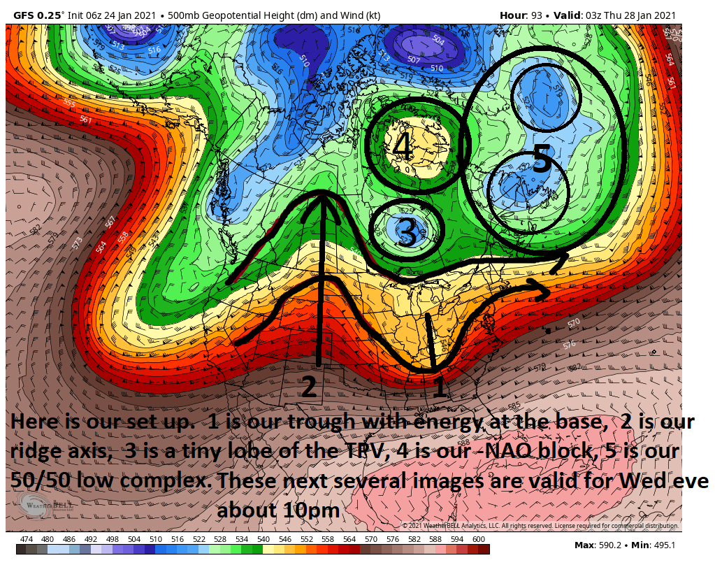
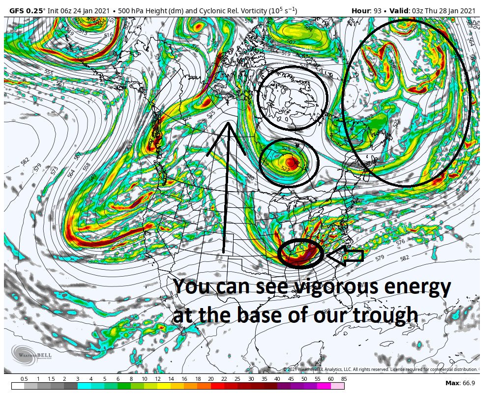

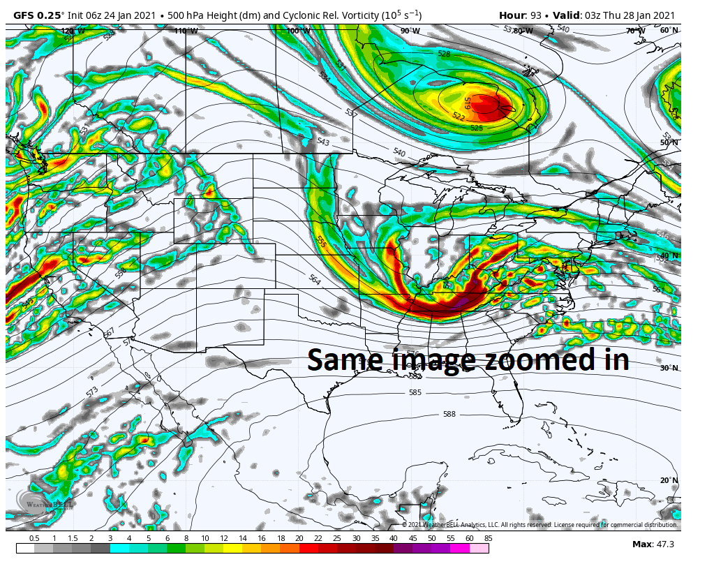

Lets get back to this image again and zoom in.


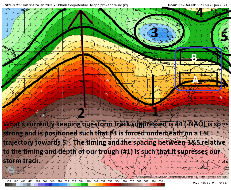
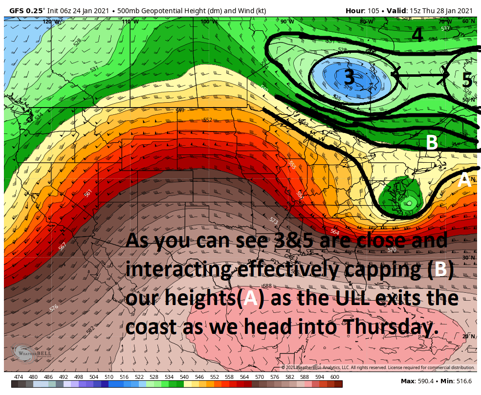

So Unfort IMHO the pattern is such that a more suppressed storm track is the most likely scenario, but areas as far north as the I95 along the CT coast should def keep on alert for any subtle shifts and from Atlantic city on southward are def in the game.
Here are a few scenarios either on their own or in combination that could allow for a more NEward shift to the storm track:
1) amplify 2 and 1 will dig more. If you dig the energy in 1 further south you amplify the trough. Picture two people holding opposite ends of a rubber band. You take your finger and push down in the middle of the rubber band. The more you push down in the middle the steeper the sides become.
2) if we can space out the distance between 3&5 a little ie: shift 5 east, then you have room for B to up effectively raising the ceiling to how high A can amplify as it reaches the coast.
3) If we can position 3 a tad further NW, W, or SW again we can increase the space between 3&5 effectively leaving room for our ceiling/Cap to increase allowing A to go up etc.
Again Ill reiterate or beat the dead horse; the pattern seems to me to suggest that a more suppressed track effectively taking most of our coverage area out of the main equation but thre are enough southern areas definitely in play here AND there is still plenty of lead time to see our models continue to evolve the situation....for better (up the coast) OR worse (even more suppressed.
So.......WE TRACK!!!!!!
As of this writing the scroll above states that as currently modeled this threat has mothrazilla potential for points to our south. But here is the thing with this system...IF we see a trend for the storm track to trend more NE ward relative to what we are seeing now there will be changes to the ceiling of the potential for this system. These changes will likely be proportional to the steepness(NNE) or progressiveness(ENE) to the track relative to the coast. Mothrazilla could easily turn into Godzilla for some if the storm track gains latitude. The reasoning for this lies in the upper levels. If the changes in the upper levels occur that would allow this storm to come up then there will be changes/enhancement to the vertical lifting mechanisms thereby increasing total QPF amounts in certain areas relative to the storm track. The southern portion of our coverage area would most likely be the beneficiary to such changes. BUT keep in mind with stronger storms you get stronger dynamics. With stronger dynamics comes a more distinct boundary between the warm and the cold. Of course there are many factors govern these details; however.
Lets put some pictures with the words to better understand the basic idea of what's governing this set up.


Lets get back to this image again and zoom in.


So Unfort IMHO the pattern is such that a more suppressed storm track is the most likely scenario, but areas as far north as the I95 along the CT coast should def keep on alert for any subtle shifts and from Atlantic city on southward are def in the game.
Here are a few scenarios either on their own or in combination that could allow for a more NEward shift to the storm track:
1) amplify 2 and 1 will dig more. If you dig the energy in 1 further south you amplify the trough. Picture two people holding opposite ends of a rubber band. You take your finger and push down in the middle of the rubber band. The more you push down in the middle the steeper the sides become.
2) if we can space out the distance between 3&5 a little ie: shift 5 east, then you have room for B to up effectively raising the ceiling to how high A can amplify as it reaches the coast.
3) If we can position 3 a tad further NW, W, or SW again we can increase the space between 3&5 effectively leaving room for our ceiling/Cap to increase allowing A to go up etc.
Again Ill reiterate or beat the dead horse; the pattern seems to me to suggest that a more suppressed track effectively taking most of our coverage area out of the main equation but thre are enough southern areas definitely in play here AND there is still plenty of lead time to see our models continue to evolve the situation....for better (up the coast) OR worse (even more suppressed.
So.......WE TRACK!!!!!!

_________________
"In weather and in life, there's no winning and losing; there's only winning and learning."
WINTER 2012/2013 TOTALS 43.65"WINTER 2017/2018 TOTALS 62.85" WINTER 2022/2023 TOTALS 4.9"
WINTER 2013/2014 TOTALS 64.85"WINTER 2018/2019 TOTALS 14.25" WINTER 2023/2024 TOTALS 13.1"
WINTER 2014/2015 TOTALS 71.20"WINTER 2019/2020 TOTALS 6.35"
WINTER 2015/2016 TOTALS 35.00"WINTER 2020/2021 TOTALS 37.75"
WINTER 2016/2017 TOTALS 42.25"WINTER 2021/2022 TOTALS 31.65"

sroc4- Admin

- Posts : 8354
Reputation : 302
Join date : 2013-01-07
Location : Wading River, LI
CPcantmeasuresnow and larryrock72 like this post
 Re: JANUARY 28th Storm Potential
Great write-up Scott. How do you think the Tuesday system hanging around longer (originally was Monday into Tuesday, now seems like Tuesday into late Tuesday night) impacts on the development of the Thursday track? My guess is it prevents the amplification of the trough along the coast from being able to happen quickly enough for the storm to come more north. Or does it impede storm 2 allowing the trough to dig further enhancing the amplification and creating a more NNE track (as opposed to ENE) on the coast?

billg315- Advanced Forecaster - Mod

- Posts : 4483
Reputation : 185
Join date : 2015-01-24
Age : 50
Location : Flemington, NJ
 Re: JANUARY 28th Storm Potential
billg315 wrote:Great write-up Scott. How do you think the Tuesday system hanging around longer (originally was Monday into Tuesday, now seems like Tuesday into late Tuesday night) impacts on the development of the Thursday track? My guess is it prevents the amplification of the trough along the coast from being able to happen quickly enough for the storm to come more north. Or does it impede storm 2 allowing the trough to dig further enhancing the amplification and creating a more NNE track (as opposed to ENE) on the coast?
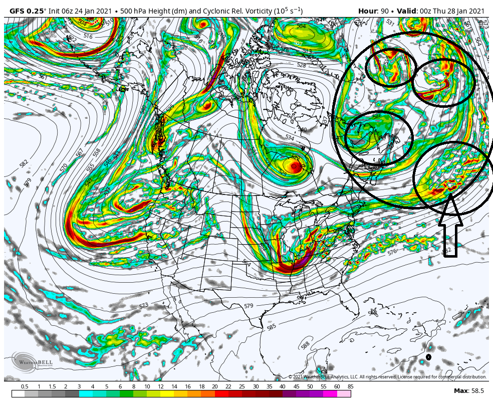
Here is the energy that is the Tuesday system. As you can see it becomes a part of the conglomerate that is what I referred to as a 50/50 low "complex" There is so much conjestion out there in the N Atlantic. Im not 100% sure the exact implications if any. The Tuesday energy has been modeled to be so strung out that the timing of the precip may simply be a product of where the Timing is relative to where the best lift is, which is marginal with how strung out it is. Models may have simply had a hard time sorting that out.
Another way to perhaps look at it; however, would be to say that the delay leads to the poor spacing between the 3&5 I outlined below. Perhaps if it were in and out late Monday into Tuesday that would widen the gap between 3&5.
_________________
"In weather and in life, there's no winning and losing; there's only winning and learning."
WINTER 2012/2013 TOTALS 43.65"WINTER 2017/2018 TOTALS 62.85" WINTER 2022/2023 TOTALS 4.9"
WINTER 2013/2014 TOTALS 64.85"WINTER 2018/2019 TOTALS 14.25" WINTER 2023/2024 TOTALS 13.1"
WINTER 2014/2015 TOTALS 71.20"WINTER 2019/2020 TOTALS 6.35"
WINTER 2015/2016 TOTALS 35.00"WINTER 2020/2021 TOTALS 37.75"
WINTER 2016/2017 TOTALS 42.25"WINTER 2021/2022 TOTALS 31.65"

sroc4- Admin

- Posts : 8354
Reputation : 302
Join date : 2013-01-07
Location : Wading River, LI
 Re: JANUARY 28th Storm Potential
Thanks. Yeah I do think the timing is an in-part function of how strung out the energy becomes. And I think the spacing you reference could be the negative impact, if there is one.

billg315- Advanced Forecaster - Mod

- Posts : 4483
Reputation : 185
Join date : 2015-01-24
Age : 50
Location : Flemington, NJ
 Re: JANUARY 28th Storm Potential
12z GFS still a bit south except for the South Jersey folks. Surface Low slides off near the VA/NC border and blows up a bit too far S and E for most of us. 500 closes off a ways off the coast somewhere east of Delmarva.

billg315- Advanced Forecaster - Mod

- Posts : 4483
Reputation : 185
Join date : 2015-01-24
Age : 50
Location : Flemington, NJ
 Re: JANUARY 28th Storm Potential
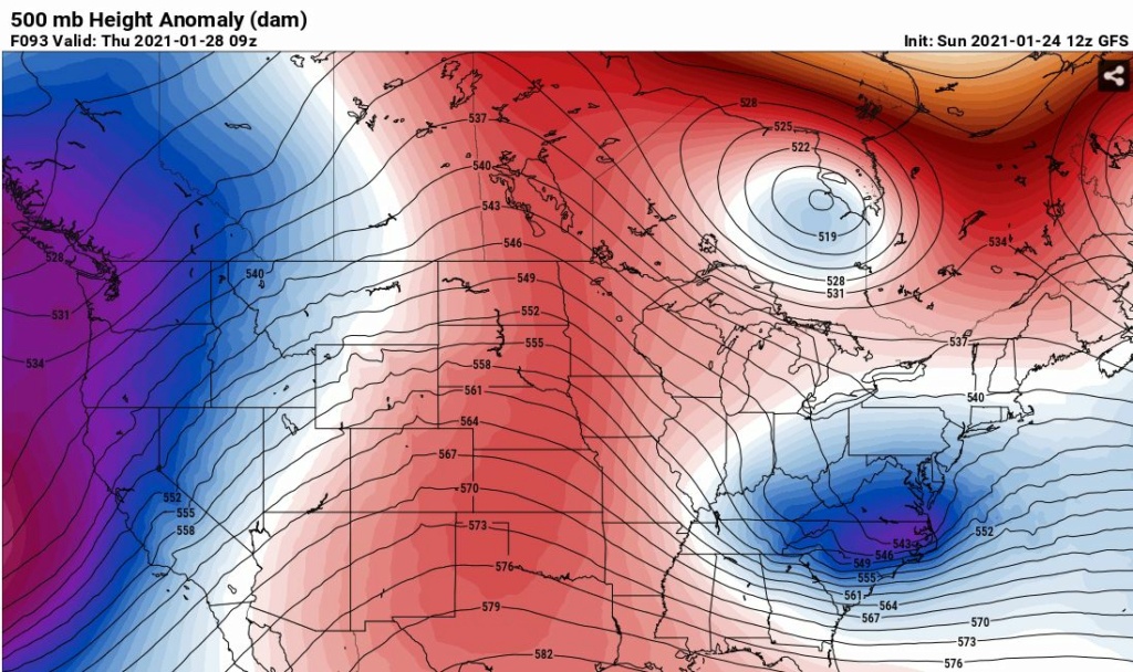
I think the most critical thing for our SE folks is when this storm matures. It's going to mature for sure, but if 500 mb doesn't close off until after hitting the coast then forget about it. Even DC won't be getting much. If it closes off 100/150 miles before hitting the coast then SE Jersey is going to do very well. There's going to be a hard limit on how far north it gets, but it's all about the maturity of the ULL.
This GFS run won't cut it for most folks even those in DC. This would be a moderate hit for Delmarva up to Cape May. If this was already closed off much different output.
This GFS run won't cut it for most folks even those in DC. This would be a moderate hit for Delmarva up to Cape May. If this was already closed off much different output.

heehaw453- Advanced Forecaster

- Posts : 3906
Reputation : 86
Join date : 2014-01-20
Location : Bedminster Township, PA Elevation 600' ASL
 Re: JANUARY 28th Storm Potential
billg315 wrote:12z GFS still a bit south except for the South Jersey folks. Surface Low slides off near the VA/NC border and blows up a bit too far S and E for most of us. 500 closes off a ways off the coast somewhere east of Delmarva.
That's the key for our SE folks. The maturity of the ULL will mean everything.
heehaw453- Advanced Forecaster

- Posts : 3906
Reputation : 86
Join date : 2014-01-20
Location : Bedminster Township, PA Elevation 600' ASL
 Re: JANUARY 28th Storm Potential
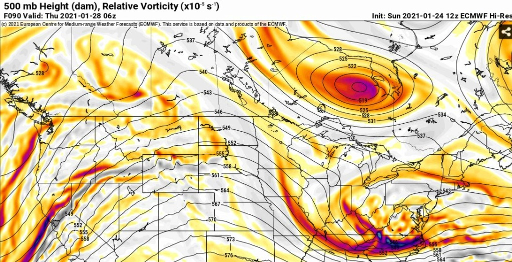
For our SE folks this is not what you want to see for the storm. Just look at the 500 mb and you don't even need to look at the surface panels. It's not sharp and not even close to closing off. I'd give this 36-48 hours more for changes in that ULL before writing it off though. The maturation process of a storm is extremely complex.
Euro 12Z
Euro 12Z

heehaw453- Advanced Forecaster

- Posts : 3906
Reputation : 86
Join date : 2014-01-20
Location : Bedminster Township, PA Elevation 600' ASL
 Re: JANUARY 28th Storm Potential
Maybe it’s the effect of Bill’s theory of the delayed 26th storm creating that log jam to our north. I’d almost be ok if that’s the case since the trend this winter has definitely favored storms starting earlier and leaving sooner. But, the far greater trend is for storms miss exit 80 altogether, so Im going to (try to) go back to shutting up for a bit and see what happens. lol
I do appreciate all the updates though!! Still a lot better than having nothing to track at all, that’s for sure!!
I do appreciate all the updates though!! Still a lot better than having nothing to track at all, that’s for sure!!
SENJsnowman- Senior Enthusiast

- Posts : 1189
Reputation : 61
Join date : 2017-01-06
Age : 51
Location : Bayville, NJ
 Re: JANUARY 28th Storm Potential
18Z nam Is doing something very interesting with this threat. It forms some form of inverted trough like feature and has us snowing At the end of its run Other models are also hinting at this. We will have left over Moisture from the Tuesday Wednesday system So maybe we can squeeze out a few inches From this

algae888- Advanced Forecaster

- Posts : 5311
Reputation : 46
Join date : 2013-02-05
Age : 62
Location : mt. vernon, new york
 Re: JANUARY 28th Storm Potential
TWC has basically removed the threat for Thursday, latest runs must really have this system staying south.

Irish- Pro Enthusiast

- Posts : 788
Reputation : 19
Join date : 2019-01-16
Age : 45
Location : Old Bridge, NJ
 Re: JANUARY 28th Storm Potential
Staying way south. Winter is over... Bring on Hurricane season.
larryrock72- Posts : 140
Reputation : 5
Join date : 2017-01-03
Age : 52
Location : Barnegat, NJ
 Re: JANUARY 28th Storm Potential
larryrock72 wrote:Staying way south. Winter is over... Bring on Hurricane season.
LMAO! Winter sucks anymore.

Irish- Pro Enthusiast

- Posts : 788
Reputation : 19
Join date : 2019-01-16
Age : 45
Location : Old Bridge, NJ
 Re: JANUARY 28th Storm Potential
NWS has also removed any mention of snow for Thursday in Nassau county, Li., so it appears that along with the Packers and Bills, this "event" will be just
Looking down the road, next Sunday, Monday and Tuesday are all showing prep., but temps look marginal. Following that pattern where hey there may be something the models are picking up on coming up only to have it fizzle out as it gets closer in range seems to be the M.O this winter.
Winter just past the halfway mark, so not throwing in the towel just yet, but the door to the linen closet just cracked open a bit.
GreyBeard- Senior Enthusiast

- Posts : 725
Reputation : 34
Join date : 2014-02-12
Location : eastern nassau county
CPcantmeasuresnow likes this post
 Re: JANUARY 28th Storm Potential
This storm may not even bring measurable snow down in Washington DC when all is said and done, which is actually a good thing.
They are ten days away from their longest streak without measurable snow. It's already over a year long. Since they're that close, why not just go for it.
They are ten days away from their longest streak without measurable snow. It's already over a year long. Since they're that close, why not just go for it.

CPcantmeasuresnow- Wx Statistician Guru

- Posts : 7274
Reputation : 230
Join date : 2013-01-07
Age : 103
Location : Eastern Orange County, NY
 Re: JANUARY 28th Storm Potential
I'm with you on that CP, but I thought this favored a more southern route. Would be a shame to lose the record over some minor accumulation.
GreyBeard- Senior Enthusiast

- Posts : 725
Reputation : 34
Join date : 2014-02-12
Location : eastern nassau county
 Re: JANUARY 28th Storm Potential
This one is most likely done. The storm matures way too late and that was the only real shot. Maybe NE/LI gets some trough hookup for modest snow, but it won't be from the main storm.
heehaw453- Advanced Forecaster

- Posts : 3906
Reputation : 86
Join date : 2014-01-20
Location : Bedminster Township, PA Elevation 600' ASL
 Re: JANUARY 28th Storm Potential
CPcantmeasuresnow wrote:This storm may not even bring measurable snow down in Washington DC when all is said and done, which is actually a good thing.
They are ten days away from their longest streak without measurable snow. It's already over a year long. Since they're that close, why not just go for it.
That is an absolutely incredible feat. I agree with you it's once in a life time and why stop short on something like that. Not sure I could take that though and I'd probably have to move to Watertown NY after going through something like that.
heehaw453- Advanced Forecaster

- Posts : 3906
Reputation : 86
Join date : 2014-01-20
Location : Bedminster Township, PA Elevation 600' ASL
 Re: JANUARY 28th Storm Potential
Horrific performance by the GFS. Euro was consistent in showing a storm pass way to our south. Regardless of the models, this one didn’t have much of a shot as Scott showed in his write up. Frustrating to lose back to back snowfall threats in a short window. Let’s hope February gives us something to track
_________________
_______________________________________________________________________________________________________
CLICK HERE to view NJ Strong Snowstorm Classifications
 Re: JANUARY 28th Storm Potential
Damn, that rb guy was right again!

Irish- Pro Enthusiast

- Posts : 788
Reputation : 19
Join date : 2019-01-16
Age : 45
Location : Old Bridge, NJ
phil155 likes this post
 Re: JANUARY 28th Storm Potential
Irish wrote:Damn, that rb guy was right again!
"Khaaaaaaaaaaaaan!!!!!"

essexcountypete- Pro Enthusiast

- Posts : 783
Reputation : 12
Join date : 2013-12-09
Location : Bloomfield, NJ
Grselig likes this post
 Re: JANUARY 28th Storm Potential
Irish wrote:Damn, that rb guy was right again!
RB really knows his stuff and based upon that I am not very hopeful for the rest of the winter
phil155- Pro Enthusiast

- Posts : 483
Reputation : 4
Join date : 2019-12-16
Irish likes this post
Permissions in this forum:
You cannot reply to topics in this forum|
|
|

 Home
Home