
 Search
Long Range Discussion 22.0
Page 14 of 31 •  1 ... 8 ... 13, 14, 15 ... 22 ... 31
 ![]()
Re: Long Range Discussion 22.0
![]() by sroc4 Mon Dec 20, 2021 5:30 pm
by sroc4 Mon Dec 20, 2021 5:30 pm
CPcantmeasuresnow wrote:Frank_Wx wrote:amugs wrote:if true then whoa!!
If true the pattern will do a complete 180
Let’s hope!!
Frank or Mugs please explain. I have barely a clue what this represents. I know it’s something I’d like just from Mugsys reaction and Frank’s comment but would love to know the reason. Also what time period are we talking about this possible 180?
Thanks I advance.
Not a whole lot to add to Matty Ice's comments.
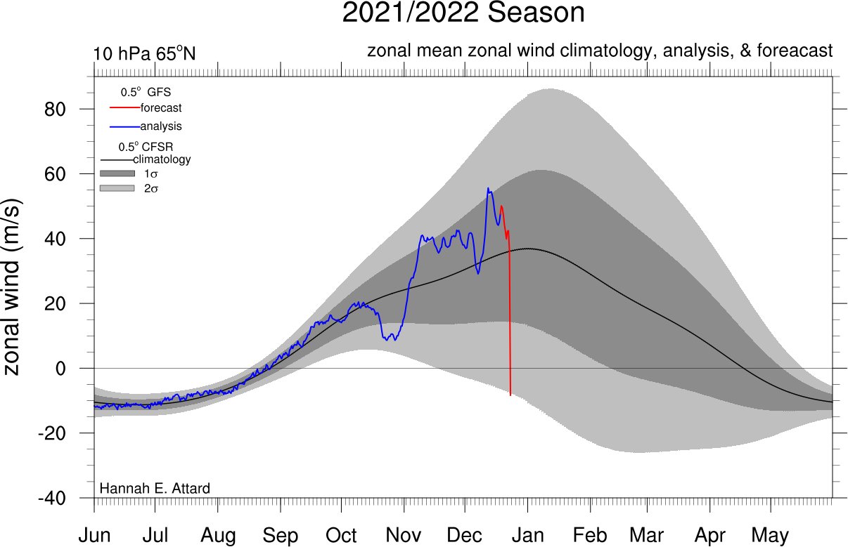
Click the link. This is the current winds at the 10 mb level. Save this link to favorites and come back to it in a few weeks to see how it has evolved.
For those who have never seen this site its pretty cool. Bottom left click on "EARTH" to play with the different levels of the atmosphere from 10 mb(hpa) of the stratosphere down to the surface. Also left click and hold anywhere over the image and move the mouse to manipulate the position of the earth view and use your mouses wheel to zoom in and out.
https://earth.nullschool.net/#current/wind/isobaric/10hPa/orthographic=-80.99,72.04,414
sroc4- Admin

- Posts : 8331
Join date : 2013-01-07
CPcantmeasuresnow and rb924119 like this post
Re: Long Range Discussion 22.0
![]() by amugs Mon Dec 20, 2021 5:54 pm
by amugs Mon Dec 20, 2021 5:54 pm
MattICE ICE baby this would change the complexity of the pattern and cause higher pressures over the Arctic dislodged arctic air southward. This shows a perturbed polar vortex. The affects would be very positive overall.
Good explanation Matty.
Now for the MJO wave. See the greenish colors those are our waves, lower pressures. The map underneath shows the phases of the MJO. Remember phase 8-1-2 are the heart of winter phases we do very well with wintry weather.
We are in phase seven going into 8.
Then you see at Jan 6th time through the end of the run the wave develops in the Indian Ocean and is a strong 1 then 2 as we end Jan. This aligns with Rb thoughts on 2nd week to 3rd week things take off. Patience for sure but looking very good.

amugs- Advanced Forecaster - Mod

- Posts : 15093
Join date : 2013-01-07
CPcantmeasuresnow, rb924119 and MattyICE like this post
Re: Long Range Discussion 22.0
![]() by Frank_Wx Mon Dec 20, 2021 8:09 pm
by Frank_Wx Mon Dec 20, 2021 8:09 pm
MattyICE wrote:CPcantmeasuresnow wrote:Frank_Wx wrote:amugs wrote:if true then whoa!!
If true the pattern will do a complete 180
Let’s hope!!
Frank or Mugs please explain. I have barely a clue what this represents. I know it’s something I’d like just from Mugsys reaction and Frank’s comment but would love to know the reason. Also what time period are we talking about this possible 180?
Thanks I advance.
I’m not them, lol, but this is my stab - VERBATIM this indicates a reversal of the zonal winds way up at the top of the stratosphere. This would end our period of a very strong (positive) polar vortex and suggest at least a significant weakening - maybe even a sudden stratospheric warming event or something in between (regardless it would portend a negative Arctic Oscillation and help displace colder air further south). If the strat and trop are coupled there is still frequently a lag of usually 2 weeks before results propagate down to our sensible weather. Could be right inline with a lot of what Ray has been highlighting as his process and timeline, if correct.
Spot on
_________________
_______________________________________________________________________________________________________
CLICK HERE to view NJ Strong Snowstorm Classifications

Frank_Wx- Godzilla Seeker
- Posts : 21305
Reputation : 328
Join date : 2013-01-05
Age : 31
Location : Jersey City, NJ -

MattyICE likes this post
Re: Long Range Discussion 22.0
![]() by Snow88 Tue Dec 21, 2021 12:04 am
by Snow88 Tue Dec 21, 2021 12:04 am
Yes the storms get shredded but there is plenty of cold air around. NAO doing work.

Snow88- Senior Enthusiast

- Posts : 2193
Reputation : 4
Join date : 2013-01-09
Age : 35
Location : Brooklyn, NY
Re: Long Range Discussion 22.0
![]() by rb924119 Tue Dec 21, 2021 12:51 am
by rb924119 Tue Dec 21, 2021 12:51 am
sroc4 wrote:I’ve been quiet. I am just not sure. I am just not that excited about any of it right now. Until the PNA region changes I just don’t know. The PNA is currently sitting between -3 & -4 standard deviations and forecast is to get down to -5 over the next 3-5 days, and remain somewhere between -4 & -5 for 7-10days beyond that before slowly coming back up as we head into the first week of Jan. But even then it’s still -1 to -2. With a PNA that negative it give the atmosphere a back door to slip out of. It allows the cold to pool in the west despite the -NAO/-AO/-EPO, Make no mistake it will get colder than it has been for sure, and there may be some snow chances, but the sustained cold and more importantly and likely is the storm track is likely to remain meh at best. At least for awhile.
I think very cautious optimism is needed right now.
Quiet? More like MIA lmao I’ve been waiting for some form of rebuttal, or discussion, or SOMETHING, and we’ve gotten less than crickets haha I was getting ready to send the search party for you and CP! Haha
Regarding the rest of your post, though, patience will be key over the next few weeks yet, IMO. I fully agree that there isn’t anything to get excited about before then, but I am still very much liking Week 2/the middle ten days of January as our transition, and I still firmly think there is A LOT to be excited about. But, we have to survive until then.
rb924119- Meteorologist

- Posts : 6890
Reputation : 194
Join date : 2013-02-06
Age : 32
Location : Greentown, Pa
sroc4 likes this post
Re: Long Range Discussion 22.0
![]() by rb924119 Tue Dec 21, 2021 12:53 am
by rb924119 Tue Dec 21, 2021 12:53 am
Frank_Wx wrote:amugs wrote:if true then whoa!!
If true the pattern will do a complete 180
Let’s hope!!
rb924119- Meteorologist
- Posts : 6890
Reputation : 194
Join date : 2013-02-06
Age : 32
Location : Greentown, Pa
Re: Long Range Discussion 22.0
![]() by rb924119 Tue Dec 21, 2021 12:54 am
by rb924119 Tue Dec 21, 2021 12:54 am
MattyICE wrote:CPcantmeasuresnow wrote:Frank_Wx wrote:amugs wrote:if true then whoa!!
If true the pattern will do a complete 180
Let’s hope!!
Frank or Mugs please explain. I have barely a clue what this represents. I know it’s something I’d like just from Mugsys reaction and Frank’s comment but would love to know the reason. Also what time period are we talking about this possible 180?
Thanks I advance.
I’m not them, lol, but this is my stab - VERBATIM this indicates a reversal of the zonal winds way up at the top of the stratosphere. This would end our period of a very strong (positive) polar vortex and suggest at least a significant weakening - maybe even a sudden stratospheric warming event or something in between (regardless it would portend a negative Arctic Oscillation and help displace colder air further south). If the strat and trop are coupled there is still frequently a lag of usually 2 weeks before results propagate down to our sensible weather. Could be right inline with a lot of what Ray has been highlighting as his process and timeline, if correct.
NAILED IT.
rb924119- Meteorologist
- Posts : 6890
Reputation : 194
Join date : 2013-02-06
Age : 32
Location : Greentown, Pa
MattyICE likes this post
Re: Long Range Discussion 22.0
![]() by rb924119 Tue Dec 21, 2021 1:01 am
by rb924119 Tue Dec 21, 2021 1:01 am
amugs wrote:CP has awoken from his slumber!!
MattICE ICE baby this would change the complexity of the pattern and cause higher pressures over the Arctic dislodged arctic air southward. This shows a perturbed polar vortex. The affects would be very positive overall.
Good explanation Matty.
Now for the MJO wave. See the greenish colors those are our waves, lower pressures. The map underneath shows the phases of the MJO. Remember phase 8-1-2 are the heart of winter phases we do very well with wintry weather.
We are in phase seven going into 8.
Then you see at Jan 6th time through the end of the run the wave develops in the Indian Ocean and is a strong 1 then 2 as we end Jan. This aligns with Rb thoughts on 2nd week to 3rd week things take off. Patience for sure but looking very good.
We’re almost to the boat, mugs!! We can do this!! I just hope the line doesn’t snap when we finally get it to the boat!! Lmao loose drag, and take what it gives us; it’s a war of attrition, a battle of the wills!! Who relents first, us, or our whale of a forecast??? As far as I’m concerned……..
“That taxidermist is gonna have a heart attack when he sees what we brung “im!!” Haha
rb924119- Meteorologist
- Posts : 6890
Reputation : 194
Join date : 2013-02-06
Age : 32
Location : Greentown, Pa
amugs and phil155 like this post
Re: Long Range Discussion 22.0
![]() by Snow88 Tue Dec 21, 2021 8:14 am
by Snow88 Tue Dec 21, 2021 8:14 am
That's why it's warm now but it's not bad in January. Phase 8 and 1 are the better phases in January.
Snow88- Senior Enthusiast
- Posts : 2193
Reputation : 4
Join date : 2013-01-09
Age : 35
Location : Brooklyn, NY
rb924119 likes this post
Re: Long Range Discussion 22.0
![]() by sroc4 Tue Dec 21, 2021 9:49 am
by sroc4 Tue Dec 21, 2021 9:49 am
https://www.longpaddock.qld.gov.au/soi/
_________________
"In weather and in life, there's no winning and losing; there's only winning and learning."
WINTER 2012/2013 TOTALS 43.65"WINTER 2017/2018 TOTALS 62.85" WINTER 2022/2023 TOTALS 4.9"
WINTER 2013/2014 TOTALS 64.85"WINTER 2018/2019 TOTALS 14.25" WINTER 2023/2024 TOTALS 13.1"
WINTER 2014/2015 TOTALS 71.20"WINTER 2019/2020 TOTALS 6.35"
WINTER 2015/2016 TOTALS 35.00"WINTER 2020/2021 TOTALS 37.75"
WINTER 2016/2017 TOTALS 42.25"WINTER 2021/2022 TOTALS 31.65"

sroc4- Admin
- Posts : 8331
Reputation : 301
Join date : 2013-01-07
Location : Wading River, LI
amugs and rb924119 like this post
Re: Long Range Discussion 22.0
![]() by heehaw453 Tue Dec 21, 2021 11:50 am
by heehaw453 Tue Dec 21, 2021 11:50 am

heehaw453- Advanced Forecaster

- Posts : 3906
Reputation : 86
Join date : 2014-01-20
Location : Bedminster Township, PA Elevation 600' ASL
rb924119 likes this post
Re: Long Range Discussion 22.0
![]() by Snow88 Tue Dec 21, 2021 1:35 pm
by Snow88 Tue Dec 21, 2021 1:35 pm
Mid Atlantic, SNE , PA and even the lake regions are struggling in this pattern .
Snow88- Senior Enthusiast
- Posts : 2193
Reputation : 4
Join date : 2013-01-09
Age : 35
Location : Brooklyn, NY
phil155 likes this post
Re: Long Range Discussion 22.0
![]() by sroc4 Tue Dec 21, 2021 2:19 pm
by sroc4 Tue Dec 21, 2021 2:19 pm
Snow88 wrote:We can't even get a strong storm in this pattern .
Mid Atlantic, SNE , PA and even the lake regions are struggling in this pattern .
This tells it all Tony

_________________
"In weather and in life, there's no winning and losing; there's only winning and learning."
WINTER 2012/2013 TOTALS 43.65"WINTER 2017/2018 TOTALS 62.85" WINTER 2022/2023 TOTALS 4.9"
WINTER 2013/2014 TOTALS 64.85"WINTER 2018/2019 TOTALS 14.25" WINTER 2023/2024 TOTALS 13.1"
WINTER 2014/2015 TOTALS 71.20"WINTER 2019/2020 TOTALS 6.35"
WINTER 2015/2016 TOTALS 35.00"WINTER 2020/2021 TOTALS 37.75"
WINTER 2016/2017 TOTALS 42.25"WINTER 2021/2022 TOTALS 31.65"
sroc4- Admin
- Posts : 8331
Reputation : 301
Join date : 2013-01-07
Location : Wading River, LI
Snow88 and SENJsnowman like this post
Re: Long Range Discussion 22.0
![]() by SENJsnowman Tue Dec 21, 2021 3:08 pm
by SENJsnowman Tue Dec 21, 2021 3:08 pm
There had been some hope for this present pattern to produce at least a little something by late Dec, but that’s now doneski. And at the same the indicators continue to give real hope for that 180 that Frank mentioned yesterday.
And there’s rb who said yes to both of these two weeks ago and that the worse this pattern gets, the better the flip actually could be for us. And so far, his sketch has played out.
So, I just want to know if that’s an accurate synthesis of what’s been discussed here the last few days.
SENJsnowman- Senior Enthusiast
- Posts : 1186
Reputation : 61
Join date : 2017-01-06
Age : 51
Location : Bayville, NJ
rb924119 likes this post
Re: Long Range Discussion 22.0
![]() by heehaw453 Tue Dec 21, 2021 3:42 pm
by heehaw453 Tue Dec 21, 2021 3:42 pm
SENJsnowman wrote:Correct me if I’m wrong. There’s two concurrent conversations taking place in this thread. One is about the 7-10 long range forecast which looks to be as crappy as the last 7-10 days were due to a continued -pna, + nao, mjo7 and a stout se ridge. The other is about the extended long range forecast which continues to show a potential mid Jan flip to mjo 8, + pna, -nao and/or sswe/pv disruption into Canada.
There had been some hope for this present pattern to produce at least a little something by late Dec, but that’s now doneski. And at the same the indicators continue to give real hope for that 180 that Frank mentioned yesterday.
And there’s rb who said yes to both of these two weeks ago and that the worse this pattern gets, the better the flip actually could be for us. And so far, his sketch has played out.
So, I just want to know if that’s an accurate synthesis of what’s been discussed here the last few days.
My take the PNA is a big problem as it's forcing a stout SE ridge just to our west which stops colder air from advancing east and kills any hope of storm amplification. Even that being said I'd dare to say those NW of 95 will probably see some snow accumulations before NYD due to AO. Some meaning very modest on the order of a few inches. The issue is when you move the PNA trough and consequently SE ridge what do you give up? Does the NAO/AO give in or does the Aleutian ridge give in a bit? I work backwards from the AO personally and if we lose that then I think it'd tough to overcome on the coastal plain. Not that this -PNA is much better., but push comes to shove I'll take the -AO. The MJO and it's effects are tough to call. The waves are fickle and if you ask 3 different experts you'll get 3 different answers. The PV perturbation is just as tough call to know it's effects on our sensible weather. La Nina bad starts generally don't end well historically. RB has been very accurate so far this year and I applaud him trying to make sense of such enormous complexity.
heehaw453- Advanced Forecaster
- Posts : 3906
Reputation : 86
Join date : 2014-01-20
Location : Bedminster Township, PA Elevation 600' ASL
rb924119 and SENJsnowman like this post
Re: Long Range Discussion 22.0
![]() by SENJsnowman Tue Dec 21, 2021 4:18 pm
by SENJsnowman Tue Dec 21, 2021 4:18 pm
heehaw453 wrote:SENJsnowman wrote:Correct me if I’m wrong. There’s two concurrent conversations taking place in this thread. One is about the 7-10 long range forecast which looks to be as crappy as the last 7-10 days were due to a continued -pna, + nao, mjo7 and a stout se ridge. The other is about the extended long range forecast which continues to show a potential mid Jan flip to mjo 8, + pna, -nao and/or sswe/pv disruption into Canada.
There had been some hope for this present pattern to produce at least a little something by late Dec, but that’s now doneski. And at the same the indicators continue to give real hope for that 180 that Frank mentioned yesterday.
And there’s rb who said yes to both of these two weeks ago and that the worse this pattern gets, the better the flip actually could be for us. And so far, his sketch has played out.
So, I just want to know if that’s an accurate synthesis of what’s been discussed here the last few days.
My take the PNA is a big problem as it's forcing a stout SE ridge just to our west which stops colder air from advancing east and kills any hope of storm amplification. Even that being said I'd dare to say those NW of 95 will probably see some snow accumulations before NYD due to AO. Some meaning very modest on the order of a few inches. The issue is when you move the PNA trough and consequently SE ridge what do you give up? Does the NAO/AO give in or does the Aleutian ridge give in a bit? I work backwards from the AO personally and if we lose that then I think it'd tough to overcome on the coastal plain. Not that this -PNA is much better., but push comes to shove I'll take the -AO. The MJO and it's effects are tough to call. The waves are fickle and if you ask 3 different experts you'll get 3 different answers. The PV perturbation is just as tough call to know it's effects on our sensible weather. La Nina bad starts generally don't end well historically. RB has been very accurate so far this year and I applaud him trying to make sense of such enormous complexity.
Ok, so if I follow your big picture thinking here, where I have bolded is where you transition away from here to nye and more into early Jan and your concerns for how those pattern changing dominoes might actually fall in a way that would make the dead of winter just awful to endure for a coastal snow weenie like me. Not your prediction, but what could go wrong even if things at first seem to go right.
So, you want to see if the pna changes at all first and then also what the effects of that change is? Because the change doesn’t necessarily have to create a good effect in the end for us.
Essentially we have another baby bear. Not only do these changes have to actually take place, but they also have to the hoped for results down stream. Got it. Patience, trust the process AND hope for the best. Thank you heehaw!!
In the meantime me and that stout pna getting ready for some twilight bbq.
SENJsnowman- Senior Enthusiast
- Posts : 1186
Reputation : 61
Join date : 2017-01-06
Age : 51
Location : Bayville, NJ
rb924119 and heehaw453 like this post
Re: Long Range Discussion 22.0
![]() by Frank_Wx Wed Dec 22, 2021 12:31 pm
by Frank_Wx Wed Dec 22, 2021 12:31 pm
SENJsnowman wrote:Correct me if I’m wrong. There’s two concurrent conversations taking place in this thread. One is about the 7-10 long range forecast which looks to be as crappy as the last 7-10 days were due to a continued -pna, + nao, mjo7 and a stout se ridge. The other is about the extended long range forecast which continues to show a potential mid Jan flip to mjo 8, + pna, -nao and/or sswe/pv disruption into Canada.
There had been some hope for this present pattern to produce at least a little something by late Dec, but that’s now doneski. And at the same the indicators continue to give real hope for that 180 that Frank mentioned yesterday.
And there’s rb who said yes to both of these two weeks ago and that the worse this pattern gets, the better the flip actually could be for us. And so far, his sketch has played out.
So, I just want to know if that’s an accurate synthesis of what’s been discussed here the last few days.
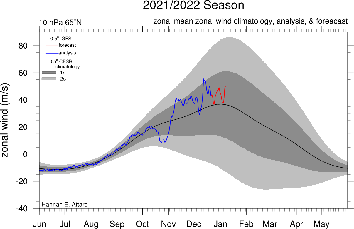
Heehaw summarized it fantastically. Below is a snapshot of the EURO Ensemble mean after Christmas. It continues to advertise this -PNA/-WPO pattern that has been keeping the cold air well off to our west. The -NAO is nice, but it's not strong enough nor oriented in a way that tries to subdue the SE ridge. Instead, we're seeing both ridges lock-in over the eastern CONUS/Canada. The EURO is a bit more aggressive with this ridging than the GEFS, but honestly I think it has the right idea even if it's overdone a bit. We're looking at a pretty crummy pattern all the way into the first few days of January.

That map Mugs posted of the zonal winds in the Stratosphere, which showed a SSWE, now looks like this. It's a drastic change run to run. Whether you're looking up in the Stratosphere or at the MJO plots, these things are changing drastically day to day. That said, you can't underestimate their magnitude and what it means for our sensible weather. Until we truly know what's going on with the tropical pacific waves, it really is anyones guess when the pattern flips. I will say, RB has been on top of it and his timeline is more mid/end of January. It may very well take that long.
_________________
_______________________________________________________________________________________________________
CLICK HERE to view NJ Strong Snowstorm Classifications
Frank_Wx- Godzilla Seeker
- Posts : 21305
Reputation : 328
Join date : 2013-01-05
Age : 31
Location : Jersey City, NJ -
rb924119 and heehaw453 like this post
Re: Long Range Discussion 22.0
![]() by Snow88 Wed Dec 22, 2021 7:20 pm
by Snow88 Wed Dec 22, 2021 7:20 pm
Snow88- Senior Enthusiast
- Posts : 2193
Reputation : 4
Join date : 2013-01-09
Age : 35
Location : Brooklyn, NY
Re: Long Range Discussion 22.0
![]() by amugs Wed Dec 22, 2021 8:28 pm
by amugs Wed Dec 22, 2021 8:28 pm
_________________
Mugs
AKA:King: Snow Weenie
Self Proclaimed
WINTER 2014-15 : 55.12" +.02 for 6 coatings (avg. 35")
WINTER 2015-16 Total - 29.8" (Avg 35")
WINTER 2016-17 : 39.5" so far

amugs- Advanced Forecaster - Mod
- Posts : 15093
Reputation : 213
Join date : 2013-01-07
Age : 54
Location : Hillsdale,NJ
rb924119 likes this post
Re: Long Range Discussion 22.0
![]() by heehaw453 Thu Dec 23, 2021 9:30 am
by heehaw453 Thu Dec 23, 2021 9:30 am
heehaw453- Advanced Forecaster
- Posts : 3906
Reputation : 86
Join date : 2014-01-20
Location : Bedminster Township, PA Elevation 600' ASL
rb924119 and phil155 like this post
Re: Long Range Discussion 22.0
![]() by SENJsnowman Thu Dec 23, 2021 11:17 pm
by SENJsnowman Thu Dec 23, 2021 11:17 pm
Frank_Wx wrote:SENJsnowman wrote:Correct me if I’m wrong. There’s two concurrent conversations taking place in this thread. One is about the 7-10 long range forecast which looks to be as crappy as the last 7-10 days were due to a continued -pna, + nao, mjo7 and a stout se ridge. The other is about the extended long range forecast which continues to show a potential mid Jan flip to mjo 8, + pna, -nao and/or sswe/pv disruption into Canada.
There had been some hope for this present pattern to produce at least a little something by late Dec, but that’s now doneski. And at the same the indicators continue to give real hope for that 180 that Frank mentioned yesterday.
And there’s rb who said yes to both of these two weeks ago and that the worse this pattern gets, the better the flip actually could be for us. And so far, his sketch has played out.
So, I just want to know if that’s an accurate synthesis of what’s been discussed here the last few days.
Heehaw summarized it fantastically. Below is a snapshot of the EURO Ensemble mean after Christmas. It continues to advertise this -PNA/-WPO pattern that has been keeping the cold air well off to our west. The -NAO is nice, but it's not strong enough nor oriented in a way that tries to subdue the SE ridge. Instead, we're seeing both ridges lock-in over the eastern CONUS/Canada. The EURO is a bit more aggressive with this ridging than the GEFS, but honestly I think it has the right idea even if it's overdone a bit. We're looking at a pretty crummy pattern all the way into the first few days of January.
That map Mugs posted of the zonal winds in the Stratosphere, which showed a SSWE, now looks like this. It's a drastic change run to run. Whether you're looking up in the Stratosphere or at the MJO plots, these things are changing drastically day to day. That said, you can't underestimate their magnitude and what it means for our sensible weather. Until we truly know what's going on with the tropical pacific waves, it really is anyones guess when the pattern flips. I will say, RB has been on top of it and his timeline is more mid/end of January. It may very well take that long.
Thanks very much for your response Frank- those follow up maps/charts really make your points easy to follow. HeeHaw Mugs and Sroc etc also thanks for all the info and feedback.
SENJsnowman- Senior Enthusiast
- Posts : 1186
Reputation : 61
Join date : 2017-01-06
Age : 51
Location : Bayville, NJ
sroc4 and amugs like this post
Re: Long Range Discussion 22.0
![]() by amugs Thu Dec 23, 2021 11:37 pm
by amugs Thu Dec 23, 2021 11:37 pm
Usually means a colder and stories look east of the Rockies. This is good news again despite some other news on the PV and West Coast deep Negative trough that is messing up our N NAO!!


_________________
Mugs
AKA:King: Snow Weenie
Self Proclaimed
WINTER 2014-15 : 55.12" +.02 for 6 coatings (avg. 35")
WINTER 2015-16 Total - 29.8" (Avg 35")
WINTER 2016-17 : 39.5" so far
amugs- Advanced Forecaster - Mod
- Posts : 15093
Reputation : 213
Join date : 2013-01-07
Age : 54
Location : Hillsdale,NJ
rb924119 likes this post
Re: Long Range Discussion 22.0
![]() by Wheezer Fri Dec 24, 2021 6:24 am
by Wheezer Fri Dec 24, 2021 6:24 am
amugs wrote:Tjis zonal winds over the Indian Ocean show what would be a moderate to strong Rosby Wave burst in phase 1 and then 2 for almost all of January into early Feb. Let's see what affects this will have on our pattern upstream from this.
Usually means a colder and stories look east of the Rockies. This is good news again despite some other news on the PV and West Coast deep Negative trough that is messing up our N NAO!!
Wouldn't the forecast for the MJO be responding to this, it sure doesn't look like it. Even if this comes about , I think it takes more than a moderate wave to overcome the persistent easterlies at the dateline, to give the MJO momentum for reaching the promised land
Wheezer- Posts : 30
Reputation : 6
Join date : 2017-11-08
Location : Cincinnati, Oh
Re: Long Range Discussion 22.0
![]() by Frank_Wx Fri Dec 24, 2021 8:22 am
by Frank_Wx Fri Dec 24, 2021 8:22 am
Wheezer wrote:amugs wrote:Tjis zonal winds over the Indian Ocean show what would be a moderate to strong Rosby Wave burst in phase 1 and then 2 for almost all of January into early Feb. Let's see what affects this will have on our pattern upstream from this.
Usually means a colder and stories look east of the Rockies. This is good news again despite some other news on the PV and West Coast deep Negative trough that is messing up our N NAO!!
Wouldn't the forecast for the MJO be responding to this, it sure doesn't look like it. Even if this comes about , I think it takes more than a moderate wave to overcome the persistent easterlies at the dateline, to give the MJO momentum for reaching the promised land
Agree with this…it’s possible the MJO is having a hard time picking up on this wave. Naturally, I would expect a progression eastward. The issue is La Niña easterlies are very strong and are threatening this progression. Probably the number one risk to our overall pattern right now.
_________________
_______________________________________________________________________________________________________
CLICK HERE to view NJ Strong Snowstorm Classifications
Frank_Wx- Godzilla Seeker
- Posts : 21305
Reputation : 328
Join date : 2013-01-05
Age : 31
Location : Jersey City, NJ -
Re: Long Range Discussion 22.0
![]() by Wheezer Fri Dec 24, 2021 8:34 am
by Wheezer Fri Dec 24, 2021 8:34 am
Wheezer- Posts : 30
Reputation : 6
Join date : 2017-11-08
Location : Cincinnati, Oh
Re: Long Range Discussion 22.0
![]() by phil155 Fri Dec 24, 2021 8:57 am
by phil155 Fri Dec 24, 2021 8:57 am
phil155- Pro Enthusiast

- Posts : 475
Reputation : 4
Join date : 2019-12-16
rb924119 likes this post
Re: Long Range Discussion 22.0
![]() by lglickman1 Fri Dec 24, 2021 10:47 am
by lglickman1 Fri Dec 24, 2021 10:47 am
lglickman1- Pro Enthusiast
- Posts : 319
Reputation : 0
Join date : 2013-02-05
Location : New Rochelle, NY
rb924119 likes this post
Page 14 of 31 • 1 ... 8 ... 13, 14, 15 ... 22 ... 31 ![]()
|
|
|