
 Search
Momentum building for possible storm on JAN 16th?
Page 7 of 23 •  1 ... 6, 7, 8 ... 15 ... 23
 ![]()
Re: Momentum building for possible storm on JAN 16th?
![]() by sroc4 Wed Jan 12, 2022 12:56 pm
by sroc4 Wed Jan 12, 2022 12:56 pm
jmanley32 wrote:That storm was insane, forget what I got I know it was somewhat of a let down I was in that second shade of purple, my parents got the death band with 40 inches in CT!! I think that was a record for the area. They said they had never seen it snow so long and so hard. Snow drifted up fiurst gloor windows. It is okay to be selfish, if I can get 6-12 out of this I would be happy, I also won't be entirely surprised if it doesn't work out but heres hoping!sroc4 wrote:Frank_Wx wrote:I think the southern slider scenario can be eliminated. We’re down to three…apps runner, coastal hugger or coastal
For me, and I am going to be a little selfish just for a moment here if I may, I would like the perfect scenario to be a massive front end thump for all, and just as the warm air begins to get close it Miller B's to just at or SE of the BM setting up the CCB right over my house, just like Nemo in Feb 2013. I ended with just under 30".
https://weather.com/storms/winter/nemo/news/winter-storm-nemo-reports-20130208
Edit: I actually did pretty well, I think I got like 12-15, and I remember the winds were insane so I got both my weather obsessions : ) I would be fine with a Nemo again even if you bank. I consider 6+ a bank for these parts.

Here’s to Hoping Jon

sroc4- Admin

- Posts : 8331
Join date : 2013-01-07
rb924119, essexcountypete, heehaw453 and Bwtr like this post
Re: Momentum building for possible storm on JAN 16th?
![]() by jmanley32 Wed Jan 12, 2022 12:58 pm
by jmanley32 Wed Jan 12, 2022 12:58 pm
In between would be better than a NYC runner, that would suck. I dunno I have a tingling that as we close in on the 3 day we are go see some SR craziness. The fact that a OTS is off table is great, the fact that a apps runner is not is not great. But lets hope we can get that off the table too, as scott said baby steps.nutleyblizzard wrote:Still not buying the apps runner since in recent years it’s been a rare and anomalous track. My goalposts have shrunk with this storm. I’m thinking anywhere from an inside the BM to a NYC track.Frank_Wx wrote:I think the southern slider scenario can be eliminated. We’re down to three…apps runner, coastal hugger or coastal
Love this movie, loved it before I became a therapist.
https://www.youtube.com/watch?v=Yl6s6DGapug
jmanley32- Senior Enthusiast

- Posts : 20517
Join date : 2013-12-12
Re: Momentum building for possible storm on JAN 16th?
![]() by jmanley32 Wed Jan 12, 2022 12:58 pm
by jmanley32 Wed Jan 12, 2022 12:58 pm
I remember that pic!! So cute.sroc4 wrote:jmanley32 wrote:That storm was insane, forget what I got I know it was somewhat of a let down I was in that second shade of purple, my parents got the death band with 40 inches in CT!! I think that was a record for the area. They said they had never seen it snow so long and so hard. Snow drifted up fiurst gloor windows. It is okay to be selfish, if I can get 6-12 out of this I would be happy, I also won't be entirely surprised if it doesn't work out but heres hoping!sroc4 wrote:Frank_Wx wrote:I think the southern slider scenario can be eliminated. We’re down to three…apps runner, coastal hugger or coastal
For me, and I am going to be a little selfish just for a moment here if I may, I would like the perfect scenario to be a massive front end thump for all, and just as the warm air begins to get close it Miller B's to just at or SE of the BM setting up the CCB right over my house, just like Nemo in Feb 2013. I ended with just under 30".
https://weather.com/storms/winter/nemo/news/winter-storm-nemo-reports-20130208
Edit: I actually did pretty well, I think I got like 12-15, and I remember the winds were insane so I got both my weather obsessions : ) I would be fine with a Nemo again even if you bank. I consider 6+ a bank for these parts.
Here’s to Hoping Jon

jmanley32- Senior Enthusiast
- Posts : 20517
Reputation : 108
Join date : 2013-12-12
Age : 42
Location : Yonkers, NY
weatherwatchermom likes this post
Re: Momentum building for possible storm on JAN 16th?
![]() by aiannone Wed Jan 12, 2022 1:00 pm
by aiannone Wed Jan 12, 2022 1:00 pm
sroc4 wrote:jmanley32 wrote:That storm was insane, forget what I got I know it was somewhat of a let down I was in that second shade of purple, my parents got the death band with 40 inches in CT!! I think that was a record for the area. They said they had never seen it snow so long and so hard. Snow drifted up fiurst gloor windows. It is okay to be selfish, if I can get 6-12 out of this I would be happy, I also won't be entirely surprised if it doesn't work out but heres hoping!sroc4 wrote:Frank_Wx wrote:I think the southern slider scenario can be eliminated. We’re down to three…apps runner, coastal hugger or coastal
For me, and I am going to be a little selfish just for a moment here if I may, I would like the perfect scenario to be a massive front end thump for all, and just as the warm air begins to get close it Miller B's to just at or SE of the BM setting up the CCB right over my house, just like Nemo in Feb 2013. I ended with just under 30".
https://weather.com/storms/winter/nemo/news/winter-storm-nemo-reports-20130208
Edit: I actually did pretty well, I think I got like 12-15, and I remember the winds were insane so I got both my weather obsessions : ) I would be fine with a Nemo again even if you bank. I consider 6+ a bank for these parts.
Here’s to Hoping Jon
Ohh i remember that storm as per the "St. James" measurement which is the one i submitted. Started off as snow, about a coating, then heavy rain for most of the day until about 2pm it switched back to snow and the rest was history
_________________
-Alex Iannone-

aiannone- Senior Enthusiast - Mod

- Posts : 4814
Reputation : 92
Join date : 2013-01-07
Location : Saint James, LI (Northwest Suffolk Co.)
Re: Momentum building for possible storm on JAN 16th?
![]() by heehaw453 Wed Jan 12, 2022 1:11 pm
by heehaw453 Wed Jan 12, 2022 1:11 pm
heehaw453- Advanced Forecaster

- Posts : 3906
Reputation : 86
Join date : 2014-01-20
Location : Bedminster Township, PA Elevation 600' ASL
Re: Momentum building for possible storm on JAN 16th?
![]() by mikeypizano Wed Jan 12, 2022 1:16 pm
by mikeypizano Wed Jan 12, 2022 1:16 pm

mikeypizano- Pro Enthusiast

- Posts : 1118
Reputation : 66
Join date : 2017-01-05
Age : 35
Location : Wilkes-Barre/Scranton, PA
Re: Momentum building for possible storm on JAN 16th?
![]() by heehaw453 Wed Jan 12, 2022 1:30 pm
by heehaw453 Wed Jan 12, 2022 1:30 pm

heehaw453- Advanced Forecaster
- Posts : 3906
Reputation : 86
Join date : 2014-01-20
Location : Bedminster Township, PA Elevation 600' ASL
Re: Momentum building for possible storm on JAN 16th?
![]() by rb924119 Wed Jan 12, 2022 1:33 pm
by rb924119 Wed Jan 12, 2022 1:33 pm
I still like January 2016 as a relative example here. I think the bleeding has stopped with the westward trends, and it’s wagons southeastward from here, as it would fit the synoptic and hemispheric forcings.
rb924119- Meteorologist

- Posts : 6890
Reputation : 194
Join date : 2013-02-06
Age : 32
Location : Greentown, Pa
weatherwatchermom and Irish like this post
Re: Momentum building for possible storm on JAN 16th?
![]() by rb924119 Wed Jan 12, 2022 1:38 pm
by rb924119 Wed Jan 12, 2022 1:38 pm
heehaw453 wrote:12Z Euro has an extremely good front end thump for NW I95. I believe that will the be case this. Based on what I can see it's the interaction with that trailing TPV s/w that makes the ULL go more northerly. Literally if that slows down by several hours then it's a really really different ball game.
Give me the phase earlier, and that’s where we are headed IMO. If you phase these pieces over Missouri instead of Kentucky, then you can force a pseudo cyclonic wave break over the top. This would sever the connection to the TPV lobe over Hudson Bay and allow heights to build over the top, thereby capping the northward progression of the storm and forcing it out beneath the enhanced ridging over the top instead of phasing again with the main lobe of the TPV and lifting the whole trough northward.
rb924119- Meteorologist
- Posts : 6890
Reputation : 194
Join date : 2013-02-06
Age : 32
Location : Greentown, Pa
amugs, CPcantmeasuresnow, heehaw453 and phil155 like this post
Re: Momentum building for possible storm on JAN 16th?
![]() by heehaw453 Wed Jan 12, 2022 1:39 pm
by heehaw453 Wed Jan 12, 2022 1:39 pm
rb924119 wrote:GEM and EURO made major strides in the right direction IMO. Not necessarily at the surface, but aloft. They both shifted toward a much earlier interaction between our storm and the secondary energy diving in on the back side. This is something that Frank and I have been discussing since yesterday. Now, the key is, the synoptic pattern SUPPORTS the coalescence of these energies at a lower latitude basis the same logic that I presented in my initial discussion.
I still like January 2016 as a relative example here. I think the bleeding has stopped with the westward trends, and it’s wagons southeastward from here, as it would fit the synoptic and hemispheric forcings.
Rb you are thinking that earlier interaction is better? What i tended to see as that interaction started to occur the ULL moved more northerly instead of NE towards BM. Right at this point the trough starts to tilt back and sharpen and bring the ULL more northerly. How does making this occur earlier bring this east? Just trying to gain perspective on this.

heehaw453- Advanced Forecaster
- Posts : 3906
Reputation : 86
Join date : 2014-01-20
Location : Bedminster Township, PA Elevation 600' ASL
Re: Momentum building for possible storm on JAN 16th?
![]() by heehaw453 Wed Jan 12, 2022 1:40 pm
by heehaw453 Wed Jan 12, 2022 1:40 pm
rb924119 wrote:heehaw453 wrote:12Z Euro has an extremely good front end thump for NW I95. I believe that will the be case this. Based on what I can see it's the interaction with that trailing TPV s/w that makes the ULL go more northerly. Literally if that slows down by several hours then it's a really really different ball game.
Give me the phase earlier, and that’s where we are headed IMO. If you phase these pieces over Missouri instead of Kentucky, then you can force a pseudo cyclonic wave break over the top. This would sever the connection to the TPV lobe over Hudson Bay and allow heights to build over the top, thereby capping the northward progression of the storm and forcing it out beneath the enhanced ridging over the top instead of phasing again with the main lobe of the TPV and lifting the whole trough northward.
Thanks Rb!
heehaw453- Advanced Forecaster
- Posts : 3906
Reputation : 86
Join date : 2014-01-20
Location : Bedminster Township, PA Elevation 600' ASL
rb924119 and phil155 like this post
Re: Momentum building for possible storm on JAN 16th?
![]() by rb924119 Wed Jan 12, 2022 1:43 pm
by rb924119 Wed Jan 12, 2022 1:43 pm
rb924119- Meteorologist
- Posts : 6890
Reputation : 194
Join date : 2013-02-06
Age : 32
Location : Greentown, Pa
Re: Momentum building for possible storm on JAN 16th?
![]() by rb924119 Wed Jan 12, 2022 1:48 pm
by rb924119 Wed Jan 12, 2022 1:48 pm
heehaw453 wrote:rb924119 wrote:heehaw453 wrote:12Z Euro has an extremely good front end thump for NW I95. I believe that will the be case this. Based on what I can see it's the interaction with that trailing TPV s/w that makes the ULL go more northerly. Literally if that slows down by several hours then it's a really really different ball game.
Give me the phase earlier, and that’s where we are headed IMO. If you phase these pieces over Missouri instead of Kentucky, then you can force a pseudo cyclonic wave break over the top. This would sever the connection to the TPV lobe over Hudson Bay and allow heights to build over the top, thereby capping the northward progression of the storm and forcing it out beneath the enhanced ridging over the top instead of phasing again with the main lobe of the TPV and lifting the whole trough northward.
Thanks Rb!
You’re dead-on in your analysis, and if this depiction of H5 is right, then obviously the above snowfall map will be accurate. I’m trying to diagnose where I believe we are going for the end result.
rb924119- Meteorologist
- Posts : 6890
Reputation : 194
Join date : 2013-02-06
Age : 32
Location : Greentown, Pa
Re: Momentum building for possible storm on JAN 16th?
![]() by jmanley32 Wed Jan 12, 2022 2:02 pm
by jmanley32 Wed Jan 12, 2022 2:02 pm
Drop that sharp cutoff to the south 50-100 miles at least plz if possible lolrb924119 wrote:heehaw453 wrote:rb924119 wrote:heehaw453 wrote:12Z Euro has an extremely good front end thump for NW I95. I believe that will the be case this. Based on what I can see it's the interaction with that trailing TPV s/w that makes the ULL go more northerly. Literally if that slows down by several hours then it's a really really different ball game.
Give me the phase earlier, and that’s where we are headed IMO. If you phase these pieces over Missouri instead of Kentucky, then you can force a pseudo cyclonic wave break over the top. This would sever the connection to the TPV lobe over Hudson Bay and allow heights to build over the top, thereby capping the northward progression of the storm and forcing it out beneath the enhanced ridging over the top instead of phasing again with the main lobe of the TPV and lifting the whole trough northward.
Thanks Rb!
You’re dead-on in your analysis, and if this depiction of H5 is right, then obviously the above snowfall map will be accurate. I’m trying to diagnose where I believe we are going for the end result.
jmanley32- Senior Enthusiast
- Posts : 20517
Reputation : 108
Join date : 2013-12-12
Age : 42
Location : Yonkers, NY
rb924119 and phil155 like this post
Re: Momentum building for possible storm on JAN 16th?
![]() by amugs Wed Jan 12, 2022 2:32 pm
by amugs Wed Jan 12, 2022 2:32 pm
_________________
Mugs
AKA:King: Snow Weenie
Self Proclaimed
WINTER 2014-15 : 55.12" +.02 for 6 coatings (avg. 35")
WINTER 2015-16 Total - 29.8" (Avg 35")
WINTER 2016-17 : 39.5" so far

amugs- Advanced Forecaster - Mod
- Posts : 15093
Reputation : 213
Join date : 2013-01-07
Age : 54
Location : Hillsdale,NJ
rb924119 and Bwtr like this post
Re: Momentum building for possible storm on JAN 16th?
![]() by amugs Wed Jan 12, 2022 2:36 pm
by amugs Wed Jan 12, 2022 2:36 pm
amugs wrote:The depiction by the Euro ENS Mean is good at this point. Need that NS to speed up a few hours and catch this earlier as pointed out. Also, the storm is not coming onshore until Friday so lots of time
_________________
Mugs
AKA:King: Snow Weenie
Self Proclaimed
WINTER 2014-15 : 55.12" +.02 for 6 coatings (avg. 35")
WINTER 2015-16 Total - 29.8" (Avg 35")
WINTER 2016-17 : 39.5" so far
amugs- Advanced Forecaster - Mod
- Posts : 15093
Reputation : 213
Join date : 2013-01-07
Age : 54
Location : Hillsdale,NJ
rb924119 likes this post
Re: Momentum building for possible storm on JAN 16th?
![]() by heehaw453 Wed Jan 12, 2022 2:37 pm
by heehaw453 Wed Jan 12, 2022 2:37 pm


heehaw453- Advanced Forecaster
- Posts : 3906
Reputation : 86
Join date : 2014-01-20
Location : Bedminster Township, PA Elevation 600' ASL
Re: Momentum building for possible storm on JAN 16th?
![]() by algae888 Wed Jan 12, 2022 2:39 pm
by algae888 Wed Jan 12, 2022 2:39 pm

algae888- Advanced Forecaster
- Posts : 5311
Reputation : 46
Join date : 2013-02-05
Age : 61
Location : mt. vernon, new york
Re: Momentum building for possible storm on JAN 16th?
![]() by amugs Wed Jan 12, 2022 2:56 pm
by amugs Wed Jan 12, 2022 2:56 pm

_________________
Mugs
AKA:King: Snow Weenie
Self Proclaimed
WINTER 2014-15 : 55.12" +.02 for 6 coatings (avg. 35")
WINTER 2015-16 Total - 29.8" (Avg 35")
WINTER 2016-17 : 39.5" so far
amugs- Advanced Forecaster - Mod
- Posts : 15093
Reputation : 213
Join date : 2013-01-07
Age : 54
Location : Hillsdale,NJ
heehaw453, Irish and Bwtr like this post
Re: Momentum building for possible storm on JAN 16th?
![]() by heehaw453 Wed Jan 12, 2022 3:01 pm
by heehaw453 Wed Jan 12, 2022 3:01 pm
amugs wrote:GEFS and Euro same camp in the mean
Yes very close ULL in the GEFS is further NW by about 50 miles or so which can have tremendous differences. But too early for that fine grained analysis.
heehaw453- Advanced Forecaster
- Posts : 3906
Reputation : 86
Join date : 2014-01-20
Location : Bedminster Township, PA Elevation 600' ASL
Re: Momentum building for possible storm on JAN 16th?
![]() by heehaw453 Wed Jan 12, 2022 3:03 pm
by heehaw453 Wed Jan 12, 2022 3:03 pm

heehaw453- Advanced Forecaster
- Posts : 3906
Reputation : 86
Join date : 2014-01-20
Location : Bedminster Township, PA Elevation 600' ASL
Re: Momentum building for possible storm on JAN 16th?
![]() by jmanley32 Wed Jan 12, 2022 3:12 pm
by jmanley32 Wed Jan 12, 2022 3:12 pm
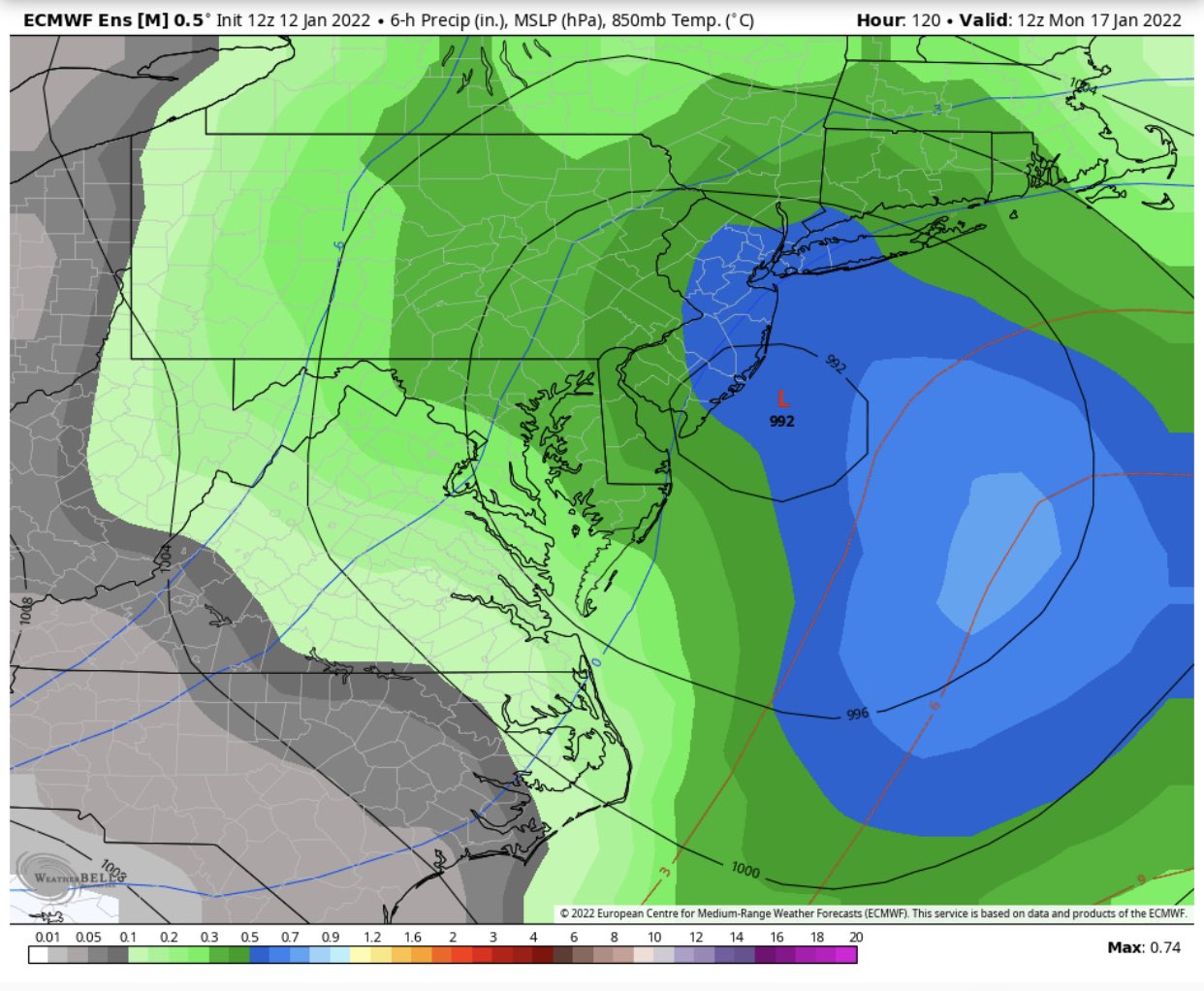
Well I can say one thing, if this is all snow if it can be a bit more offshore it sure is juiced, thats a lot of heavy precip!!amugs wrote:GEFS and Euro same camp in the mean
jmanley32- Senior Enthusiast
- Posts : 20517
Reputation : 108
Join date : 2013-12-12
Age : 42
Location : Yonkers, NY
rb924119 and phil155 like this post
Re: Momentum building for possible storm on JAN 16th?
![]() by phil155 Wed Jan 12, 2022 3:16 pm
by phil155 Wed Jan 12, 2022 3:16 pm
jmanley32 wrote:Well I can say one thing, if this is all snow if it can be a bit more offshore it sure is juiced, thats a lot of heavy precip!!amugs wrote:GEFS and Euro same camp in the mean
Agreed 100%, if that is all snow it would be a big snow maker
phil155- Pro Enthusiast
- Posts : 475
Reputation : 4
Join date : 2019-12-16
rb924119 likes this post
Re: Momentum building for possible storm on JAN 16th?
![]() by Lnda23 Wed Jan 12, 2022 3:46 pm
by Lnda23 Wed Jan 12, 2022 3:46 pm

Lnda23- Posts : 30
Reputation : 3
Join date : 2013-01-08
Location : Garwood, NJ
rb924119 and jmanley32 like this post
Re: Momentum building for possible storm on JAN 16th?
![]() by mikeypizano Wed Jan 12, 2022 4:08 pm
by mikeypizano Wed Jan 12, 2022 4:08 pm
Lnda23 wrote:Feels like this one might turn out to be memorable. Just a feeling!
Or, a complete and utter failure...
mikeypizano- Pro Enthusiast
- Posts : 1118
Reputation : 66
Join date : 2017-01-05
Age : 35
Location : Wilkes-Barre/Scranton, PA
Zhukov1945 and phil155 like this post
Re: Momentum building for possible storm on JAN 16th?
![]() by Irish Wed Jan 12, 2022 5:07 pm
by Irish Wed Jan 12, 2022 5:07 pm

Irish- Pro Enthusiast
- Posts : 788
Reputation : 19
Join date : 2019-01-16
Age : 45
Location : Old Bridge, NJ
Re: Momentum building for possible storm on JAN 16th?
![]() by heehaw453 Wed Jan 12, 2022 5:19 pm
by heehaw453 Wed Jan 12, 2022 5:19 pm

heehaw453- Advanced Forecaster
- Posts : 3906
Reputation : 86
Join date : 2014-01-20
Location : Bedminster Township, PA Elevation 600' ASL
rb924119 likes this post
Page 7 of 23 • 1 ... 6, 7, 8 ... 15 ... 23 ![]()
|
|
|