
 Search
Momentum building for possible storm on JAN 16th?
Page 6 of 23 •  1 ... 5, 6, 7 ... 14 ... 23
 ![]()
Re: Momentum building for possible storm on JAN 16th?
![]() by heehaw453 Wed Jan 12, 2022 8:26 am
by heehaw453 Wed Jan 12, 2022 8:26 am
heehaw453- Advanced Forecaster

- Posts : 3906
Join date : 2014-01-20
rb924119 likes this post
Re: Momentum building for possible storm on JAN 16th?
![]() by heehaw453 Wed Jan 12, 2022 8:28 am
by heehaw453 Wed Jan 12, 2022 8:28 am
heehaw453- Advanced Forecaster
- Posts : 3906
Join date : 2014-01-20
rb924119 likes this post
Re: Momentum building for possible storm on JAN 16th?
![]() by Frank_Wx Wed Jan 12, 2022 8:29 am
by Frank_Wx Wed Jan 12, 2022 8:29 am
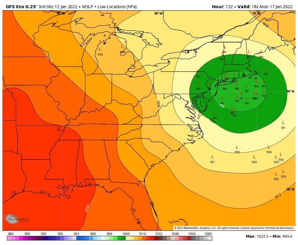
This morning's GFS valid Sunday morning:

Monday's GFS valid Sunday morning:

The blues have been replaced with reds. Basically, where we once saw lower heights as a result of the -NAO block is now replaced by positive heights (High Pressure). This single change is what's allowing our storm system to cut west. Unfortunately, changes like this are difficult to reverse. I think our best bet is for the Nor'easter to phase earlier and make that hook left into Canada again, which acts as our 50-50 low.
_________________
_______________________________________________________________________________________________________
CLICK HERE to view NJ Strong Snowstorm Classifications

Frank_Wx- Godzilla Seeker

- Posts : 21305
Reputation : 328
Join date : 2013-01-05
Age : 31
Location : Jersey City, NJ -

rb924119 likes this post
Re: Momentum building for possible storm on JAN 16th?
![]() by mmanisca Wed Jan 12, 2022 8:34 am
by mmanisca Wed Jan 12, 2022 8:34 am
Frank_Wx wrote:Focus your eyes on northern New England/Maine when you compare these two MSLP maps.
This morning's GFS valid Sunday morning:
Monday's GFS valid Sunday morning:
The blues have been replaced with reds. Basically, where we once saw lower heights as a result of the -NAO block is now replaced by positive heights (High Pressure). This single change is what's allowing our storm system to cut west. Unfortunately, changes like this are difficult to reverse. I think our best bet is for the Nor'easter to phase earlier and make that hook left into Canada again, which acts as our 50-50 low.
Great observation Frank, that is key. The only hope is that the modeling has the dynamics of the high incorrect, cause if it's right then were not looking good.

mmanisca- Pro Enthusiast

- Posts : 298
Reputation : 3
Join date : 2013-01-23
Age : 65
Location : Deer Park, Long Island
Re: Momentum building for possible storm on JAN 16th?
![]() by heehaw453 Wed Jan 12, 2022 8:45 am
by heehaw453 Wed Jan 12, 2022 8:45 am
Frank_Wx wrote:Focus your eyes on northern New England/Maine when you compare these two MSLP maps.
This morning's GFS valid Sunday morning:
Monday's GFS valid Sunday morning:
The blues have been replaced with reds. Basically, where we once saw lower heights as a result of the -NAO block is now replaced by positive heights (High Pressure). This single change is what's allowing our storm system to cut west. Unfortunately, changes like this are difficult to reverse. I think our best bet is for the Nor'easter to phase earlier and make that hook left into Canada again, which acts as our 50-50 low.
That is a good point. The blocking a few days ago was more western and now it's more eastern based. This allow a ridge connection from arctic right into NE which just lifts resistance out. Clearly see the arctic ridge connection here. I still argue though there is time for change. The Low could vertically stack and move just ever so slightly east and then your WAA would be mitigated. Mother nature will always surprise.
00Z Euro

heehaw453- Advanced Forecaster
- Posts : 3906
Reputation : 86
Join date : 2014-01-20
Location : Bedminster Township, PA Elevation 600' ASL
rb924119 likes this post
Re: Momentum building for possible storm on JAN 16th?
![]() by amugs Wed Jan 12, 2022 9:01 am
by amugs Wed Jan 12, 2022 9:01 am
Seems the GFS is going with the two most extreme eastward LP as you can see on the map - there is a westward lean on this by over a dozen members
_________________
Mugs
AKA:King: Snow Weenie
Self Proclaimed
WINTER 2014-15 : 55.12" +.02 for 6 coatings (avg. 35")
WINTER 2015-16 Total - 29.8" (Avg 35")
WINTER 2016-17 : 39.5" so far

amugs- Advanced Forecaster - Mod

- Posts : 15093
Reputation : 213
Join date : 2013-01-07
Age : 54
Location : Hillsdale,NJ
Re: Momentum building for possible storm on JAN 16th?
![]() by sroc4 Wed Jan 12, 2022 9:16 am
by sroc4 Wed Jan 12, 2022 9:16 am
Timing and strength of all the energy involved with the system itself, out in front of the system, and behind the system is far from know yet. Heck. The energy that is Friday’s apparent swing and miss system is just this morning coming onshore in northern Canada this morning(which I still think eastern sections has a shot at this one). The energy behind our Monday system is even further out so it’s exact strength and timing with respect to our system is far from known.
For now we let the weenies jump and we sit back and watch, then we will start to see how the modeling actually evolves. I agree with heehaw where this may be one of those situations where literally within 36 hours models are walking the track to its final destination.
_________________
"In weather and in life, there's no winning and losing; there's only winning and learning."
WINTER 2012/2013 TOTALS 43.65"WINTER 2017/2018 TOTALS 62.85" WINTER 2022/2023 TOTALS 4.9"
WINTER 2013/2014 TOTALS 64.85"WINTER 2018/2019 TOTALS 14.25" WINTER 2023/2024 TOTALS 13.1"
WINTER 2014/2015 TOTALS 71.20"WINTER 2019/2020 TOTALS 6.35"
WINTER 2015/2016 TOTALS 35.00"WINTER 2020/2021 TOTALS 37.75"
WINTER 2016/2017 TOTALS 42.25"WINTER 2021/2022 TOTALS 31.65"

sroc4- Admin
- Posts : 8331
Reputation : 301
Join date : 2013-01-07
Location : Wading River, LI
amugs, rb924119, weatherwatchermom and Hardwaremike like this post
Re: Momentum building for possible storm on JAN 16th?
![]() by amugs Wed Jan 12, 2022 9:38 am
by amugs Wed Jan 12, 2022 9:38 am
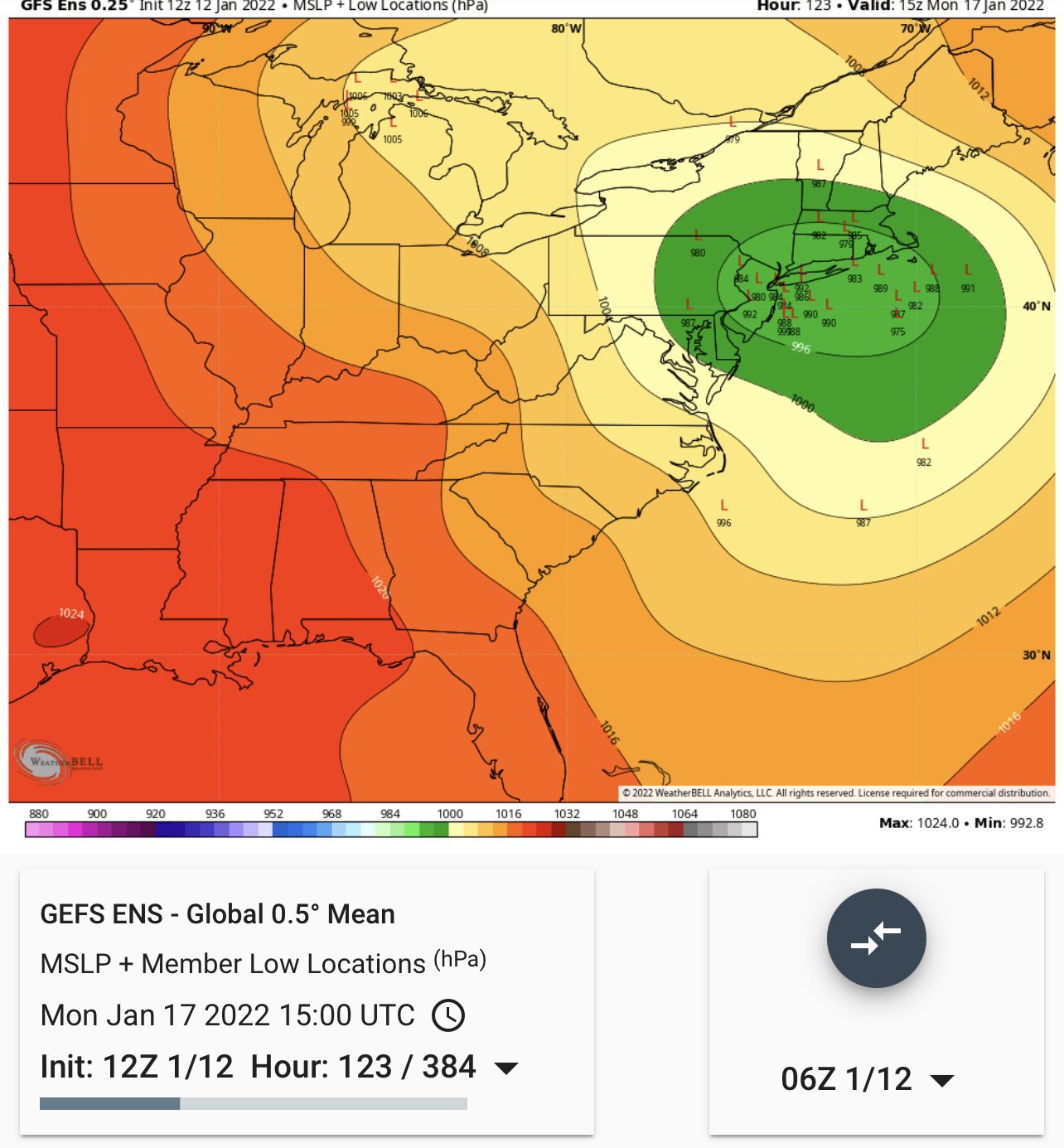
#Uncertainty in weekend storm...Its in Pac NW now. Has to travel >3,000 miles to East Coast Monday, thru Canadian/US Rockies, Southern Plains, Southeast. Each red # is the location and MSLP of each GEFS emsemble member. Watch spread grow in time. #winter pic.twitter.com/AukrasNKwp
— Tom Niziol (@TomNiziol) January 12, 2022
_________________
Mugs
AKA:King: Snow Weenie
Self Proclaimed
WINTER 2014-15 : 55.12" +.02 for 6 coatings (avg. 35")
WINTER 2015-16 Total - 29.8" (Avg 35")
WINTER 2016-17 : 39.5" so far
amugs- Advanced Forecaster - Mod
- Posts : 15093
Reputation : 213
Join date : 2013-01-07
Age : 54
Location : Hillsdale,NJ
rb924119 likes this post
Re: Momentum building for possible storm on JAN 16th?
![]() by amugs Wed Jan 12, 2022 11:04 am
by amugs Wed Jan 12, 2022 11:04 am

_________________
Mugs
AKA:King: Snow Weenie
Self Proclaimed
WINTER 2014-15 : 55.12" +.02 for 6 coatings (avg. 35")
WINTER 2015-16 Total - 29.8" (Avg 35")
WINTER 2016-17 : 39.5" so far
amugs- Advanced Forecaster - Mod
- Posts : 15093
Reputation : 213
Join date : 2013-01-07
Age : 54
Location : Hillsdale,NJ
Re: Momentum building for possible storm on JAN 16th?
![]() by sroc4 Wed Jan 12, 2022 11:13 am
by sroc4 Wed Jan 12, 2022 11:13 am
_________________
"In weather and in life, there's no winning and losing; there's only winning and learning."
WINTER 2012/2013 TOTALS 43.65"WINTER 2017/2018 TOTALS 62.85" WINTER 2022/2023 TOTALS 4.9"
WINTER 2013/2014 TOTALS 64.85"WINTER 2018/2019 TOTALS 14.25" WINTER 2023/2024 TOTALS 13.1"
WINTER 2014/2015 TOTALS 71.20"WINTER 2019/2020 TOTALS 6.35"
WINTER 2015/2016 TOTALS 35.00"WINTER 2020/2021 TOTALS 37.75"
WINTER 2016/2017 TOTALS 42.25"WINTER 2021/2022 TOTALS 31.65"
sroc4- Admin
- Posts : 8331
Reputation : 301
Join date : 2013-01-07
Location : Wading River, LI
rb924119 likes this post
Re: Momentum building for possible storm on JAN 16th?
![]() by sroc4 Wed Jan 12, 2022 11:19 am
by sroc4 Wed Jan 12, 2022 11:19 am
sroc4 wrote:Looks like we may need this to trend towards a Miller B to work out.
The circled energy is dropping in out of the arctic/polar regions SE. If we can get this little lobe of PV to trend a little faster and further SE over the Hudson Bay as indicated by the arrow, it will help press back on the heights in the east likely forcing an energy transfer off the coast before reaching our lat.
At least this is one way things can trend better for us.

_________________
"In weather and in life, there's no winning and losing; there's only winning and learning."
WINTER 2012/2013 TOTALS 43.65"WINTER 2017/2018 TOTALS 62.85" WINTER 2022/2023 TOTALS 4.9"
WINTER 2013/2014 TOTALS 64.85"WINTER 2018/2019 TOTALS 14.25" WINTER 2023/2024 TOTALS 13.1"
WINTER 2014/2015 TOTALS 71.20"WINTER 2019/2020 TOTALS 6.35"
WINTER 2015/2016 TOTALS 35.00"WINTER 2020/2021 TOTALS 37.75"
WINTER 2016/2017 TOTALS 42.25"WINTER 2021/2022 TOTALS 31.65"
sroc4- Admin
- Posts : 8331
Reputation : 301
Join date : 2013-01-07
Location : Wading River, LI
amugs and rb924119 like this post
Re: Momentum building for possible storm on JAN 16th?
![]() by heehaw453 Wed Jan 12, 2022 11:20 am
by heehaw453 Wed Jan 12, 2022 11:20 am
sroc4 wrote:Looks like we may need this to trend towards a Miller B to work out.
Looking at the GFS it kind of shows where the energy splits. Due to the temp contrast it's going to probably thump hard for a bit. The ULL can't get anywhere near Mason Dixon Line though otherwise mid levels will flood. NW of 95 have best shot at sig snow with this ATTM. I don't think there's much modelling to contradict that now. Things can still work out, but it's going to get some adjustments for coastal plain to get decent snows.
heehaw453- Advanced Forecaster
- Posts : 3906
Reputation : 86
Join date : 2014-01-20
Location : Bedminster Township, PA Elevation 600' ASL
rb924119 likes this post
Re: Momentum building for possible storm on JAN 16th?
![]() by MattyICE Wed Jan 12, 2022 11:22 am
by MattyICE Wed Jan 12, 2022 11:22 am
MattyICE- Advanced Forecaster
- Posts : 249
Reputation : 6
Join date : 2017-11-10
Age : 38
Location : Clifton, NJ (Eastern Passaic County)
rb924119 likes this post
Re: Momentum building for possible storm on JAN 16th?
![]() by nutleyblizzard Wed Jan 12, 2022 11:27 am
by nutleyblizzard Wed Jan 12, 2022 11:27 am
That GFS run looked wonky to me. You have a primary down in NC moving due east making a beeline towards the coast, when it abruptly moves due north into Pennsylvania. Don’t think I’m buying that. My best guess is the GFS is trending towards a miller B with a coastal transfer. Otherwise a slight improvement from 06z. Snow output increased a bit too. Waiting on the ensembles.sroc4 wrote:sroc4 wrote:Looks like we may need this to trend towards a Miller B to work out.
The circled energy is dropping in out of the arctic/polar regions SE. If we can get this little lobe of PV to trend a little faster and further SE over the Hudson Bay as indicated by the arrow, it will help press back on the heights in the east likely forcing an energy transfer off the coast before reaching our lat.
At least this is one way things can trend better for us.

nutleyblizzard- Senior Enthusiast

- Posts : 1952
Reputation : 41
Join date : 2014-01-30
Age : 58
Location : Nutley, new jersey
amugs likes this post
Re: Momentum building for possible storm on JAN 16th?
![]() by heehaw453 Wed Jan 12, 2022 11:33 am
by heehaw453 Wed Jan 12, 2022 11:33 am
MattyICE wrote:Plenty of time to trend. I’d like to hope that we have seen the pendulum finish its far left swing. I do think we can do things to trend back further East, but honestly only so much. I think the souther slider or coastal scraper idea is nearly off the table. At this point I think the best we might muster is a true just inland runner track that might get us some moderate to even significant accumulations via a front end thump before an inevitable changeover to slop. That high pressure can trend stronger all it wants, if there’s no 50/50 low to hold it in it WILL scoot off the New England coast and our mid-levels WILL warm significantly due to Synoptics. Pick your poison, but I’m not looking for ways to get this back all the way to a benchmark bomb that plasters the whole board with 1-2’ of snow. I’m looking at cold air damming, and enhanced confluence and a HP that hangs on a bit longer BEFORE the scoot to see if we can maximize some front end frozen QPF. IF I’m wrong I’ll be thrilled and will gladly take my 1-2’ of all snow! Plenty of time for changes, and these are just my general amateur thoughts.
The high will provide good cold air for an initial thump. That could make a difference of a few extra inches for some that turn to rain. The problem is resistance of the northward trajectory of the ULL. Maybe trending weaker with less s/w action or potentially splitting, but if it gets to Mason Dixon line still fairly intact we're going to rain fairly quickly. The good thing is adjustments at this range can be made, but we got to start seeing them...
heehaw453- Advanced Forecaster
- Posts : 3906
Reputation : 86
Join date : 2014-01-20
Location : Bedminster Township, PA Elevation 600' ASL
rb924119 likes this post
Re: Momentum building for possible storm on JAN 16th?
![]() by heehaw453 Wed Jan 12, 2022 11:51 am
by heehaw453 Wed Jan 12, 2022 11:51 am

heehaw453- Advanced Forecaster
- Posts : 3906
Reputation : 86
Join date : 2014-01-20
Location : Bedminster Township, PA Elevation 600' ASL
rb924119 likes this post
Re: Momentum building for possible storm on JAN 16th?
![]() by amugs Wed Jan 12, 2022 11:56 am
by amugs Wed Jan 12, 2022 11:56 am
_________________
Mugs
AKA:King: Snow Weenie
Self Proclaimed
WINTER 2014-15 : 55.12" +.02 for 6 coatings (avg. 35")
WINTER 2015-16 Total - 29.8" (Avg 35")
WINTER 2016-17 : 39.5" so far
amugs- Advanced Forecaster - Mod
- Posts : 15093
Reputation : 213
Join date : 2013-01-07
Age : 54
Location : Hillsdale,NJ
Re: Momentum building for possible storm on JAN 16th?
![]() by sroc4 Wed Jan 12, 2022 12:14 pm
by sroc4 Wed Jan 12, 2022 12:14 pm
sroc4 wrote:sroc4 wrote:Looks like we may need this to trend towards a Miller B to work out.
The circled energy is dropping in out of the arctic/polar regions SE. If we can get this little lobe of PV to trend a little faster and further SE over the Hudson Bay as indicated by the arrow, it will help press back on the heights in the east likely forcing an energy transfer off the coast before reaching our lat.
At least this is one way things can trend better for us.
You can see the CMC is further SE with the circled energy I highlighted with the GFS. Baby steps. CMC snow line and totals has shifted S&E relative to its 00z. Im not sure that we can get all the way beack to the BM bomb for all either, but perhaps a trend to longer and longer front end thump and a track just inside the BM.


_________________
"In weather and in life, there's no winning and losing; there's only winning and learning."
WINTER 2012/2013 TOTALS 43.65"WINTER 2017/2018 TOTALS 62.85" WINTER 2022/2023 TOTALS 4.9"
WINTER 2013/2014 TOTALS 64.85"WINTER 2018/2019 TOTALS 14.25" WINTER 2023/2024 TOTALS 13.1"
WINTER 2014/2015 TOTALS 71.20"WINTER 2019/2020 TOTALS 6.35"
WINTER 2015/2016 TOTALS 35.00"WINTER 2020/2021 TOTALS 37.75"
WINTER 2016/2017 TOTALS 42.25"WINTER 2021/2022 TOTALS 31.65"
sroc4- Admin
- Posts : 8331
Reputation : 301
Join date : 2013-01-07
Location : Wading River, LI
rb924119 likes this post
Re: Momentum building for possible storm on JAN 16th?
![]() by aiannone Wed Jan 12, 2022 12:17 pm
by aiannone Wed Jan 12, 2022 12:17 pm
sroc4 wrote:sroc4 wrote:sroc4 wrote:Looks like we may need this to trend towards a Miller B to work out.
The circled energy is dropping in out of the arctic/polar regions SE. If we can get this little lobe of PV to trend a little faster and further SE over the Hudson Bay as indicated by the arrow, it will help press back on the heights in the east likely forcing an energy transfer off the coast before reaching our lat.
At least this is one way things can trend better for us.
You can see the CMC is further SE with the circled energy I highlighted with the GFS. Baby steps. CMC snow line and totals has shifted S&E relative to its 00z. Im not sure that we can get all the way beack to the BM bomb for all either, but perhaps a trend to longer and longer front end thump and a track just inside the BM.
That's actually 0z. 12z CMC will be significantly delayed. They had a massive outage
_________________
-Alex Iannone-

aiannone- Senior Enthusiast - Mod
- Posts : 4813
Reputation : 92
Join date : 2013-01-07
Location : Saint James, LI (Northwest Suffolk Co.)
Re: Momentum building for possible storm on JAN 16th?
![]() by sroc4 Wed Jan 12, 2022 12:18 pm
by sroc4 Wed Jan 12, 2022 12:18 pm
_________________
"In weather and in life, there's no winning and losing; there's only winning and learning."
WINTER 2012/2013 TOTALS 43.65"WINTER 2017/2018 TOTALS 62.85" WINTER 2022/2023 TOTALS 4.9"
WINTER 2013/2014 TOTALS 64.85"WINTER 2018/2019 TOTALS 14.25" WINTER 2023/2024 TOTALS 13.1"
WINTER 2014/2015 TOTALS 71.20"WINTER 2019/2020 TOTALS 6.35"
WINTER 2015/2016 TOTALS 35.00"WINTER 2020/2021 TOTALS 37.75"
WINTER 2016/2017 TOTALS 42.25"WINTER 2021/2022 TOTALS 31.65"
sroc4- Admin
- Posts : 8331
Reputation : 301
Join date : 2013-01-07
Location : Wading River, LI
Re: Momentum building for possible storm on JAN 16th?
![]() by Frank_Wx Wed Jan 12, 2022 12:37 pm
by Frank_Wx Wed Jan 12, 2022 12:37 pm
_________________
_______________________________________________________________________________________________________
CLICK HERE to view NJ Strong Snowstorm Classifications
Frank_Wx- Godzilla Seeker
- Posts : 21305
Reputation : 328
Join date : 2013-01-05
Age : 31
Location : Jersey City, NJ -
sroc4, rb924119 and heehaw453 like this post
Re: Momentum building for possible storm on JAN 16th?
![]() by sroc4 Wed Jan 12, 2022 12:44 pm
by sroc4 Wed Jan 12, 2022 12:44 pm
Frank_Wx wrote:I think the southern slider scenario can be eliminated. We’re down to three…apps runner, coastal hugger or coastal
For me, and I am going to be a little selfish just for a moment here if I may, I would like the perfect scenario to be a massive front end thump for all, and just as the warm air begins to get close it Miller B's to just at or SE of the BM setting up the CCB right over my house, just like Nemo in Feb 2013. I ended with just under 30".
https://weather.com/storms/winter/nemo/news/winter-storm-nemo-reports-20130208

_________________
"In weather and in life, there's no winning and losing; there's only winning and learning."
WINTER 2012/2013 TOTALS 43.65"WINTER 2017/2018 TOTALS 62.85" WINTER 2022/2023 TOTALS 4.9"
WINTER 2013/2014 TOTALS 64.85"WINTER 2018/2019 TOTALS 14.25" WINTER 2023/2024 TOTALS 13.1"
WINTER 2014/2015 TOTALS 71.20"WINTER 2019/2020 TOTALS 6.35"
WINTER 2015/2016 TOTALS 35.00"WINTER 2020/2021 TOTALS 37.75"
WINTER 2016/2017 TOTALS 42.25"WINTER 2021/2022 TOTALS 31.65"
sroc4- Admin
- Posts : 8331
Reputation : 301
Join date : 2013-01-07
Location : Wading River, LI
Re: Momentum building for possible storm on JAN 16th?
![]() by nutleyblizzard Wed Jan 12, 2022 12:47 pm
by nutleyblizzard Wed Jan 12, 2022 12:47 pm
Still not buying the apps runner since in recent years it’s been a rare and anomalous track. My goalposts have shrunk with this storm. I’m thinking anywhere from an inside the BM to a NYC track.Frank_Wx wrote:I think the southern slider scenario can be eliminated. We’re down to three…apps runner, coastal hugger or coastal
nutleyblizzard- Senior Enthusiast
- Posts : 1952
Reputation : 41
Join date : 2014-01-30
Age : 58
Location : Nutley, new jersey
sroc4, amugs and rb924119 like this post
Re: Momentum building for possible storm on JAN 16th?
![]() by jmanley32 Wed Jan 12, 2022 12:51 pm
by jmanley32 Wed Jan 12, 2022 12:51 pm
That storm was insane, forget what I got I know it was somewhat of a let down I was in that second shade of purple, my parents got the death band with 40 inches in CT!! I think that was a record for the area. They said they had never seen it snow so long and so hard. Snow drifted up fiurst gloor windows. It is okay to be selfish, if I can get 6-12 out of this I would be happy, I also won't be entirely surprised if it doesn't work out but heres hoping!sroc4 wrote:Frank_Wx wrote:I think the southern slider scenario can be eliminated. We’re down to three…apps runner, coastal hugger or coastal
For me, and I am going to be a little selfish just for a moment here if I may, I would like the perfect scenario to be a massive front end thump for all, and just as the warm air begins to get close it Miller B's to just at or SE of the BM setting up the CCB right over my house, just like Nemo in Feb 2013. I ended with just under 30".
https://weather.com/storms/winter/nemo/news/winter-storm-nemo-reports-20130208
Edit: I actually did pretty well, I think I got like 12-15, and I remember the winds were insane so I got both my weather obsessions : ) I would be fine with a Nemo again even if you bank. I consider 6+ a bank for these parts.

jmanley32- Senior Enthusiast
- Posts : 20513
Reputation : 108
Join date : 2013-12-12
Age : 42
Location : Yonkers, NY
Re: Momentum building for possible storm on JAN 16th?
![]() by heehaw453 Wed Jan 12, 2022 12:55 pm
by heehaw453 Wed Jan 12, 2022 12:55 pm
heehaw453- Advanced Forecaster
- Posts : 3906
Reputation : 86
Join date : 2014-01-20
Location : Bedminster Township, PA Elevation 600' ASL
Re: Momentum building for possible storm on JAN 16th?
![]() by sroc4 Wed Jan 12, 2022 12:56 pm
by sroc4 Wed Jan 12, 2022 12:56 pm
jmanley32 wrote:That storm was insane, forget what I got I know it was somewhat of a let down I was in that second shade of purple, my parents got the death band with 40 inches in CT!! I think that was a record for the area. They said they had never seen it snow so long and so hard. Snow drifted up fiurst gloor windows. It is okay to be selfish, if I can get 6-12 out of this I would be happy, I also won't be entirely surprised if it doesn't work out but heres hoping!sroc4 wrote:Frank_Wx wrote:I think the southern slider scenario can be eliminated. We’re down to three…apps runner, coastal hugger or coastal
For me, and I am going to be a little selfish just for a moment here if I may, I would like the perfect scenario to be a massive front end thump for all, and just as the warm air begins to get close it Miller B's to just at or SE of the BM setting up the CCB right over my house, just like Nemo in Feb 2013. I ended with just under 30".
https://weather.com/storms/winter/nemo/news/winter-storm-nemo-reports-20130208
Edit: I actually did pretty well, I think I got like 12-15, and I remember the winds were insane so I got both my weather obsessions : ) I would be fine with a Nemo again even if you bank. I consider 6+ a bank for these parts.
Here’s to Hoping Jon

_________________
"In weather and in life, there's no winning and losing; there's only winning and learning."
WINTER 2012/2013 TOTALS 43.65"WINTER 2017/2018 TOTALS 62.85" WINTER 2022/2023 TOTALS 4.9"
WINTER 2013/2014 TOTALS 64.85"WINTER 2018/2019 TOTALS 14.25" WINTER 2023/2024 TOTALS 13.1"
WINTER 2014/2015 TOTALS 71.20"WINTER 2019/2020 TOTALS 6.35"
WINTER 2015/2016 TOTALS 35.00"WINTER 2020/2021 TOTALS 37.75"
WINTER 2016/2017 TOTALS 42.25"WINTER 2021/2022 TOTALS 31.65"
sroc4- Admin
- Posts : 8331
Reputation : 301
Join date : 2013-01-07
Location : Wading River, LI
rb924119, essexcountypete, heehaw453 and Bwtr like this post
Re: Momentum building for possible storm on JAN 16th?
![]() by jmanley32 Wed Jan 12, 2022 12:58 pm
by jmanley32 Wed Jan 12, 2022 12:58 pm
In between would be better than a NYC runner, that would suck. I dunno I have a tingling that as we close in on the 3 day we are go see some SR craziness. The fact that a OTS is off table is great, the fact that a apps runner is not is not great. But lets hope we can get that off the table too, as scott said baby steps.nutleyblizzard wrote:Still not buying the apps runner since in recent years it’s been a rare and anomalous track. My goalposts have shrunk with this storm. I’m thinking anywhere from an inside the BM to a NYC track.Frank_Wx wrote:I think the southern slider scenario can be eliminated. We’re down to three…apps runner, coastal hugger or coastal
Love this movie, loved it before I became a therapist.
https://www.youtube.com/watch?v=Yl6s6DGapug
jmanley32- Senior Enthusiast
- Posts : 20513
Reputation : 108
Join date : 2013-12-12
Age : 42
Location : Yonkers, NY
Page 6 of 23 • 1 ... 5, 6, 7 ... 14 ... 23 ![]()
|
|
|