
 Search
Long Range Discussion 23.0
Page 1 of 26 • 1, 2, 3 ... 13 ... 26 ![]()

Long Range Discussion 23.0
![]() by Frank_Wx Tue Jan 18, 2022 3:23 pm
by Frank_Wx Tue Jan 18, 2022 3:23 pm
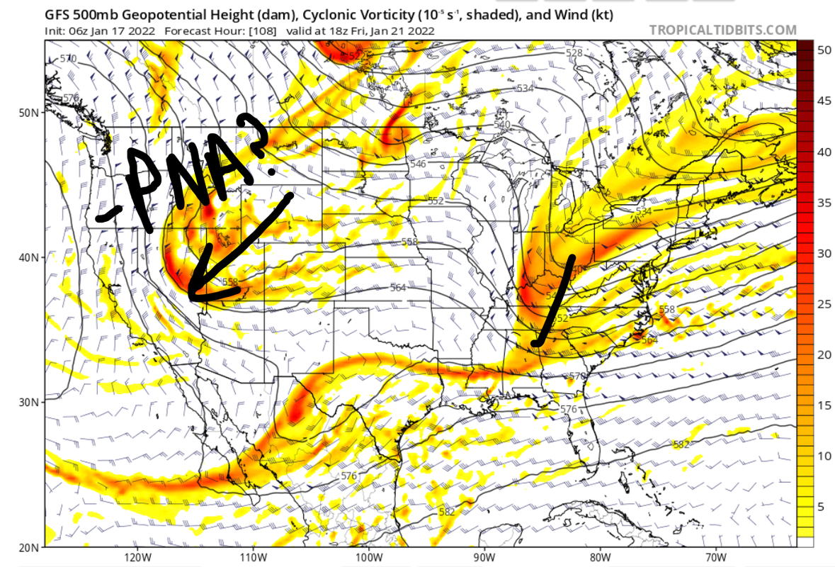
Frank_Wx wrote:The next two storm threats are planned for the 22nd-23rd and 25th-27th.
January 23rd:
This one had the appearance of a potentially big system, but over the last 48 hours we have seen this threat fizzle just a little bit. Below is a look at the GFS upper air map valid for Friday the 21st. You can clearly see a trough and associated energy entering the eastern CONUS, but the trough is positively tilted and the energy is a little strung out. There's 2 reasons for that:
1. There's a very strong piece of northern energy that is cutting off over the western U.S., which is bringing the PNA down to negative. This prevents the trough over the east from consolidating the energy at the base and going neutral-negative. There's also another piece of energy over Texas that is being held back. So, we have all this upper energy being held back over western areas of the U.S. which means there's no opportunity for our northern energy to phase.
2. I did not denote it on the map, but if you look in south-central Canada near the Great Lakes we have a ridge rolling east which is also acting to disrupt the trough over the east. That's because just N&W of there we have even more pieces of upper energy coming out of the Pacific. At this time, the AO and NAO are also positive.
The end result is a strung out mess of energy over the east coast, and a surface low positioned well off the coast. So, I am not very enthused about this threat unless we can get the southern short waves over SW CONUS to eject east instead of getting held back. If that happens, and we end up seeing a phase, it could capture the trough and help bring a low up the coast. There's still time for these trends to occur. Let's see what happens over the next 2-3 days.
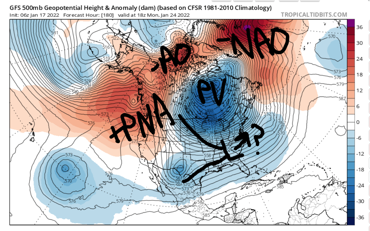
January 25th-1st:
I've mentioned it earlier, but this is the time period I am favoring over the 23rd at this time. By this point, we are seeing some very interesting developments at 500mb.
1). -AO and -NAO return
2). -EPO/+PNA are emerging
3). PV is centered over the Hudson Bay
Remember that ULL I circled in the other graphic in relation to the 23rd storm? Well by the time we get to the 25th, it finally moves out of the southwest U.S. and follows the jet east-northeast. Because of the aforementioned changes aloft, there's a very good chance this southern energy meets up with northern energy to create our next storm. I won't elaborate more beyond this point, but I really do like the upper level picture. Assuming these features do not change (i.e. NAO does not trend back to positive, etc.) then I am excited about a storm.
_________________
_______________________________________________________________________________________________________
CLICK HERE to view NJ Strong Snowstorm Classifications

Frank_Wx- Godzilla Seeker

- Posts : 21305
Reputation : 328
Join date : 2013-01-05
Age : 31
Location : Jersey City, NJ -

Re: Long Range Discussion 23.0
![]() by rb924119 Wed Jan 19, 2022 1:30 am
by rb924119 Wed Jan 19, 2022 1:30 am
First: I’d like to do a postmortem analysis of our last storm, as I’d like to apologize for leading us astray with that in the closing day or two. No excuse for my errors, regardless of how busy I am. In hindsight, I should have seen it once that secondary vort max became a major player. So, I’d like to do a relatively brief discussion rehashing that so that I/we can all learn from that.
Second: I’d like to do a relatively brief interim update on the status of the long range evolution and how I think we are progressing. Overall, I am very happy with where we are, and where we are going over the next 2-3 weeks. My focus will be on once we get into February and beyond. From early musings, I think that my original ideas still look really, really good, but I should have some time to look more closely and give a full discussion. I know the models are trying to retrograde our pattern a bit as we get into the start of next month, and it fits the factors that I’m looking at. However, those same factors are also indicating that this should NOT be a complete reversal of the pattern again, but more of an intermission. Although the pattern won’t be completely progressive, for our intents and purposes, I think it will be, with alternating flow patterns that leave us near average in the temperature department. I think this intermission lasts one to two weeks (two weeks maximum) before winter returns for round two which should bring us to near the start of March. We may relax the pattern again to open March, but then I think we go out swinging after that into the end of March. Again, preliminary thoughts here, but overall I like what I’m seeing in the extended, and I think the ideas originally presented for this season’s evolution largely remain on track, and the idea of staying “pretty much locked in through the remainder of winter with only limited warmth” is right on track.
rb924119- Meteorologist

- Posts : 6890
Reputation : 194
Join date : 2013-02-06
Age : 32
Location : Greentown, Pa
amugs likes this post
Re: Long Range Discussion 23.0
![]() by Radz Wed Jan 19, 2022 6:41 am
by Radz Wed Jan 19, 2022 6:41 am

Radz- Pro Enthusiast

- Posts : 1028
Reputation : 17
Join date : 2013-01-12
Location : Cortlandt Manor NY
bloc1357, heehaw453, SENJsnowman and phil155 like this post
Re: Long Range Discussion 23.0
![]() by heehaw453 Wed Jan 19, 2022 1:11 pm
by heehaw453 Wed Jan 19, 2022 1:11 pm
heehaw453- Advanced Forecaster

- Posts : 3906
Reputation : 86
Join date : 2014-01-20
Location : Bedminster Township, PA Elevation 600' ASL
Re: Long Range Discussion 23.0
![]() by amugs Wed Jan 19, 2022 2:24 pm
by amugs Wed Jan 19, 2022 2:24 pm

_________________
Mugs
AKA:King: Snow Weenie
Self Proclaimed
WINTER 2014-15 : 55.12" +.02 for 6 coatings (avg. 35")
WINTER 2015-16 Total - 29.8" (Avg 35")
WINTER 2016-17 : 39.5" so far

amugs- Advanced Forecaster - Mod

- Posts : 15093
Reputation : 213
Join date : 2013-01-07
Age : 54
Location : Hillsdale,NJ
Re: Long Range Discussion 23.0
![]() by phil155 Wed Jan 19, 2022 2:34 pm
by phil155 Wed Jan 19, 2022 2:34 pm
amugs wrote:Here is the sucker look - who wants to ride this one??
It almost feels like the models are toying with us, trying to get hopes up only to crush that hope in the end
phil155- Pro Enthusiast
- Posts : 475
Reputation : 4
Join date : 2019-12-16
Re: Long Range Discussion 23.0
![]() by heehaw453 Wed Jan 19, 2022 2:55 pm
by heehaw453 Wed Jan 19, 2022 2:55 pm
amugs wrote:Here is the sucker look - who wants to ride this one??
GEFS H5 is of interest for this time period too.
heehaw453- Advanced Forecaster
- Posts : 3906
Reputation : 86
Join date : 2014-01-20
Location : Bedminster Township, PA Elevation 600' ASL
Re: Long Range Discussion 23.0
![]() by lglickman1 Wed Jan 19, 2022 3:13 pm
by lglickman1 Wed Jan 19, 2022 3:13 pm
heehaw453 wrote:amugs wrote:Here is the sucker look - who wants to ride this one??
GEFS H5 is of interest for this time period too.
This is for the 26th?
lglickman1- Pro Enthusiast
- Posts : 319
Reputation : 0
Join date : 2013-02-05
Location : New Rochelle, NY
Re: Long Range Discussion 23.0
![]() by heehaw453 Wed Jan 19, 2022 3:34 pm
by heehaw453 Wed Jan 19, 2022 3:34 pm
lglickman1 wrote:heehaw453 wrote:amugs wrote:Here is the sucker look - who wants to ride this one??
GEFS H5 is of interest for this time period too.
This is for the 26th?
Yep, in that general time frame of 26/27.
heehaw453- Advanced Forecaster
- Posts : 3906
Reputation : 86
Join date : 2014-01-20
Location : Bedminster Township, PA Elevation 600' ASL
Re: Long Range Discussion 23.0
![]() by SENJsnowman Wed Jan 19, 2022 3:57 pm
by SENJsnowman Wed Jan 19, 2022 3:57 pm
The thrill is in the hunt!!!! Got something to track for next week- I’m ready to roll! I Just can’t help it and I actually just love the moments of optimism, no matter how much the optimism crashes (every time
Again, speaking only for myself and I imagine that’s subject to change over time…but for now if there is at least one model to track (track, not hug) then ima be at the front of the line, every time. As an example, from December 1 - March 15, I pretty much check the Board first thing when I wake up, right before I go to sleep and several to several dozen times throughout each day depending how active it is that day. Without a looming threat, probably about 10-15 minutes a day tops. Within 5-6 days of a threat, I really have to monitor my time and make sure to stay productive (and present).
SENJsnowman- Senior Enthusiast

- Posts : 1186
Reputation : 61
Join date : 2017-01-06
Age : 51
Location : Bayville, NJ
Frank_Wx, sroc4, CPcantmeasuresnow, kalleg, essexcountypete, billg315, Irish and phil155 like this post
Re: Long Range Discussion 23.0
![]() by richb521 Wed Jan 19, 2022 4:40 pm
by richb521 Wed Jan 19, 2022 4:40 pm
richb521- Posts : 61
Reputation : 3
Join date : 2014-01-19
Age : 49
Location : Hillsborough, NJ
Re: Long Range Discussion 23.0
![]() by jmanley32 Wed Jan 19, 2022 6:04 pm
by jmanley32 Wed Jan 19, 2022 6:04 pm
LOL totally me, refresh refresh refresh lmaoSENJsnowman wrote:Just speaking for myself, and I’ve said this a few times on this board:
The thrill is in the hunt!!!! Got something to track for next week- I’m ready to roll! I Just can’t help it and I actually just love the moments of optimism, no matter how much the optimism crashes (every time).
Again, speaking only for myself and I imagine that’s subject to change over time…but for now if there is at least one model to track (track, not hug) then ima be at the front of the line, every time. As an example, from December 1 - March 15, I pretty much check the Board first thing when I wake up, right before I go to sleep and several to several dozen times throughout each day depending how active it is that day. Without a looming threat, probably about 10-15 minutes a day tops. Within 5-6 days of a threat, I really have to monitor my time and make sure to stay productive (and present).

jmanley32- Senior Enthusiast
- Posts : 20516
Reputation : 108
Join date : 2013-12-12
Age : 42
Location : Yonkers, NY
SENJsnowman likes this post
Re: Long Range Discussion 23.0
![]() by sroc4 Wed Jan 19, 2022 8:15 pm
by sroc4 Wed Jan 19, 2022 8:15 pm
richb521 wrote:Is the possible system of the 26-27th the timeframe some board members were thinking had a better chance of coming to fruition than the 22nd-23rd?
I d say this threat has about as much of a chance as this weekends chance had in the same time frame. There is just as many individual pieces of energy coming in at varying times and strengths both on the Atlantic side and pacific side. The one thing that is definitely a positive is there should be plenty of cold air around which is the very first ingredient needed. Just need the pieces to come together. Call it 50/50 at this stage.
_________________
"In weather and in life, there's no winning and losing; there's only winning and learning."
WINTER 2012/2013 TOTALS 43.65"WINTER 2017/2018 TOTALS 62.85" WINTER 2022/2023 TOTALS 4.9"
WINTER 2013/2014 TOTALS 64.85"WINTER 2018/2019 TOTALS 14.25" WINTER 2023/2024 TOTALS 13.1"
WINTER 2014/2015 TOTALS 71.20"WINTER 2019/2020 TOTALS 6.35"
WINTER 2015/2016 TOTALS 35.00"WINTER 2020/2021 TOTALS 37.75"
WINTER 2016/2017 TOTALS 42.25"WINTER 2021/2022 TOTALS 31.65"

sroc4- Admin
- Posts : 8331
Reputation : 301
Join date : 2013-01-07
Location : Wading River, LI
CPcantmeasuresnow, richb521 and phil155 like this post
Re: Long Range Discussion 23.0
![]() by Frank_Wx Wed Jan 19, 2022 8:45 pm
by Frank_Wx Wed Jan 19, 2022 8:45 pm
richb521 wrote:Is the possible system of the 26-27th the timeframe some board members were thinking had a better chance of coming to fruition than the 22nd-23rd?
Yes. That time frame (26th-1st) I feel good about for the reasons outlined
_________________
_______________________________________________________________________________________________________
CLICK HERE to view NJ Strong Snowstorm Classifications
Frank_Wx- Godzilla Seeker
- Posts : 21305
Reputation : 328
Join date : 2013-01-05
Age : 31
Location : Jersey City, NJ -
richb521 likes this post
Re: Long Range Discussion 23.0
![]() by SENJsnowman Thu Jan 20, 2022 12:39 am
by SENJsnowman Thu Jan 20, 2022 12:39 am
jmanley32 wrote:LOL totally me, refresh refresh refresh lmaoSENJsnowman wrote:Just speaking for myself, and I’ve said this a few times on this board:
The thrill is in the hunt!!!! Got something to track for next week- I’m ready to roll! I Just can’t help it and I actually just love the moments of optimism, no matter how much the optimism crashes (every time
Again, speaking only for myself and I imagine that’s subject to change over time…but for now if there is at least one model to track (track, not hug) then ima be at the front of the line, every time. As an example, from December 1 - March 15, I pretty much check the Board first thing when I wake up, right before I go to sleep and several to several dozen times throughout each day depending how active it is that day. Without a looming threat, probably about 10-15 minutes a day tops. Within 5-6 days of a threat, I really have to monitor my time and make sure to stay productive (and present).
OMG...if I can smell even the faintest hint of mothra potential coming my way...
I've wondered to myself on many occasions: Can Frank and the other Mods see how much I sign on and can they see how often I hit 'refresh, refresh, refresh'?! lol But in our defense b/w heehaw, mugsy and Sroc alone, many times the 'refresh, refresh, refresh' method works! lmao
SENJsnowman- Senior Enthusiast
- Posts : 1186
Reputation : 61
Join date : 2017-01-06
Age : 51
Location : Bayville, NJ
Re: Long Range Discussion 23.0
![]() by Frank_Wx Thu Jan 20, 2022 7:25 am
by Frank_Wx Thu Jan 20, 2022 7:25 am

Key features:
1. Polar Vortex over the NE quadrant of Hudson Bay
2. Trough over the eastern US
3. Upper level low spinning over SW US
4. Neutral to positive PNA
5. Negative EPO
The key feature to watch is the ULL - “blue blob” - in the SW US. This ULL will gradually move east-northeast early next week and develop a surface low once it crosses the Mississippi. The question becomes can this piece of southern energy phase with anything out of the Pacific/north? Right now I don’t think that will happen but all scenarios on the table. If a phase does not happen, we’re left with a fairly weaker storm system that could bring some wintry weather here on Tuesday. The negative NAO is east based and the flow on the backside of this system is fairly progressive with more short waves entering the country. Therefore, we’ll have to watch how far north the precip gets, and if it gets north, will it be snow? Models are indicating coastal plain may see their heights rise too much ahead of the incoming low. There’s no mechanism to keep the cold in place. But that would change if we see some phasing or a perfectly tracked LP.
The last period of interest will be next Friday all the way to Monday. In one or two of those days, we’ll be watching a potential coastal storm. Because of how active our pattern is with short wave after short wave, models won’t know which one to key in on until we get to mid next week. But, the PV we saw over the Hudson is retreating north and we’re seeing amplification of the PNA ridge. It’s not the greatest upper level map I’ve seen, but it’s intriguing to me because of the PNA/EPO couplet and NAO.

Beyond February 1st I won’t comment because the pattern goes into a state of flux. Literally models are changing their tune run to run.
_________________
_______________________________________________________________________________________________________
CLICK HERE to view NJ Strong Snowstorm Classifications
Frank_Wx- Godzilla Seeker
- Posts : 21305
Reputation : 328
Join date : 2013-01-05
Age : 31
Location : Jersey City, NJ -
Re: Long Range Discussion 23.0
![]() by mmanisca Thu Jan 20, 2022 7:55 am
by mmanisca Thu Jan 20, 2022 7:55 am
Frank_Wx wrote:I’ll provide a brief recap of what’s to watch for over the next 7-10 days. Here is the upper level map valid for this Sunday.
Key features:
1. Polar Vortex over the NE quadrant of Hudson Bay
2. Trough over the eastern US
3. Upper level low spinning over SW US
4. Neutral to positive PNA
5. Negative EPO
The key feature to watch is the ULL - “blue blob” - in the SW US. This ULL will gradually move east-northeast early next week and develop a surface low once it crosses the Mississippi. The question becomes can this piece of southern energy phase with anything out of the Pacific/north? Right now I don’t think that will happen but all scenarios on the table. If a phase does not happen, we’re left with a fairly weaker storm system that could bring some wintry weather here on Tuesday. The negative NAO is east based and the flow on the backside of this system is fairly progressive with more short waves entering the country. Therefore, we’ll have to watch how far north the precip gets, and if it gets north, will it be snow? Models are indicating coastal plain may see their heights rise too much ahead of the incoming low. There’s no mechanism to keep the cold in place. But that would change if we see some phasing or a perfectly tracked LP.
The last period of interest will be next Friday all the way to Monday. In one or two of those days, we’ll be watching a potential coastal storm. Because of how active our pattern is with short wave after short wave, models won’t know which one to key in on until we get to mid next week. But, the PV we saw over the Hudson is retreating north and we’re seeing amplification of the PNA ridge. It’s not the greatest upper level map I’ve seen, but it’s intriguing to me because of the PNA/EPO couplet and NAO.
Beyond February 1st I won’t comment because the pattern goes into a state of flux. Literally models are changing their tune run to run.
Frank nice write up here, thanks for the thouroughness as always. I do however want to go back to something I said in late December that it seems as though things continued to get pushed back. For the most part the winter has been a dud with the exception of the one storm this month that did give some folks a decent snowfall. You know a lot more than me so I wont go to task with you, but watching weather for so many years I've seen these kind of winters before where theres always something in the future that seems to fade away as we get closer to that time frame. Sometimes seasonal patterns are hard to break, but I hope Im wrong, and will be rooting against my feeling on this!

mmanisca- Pro Enthusiast
- Posts : 298
Reputation : 3
Join date : 2013-01-23
Age : 65
Location : Deer Park, Long Island
Re: Long Range Discussion 23.0
![]() by Frank_Wx Thu Jan 20, 2022 9:47 am
by Frank_Wx Thu Jan 20, 2022 9:47 am
Just because folks like myself, Ray, etc give some insights into the future, doesn’t mean it’s going to result in endless storms. It is very difficult to get a snowstorm to hit on the coast. All we do is show the pattern trends because obviously you need the cold first before anything else. It’s going to be cold through months end. Whether that coincides with any snow remains to be seen.
_________________
_______________________________________________________________________________________________________
CLICK HERE to view NJ Strong Snowstorm Classifications
Frank_Wx- Godzilla Seeker
- Posts : 21305
Reputation : 328
Join date : 2013-01-05
Age : 31
Location : Jersey City, NJ -
crippo84 likes this post
Re: Long Range Discussion 23.0
![]() by mmanisca Thu Jan 20, 2022 10:00 am
by mmanisca Thu Jan 20, 2022 10:00 am
mmanisca- Pro Enthusiast
- Posts : 298
Reputation : 3
Join date : 2013-01-23
Age : 65
Location : Deer Park, Long Island
Re: Long Range Discussion 23.0
![]() by MattyICE Thu Jan 20, 2022 10:04 am
by MattyICE Thu Jan 20, 2022 10:04 am
MattyICE- Advanced Forecaster
- Posts : 249
Reputation : 6
Join date : 2017-11-10
Age : 38
Location : Clifton, NJ (Eastern Passaic County)
SENJsnowman likes this post
Re: Long Range Discussion 23.0
![]() by heehaw453 Thu Jan 20, 2022 10:13 am
by heehaw453 Thu Jan 20, 2022 10:13 am

heehaw453- Advanced Forecaster
- Posts : 3906
Reputation : 86
Join date : 2014-01-20
Location : Bedminster Township, PA Elevation 600' ASL
Re: Long Range Discussion 23.0
![]() by heehaw453 Thu Jan 20, 2022 11:15 am
by heehaw453 Thu Jan 20, 2022 11:15 am

heehaw453- Advanced Forecaster
- Posts : 3906
Reputation : 86
Join date : 2014-01-20
Location : Bedminster Township, PA Elevation 600' ASL
Re: Long Range Discussion 23.0
![]() by heehaw453 Fri Jan 21, 2022 9:40 am
by heehaw453 Fri Jan 21, 2022 9:40 am
The 1/29-1/31 window IMO is a more legit threat. You have a western ridge that will develop and allow for several n/s s/w's to dive hard on their backside. But there in lies the problem wave spacing has been killing us this year for threats and I have no reason to believe this will be much different. I expect a storm to our s/e.
So that is the rest of January IMO a couple more threat windows and I won't be surprised to see us miss out on each of them. Sure there may be some nickel and dime things, but I don't think we hit the mark. That being said January has not been too bad as we've all seen a lot worse even if it doesn't snow too much more.
heehaw453- Advanced Forecaster
- Posts : 3906
Reputation : 86
Join date : 2014-01-20
Location : Bedminster Township, PA Elevation 600' ASL
SENJsnowman likes this post
Re: Long Range Discussion 23.0
![]() by rb924119 Fri Jan 21, 2022 9:47 am
by rb924119 Fri Jan 21, 2022 9:47 am
After the above stretch, I think winter returns pretty harshly, as we see a renewed Aleutian low/+PNA couplet, possibly gaining enough latitude with the PNA ridge to seed and reorient a new -EPO. This will take us right through the rest of February. With so much cold still available to us, once this pattern evolves, it should be more than enough to offset any early-month positive temperature departure (and then some).
I think March, however, gets tricksy, as we really start to change up atmospheric wavelengths in the Northern Hemisphere (they become shorter), and we will have competing atmospheric evolutions. On the whole, I think the CONUS biases below average temperatures with a “coast to coast” cold pattern. BUT, how we get there, I think, will be a wilddddd ride. I think we are going to see A LOT of west-based Atlantic domain blocking develop beginning in the opening days of the month. As a result, I think we are going to see a lot of “bowling ball” lows amplifying into the West Coast as the Stratosphere will be trying to enhance the Tropospheric trough out there, but the tropical forcing will be trying to enhance it over the central and eastern CONUS. So, I think you can envision how storms will amplify as they come into the West Coast, but then get cut off via repeated cyclonic wave breaking over the central CONUS, which will aid in the maintenance of the west-based Atlantic domain blocking. Now, at this time of year, it may not be a pattern that works exceedingly well for the coast, BUT I think that there will be enough cold air around to certainly make it interesting throughout much of the month (at least the first 2.5-3 weeks) before winter breaks.
Overall, that still aligns very well with my initial seasonal thinking, and I think that least so far, that thinking has been on the right track.
Some notes and asides:
1. With how I see March evolving, I think the southern states will have an early start to the severe weather season
2. Based on early thinking, I think April may turn out to be not so nice overall, as we revert back to a lot of cut-off lows following the pattern relaxation in late March lol but it’s no longer winter at that point, so I really don’t care about that part of the forecast haha
3. I’ll try to get a video or two posted today with further explanations.
rb924119- Meteorologist
- Posts : 6890
Reputation : 194
Join date : 2013-02-06
Age : 32
Location : Greentown, Pa
amugs, dolphins222 and SENJsnowman like this post
Re: Long Range Discussion 23.0
![]() by rb924119 Fri Jan 21, 2022 9:53 am
by rb924119 Fri Jan 21, 2022 9:53 am
heehaw453 wrote:The 1/26 deal has potential but like most things this winter the pieces don't come together for us. The tpv is on the wrong side of the Hudson Bay and that will interfere with n/s trough. It will wash the s/s s/w energy right out. You then get a very weak wave that will be small potatoes if anything.
The 1/29-1/31 window IMO is a more legit threat. You have a western ridge that will develop and allow for several n/s s/w's to dive hard on their backside. But there in lies the problem wave spacing has been killing us this year for threats and I have no reason to believe this will be much different. I expect a storm to our s/e.
So that is the rest of January IMO a couple more threat windows and I won't be surprised to see us miss out on each of them. Sure there may be some nickel and dime things, but I don't think we hit the mark. That being said January has not been too bad as we've all seen a lot worse even if it doesn't snow too much more.
We built the pattern, but you can’t exactly forecast simple bad luck. I must admit that I’m entirely surprised to have not come away with something sizable out of this. We will have had a straight month of a highly favorable overall synoptic alignment with nothing to show for it. Disappointing, for sure, but also fascinating and a perfect example of how fickle the weather, and the forecasting of it, can be.
rb924119- Meteorologist
- Posts : 6890
Reputation : 194
Join date : 2013-02-06
Age : 32
Location : Greentown, Pa
Page 1 of 26 • 1, 2, 3 ... 13 ... 26 ![]()
|
|
|