
 Search
Monitoring February 4th
Page 6 of 13 •  1, 2, 3 ... 5, 6, 7 ... 11, 12, 13
 ![]()
Re: Monitoring February 4th
![]() by amugs Wed Feb 02, 2022 11:46 am
by amugs Wed Feb 02, 2022 11:46 am
JT33 wrote:Why is the GFS so persistent in showing this system dropping down between 06Z & 12Z on Friday? The NAM and others have it acting like a straight slider (using a baseball analogy), staying outside (of NJ - the Strike Zone) and tailing off into New England. The GFS, meanwhile, has the system acting like a late-breaking curveball. It seems to have been this way for at least 24 hours of runs and I'm not sure why. Any thoughts?
JT it is the strength and placement of the HP in SE Canada - or as we say the press by the HP or TPV = tropospheric polar vortex. As I showed last night from an accupro map a 1040's HP over this region is strong and you need a strong Low Pressure system to ram into this and bully its way more N. The arctic air is very dense, we are in height of winter, as Frank pointed out we have a huge snowpack over head in NE and the temps in Canada are in the -20'. Rb maybe onto a SE trend and if we can keep this going it will be more snow than ice for NNJ region but worse for CNJ.
I keep harping on the 1994 rain to ice to snow storms that hit us back then.
GFS is CP's most favorite R&R Singer of All Time.....Tom Petty and saying "Won't Back Down" - my motto as well!!!
amugs- Advanced Forecaster - Mod

- Posts : 15093
Join date : 2013-01-07
JT33 likes this post
Re: Monitoring February 4th
![]() by amugs Wed Feb 02, 2022 11:56 am
by amugs Wed Feb 02, 2022 11:56 am
DEEP ARCTIC PLUNGE...
— Mike Masco (@MikeMasco) February 2, 2022
This is a big reason for the amount of ice we will see from #Dallas to #Louisville to #Hartford next 3 days! pic.twitter.com/kCb6pCyqPF
amugs- Advanced Forecaster - Mod
- Posts : 15093
Join date : 2013-01-07

SNOW MAN- Senior Enthusiast

- Posts : 1361
Reputation : 25
Join date : 2013-01-13
Age : 64
Location : Marshalls Creek Pa.
Re: Monitoring February 4th
![]() by MattyICE Wed Feb 02, 2022 12:02 pm
by MattyICE Wed Feb 02, 2022 12:02 pm
MattyICE- Advanced Forecaster

- Posts : 249
Reputation : 6
Join date : 2017-11-10
Age : 38
Location : Clifton, NJ (Eastern Passaic County)
phil155 and JT33 like this post
Re: Monitoring February 4th
![]() by heehaw453 Wed Feb 02, 2022 12:17 pm
by heehaw453 Wed Feb 02, 2022 12:17 pm

heehaw453- Advanced Forecaster
- Posts : 3906
Reputation : 86
Join date : 2014-01-20
Location : Bedminster Township, PA Elevation 600' ASL
Re: Monitoring February 4th
![]() by SoulSingMG Wed Feb 02, 2022 12:23 pm
by SoulSingMG Wed Feb 02, 2022 12:23 pm


SoulSingMG- Senior Enthusiast
- Posts : 2853
Reputation : 74
Join date : 2013-12-11
Location : Long Island City, NY
Re: Monitoring February 4th
![]() by sroc4 Wed Feb 02, 2022 12:35 pm
by sroc4 Wed Feb 02, 2022 12:35 pm
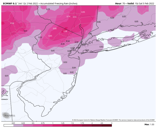
heehaw453 wrote:NWS. I think generally <= 1/4" on the ice, but this is too light IMO especially NEPA/NW NJ.
Here is Upton's take on ice and back end snow as well. Seems reasonable to me.
Last edited by sroc4 on Wed Feb 02, 2022 12:36 pm; edited 1 time in total
_________________
"In weather and in life, there's no winning and losing; there's only winning and learning."
WINTER 2012/2013 TOTALS 43.65"WINTER 2017/2018 TOTALS 62.85" WINTER 2022/2023 TOTALS 4.9"
WINTER 2013/2014 TOTALS 64.85"WINTER 2018/2019 TOTALS 14.25" WINTER 2023/2024 TOTALS 13.1"
WINTER 2014/2015 TOTALS 71.20"WINTER 2019/2020 TOTALS 6.35"
WINTER 2015/2016 TOTALS 35.00"WINTER 2020/2021 TOTALS 37.75"
WINTER 2016/2017 TOTALS 42.25"WINTER 2021/2022 TOTALS 31.65"

sroc4- Admin

- Posts : 8331
Reputation : 301
Join date : 2013-01-07
Location : Wading River, LI
Re: Monitoring February 4th
![]() by Frank_Wx Wed Feb 02, 2022 12:35 pm
by Frank_Wx Wed Feb 02, 2022 12:35 pm
SoulSingMG wrote:Upton's first stab at Friday's ice accretion:
This is a good call at this juncture, and if models trend icier they can adjust tomorrow.
_________________
_______________________________________________________________________________________________________
CLICK HERE to view NJ Strong Snowstorm Classifications

Frank_Wx- Godzilla Seeker
- Posts : 21305
Reputation : 328
Join date : 2013-01-05
Age : 31
Location : Jersey City, NJ -

SoulSingMG and JT33 like this post
Re: Monitoring February 4th
![]() by sroc4 Wed Feb 02, 2022 12:37 pm
by sroc4 Wed Feb 02, 2022 12:37 pm
_________________
"In weather and in life, there's no winning and losing; there's only winning and learning."
WINTER 2012/2013 TOTALS 43.65"WINTER 2017/2018 TOTALS 62.85" WINTER 2022/2023 TOTALS 4.9"
WINTER 2013/2014 TOTALS 64.85"WINTER 2018/2019 TOTALS 14.25" WINTER 2023/2024 TOTALS 13.1"
WINTER 2014/2015 TOTALS 71.20"WINTER 2019/2020 TOTALS 6.35"
WINTER 2015/2016 TOTALS 35.00"WINTER 2020/2021 TOTALS 37.75"
WINTER 2016/2017 TOTALS 42.25"WINTER 2021/2022 TOTALS 31.65"
sroc4- Admin
- Posts : 8331
Reputation : 301
Join date : 2013-01-07
Location : Wading River, LI
SoulSingMG likes this post
Re: Monitoring February 4th
![]() by Frank_Wx Wed Feb 02, 2022 12:41 pm
by Frank_Wx Wed Feb 02, 2022 12:41 pm
MattyICE wrote:GFS really continues to be an outlier here and most other guidance has shifted away from a widespread icing issue for the majority of the board, IMO. Usual caveats apply - keep an eye on additional trends, better to be safe than sorry, etc…I would potentially believe the GFS more if all that cold air (all valid points by mugs, RB) was actually ENTRENCHED and trying hard not to budge - but that’s not the case here at all. It’s rather the opposite - the cold air is rushing in to scour out relatively mild air. It’s doing it in a pretty progressive pattern and it’s we have to rely on limited precipitation being left AFTER the front passes. I do think most places can see a brief flip to frozen precipitation but much later in the day than the GFS shows and with minimal impacts for most SE of 287. NONE of this is to say that we should let our guards down!
Agree with this. Some models show temps reaching 50 degrees Thursday night. It’s going to be awfully tough to cool the columns down while there’s still precip left to fall
Here’s the Canadian products at 12z ice amounts


_________________
_______________________________________________________________________________________________________
CLICK HERE to view NJ Strong Snowstorm Classifications
Frank_Wx- Godzilla Seeker
- Posts : 21305
Reputation : 328
Join date : 2013-01-05
Age : 31
Location : Jersey City, NJ -
MattyICE likes this post
Re: Monitoring February 4th
![]() by freezerburn Wed Feb 02, 2022 12:46 pm
by freezerburn Wed Feb 02, 2022 12:46 pm
freezerburn- Posts : 16
Reputation : 1
Join date : 2014-01-01
Location : Toms River
amugs likes this post
Re: Monitoring February 4th
![]() by heehaw453 Wed Feb 02, 2022 12:56 pm
by heehaw453 Wed Feb 02, 2022 12:56 pm
MattyICE wrote:GFS really continues to be an outlier here and most other guidance has shifted away from a widespread icing issue for the majority of the board, IMO. Usual caveats apply - keep an eye on additional trends, better to be safe than sorry, etc…I would potentially believe the GFS more if all that cold air (all valid points by mugs, RB) was actually ENTRENCHED and trying hard not to budge - but that’s not the case here at all. It’s rather the opposite - the cold air is rushing in to scour out relatively mild air. It’s doing it in a pretty progressive pattern and it’s we have to rely on limited precipitation being left AFTER the front passes. I do think most places can see a brief flip to frozen precipitation but much later in the day than the GFS shows and with minimal impacts for most SE of 287. NONE of this is to say that we should let our guards down!
Your last sentence says it all. You can get very surprised by low level cold push with strong H oozing down. Seen that song before where it's under modeled just how strong the push is. Mid-levels will be tougher to move out, but not surface. 1/4" can go all the way down to EPA IMO with no problem.
heehaw453- Advanced Forecaster
- Posts : 3906
Reputation : 86
Join date : 2014-01-20
Location : Bedminster Township, PA Elevation 600' ASL
Re: Monitoring February 4th
![]() by jimv45 Wed Feb 02, 2022 1:18 pm
by jimv45 Wed Feb 02, 2022 1:18 pm
jimv45- Senior Enthusiast
- Posts : 1168
Reputation : 36
Join date : 2013-09-20
Location : Hopewell jct.
Re: Monitoring February 4th
![]() by amugs Wed Feb 02, 2022 1:24 pm
by amugs Wed Feb 02, 2022 1:24 pm

Point - we have seen arctic HP that have taken temps from 50* and sun in the afternoon/late evening to 29* and a snowstorm. Once you get below 30* it becomes a situation for ice accretion to gain traction (no pun). 25* IF it happens is a different animal - possibilities.
NYC not a major ice event yes but NNJ is going to be slip sliding away.
Do not forget Wednesday January 5th what happened. Pre-melt treatment is worthless with rain to ice since it will get washed away. Salt crews need to salt and retreat and retreat again to keep roads from freezing up.
Time will tell but one thing is for sure - that HP is a beast and after the storm we may have a semi-flash freeze as the precip winds down on the backside.
12Z EURO has little to no ice now.
Rb thoughts??
_________________
Mugs
AKA:King: Snow Weenie
Self Proclaimed
WINTER 2014-15 : 55.12" +.02 for 6 coatings (avg. 35")
WINTER 2015-16 Total - 29.8" (Avg 35")
WINTER 2016-17 : 39.5" so far

amugs- Advanced Forecaster - Mod
- Posts : 15093
Reputation : 213
Join date : 2013-01-07
Age : 54
Location : Hillsdale,NJ
Re: Monitoring February 4th
![]() by hyde345 Wed Feb 02, 2022 1:34 pm
by hyde345 Wed Feb 02, 2022 1:34 pm
[/quote
Jim, you are going to see some ZR and lots of sleet I think, then turning to snow midday Friday. NWS Albany has me getting .20 of ZR, 1-2 inches of sleet then some light snow.

hyde345- Pro Enthusiast

- Posts : 1082
Reputation : 48
Join date : 2013-01-08
Location : Hyde Park, NY
Re: Monitoring February 4th
![]() by jimv45 Wed Feb 02, 2022 1:38 pm
by jimv45 Wed Feb 02, 2022 1:38 pm
jimv45- Senior Enthusiast
- Posts : 1168
Reputation : 36
Join date : 2013-09-20
Location : Hopewell jct.
Re: Monitoring February 4th
![]() by RJB8525 Wed Feb 02, 2022 1:50 pm
by RJB8525 Wed Feb 02, 2022 1:50 pm


RJB8525- Senior Enthusiast
- Posts : 1994
Reputation : 28
Join date : 2013-02-06
Age : 38
Location : Hackettstown, NJ
Re: Monitoring February 4th
![]() by mikeypizano Wed Feb 02, 2022 2:00 pm
by mikeypizano Wed Feb 02, 2022 2:00 pm
RJB8525 wrote:gonna get the snowblower out for this one
Better be a big one!

mikeypizano- Pro Enthusiast
- Posts : 1118
Reputation : 66
Join date : 2017-01-05
Age : 35
Location : Wilkes-Barre/Scranton, PA
RJB8525 likes this post
Re: Monitoring February 4th
![]() by docstox12 Wed Feb 02, 2022 2:30 pm
by docstox12 Wed Feb 02, 2022 2:30 pm
RJB8525 wrote:gonna get the snowblower out for this one
More likely the leaf blower.

docstox12- Wx Statistician Guru

- Posts : 8507
Reputation : 222
Join date : 2013-01-07
Age : 73
Location : Monroe NY
Re: Monitoring February 4th
![]() by heehaw453 Wed Feb 02, 2022 2:30 pm
by heehaw453 Wed Feb 02, 2022 2:30 pm
mikeypizano wrote:RJB8525 wrote:gonna get the snowblower out for this one
Better be a big one!
It's been pretty rough w.r.t. snowfall this winter Lehigh Valley, Poconos, right up to Scranton. Hopefully something breaks sooner than later.
heehaw453- Advanced Forecaster
- Posts : 3906
Reputation : 86
Join date : 2014-01-20
Location : Bedminster Township, PA Elevation 600' ASL
Re: Monitoring February 4th
![]() by heehaw453 Wed Feb 02, 2022 2:31 pm
by heehaw453 Wed Feb 02, 2022 2:31 pm
docstox12 wrote:RJB8525 wrote:gonna get the snowblower out for this one
More likely the leaf blower.
Yeah almost comical map. Just say < 1" and call it a day.
heehaw453- Advanced Forecaster
- Posts : 3906
Reputation : 86
Join date : 2014-01-20
Location : Bedminster Township, PA Elevation 600' ASL

hyde345- Pro Enthusiast
- Posts : 1082
Reputation : 48
Join date : 2013-01-08
Location : Hyde Park, NY
RJB8525 likes this post
RJB8525- Senior Enthusiast
- Posts : 1994
Reputation : 28
Join date : 2013-02-06
Age : 38
Location : Hackettstown, NJ
Re: Monitoring February 4th
![]() by jmanley32 Wed Feb 02, 2022 2:45 pm
by jmanley32 Wed Feb 02, 2022 2:45 pm

jmanley32- Senior Enthusiast
- Posts : 20517
Reputation : 108
Join date : 2013-12-12
Age : 42
Location : Yonkers, NY
Re: Monitoring February 4th
![]() by jmanley32 Wed Feb 02, 2022 2:48 pm
by jmanley32 Wed Feb 02, 2022 2:48 pm
my sis in syracuse looks to do nicely, my niece and nephew will be having fun.RJB8525 wrote:hyde345 wrote:
now that's a snow map
jmanley32- Senior Enthusiast
- Posts : 20517
Reputation : 108
Join date : 2013-12-12
Age : 42
Location : Yonkers, NY
heehaw453 likes this post
Re: Monitoring February 4th
![]() by Frank_Wx Wed Feb 02, 2022 2:59 pm
by Frank_Wx Wed Feb 02, 2022 2:59 pm
_________________
_______________________________________________________________________________________________________
CLICK HERE to view NJ Strong Snowstorm Classifications
Frank_Wx- Godzilla Seeker
- Posts : 21305
Reputation : 328
Join date : 2013-01-05
Age : 31
Location : Jersey City, NJ -
Re: Monitoring February 4th
![]() by jimv45 Wed Feb 02, 2022 3:07 pm
by jimv45 Wed Feb 02, 2022 3:07 pm
jimv45- Senior Enthusiast
- Posts : 1168
Reputation : 36
Join date : 2013-09-20
Location : Hopewell jct.
Page 6 of 13 • 1, 2, 3 ... 5, 6, 7 ... 11, 12, 13 ![]()
|
|
|