
 Search
Tropics
Page 4 of 19 •  1, 2, 3, 4, 5 ... 11 ... 19
 ![]()
Re: Tropics
![]() by sroc4 Mon Aug 29, 2022 3:58 pm
by sroc4 Mon Aug 29, 2022 3:58 pm
jmanley32 wrote:These two systems have been pretty consistent on developing. The system clesest to the EC is the 70% chance the NHC has right now. That one has me interested for a EC threat around 7-14th time frame anywhere from FL north, no way to speculate though 18z did a pretty nutty loop back to carolinas then up EC with a deluge that we do not need, we need a soft steady rain for about 15 days lol.amugs wrote:18z GFS back to its old ways??? Crazy scenario.

The one that comes out of the Caribbean; into the GOM was only modled on the GFS. Unfort the GFS has been and usually is clueless regarding tropics, relative to the euro at least. There has been significant shear forecast on the euro which inhibited it from developing. GFS had much weaker shear; hence the development. The Euro clearly won out on that one. Its leading the way on the other one as well.
sroc4- Admin

- Posts : 8331
Join date : 2013-01-07
Re: Tropics
![]() by dkodgis Tue Aug 30, 2022 10:19 am
by dkodgis Tue Aug 30, 2022 10:19 am
dkodgis- Senior Enthusiast

- Posts : 2505
Join date : 2013-12-29
billg315 likes this post
Re: Tropics
![]() by billg315 Tue Aug 30, 2022 3:51 pm
by billg315 Tue Aug 30, 2022 3:51 pm

billg315- Advanced Forecaster - Mod

- Posts : 4469
Reputation : 185
Join date : 2015-01-24
Age : 50
Location : Flemington, NJ
Re: Tropics
![]() by sroc4 Wed Aug 31, 2022 7:46 am
by sroc4 Wed Aug 31, 2022 7:46 am

The red area was an area to keep a general eye on but its quickly becoming an Atlantic ocean concern only. GFS once again is developing this area much faster and much stronger; whereas, the euro keeps it much weaker for longer. In fact the euro now barely gets it beyond a Trop depression or weak trop storm at worst before it recurves well OTS. The Euro leads the way on this one IMO yet again. Two main things to look at.
First: Wind shear environment. Euro forecasts indicate stronger vertical wind shear in the mid levels out ahead, inhibiting rapid development.
Second: Dry air infiltration. You can see that by the time the wave reaches the Longitude of about the Lesser Antilles, which is about 3.5days from now (+/-) the GFS is much more saturated; therefore, developed vs the euro which has the dry air environment wrapping into the circulation which ultimately inhibits its development.


We shall see what happens with this area over the next 2-4days but up through now the Euro has def had a much better handle on both the observed shear environment and the mid level relative humidity. The result has been a better short range forecast to the development, or lack thereof, of these last few waves traversing the ITCZ.
_________________
"In weather and in life, there's no winning and losing; there's only winning and learning."
WINTER 2012/2013 TOTALS 43.65"WINTER 2017/2018 TOTALS 62.85" WINTER 2022/2023 TOTALS 4.9"
WINTER 2013/2014 TOTALS 64.85"WINTER 2018/2019 TOTALS 14.25" WINTER 2023/2024 TOTALS 13.1"
WINTER 2014/2015 TOTALS 71.20"WINTER 2019/2020 TOTALS 6.35"
WINTER 2015/2016 TOTALS 35.00"WINTER 2020/2021 TOTALS 37.75"
WINTER 2016/2017 TOTALS 42.25"WINTER 2021/2022 TOTALS 31.65"

sroc4- Admin
- Posts : 8331
Reputation : 301
Join date : 2013-01-07
Location : Wading River, LI
weatherwatchermom likes this post
Re: Tropics
![]() by weatherwatchermom Wed Aug 31, 2022 2:58 pm
by weatherwatchermom Wed Aug 31, 2022 2:58 pm
not hoping for anything other than a little rain...lol it is a boring hot summer..so heres to hoping we have a busy cold winter!! thanks for the update!sroc4 wrote:Going to have to wait awhile longer it appears if one is hoping for a tropical system to approach the area.
The red area was an area to keep a general eye on but its quickly becoming an Atlantic ocean concern only. GFS once again is developing this area much faster and much stronger; whereas, the euro keeps it much weaker for longer. In fact the euro now barely gets it beyond a Trop depression or weak trop storm at worst before it recurves well OTS. The Euro leads the way on this one IMO yet again. Two main things to look at.
First: Wind shear environment. Euro forecasts indicate stronger vertical wind shear in the mid levels out ahead, inhibiting rapid development.
Second: Dry air infiltration. You can see that by the time the wave reaches the Longitude of about the Lesser Antilles, which is about 3.5days from now (+/-) the GFS is much more saturated; therefore, developed vs the euro which has the dry air environment wrapping into the circulation which ultimately inhibits its development.
We shall see what happens with this area over the next 2-4days but up through now the Euro has def had a much better handle on both the observed shear environment and the mid level relative humidity. The result has been a better short range forecast to the development, or lack thereof, of these last few waves traversing the ITCZ.
Last edited by weatherwatchermom on Wed Aug 31, 2022 8:59 pm; edited 1 time in total

weatherwatchermom- Senior Enthusiast
- Posts : 3750
Reputation : 77
Join date : 2014-11-25
Age : 60
Location : Hazlet Township, NJ
Re: Tropics
![]() by sroc4 Wed Aug 31, 2022 4:48 pm
by sroc4 Wed Aug 31, 2022 4:48 pm
weatherwatchermom wrote:not hoping for anything other than a little rain...lol it is a boring hot summer..so hears to hoping we have a busy cold winter!! thanks for the update!sroc4 wrote:Going to have to wait awhile longer it appears if one is hoping for a tropical system to approach the area.
The red area was an area to keep a general eye on but its quickly becoming an Atlantic ocean concern only. GFS once again is developing this area much faster and much stronger; whereas, the euro keeps it much weaker for longer. In fact the euro now barely gets it beyond a Trop depression or weak trop storm at worst before it recurves well OTS. The Euro leads the way on this one IMO yet again. Two main things to look at.
First: Wind shear environment. Euro forecasts indicate stronger vertical wind shear in the mid levels out ahead, inhibiting rapid development.
Second: Dry air infiltration. You can see that by the time the wave reaches the Longitude of about the Lesser Antilles, which is about 3.5days from now (+/-) the GFS is much more saturated; therefore, developed vs the euro which has the dry air environment wrapping into the circulation which ultimately inhibits its development.
We shall see what happens with this area over the next 2-4days but up through now the Euro has def had a much better handle on both the observed shear environment and the mid level relative humidity. The result has been a better short range forecast to the development, or lack thereof, of these last few waves traversing the ITCZ.
I’m just dying to track something interesting. Frontal passages that fizzle out over my back yard just isn’t cutting it anymore. Lol. Hear is definitely to a cold white winter.
_________________
"In weather and in life, there's no winning and losing; there's only winning and learning."
WINTER 2012/2013 TOTALS 43.65"WINTER 2017/2018 TOTALS 62.85" WINTER 2022/2023 TOTALS 4.9"
WINTER 2013/2014 TOTALS 64.85"WINTER 2018/2019 TOTALS 14.25" WINTER 2023/2024 TOTALS 13.1"
WINTER 2014/2015 TOTALS 71.20"WINTER 2019/2020 TOTALS 6.35"
WINTER 2015/2016 TOTALS 35.00"WINTER 2020/2021 TOTALS 37.75"
WINTER 2016/2017 TOTALS 42.25"WINTER 2021/2022 TOTALS 31.65"
sroc4- Admin
- Posts : 8331
Reputation : 301
Join date : 2013-01-07
Location : Wading River, LI
weatherwatchermom likes this post
Re: Tropics
![]() by amugs Wed Aug 31, 2022 8:50 pm
by amugs Wed Aug 31, 2022 8:50 pm
There's signs for a strong suppressed Kelvin wave to pas the Atlantic-Africa during early September, which will destructively interfere with the Climatological Peak in the Atlantic Hurricane Season. This wave will act to suppress convection o/the tropical Atlantic-Africa. https://t.co/J5QnEFnFsG pic.twitter.com/DdD5ETAEZ1
— Mike Ventrice (@MJVentrice) August 30, 2022
_________________
Mugs
AKA:King: Snow Weenie
Self Proclaimed
WINTER 2014-15 : 55.12" +.02 for 6 coatings (avg. 35")
WINTER 2015-16 Total - 29.8" (Avg 35")
WINTER 2016-17 : 39.5" so far

amugs- Advanced Forecaster - Mod
- Posts : 15093
Reputation : 213
Join date : 2013-01-07
Age : 54
Location : Hillsdale,NJ
Re: Tropics
![]() by sroc4 Fri Sep 02, 2022 11:54 am
by sroc4 Fri Sep 02, 2022 11:54 am
The red area just east of the Lesser Antilles still has me interested. The GFS conts to develop that area, IMHO, way too fast which results in a recurve. However, if it remains a weak wave, which I believe it will, as the euro insists on there is a good chance it makes it much further west riding just north of the Greater Antilles. Whats happens from there is what is causing my ears to perk up a bit. There will be a trough approaching the EC between day 2-4. The GFS has a deeper trough that exits the coast and aids in picking up the developed system and recurving it way OTS. However the Euro leaves a piece behind over the Ohio valley region which develops into an upper level low cutoff from the mean flow. The result of this is a weaker trough exiting the EC that is further N so it does not have the same influence(doesnt draw it N sooner) on the trop system in question. Combined with the fact that it is also still a weaker system. The cutoff ULL aids in enhancing the western Atlantic ridge(WAR) to build back in over the top of the Trop system which further stears our trop wave or weak system further west towards the SE coast. From there it gets drawn upo the coast and begins the recurve. These details are still fuzzy so Ill leave it at that.
Bottom line a fork is in the road over the next 2-4days. Does this system develop rapidly like the GFS suggest and turn harmlessly OTS or does it remain weaker and the euro suggests, and continues along a WNW-NWward trajectory in which case we will have to start watching it more closely? If the latter occurs there will still be many forks in the road but it will make it at least a tad more interesting.
WE TRACK!!!

_________________
"In weather and in life, there's no winning and losing; there's only winning and learning."
WINTER 2012/2013 TOTALS 43.65"WINTER 2017/2018 TOTALS 62.85" WINTER 2022/2023 TOTALS 4.9"
WINTER 2013/2014 TOTALS 64.85"WINTER 2018/2019 TOTALS 14.25" WINTER 2023/2024 TOTALS 13.1"
WINTER 2014/2015 TOTALS 71.20"WINTER 2019/2020 TOTALS 6.35"
WINTER 2015/2016 TOTALS 35.00"WINTER 2020/2021 TOTALS 37.75"
WINTER 2016/2017 TOTALS 42.25"WINTER 2021/2022 TOTALS 31.65"
sroc4- Admin
- Posts : 8331
Reputation : 301
Join date : 2013-01-07
Location : Wading River, LI
kalleg and weatherwatchermom like this post
Re: Tropics
![]() by sroc4 Sun Sep 04, 2022 9:43 pm
by sroc4 Sun Sep 04, 2022 9:43 pm
_________________
"In weather and in life, there's no winning and losing; there's only winning and learning."
WINTER 2012/2013 TOTALS 43.65"WINTER 2017/2018 TOTALS 62.85" WINTER 2022/2023 TOTALS 4.9"
WINTER 2013/2014 TOTALS 64.85"WINTER 2018/2019 TOTALS 14.25" WINTER 2023/2024 TOTALS 13.1"
WINTER 2014/2015 TOTALS 71.20"WINTER 2019/2020 TOTALS 6.35"
WINTER 2015/2016 TOTALS 35.00"WINTER 2020/2021 TOTALS 37.75"
WINTER 2016/2017 TOTALS 42.25"WINTER 2021/2022 TOTALS 31.65"
sroc4- Admin
- Posts : 8331
Reputation : 301
Join date : 2013-01-07
Location : Wading River, LI
weatherwatchermom likes this post
Re: Tropics
![]() by amugs Mon Sep 05, 2022 8:46 pm
by amugs Mon Sep 05, 2022 8:46 pm
sroc4 wrote:Earl is still something to be watched along the EC. There is still a change it misses the connection to the recurve and a hook back to the west is possible. By no means is this imminent but something to monitor. That is all for now.
Earl is going to do something very interesting as he looks to get caught under thr HP over Newfoundland and he gets pushed west toward the EC and then rides up into Maine. Very interesting.
JB said Friday don't write him off, he misses the westerlies then its gets interesting.
_________________
Mugs
AKA:King: Snow Weenie
Self Proclaimed
WINTER 2014-15 : 55.12" +.02 for 6 coatings (avg. 35")
WINTER 2015-16 Total - 29.8" (Avg 35")
WINTER 2016-17 : 39.5" so far
amugs- Advanced Forecaster - Mod
- Posts : 15093
Reputation : 213
Join date : 2013-01-07
Age : 54
Location : Hillsdale,NJ
Re: Tropics
![]() by amugs Mon Sep 12, 2022 9:38 pm
by amugs Mon Sep 12, 2022 9:38 pm

_________________
Mugs
AKA:King: Snow Weenie
Self Proclaimed
WINTER 2014-15 : 55.12" +.02 for 6 coatings (avg. 35")
WINTER 2015-16 Total - 29.8" (Avg 35")
WINTER 2016-17 : 39.5" so far
amugs- Advanced Forecaster - Mod
- Posts : 15093
Reputation : 213
Join date : 2013-01-07
Age : 54
Location : Hillsdale,NJ
Re: Tropics
![]() by jmanley32 Mon Sep 12, 2022 11:24 pm
by jmanley32 Mon Sep 12, 2022 11:24 pm

jmanley32- Senior Enthusiast
- Posts : 20517
Reputation : 108
Join date : 2013-12-12
Age : 42
Location : Yonkers, NY
Zhukov1945 likes this post
Re: Tropics
![]() by jmanley32 Wed Sep 14, 2022 6:00 pm
by jmanley32 Wed Sep 14, 2022 6:00 pm

jmanley32- Senior Enthusiast
- Posts : 20517
Reputation : 108
Join date : 2013-12-12
Age : 42
Location : Yonkers, NY
Zhukov1945 likes this post
Re: Tropics
![]() by jmanley32 Wed Sep 14, 2022 6:07 pm
by jmanley32 Wed Sep 14, 2022 6:07 pm
probably more like 24th or later with TD7.amugs wrote:Eyes on Central Atlantic for development. Sept 16 to 24th timeframe for US issues, hit are what I am reading at this time.
jmanley32- Senior Enthusiast
- Posts : 20517
Reputation : 108
Join date : 2013-12-12
Age : 42
Location : Yonkers, NY
Re: Tropics
![]() by jmanley32 Wed Sep 14, 2022 10:23 pm
by jmanley32 Wed Sep 14, 2022 10:23 pm
jmanley32- Senior Enthusiast
- Posts : 20517
Reputation : 108
Join date : 2013-12-12
Age : 42
Location : Yonkers, NY
Re: Tropics
![]() by sroc4 Thu Sep 15, 2022 7:34 am
by sroc4 Thu Sep 15, 2022 7:34 am
jmanley32 wrote:We have TS Fiona folks, 50mph TS, could be a interesting one to track. Def going to get closer to the US mainland.
I’m desperate to track something too. Lol. While there is nothing wrong with tracking Fiona through the lesser and greater Antilles it won’t get remotely interesting to track regarding the EC until Monday Tuesday at the earliest. Even then it will still be about 1000miles out.
We Track
_________________
"In weather and in life, there's no winning and losing; there's only winning and learning."
WINTER 2012/2013 TOTALS 43.65"WINTER 2017/2018 TOTALS 62.85" WINTER 2022/2023 TOTALS 4.9"
WINTER 2013/2014 TOTALS 64.85"WINTER 2018/2019 TOTALS 14.25" WINTER 2023/2024 TOTALS 13.1"
WINTER 2014/2015 TOTALS 71.20"WINTER 2019/2020 TOTALS 6.35"
WINTER 2015/2016 TOTALS 35.00"WINTER 2020/2021 TOTALS 37.75"
WINTER 2016/2017 TOTALS 42.25"WINTER 2021/2022 TOTALS 31.65"
sroc4- Admin
- Posts : 8331
Reputation : 301
Join date : 2013-01-07
Location : Wading River, LI
amugs and SoulSingMG like this post
Re: Tropics
![]() by amugs Thu Sep 15, 2022 8:45 am
by amugs Thu Sep 15, 2022 8:45 am
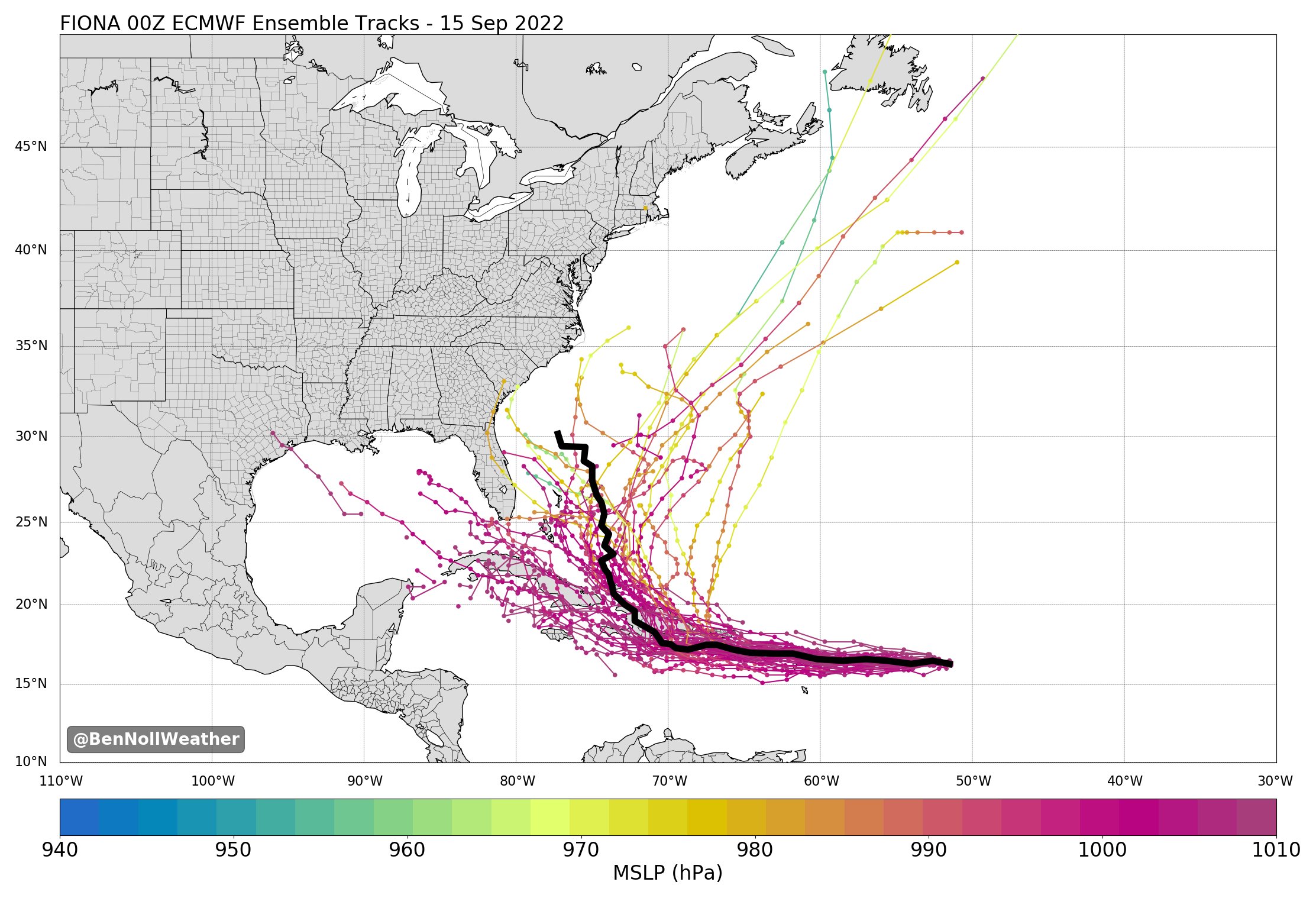
EURO tracks Fiona. Ions of time for this
_________________
Mugs
AKA:King: Snow Weenie
Self Proclaimed
WINTER 2014-15 : 55.12" +.02 for 6 coatings (avg. 35")
WINTER 2015-16 Total - 29.8" (Avg 35")
WINTER 2016-17 : 39.5" so far
amugs- Advanced Forecaster - Mod
- Posts : 15093
Reputation : 213
Join date : 2013-01-07
Age : 54
Location : Hillsdale,NJ
Re: Tropics
![]() by sroc4 Thu Sep 15, 2022 12:37 pm
by sroc4 Thu Sep 15, 2022 12:37 pm
https://www.tropicaltidbits.com/sat/satlooper.php?region=07L&product=vis

_________________
"In weather and in life, there's no winning and losing; there's only winning and learning."
WINTER 2012/2013 TOTALS 43.65"WINTER 2017/2018 TOTALS 62.85" WINTER 2022/2023 TOTALS 4.9"
WINTER 2013/2014 TOTALS 64.85"WINTER 2018/2019 TOTALS 14.25" WINTER 2023/2024 TOTALS 13.1"
WINTER 2014/2015 TOTALS 71.20"WINTER 2019/2020 TOTALS 6.35"
WINTER 2015/2016 TOTALS 35.00"WINTER 2020/2021 TOTALS 37.75"
WINTER 2016/2017 TOTALS 42.25"WINTER 2021/2022 TOTALS 31.65"
sroc4- Admin
- Posts : 8331
Reputation : 301
Join date : 2013-01-07
Location : Wading River, LI
SoulSingMG likes this post
Re: Tropics
![]() by dkodgis Thu Sep 15, 2022 12:46 pm
by dkodgis Thu Sep 15, 2022 12:46 pm

dkodgis- Senior Enthusiast
- Posts : 2505
Reputation : 98
Join date : 2013-12-29
Re: Tropics
![]() by sroc4 Thu Sep 15, 2022 2:24 pm
by sroc4 Thu Sep 15, 2022 2:24 pm
dkodgis wrote:And will there be a dip in the jet stream to allow it to head north. Lots of variable will make it interesting to track
There will be a couple of troughs swinging through and off the EC as we go through the next 3-5days. These will start to weaken the western flank of the WAR (western Atlantic ridge) to Fiona's north a nd beging to shunt the center of it a tad further E. This is wjhats currently steering her. A trough headed towards the EC will create a weakness as we head into the middle of next week. How strong and deep the trough is, and how strong and how far N or S Fiona is etc will determine when and where exactly she turns north.
There will most likely be one of two scenarios. Either Fiona is sitting further N and/or more organized and results in being tugged and recurved harmlessly OTS by the trough that swings through towards the middle to latter half of next week. OR its further S, and west, and/or weaker and less organized and is initially is tugged N through the weakness created by the same trough, but misses the connection as the trough lifts out. That would/could result in a ridge building back in over the top of Fiona just off the NE coast of the CONUS, and a turn her back towards the west, towards coast ahead of the next trough could ensue. That would get things really interesting.
Of course this somewhat of an over simplification, but these are a few of the major keys to the track evolution. There are multiple other details that need to be looked at. ie: two upper level lows and how they influence things. One that develops to the NE of Fiona over the next several days way out in the central Atlantic, as well as a second, and probably more influential, that is showing up in the modeling over Fla to Fiona's NW over the next several days. There will be a crossroads over the next 3-5days for sure. The modeling on the timing of the WAR, the mean Trough, and where and how strong Fiona is will begin to dial in then. Its still a ways out, but at least its something.
We Track
_________________
"In weather and in life, there's no winning and losing; there's only winning and learning."
WINTER 2012/2013 TOTALS 43.65"WINTER 2017/2018 TOTALS 62.85" WINTER 2022/2023 TOTALS 4.9"
WINTER 2013/2014 TOTALS 64.85"WINTER 2018/2019 TOTALS 14.25" WINTER 2023/2024 TOTALS 13.1"
WINTER 2014/2015 TOTALS 71.20"WINTER 2019/2020 TOTALS 6.35"
WINTER 2015/2016 TOTALS 35.00"WINTER 2020/2021 TOTALS 37.75"
WINTER 2016/2017 TOTALS 42.25"WINTER 2021/2022 TOTALS 31.65"
sroc4- Admin
- Posts : 8331
Reputation : 301
Join date : 2013-01-07
Location : Wading River, LI
Re: Tropics
![]() by rb924119 Thu Sep 15, 2022 10:58 pm
by rb924119 Thu Sep 15, 2022 10:58 pm
Tonight’s 18z GFS Op at 384:

Loading pattern for Sandy:

Paging Jman lmaooooo
rb924119- Meteorologist

- Posts : 6890
Reputation : 194
Join date : 2013-02-06
Age : 32
Location : Greentown, Pa
rb924119- Meteorologist
- Posts : 6890
Reputation : 194
Join date : 2013-02-06
Age : 32
Location : Greentown, Pa
amugs likes this post
Re: Tropics
![]() by dkodgis Sat Sep 17, 2022 12:45 pm
by dkodgis Sat Sep 17, 2022 12:45 pm
dkodgis- Senior Enthusiast
- Posts : 2505
Reputation : 98
Join date : 2013-12-29
Re: Tropics
![]() by jmanley32 Sat Sep 17, 2022 4:32 pm
by jmanley32 Sat Sep 17, 2022 4:32 pm
jmanley32- Senior Enthusiast
- Posts : 20517
Reputation : 108
Join date : 2013-12-12
Age : 42
Location : Yonkers, NY
Re: Tropics
![]() by jmanley32 Sat Sep 17, 2022 4:33 pm
by jmanley32 Sat Sep 17, 2022 4:33 pm
Looks like it will spare the US but as I noted above Bermuda may be in big trouble.dkodgis wrote:Fiona is looking to go further off our coast and not be a significant weather feature?
jmanley32- Senior Enthusiast
- Posts : 20517
Reputation : 108
Join date : 2013-12-12
Age : 42
Location : Yonkers, NY
Re: Tropics
![]() by sroc4 Sat Sep 17, 2022 7:40 pm
by sroc4 Sat Sep 17, 2022 7:40 pm
dkodgis wrote:Fiona is looking to go further off our coast and not be a significant weather feature?
Looking that way Damian. Only potential fly in the ointment would be if she gets torn apart by going right over the mountains of Hispaniola and remains weak once it’s on the northern side. There are a few euro ensembles that still show this possibility. The overall consensus does seem to involves a fairly potent trough that sucks her right up and out. No is scotia to Bermuda are still in the game as Jon pointed out.
Last edited by sroc4 on Sat Sep 17, 2022 11:24 pm; edited 1 time in total
_________________
"In weather and in life, there's no winning and losing; there's only winning and learning."
WINTER 2012/2013 TOTALS 43.65"WINTER 2017/2018 TOTALS 62.85" WINTER 2022/2023 TOTALS 4.9"
WINTER 2013/2014 TOTALS 64.85"WINTER 2018/2019 TOTALS 14.25" WINTER 2023/2024 TOTALS 13.1"
WINTER 2014/2015 TOTALS 71.20"WINTER 2019/2020 TOTALS 6.35"
WINTER 2015/2016 TOTALS 35.00"WINTER 2020/2021 TOTALS 37.75"
WINTER 2016/2017 TOTALS 42.25"WINTER 2021/2022 TOTALS 31.65"
sroc4- Admin
- Posts : 8331
Reputation : 301
Join date : 2013-01-07
Location : Wading River, LI
Re: Tropics
![]() by sroc4 Sat Sep 17, 2022 7:41 pm
by sroc4 Sat Sep 17, 2022 7:41 pm
_________________
"In weather and in life, there's no winning and losing; there's only winning and learning."
WINTER 2012/2013 TOTALS 43.65"WINTER 2017/2018 TOTALS 62.85" WINTER 2022/2023 TOTALS 4.9"
WINTER 2013/2014 TOTALS 64.85"WINTER 2018/2019 TOTALS 14.25" WINTER 2023/2024 TOTALS 13.1"
WINTER 2014/2015 TOTALS 71.20"WINTER 2019/2020 TOTALS 6.35"
WINTER 2015/2016 TOTALS 35.00"WINTER 2020/2021 TOTALS 37.75"
WINTER 2016/2017 TOTALS 42.25"WINTER 2021/2022 TOTALS 31.65"
sroc4- Admin
- Posts : 8331
Reputation : 301
Join date : 2013-01-07
Location : Wading River, LI
Page 4 of 19 • 1, 2, 3, 4, 5 ... 11 ... 19 ![]()
|
|
|