
 Search
Long Range Thread 25.0
Page 28 of 40 •  1 ... 15 ... 27, 28, 29 ... 34 ... 40
 ![]()
Re: Long Range Thread 25.0
![]() by amugs Tue Jan 17, 2023 11:46 am
by amugs Tue Jan 17, 2023 11:46 am

amugs- Advanced Forecaster - Mod

- Posts : 15093
Join date : 2013-01-07
Re: Long Range Thread 25.0
![]() by amugs Tue Jan 17, 2023 11:56 am
by amugs Tue Jan 17, 2023 11:56 am
Now admit it. You thought winter was over!
Guess again. The classic January Thaw configuration is collapsing after a 2.5 week stay in North America. This change is achieved by a shift in the volatile storm sequence from the Pacific Ocean eastward into the lower 48 states, with concurrent ridge formation in the Gulf of Alaska and over the northern Atlantic Ocean. The flat split flow aloft will be replaced by a deep bowl shaped trough at 500MB allowing an Arctic regime over northers Canada to be displaced (quickly, I might add....) southward to the right of the Continental Divide. Each disturbance in the series will yank the colder air southward, with only Florida escaping the winter chill.
The first impulse in the group may set up snow chances in the Missouri Valley and Upper Midwest, with a risk of strong/severe thunderstorms from parts of Texas and Oklahoma into the Mid-South and Ohio Valley. The drop in temperature behind this first system will be marginal. But the next two pieces of energy will produce a rude shock/surprise.

Early next week a combination of a polar and subtropical jet stream shortwaves will strengthen and reform in the western Gulf of Mexico. Following the ECMWF model scenario, this new area of low pressure pulls colder air all the way down to Mexico and begins a trajectory through the Deep South before turning up along the Eastern Seaboard. The rightward shift in this path forecast in recent model runs is irksome. But for now I see this as a rain and thunder event for Interstate 95 communities and a rain/ice/snow change along and 150 miles to the left of the track. That could put parts of TX/OK into the Midwest and lower Great Lakes in some frozen precipitation.
In about ten days, when most of the nation (outside of the Florida Peninsula) is in polar or Arctic air, a wave in northern Mexico will begin a deepening phase as it heads eastward below the Gulf Coast. All who want to see a credible ice and snow threat in the Deep South and Eastern Seaboard need to watch this feature.
amugs- Advanced Forecaster - Mod
- Posts : 15093
Join date : 2013-01-07
Re: Long Range Thread 25.0
![]() by heehaw453 Tue Jan 17, 2023 12:01 pm
by heehaw453 Tue Jan 17, 2023 12:01 pm
Yeah. It's going to depend on good Confluence to the north to dampen heights to the north. Otherwise this pull too far north to flood mid-levels and we rain. But we're used to that by now...amugs wrote:This is a good spot of many of the LP's here as circled in red for Sunday into Mondays storm
heehaw453- Advanced Forecaster

- Posts : 3906
Reputation : 86
Join date : 2014-01-20
Location : Bedminster Township, PA Elevation 600' ASL
Re: Long Range Thread 25.0
![]() by sroc4 Tue Jan 17, 2023 12:29 pm
by sroc4 Tue Jan 17, 2023 12:29 pm
heehaw453 wrote:Yeah. It's going to depend on good Confluence to the north to dampen heights to the north. Otherwise this pull too far north to flood mid-levels and we rain. But we're used to that by now...amugs wrote:This is a good spot of many of the LP's here as circled in red for Sunday into Mondays storm
What's been the trend all year....underestimated southern systems that trend stronger in the near term that are able to overcome any resistance to the north raising heights and flooding those mid levels. Eventually that will change, just not sure this is the storm to do it.
_________________
"In weather and in life, there's no winning and losing; there's only winning and learning."
WINTER 2012/2013 TOTALS 43.65"WINTER 2017/2018 TOTALS 62.85" WINTER 2022/2023 TOTALS 4.9"
WINTER 2013/2014 TOTALS 64.85"WINTER 2018/2019 TOTALS 14.25" WINTER 2023/2024 TOTALS 13.1"
WINTER 2014/2015 TOTALS 71.20"WINTER 2019/2020 TOTALS 6.35"
WINTER 2015/2016 TOTALS 35.00"WINTER 2020/2021 TOTALS 37.75"
WINTER 2016/2017 TOTALS 42.25"WINTER 2021/2022 TOTALS 31.65"

sroc4- Admin

- Posts : 8331
Reputation : 301
Join date : 2013-01-07
Location : Wading River, LI
heehaw453 likes this post
Re: Long Range Thread 25.0
![]() by CPcantmeasuresnow Tue Jan 17, 2023 12:37 pm
by CPcantmeasuresnow Tue Jan 17, 2023 12:37 pm
amugs wrote:From LC
Now admit it. You thought winter was over!
Guess again. The classic January Thaw configuration is collapsing after a 2.5 week stay in North America. This change is achieved by a shift in the volatile storm sequence from the Pacific Ocean eastward into the lower 48 states, with concurrent ridge formation in the Gulf of Alaska and over the northern Atlantic Ocean. The flat split flow aloft will be replaced by a deep bowl shaped trough at 500MB allowing an Arctic regime over northers Canada to be displaced (quickly, I might add....) southward to the right of the Continental Divide. Each disturbance in the series will yank the colder air southward, with only Florida escaping the winter chill.
The first impulse in the group may set up snow chances in the Missouri Valley and Upper Midwest, with a risk of strong/severe thunderstorms from parts of Texas and Oklahoma into the Mid-South and Ohio Valley. The drop in temperature behind this first system will be marginal. But the next two pieces of energy will produce a rude shock/surprise.
Early next week a combination of a polar and subtropical jet stream shortwaves will strengthen and reform in the western Gulf of Mexico. Following the ECMWF model scenario, this new area of low pressure pulls colder air all the way down to Mexico and begins a trajectory through the Deep South before turning up along the Eastern Seaboard. The rightward shift in this path forecast in recent model runs is irksome. But for now I see this as a rain and thunder event for Interstate 95 communities and a rain/ice/snow change along and 150 miles to the left of the track. That could put parts of TX/OK into the Midwest and lower Great Lakes in some frozen precipitation.
In about ten days, when most of the nation (outside of the Florida Peninsula) is in polar or Arctic air, a wave in northern Mexico will begin a deepening phase as it heads eastward below the Gulf Coast. All who want to see a credible ice and snow threat in the Deep South and Eastern Seaboard need to watch this feature.
We thought Winter was over? For something to be over it needs a beginning.

CPcantmeasuresnow- Wx Statistician Guru

- Posts : 7274
Reputation : 230
Join date : 2013-01-07
Age : 103
Location : Eastern Orange County, NY
Frank_Wx, jmanley32, heehaw453 and phil155 like this post
Re: Long Range Thread 25.0
![]() by heehaw453 Tue Jan 17, 2023 12:58 pm
by heehaw453 Tue Jan 17, 2023 12:58 pm
Going to have to agree with that until more evidence suggests otherwise. Depending on confluence to do the job probably not going to happen as per past experiences. I think though LHV, NEPA, NW NJ could be in line for some minor accumulations.sroc4 wrote:heehaw453 wrote:Yeah. It's going to depend on good Confluence to the north to dampen heights to the north. Otherwise this pull too far north to flood mid-levels and we rain. But we're used to that by now...amugs wrote:This is a good spot of many of the LP's here as circled in red for Sunday into Mondays storm
What's been the trend all year....underestimated southern systems that trend stronger in the near term that are able to overcome any resistance to the north raising heights and flooding those mid levels. Eventually that will change, just not sure this is the storm to do it.
heehaw453- Advanced Forecaster
- Posts : 3906
Reputation : 86
Join date : 2014-01-20
Location : Bedminster Township, PA Elevation 600' ASL
CPcantmeasuresnow likes this post
Re: Long Range Thread 25.0
![]() by amugs Tue Jan 17, 2023 1:00 pm
by amugs Tue Jan 17, 2023 1:00 pm
_________________
Mugs
AKA:King: Snow Weenie
Self Proclaimed
WINTER 2014-15 : 55.12" +.02 for 6 coatings (avg. 35")
WINTER 2015-16 Total - 29.8" (Avg 35")
WINTER 2016-17 : 39.5" so far

amugs- Advanced Forecaster - Mod
- Posts : 15093
Reputation : 213
Join date : 2013-01-07
Age : 54
Location : Hillsdale,NJ
phil155 likes this post
Re: Long Range Thread 25.0
![]() by heehaw453 Tue Jan 17, 2023 2:34 pm
by heehaw453 Tue Jan 17, 2023 2:34 pm

heehaw453- Advanced Forecaster
- Posts : 3906
Reputation : 86
Join date : 2014-01-20
Location : Bedminster Township, PA Elevation 600' ASL
Re: Long Range Thread 25.0
![]() by hyde345 Tue Jan 17, 2023 7:15 pm
by hyde345 Tue Jan 17, 2023 7:15 pm
CPcantmeasuresnow wrote:amugs wrote:From LC
Now admit it. You thought winter was over!
Guess again. The classic January Thaw configuration is collapsing after a 2.5 week stay in North America. This change is achieved by a shift in the volatile storm sequence from the Pacific Ocean eastward into the lower 48 states, with concurrent ridge formation in the Gulf of Alaska and over the northern Atlantic Ocean. The flat split flow aloft will be replaced by a deep bowl shaped trough at 500MB allowing an Arctic regime over northers Canada to be displaced (quickly, I might add....) southward to the right of the Continental Divide. Each disturbance in the series will yank the colder air southward, with only Florida escaping the winter chill.
The first impulse in the group may set up snow chances in the Missouri Valley and Upper Midwest, with a risk of strong/severe thunderstorms from parts of Texas and Oklahoma into the Mid-South and Ohio Valley. The drop in temperature behind this first system will be marginal. But the next two pieces of energy will produce a rude shock/surprise.
Early next week a combination of a polar and subtropical jet stream shortwaves will strengthen and reform in the western Gulf of Mexico. Following the ECMWF model scenario, this new area of low pressure pulls colder air all the way down to Mexico and begins a trajectory through the Deep South before turning up along the Eastern Seaboard. The rightward shift in this path forecast in recent model runs is irksome. But for now I see this as a rain and thunder event for Interstate 95 communities and a rain/ice/snow change along and 150 miles to the left of the track. That could put parts of TX/OK into the Midwest and lower Great Lakes in some frozen precipitation.
In about ten days, when most of the nation (outside of the Florida Peninsula) is in polar or Arctic air, a wave in northern Mexico will begin a deepening phase as it heads eastward below the Gulf Coast. All who want to see a credible ice and snow threat in the Deep South and Eastern Seaboard need to watch this feature.
We thought Winter was over? For something to be over it needs a beginning.
At least we had some snow and had snow cover for a few weeks. There are many who have recvd nada.

hyde345- Pro Enthusiast

- Posts : 1082
Reputation : 48
Join date : 2013-01-08
Location : Hyde Park, NY
Re: Long Range Thread 25.0
![]() by CPcantmeasuresnow Tue Jan 17, 2023 8:13 pm
by CPcantmeasuresnow Tue Jan 17, 2023 8:13 pm
hyde345 wrote:CPcantmeasuresnow wrote:amugs wrote:From LC
Now admit it. You thought winter was over!
Guess again. The classic January Thaw configuration is collapsing after a 2.5 week stay in North America. This change is achieved by a shift in the volatile storm sequence from the Pacific Ocean eastward into the lower 48 states, with concurrent ridge formation in the Gulf of Alaska and over the northern Atlantic Ocean. The flat split flow aloft will be replaced by a deep bowl shaped trough at 500MB allowing an Arctic regime over northers Canada to be displaced (quickly, I might add....) southward to the right of the Continental Divide. Each disturbance in the series will yank the colder air southward, with only Florida escaping the winter chill.
The first impulse in the group may set up snow chances in the Missouri Valley and Upper Midwest, with a risk of strong/severe thunderstorms from parts of Texas and Oklahoma into the Mid-South and Ohio Valley. The drop in temperature behind this first system will be marginal. But the next two pieces of energy will produce a rude shock/surprise.
Early next week a combination of a polar and subtropical jet stream shortwaves will strengthen and reform in the western Gulf of Mexico. Following the ECMWF model scenario, this new area of low pressure pulls colder air all the way down to Mexico and begins a trajectory through the Deep South before turning up along the Eastern Seaboard. The rightward shift in this path forecast in recent model runs is irksome. But for now I see this as a rain and thunder event for Interstate 95 communities and a rain/ice/snow change along and 150 miles to the left of the track. That could put parts of TX/OK into the Midwest and lower Great Lakes in some frozen precipitation.
In about ten days, when most of the nation (outside of the Florida Peninsula) is in polar or Arctic air, a wave in northern Mexico will begin a deepening phase as it heads eastward below the Gulf Coast. All who want to see a credible ice and snow threat in the Deep South and Eastern Seaboard need to watch this feature.
We thought Winter was over? For something to be over it needs a beginning.
At least we had some snow and had snow cover for a few weeks. There are many who have recvd nada.
True Hyde but what I’ve had so far which totals 4.8 inches is the normal total by the first week in December.
CPcantmeasuresnow- Wx Statistician Guru
- Posts : 7274
Reputation : 230
Join date : 2013-01-07
Age : 103
Location : Eastern Orange County, NY
Re: Long Range Thread 25.0
![]() by heehaw453 Tue Jan 17, 2023 9:48 pm
by heehaw453 Tue Jan 17, 2023 9:48 pm
heehaw453- Advanced Forecaster
- Posts : 3906
Reputation : 86
Join date : 2014-01-20
Location : Bedminster Township, PA Elevation 600' ASL
CPcantmeasuresnow likes this post
Re: Long Range Thread 25.0
![]() by hyde345 Tue Jan 17, 2023 10:01 pm
by hyde345 Tue Jan 17, 2023 10:01 pm
CPcantmeasuresnow wrote:hyde345 wrote:CPcantmeasuresnow wrote:amugs wrote:From LC
Now admit it. You thought winter was over!
Guess again. The classic January Thaw configuration is collapsing after a 2.5 week stay in North America. This change is achieved by a shift in the volatile storm sequence from the Pacific Ocean eastward into the lower 48 states, with concurrent ridge formation in the Gulf of Alaska and over the northern Atlantic Ocean. The flat split flow aloft will be replaced by a deep bowl shaped trough at 500MB allowing an Arctic regime over northers Canada to be displaced (quickly, I might add....) southward to the right of the Continental Divide. Each disturbance in the series will yank the colder air southward, with only Florida escaping the winter chill.
The first impulse in the group may set up snow chances in the Missouri Valley and Upper Midwest, with a risk of strong/severe thunderstorms from parts of Texas and Oklahoma into the Mid-South and Ohio Valley. The drop in temperature behind this first system will be marginal. But the next two pieces of energy will produce a rude shock/surprise.
Early next week a combination of a polar and subtropical jet stream shortwaves will strengthen and reform in the western Gulf of Mexico. Following the ECMWF model scenario, this new area of low pressure pulls colder air all the way down to Mexico and begins a trajectory through the Deep South before turning up along the Eastern Seaboard. The rightward shift in this path forecast in recent model runs is irksome. But for now I see this as a rain and thunder event for Interstate 95 communities and a rain/ice/snow change along and 150 miles to the left of the track. That could put parts of TX/OK into the Midwest and lower Great Lakes in some frozen precipitation.
In about ten days, when most of the nation (outside of the Florida Peninsula) is in polar or Arctic air, a wave in northern Mexico will begin a deepening phase as it heads eastward below the Gulf Coast. All who want to see a credible ice and snow threat in the Deep South and Eastern Seaboard need to watch this feature.
We thought Winter was over? For something to be over it needs a beginning.
At least we had some snow and had snow cover for a few weeks. There are many who have recvd nada.
True Hyde but what I’ve had so far which totals 4.8 inches is the normal total by the first week in December.
Oh I know. I only have 5 so far. Horrible winter but at least we had something. It's still hard to believe Central Park has zero so far and could break the all time record.
hyde345- Pro Enthusiast
- Posts : 1082
Reputation : 48
Join date : 2013-01-08
Location : Hyde Park, NY
weatherwatchermom likes this post

dkodgis- Senior Enthusiast

- Posts : 2505
Reputation : 98
Join date : 2013-12-29
Re: Long Range Thread 25.0
![]() by heehaw453 Tue Jan 17, 2023 10:07 pm
by heehaw453 Tue Jan 17, 2023 10:07 pm

heehaw453- Advanced Forecaster
- Posts : 3906
Reputation : 86
Join date : 2014-01-20
Location : Bedminster Township, PA Elevation 600' ASL
Re: Long Range Thread 25.0
![]() by weatherwatchermom Tue Jan 17, 2023 10:11 pm
by weatherwatchermom Tue Jan 17, 2023 10:11 pm
hyde345 wrote:CPcantmeasuresnow wrote:hyde345 wrote:CPcantmeasuresnow wrote:amugs wrote:From LC
Now admit it. You thought winter was over!
Guess again. The classic January Thaw configuration is collapsing after a 2.5 week stay in North America. This change is achieved by a shift in the volatile storm sequence from the Pacific Ocean eastward into the lower 48 states, with concurrent ridge formation in the Gulf of Alaska and over the northern Atlantic Ocean. The flat split flow aloft will be replaced by a deep bowl shaped trough at 500MB allowing an Arctic regime over northers Canada to be displaced (quickly, I might add....) southward to the right of the Continental Divide. Each disturbance in the series will yank the colder air southward, with only Florida escaping the winter chill.
The first impulse in the group may set up snow chances in the Missouri Valley and Upper Midwest, with a risk of strong/severe thunderstorms from parts of Texas and Oklahoma into the Mid-South and Ohio Valley. The drop in temperature behind this first system will be marginal. But the next two pieces of energy will produce a rude shock/surprise.
Early next week a combination of a polar and subtropical jet stream shortwaves will strengthen and reform in the western Gulf of Mexico. Following the ECMWF model scenario, this new area of low pressure pulls colder air all the way down to Mexico and begins a trajectory through the Deep South before turning up along the Eastern Seaboard. The rightward shift in this path forecast in recent model runs is irksome. But for now I see this as a rain and thunder event for Interstate 95 communities and a rain/ice/snow change along and 150 miles to the left of the track. That could put parts of TX/OK into the Midwest and lower Great Lakes in some frozen precipitation.
In about ten days, when most of the nation (outside of the Florida Peninsula) is in polar or Arctic air, a wave in northern Mexico will begin a deepening phase as it heads eastward below the Gulf Coast. All who want to see a credible ice and snow threat in the Deep South and Eastern Seaboard need to watch this feature.
We thought Winter was over? For something to be over it needs a beginning.
At least we had some snow and had snow cover for a few weeks. There are many who have recvd nada.
True Hyde but what I’ve had so far which totals 4.8 inches is the normal total by the first week in December.
Oh I know. I only have 5 so far. Horrible winter but at least we had something. It's still hard to believe Central Park has zero so far and could break the all time record.
We had 5 flakes the other day..

weatherwatchermom- Senior Enthusiast
- Posts : 3750
Reputation : 77
Join date : 2014-11-25
Age : 60
Location : Hazlet Township, NJ
CPcantmeasuresnow and heehaw453 like this post
Re: Long Range Thread 25.0
![]() by heehaw453 Wed Jan 18, 2023 6:52 am
by heehaw453 Wed Jan 18, 2023 6:52 am
An ULL closing off over I90 works very well for VT, NH, ME but not here. So unless there are some rather large scale changes this one is finished IMO. Oh and the one behind incoming 25th ish I'm not too keen on either for snow. Just look how amped up it is.
Storm-->ridge-->storm--->ridge rinse and repeat unfortunately. Whether the TPV helps us out we see after the 25th, but for now...


heehaw453- Advanced Forecaster
- Posts : 3906
Reputation : 86
Join date : 2014-01-20
Location : Bedminster Township, PA Elevation 600' ASL
Re: Long Range Thread 25.0
![]() by sroc4 Wed Jan 18, 2023 7:02 am
by sroc4 Wed Jan 18, 2023 7:02 am
weatherwatchermom wrote:hyde345 wrote:CPcantmeasuresnow wrote:hyde345 wrote:CPcantmeasuresnow wrote:amugs wrote:From LC
Now admit it. You thought winter was over!
Guess again. The classic January Thaw configuration is collapsing after a 2.5 week stay in North America. This change is achieved by a shift in the volatile storm sequence from the Pacific Ocean eastward into the lower 48 states, with concurrent ridge formation in the Gulf of Alaska and over the northern Atlantic Ocean. The flat split flow aloft will be replaced by a deep bowl shaped trough at 500MB allowing an Arctic regime over northers Canada to be displaced (quickly, I might add....) southward to the right of the Continental Divide. Each disturbance in the series will yank the colder air southward, with only Florida escaping the winter chill.
The first impulse in the group may set up snow chances in the Missouri Valley and Upper Midwest, with a risk of strong/severe thunderstorms from parts of Texas and Oklahoma into the Mid-South and Ohio Valley. The drop in temperature behind this first system will be marginal. But the next two pieces of energy will produce a rude shock/surprise.
Early next week a combination of a polar and subtropical jet stream shortwaves will strengthen and reform in the western Gulf of Mexico. Following the ECMWF model scenario, this new area of low pressure pulls colder air all the way down to Mexico and begins a trajectory through the Deep South before turning up along the Eastern Seaboard. The rightward shift in this path forecast in recent model runs is irksome. But for now I see this as a rain and thunder event for Interstate 95 communities and a rain/ice/snow change along and 150 miles to the left of the track. That could put parts of TX/OK into the Midwest and lower Great Lakes in some frozen precipitation.
In about ten days, when most of the nation (outside of the Florida Peninsula) is in polar or Arctic air, a wave in northern Mexico will begin a deepening phase as it heads eastward below the Gulf Coast. All who want to see a credible ice and snow threat in the Deep South and Eastern Seaboard need to watch this feature.
We thought Winter was over? For something to be over it needs a beginning.
At least we had some snow and had snow cover for a few weeks. There are many who have recvd nada.
True Hyde but what I’ve had so far which totals 4.8 inches is the normal total by the first week in December.
Oh I know. I only have 5 so far. Horrible winter but at least we had something. It's still hard to believe Central Park has zero so far and could break the all time record.
We had 5 flakes the other day..you have to laugh or go mad
Or laugh because you have gone mad.
_________________
"In weather and in life, there's no winning and losing; there's only winning and learning."
WINTER 2012/2013 TOTALS 43.65"WINTER 2017/2018 TOTALS 62.85" WINTER 2022/2023 TOTALS 4.9"
WINTER 2013/2014 TOTALS 64.85"WINTER 2018/2019 TOTALS 14.25" WINTER 2023/2024 TOTALS 13.1"
WINTER 2014/2015 TOTALS 71.20"WINTER 2019/2020 TOTALS 6.35"
WINTER 2015/2016 TOTALS 35.00"WINTER 2020/2021 TOTALS 37.75"
WINTER 2016/2017 TOTALS 42.25"WINTER 2021/2022 TOTALS 31.65"
sroc4- Admin
- Posts : 8331
Reputation : 301
Join date : 2013-01-07
Location : Wading River, LI
weatherwatchermom likes this post
Re: Long Range Thread 25.0
![]() by amugs Wed Jan 18, 2023 10:08 am
by amugs Wed Jan 18, 2023 10:08 am

_________________
Mugs
AKA:King: Snow Weenie
Self Proclaimed
WINTER 2014-15 : 55.12" +.02 for 6 coatings (avg. 35")
WINTER 2015-16 Total - 29.8" (Avg 35")
WINTER 2016-17 : 39.5" so far
amugs- Advanced Forecaster - Mod
- Posts : 15093
Reputation : 213
Join date : 2013-01-07
Age : 54
Location : Hillsdale,NJ
heehaw453 likes this post
Re: Long Range Thread 25.0
![]() by heehaw453 Wed Jan 18, 2023 11:42 am
by heehaw453 Wed Jan 18, 2023 11:42 am

heehaw453- Advanced Forecaster
- Posts : 3906
Reputation : 86
Join date : 2014-01-20
Location : Bedminster Township, PA Elevation 600' ASL
CPcantmeasuresnow and SENJsnowman like this post
Re: Long Range Thread 25.0
![]() by Frank_Wx Wed Jan 18, 2023 12:41 pm
by Frank_Wx Wed Jan 18, 2023 12:41 pm
Unfortunately I'm not too optimistic about the 500mb pattern. I actually feel better about the storm signal around the 25th.
_________________
_______________________________________________________________________________________________________
CLICK HERE to view NJ Strong Snowstorm Classifications

Frank_Wx- Godzilla Seeker
- Posts : 21305
Reputation : 328
Join date : 2013-01-05
Age : 31
Location : Jersey City, NJ -

Re: Long Range Thread 25.0
![]() by heehaw453 Wed Jan 18, 2023 1:52 pm
by heehaw453 Wed Jan 18, 2023 1:52 pm

heehaw453- Advanced Forecaster
- Posts : 3906
Reputation : 86
Join date : 2014-01-20
Location : Bedminster Township, PA Elevation 600' ASL
Re: Long Range Thread 25.0
![]() by heehaw453 Wed Jan 18, 2023 2:05 pm
by heehaw453 Wed Jan 18, 2023 2:05 pm

heehaw453- Advanced Forecaster
- Posts : 3906
Reputation : 86
Join date : 2014-01-20
Location : Bedminster Township, PA Elevation 600' ASL
CPcantmeasuresnow and phil155 like this post
Re: Long Range Thread 25.0
![]() by phil155 Wed Jan 18, 2023 2:09 pm
by phil155 Wed Jan 18, 2023 2:09 pm
phil155- Pro Enthusiast
- Posts : 475
Reputation : 4
Join date : 2019-12-16
heehaw453 likes this post
Re: Long Range Thread 25.0
![]() by Frank_Wx Wed Jan 18, 2023 5:45 pm
by Frank_Wx Wed Jan 18, 2023 5:45 pm
The Monday storm could deliver white gold to areas well N&W of here, but I’m not enthused.
_________________
_______________________________________________________________________________________________________
CLICK HERE to view NJ Strong Snowstorm Classifications
Frank_Wx- Godzilla Seeker
- Posts : 21305
Reputation : 328
Join date : 2013-01-05
Age : 31
Location : Jersey City, NJ -
CPcantmeasuresnow, heehaw453 and phil155 like this post
Re: Long Range Thread 25.0
![]() by heehaw453 Wed Jan 18, 2023 6:56 pm
by heehaw453 Wed Jan 18, 2023 6:56 pm

heehaw453- Advanced Forecaster
- Posts : 3906
Reputation : 86
Join date : 2014-01-20
Location : Bedminster Township, PA Elevation 600' ASL
Re: Long Range Thread 25.0
![]() by amugs Wed Jan 18, 2023 7:47 pm
by amugs Wed Jan 18, 2023 7:47 pm
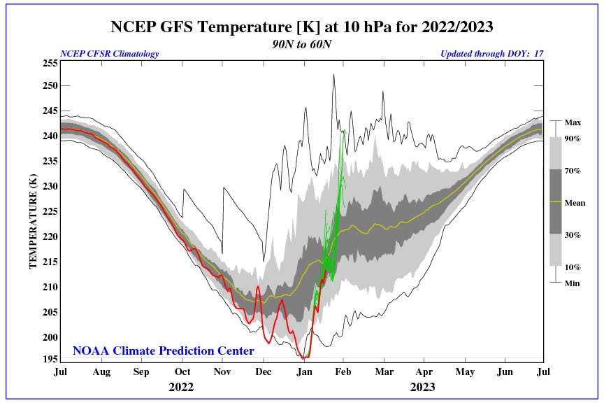
For the #PolarVortex (PV) the hits keep coming with the best yet to come from upwelling wave energy from the troposphere. What does this mean for the PV & the impact on our weather? It's serious when I dust off the six-step snow model. The blog now public: https://t.co/Gg8N2KIjJS pic.twitter.com/KBya32hZrn
— Judah Cohen (@judah47) January 18, 2023
This is along that Frank and I have been posting here for a while now. Dr. Lee and Butler are on this as well.
Cohen said, "I am not predicting a split just ....yet"!! That would be interesting if it happens for midish for late Feb.
Time will tell
_________________
Mugs
AKA:King: Snow Weenie
Self Proclaimed
WINTER 2014-15 : 55.12" +.02 for 6 coatings (avg. 35")
WINTER 2015-16 Total - 29.8" (Avg 35")
WINTER 2016-17 : 39.5" so far
amugs- Advanced Forecaster - Mod
- Posts : 15093
Reputation : 213
Join date : 2013-01-07
Age : 54
Location : Hillsdale,NJ
Re: Long Range Thread 25.0
![]() by CPcantmeasuresnow Wed Jan 18, 2023 9:23 pm
by CPcantmeasuresnow Wed Jan 18, 2023 9:23 pm
heehaw453 wrote:Monday's system the Icon believes in a snow lover's dream. Has it ever been right?
It’s been such a horrible non Winter so far maybe we need something supernatural like the Icon being a correct outlier several days in advance to get us out of this funk.
CPcantmeasuresnow- Wx Statistician Guru
- Posts : 7274
Reputation : 230
Join date : 2013-01-07
Age : 103
Location : Eastern Orange County, NY
Page 28 of 40 • 1 ... 15 ... 27, 28, 29 ... 34 ... 40 ![]()
|
|
|