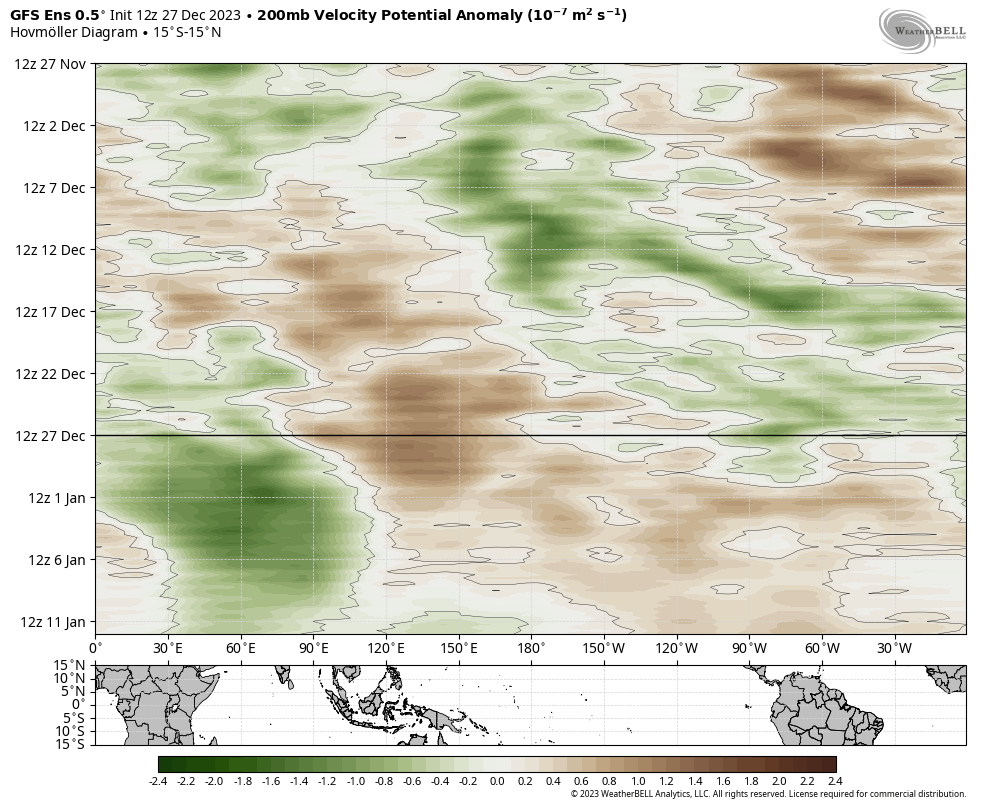
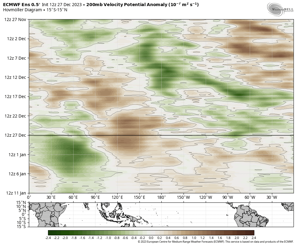
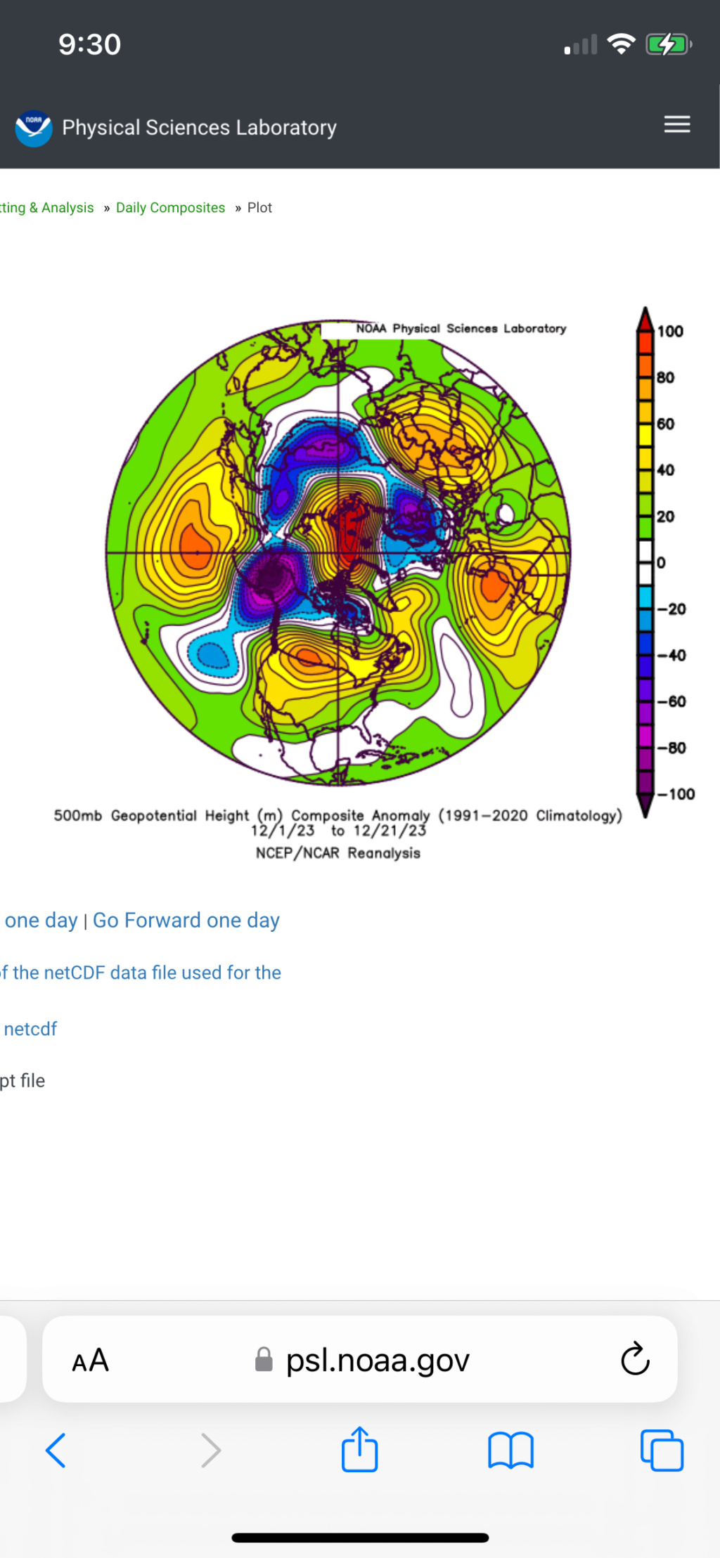
Long Range Thread 27.0
Page 20 of 40 •  1 ... 11 ... 19, 20, 21 ... 30 ... 40
 Re: Long Range Thread 27.0
Koroptim- Posts : 29
Join date : 2013-01-16
sroc4, docstox12, HectorO, kalleg, dkodgis, heehaw453 and weatherwatchermom like this post
 Re: Long Range Thread 27.0
heehaw453- Advanced Forecaster

- Posts : 3906
Join date : 2014-01-20
 Re: Long Range Thread 27.0
What are you going to do when the Polar Vortex runs wild on you? pic.twitter.com/Naypu7bf9w
— Ryan Maue (@RyanMaue) December 26, 2023
_________________
Mugs
AKA:King: Snow Weenie
Self Proclaimed
WINTER 2014-15 : 55.12" +.02 for 6 coatings (avg. 35")
WINTER 2015-16 Total - 29.8" (Avg 35")
WINTER 2016-17 : 39.5" so far

amugs- Advanced Forecaster - Mod

- Posts : 15093
Reputation : 213
Join date : 2013-01-07
Age : 54
Location : Hillsdale,NJ
kalleg and dkodgis like this post
 Re: Long Range Thread 27.0

dkodgis- Senior Enthusiast

- Posts : 2505
Reputation : 98
Join date : 2013-12-29
docstox12 and Irish like this post
 Re: Long Range Thread 27.0
dkodgis wrote:Central América won’t be happy

Irish- Pro Enthusiast

- Posts : 788
Reputation : 19
Join date : 2019-01-16
Age : 45
Location : Old Bridge, NJ
kalleg likes this post
 Re: Long Range Thread 27.0
Can't think of a better way to start a new year than with a #SSW.
— Dr. Amy H Butler (@DrAHButler) December 26, 2023GEOS forecast model on board with some massive stratospheric heat fluxes in the next 10 days. pic.twitter.com/3u56S8Mrzi
_________________
Mugs
AKA:King: Snow Weenie
Self Proclaimed
WINTER 2014-15 : 55.12" +.02 for 6 coatings (avg. 35")
WINTER 2015-16 Total - 29.8" (Avg 35")
WINTER 2016-17 : 39.5" so far

amugs- Advanced Forecaster - Mod

- Posts : 15093
Reputation : 213
Join date : 2013-01-07
Age : 54
Location : Hillsdale,NJ
 Re: Long Range Thread 27.0
_________________
Mugs
AKA:King: Snow Weenie
Self Proclaimed
WINTER 2014-15 : 55.12" +.02 for 6 coatings (avg. 35")
WINTER 2015-16 Total - 29.8" (Avg 35")
WINTER 2016-17 : 39.5" so far

amugs- Advanced Forecaster - Mod

- Posts : 15093
Reputation : 213
Join date : 2013-01-07
Age : 54
Location : Hillsdale,NJ
docstox12, kalleg, essexcountypete, heehaw453 and SENJsnowman like this post
 Re: Long Range Thread 27.0
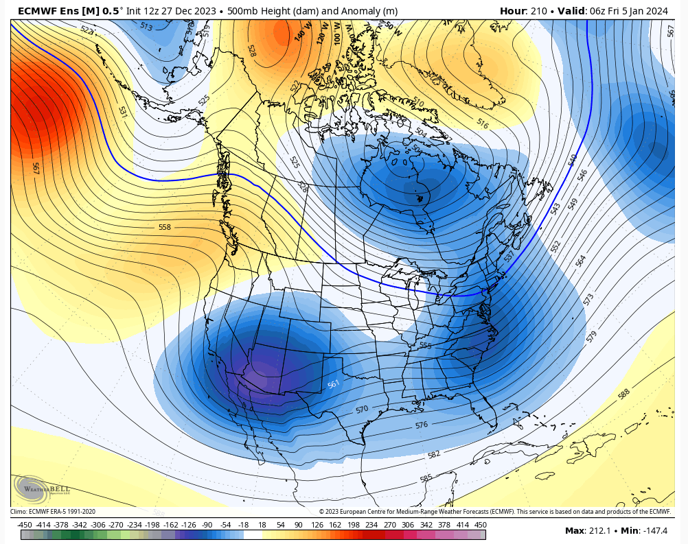
FWIW the GEFS has been leading the way with that NAO change.
heehaw453- Advanced Forecaster

- Posts : 3906
Reputation : 86
Join date : 2014-01-20
Location : Bedminster Township, PA Elevation 600' ASL
 Re: Long Range Thread 27.0
The way it used to work in these parts is favorable NAM state drastically increased the odds of snow given nothing hostile in the PAC. That's essentially what this setup is.

heehaw453- Advanced Forecaster

- Posts : 3906
Reputation : 86
Join date : 2014-01-20
Location : Bedminster Township, PA Elevation 600' ASL
sroc4 likes this post
 Re: Long Range Thread 27.0
SENJsnowman- Senior Enthusiast

- Posts : 1186
Reputation : 61
Join date : 2017-01-06
Age : 51
Location : Bayville, NJ
sroc4 and heehaw453 like this post
 Re: Long Range Thread 27.0
SENJsnowman wrote:The updates seem to be getting consistently more suited for winter weather. Now, steady as she goes…hold course.
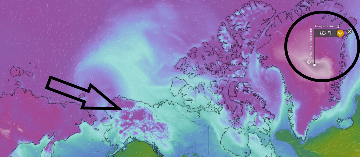
As the EPO opens up coupled with the +PNA the colder air is leaking into AK and Canada. That will take several days to work its way to east coast. The NAO going negative too will help flush the milder air out of the east coast. That's the theory anyway. Also I hear a lot of there's no cold air on our side of the globe. Not sure that is entirely accurate.
If Central Park has another January this year with no measurable snowfall I'll hang it up.
heehaw453- Advanced Forecaster

- Posts : 3906
Reputation : 86
Join date : 2014-01-20
Location : Bedminster Township, PA Elevation 600' ASL
kalleg, dkodgis and phil155 like this post
 Re: Long Range Thread 27.0
deadrabbit79- Posts : 176
Reputation : 6
Join date : 2013-01-25
Location : Hartsdale, New York
phil155 likes this post
 Re: Long Range Thread 27.0
deadrabbit79 wrote:Anyone on here concerned about the ncoming rain tonight? Local mets playing up another 1-2 inches with some spots getting up to 3 inches? Are we looking at major rain and flooding again? I’m tired of this
I think the flooding risk with this event would be very much localized to the harder hit areas of the last storm. Could be wrong but that is what I am thinking based on the idea it looks like a good soaking rain but on it’s own not overwhelming
phil155- Pro Enthusiast

- Posts : 475
Reputation : 4
Join date : 2019-12-16
deadrabbit79, heehaw453 and SENJsnowman like this post
 Re: Long Range Thread 27.0


heehaw453- Advanced Forecaster

- Posts : 3906
Reputation : 86
Join date : 2014-01-20
Location : Bedminster Township, PA Elevation 600' ASL
 Re: Long Range Thread 27.0
_________________
Mugs
AKA:King: Snow Weenie
Self Proclaimed
WINTER 2014-15 : 55.12" +.02 for 6 coatings (avg. 35")
WINTER 2015-16 Total - 29.8" (Avg 35")
WINTER 2016-17 : 39.5" so far

amugs- Advanced Forecaster - Mod

- Posts : 15093
Reputation : 213
Join date : 2013-01-07
Age : 54
Location : Hillsdale,NJ
 Re: Long Range Thread 27.0
_________________
Mugs
AKA:King: Snow Weenie
Self Proclaimed
WINTER 2014-15 : 55.12" +.02 for 6 coatings (avg. 35")
WINTER 2015-16 Total - 29.8" (Avg 35")
WINTER 2016-17 : 39.5" so far

amugs- Advanced Forecaster - Mod

- Posts : 15093
Reputation : 213
Join date : 2013-01-07
Age : 54
Location : Hillsdale,NJ
 Re: Long Range Thread 27.0
Frank_Wx wrote:sroc4 wrote: by sroc4 Mon Dec 11, 2023 7:36 am
You guys beat me to it. Just a few short days ago we were setting up for potential storm around Xmas. While the storm is still possible it he ability to tap into cold air is starting to look unlikely. If you look at the stratosphere actually the warming is currently forecast to kick the Strat PV on the wrong side of the northern hemisphere. Not looking too good
There’s a couple of storms out there with the right pieces we need. But the biggest piece is missing…COLD AIR!
The northern jet is working remotely out of Canada
So first thing Im going to show is the MJO. We have been in phase 1 for the last few days and will remain for a few more followed by 2; then 3. Beyond lets simply keep open. Under most days an MJO with this amplitude; in these phases we are 100% talking snow.
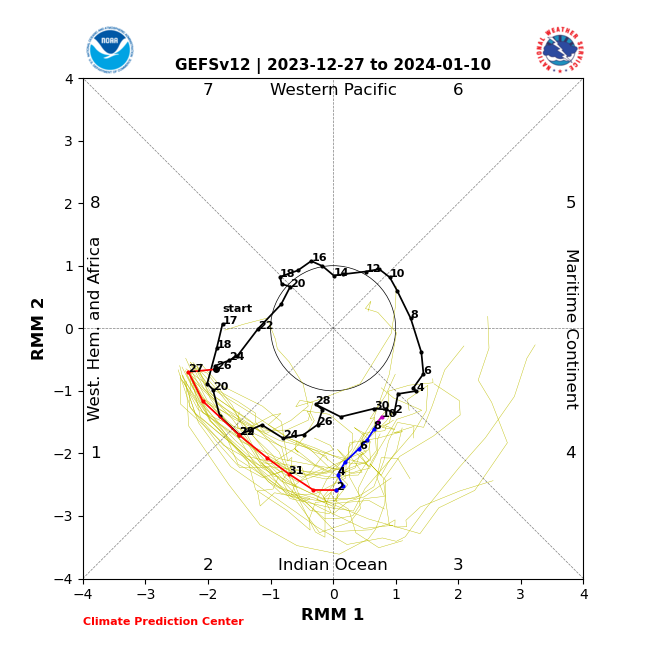
So what gives?? Well refer back to the quote from above. This was an exchange between me and Frank from Dec 11th where I mention looking at the warming taking place to the stratosphere was forecast to kick the strat off the pole but on the wrong side of the hemisphere. For some reason I abandoned that and became more focused on the MJO. But it really seems like the strat has been the dominant force, as we have been in a cold phase of the MJO, and yet the cold air no where to be found.
Take a look for yourself. Heehaw with all due respect my friend there is NO cold air in North America. If you wish to split a few hairs by showing Greenland and Alaska ok, but all of the CONUS, and most of Canada has been completely closed off from anything remotely resembling a cold air source. As you can see in the first image below(500mb) there is a huge cutoff low over the central plains. It has been pumping warm tropical air out ahead into the area. Now beneath it it is generating its own somewhat cooler air, but to its west is all Pacific and subtropical. The Pacific and polar jets are north of the Hudson Bay in Canada. All the cold air is locked up over Eastern Siberia and Alaska. Again the ULL over the central CONUS is generating its own cold air, but a true cold air source for any s/w to tap into as it hits the coast has been non existent.

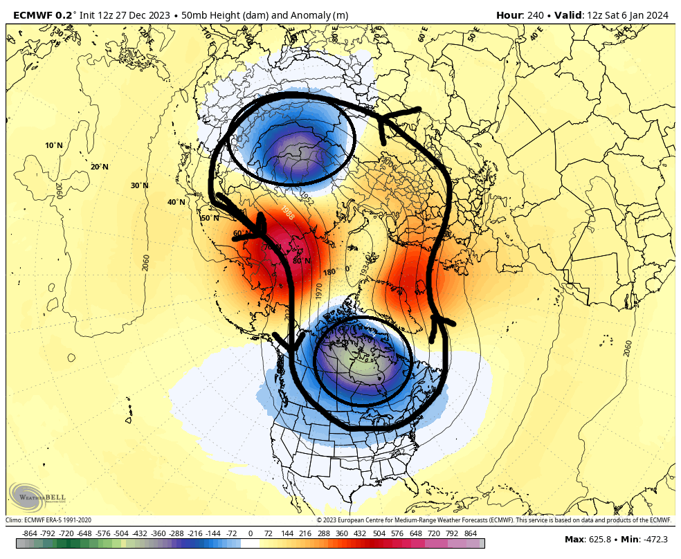
Why is the 500mb map look like this you ask? Because of the strat PV. Look at its orientation at both 10 and 50mb, (30mb is the same orientation); then look how it directly translates to where the lowest heights currently live on the image above. Again, its on the wrong side of the NHemi.


The end of the Euro run has the SPV look like this(see image below). And to one degree or another the EPS, GFS, and GEFS all have a similar look with some subtle variations. It will help bring the cold air into the CONUS if true. BUT its in the 10+day range so who knows how it all plays out. Over the past couple of seasons the amazing looking LR seems to have a way of not being quite so amazing as we get in closer. Now I will remain cautiously optimistic moving forward regarding both the 10+ day Strat PV forecast, but also the time in between. The MJO will exert a force on the atmosphere as it conts in phase 1, 2, and 3 which are all cold phases, but the MJO cold phases wont be fully realized because of the current resistance in the form of a poorly positioned Strat PV, but it will be shifting, so lets see.
_________________
"In weather and in life, there's no winning and losing; there's only winning and learning."
WINTER 2012/2013 TOTALS 43.65"WINTER 2017/2018 TOTALS 62.85" WINTER 2022/2023 TOTALS 4.9"
WINTER 2013/2014 TOTALS 64.85"WINTER 2018/2019 TOTALS 14.25" WINTER 2023/2024 TOTALS 13.1"
WINTER 2014/2015 TOTALS 71.20"WINTER 2019/2020 TOTALS 6.35"
WINTER 2015/2016 TOTALS 35.00"WINTER 2020/2021 TOTALS 37.75"
WINTER 2016/2017 TOTALS 42.25"WINTER 2021/2022 TOTALS 31.65"

sroc4- Admin

- Posts : 8331
Reputation : 301
Join date : 2013-01-07
Location : Wading River, LI
dkodgis likes this post
 Re: Long Range Thread 27.0
deadrabbit79 wrote:Anyone on here concerned about the ncoming rain tonight? Local mets playing up another 1-2 inches with some spots getting up to 3 inches? Are we looking at major rain and flooding again? I’m tired of this
I just came in from driving through Ohio and PA and it was a monsoon the whole entire ride. We beat it out finally when I hit NJ but it's baaaack.

HectorO- Pro Enthusiast

- Posts : 959
Reputation : 27
Join date : 2013-01-11
CPcantmeasuresnow and dkodgis like this post
 Re: Long Range Thread 27.0
sroc4 wrote:Frank_Wx wrote:sroc4 wrote: by sroc4 Mon Dec 11, 2023 7:36 am
You guys beat me to it. Just a few short days ago we were setting up for potential storm around Xmas. While the storm is still possible it he ability to tap into cold air is starting to look unlikely. If you look at the stratosphere actually the warming is currently forecast to kick the Strat PV on the wrong side of the northern hemisphere. Not looking too good
There’s a couple of storms out there with the right pieces we need. But the biggest piece is missing…COLD AIR!
The northern jet is working remotely out of Canada
So first thing Im going to show is the MJO. We have been in phase 1 for the last few days and will remain for a few more followed by 2; then 3. Beyond lets simply keep open. Under most days an MJO with this amplitude; in these phases we are 100% talking snow.
So what gives?? Well refer back to the quote from above. This was an exchange between me and Frank from Dec 11th where I mention looking at the warming taking place to the stratosphere was forecast to kick the strat off the pole but on the wrong side of the hemisphere. For some reason I abandoned that and became more focused on the MJO. But it really seems like the strat has been the dominant force, as we have been in a cold phase of the MJO, and yet the cold air no where to be found.
Take a look for yourself. Heehaw with all due respect my friend there is NO cold air in North America. If you wish to split a few hairs by showing Greenland and Alaska ok, but all of the CONUS, and most of Canada has been completely closed off from anything remotely resembling a cold air source. As you can see in the first image below(500mb) there is a huge cutoff low over the central plains. It has been pumping warm tropical air out ahead into the area. Now beneath it it is generating its own somewhat cooler air, but to its west is all Pacific and subtropical. The Pacific and polar jets are north of the Hudson Bay in Canada. All the cold air is locked up over Eastern Siberia and Alaska. Again the ULL over the central CONUS is generating its own cold air, but a true cold air source for any s/w to tap into as it hits the coast has been non existent.
Why is the 500mb map look like this you ask? Because of the strat PV. Look at its orientation at both 10 and 50mb, (30mb is the same orientation); then look how it directly translates to where the lowest heights currently live on the image above. Again, its on the wrong side of the NHemi.
The end of the Euro run has the SPV look like this(see image below). And to one degree or another the EPS, GFS, and GEFS all have a similar look with some subtle variations. It will help bring the cold air into the CONUS if true. BUT its in the 10+day range so who knows how it all plays out. Over the past couple of seasons the amazing looking LR seems to have a way of not being quite so amazing as we get in closer. Now I will remain cautiously optimistic moving forward regarding both the 10+ day Strat PV forecast, but also the time in between. The MJO will exert a force on the atmosphere as it conts in phase 1, 2, and 3 which are all cold phases, but the MJO cold phases wont be fully realized because of the current resistance in the form of a poorly positioned Strat PV, but it will be shifting, so lets see.
Good post, but I’m going to gently push back on the “negativity” regarding the Stratosphere (note my use of the quotation marks to imply a metaphoric use of the word lol) in your post, and in Frank’s write up from the other day (which was also great, I’ll add). This is a pretty classic Stratospheric warming event, and before we nitpick definitions regarding the wind reversals above 100 hPa, which is the textbook definition, you can have a Stratospheric warming event without a true wind reversal and get the same results. And, it is this second example that I’ll be referencing going forward. Now that that’s out of the way (lol), keep in mind that we BOTH agreed that the impacts of the Stratospheric warming event that commenced during the opening days of December would not be realized in the Troposphere until right around the start of the New Year because of the average lag time of such events, which is generally three to six weeks, and to me, that looks to be right on track.
The evolution of the warming event is almost prime with respect to how it should relate to the Tropospheric pattern, as it should allow pressures to rise across the northern latitudes and really work to set the blocking pattern off, and solidify the cutting underneath of the jet. How does this happen?
Think of the atmosphere as a vertical tube sealed on both ends, with a piece of cellophane acting as divider in the middle. Below the cellophane is the Troposphere (lower atmosphere where we reside and sensible weather happens), the cellophane itself is the Tropopause, or a relatively impermeable layer between the Troposphere and the Stratosphere, which is the layer above the cellophane. Now, pretend we induce warming in the top part of the tube, say, by using a hair dryer to heat it. This will serve as our Stratospheric warming event. As the air warms in the top half of the tube, what happens? It will expand, thereby pushing the cellophane (Tropopause) down toward the ground, and forcing the Troposphere (the air below the cellophane and where we live) to contract. Now, what happens to air when it contracts, or compresses? Yes, the air warms, but the pressure rises. So now, you start getting all of this high pressure to build across Canada relative to averages. With the jet (and storm track) being forced to cut underneath in response to the blocking, you reverse the net flow air from a southerly component to a northerly component, thereby allowing a net drainage of cold air into the CONUS. And you can see this on the modeling as you go from Week 1 into Week 2 and beyond. Just because the main PV lobe is over Siberia, it doesn’t mean it’s cold there. Their cold is over - they had it two weeks ago, and before that, when the warming in the Stratosphere was over their heads. But now, the PV is on top of them and they’re +15-25°C above average. You don’t necessarily have to track the Stratospheric PV’s location, but the evolution of the warming around it.
Beyond this, there are other effects on the Tropospheric flow which were already brought to light in the discussion of the 18th-20th storm, and that is the effect on the momentum budget. With all of this blocking, you’re going to see all kinds of closed lows and phasing, as the normal eastward propagation of energy is going to be slowed relative to averages. It just becomes a matter of where and when.
Lastly, we should see at least another Stratospheric warming event take place during the month of January, as we see the effects of the blocking in Troposphere put their hits from the bottom up. This is likely what the modeling is showing, in my opinion. And that will only proliferate the fun and games into February.
I will say this, though; if we don’t get snow in this pattern, I’d be shocked.
rb924119- Meteorologist

- Posts : 6890
Reputation : 194
Join date : 2013-02-06
Age : 32
Location : Greentown, Pa
heehaw453 likes this post
 Re: Long Range Thread 27.0
rb924119- Meteorologist

- Posts : 6890
Reputation : 194
Join date : 2013-02-06
Age : 32
Location : Greentown, Pa
heehaw453 likes this post
 Re: Long Range Thread 27.0
I spoke 7 weeks ago about the slow start to eastern CA snow fall and in December became increasingly concerned to see NNE too be very slow starting. It was clear we had no cross polar flow to allow some of that Siberian air over and moreover we weren't oozing down cold air from CA as we lost the AO/NAO support. That's the key IMO to why this month has been horrendous.
I don't think we need a SPV split for cold enough air and a major split could make things worse depending on how it orients itself. However, I do think some split is inevitable, but the extent of which very precarious. I believe as NAO starts to go negative it will displace some of the very cold air in Greenland southward and also start pinching off pieces of the TPV at times to cool things down too. Also as said before the better EPO coupled with the +PNA will allow for some cross polar flow. That's cold enough air IMO to get the job done for snow. I'm quite confident though losing NAO support means it'd be close the shades time in this setup.
Current surface temps
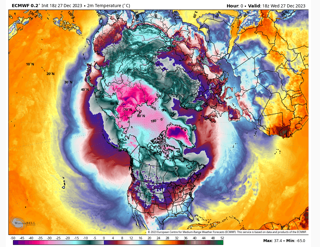
Current 850 anomalies

Current 850 temps

Forecasted 850 temps in 4 days
heehaw453- Advanced Forecaster

- Posts : 3906
Reputation : 86
Join date : 2014-01-20
Location : Bedminster Township, PA Elevation 600' ASL
 Re: Long Range Thread 27.0
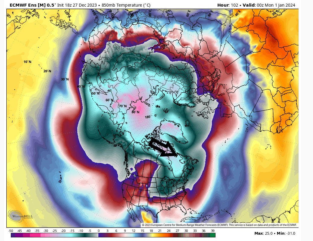
heehaw453 wrote:Sroc my friend with all due respect the surface and mid-level air over 1/3 of northern Greenland right now is the coldest on the planet by at least 30F. It's not splitting hairs and it's important implications as the NAO goes negative. If you look at the 850 anomalies on the eastern hemisphere (2nd pic) the only large anomaly of cold air is in eastern Siberia and is poised to start spilling over to AK and Canada as the EPO opens up. In general based on the 850 anomalies I don't consider the northern hemisphere a cold look whatsoever regardless of which side of the globe you are on.
I spoke 7 weeks ago about the slow start to eastern CA snow fall and in December became increasingly concerned to see NNE too be very slow starting. It was clear we had no cross polar flow to allow some of that Siberian air over and moreover we weren't oozing down cold air from CA as we lost the AO/NAO support. That's the key IMO to why this month has been horrendous.
I don't think we need a SPV split for cold enough air and a major split could make things worse depending on how it orients itself. However, I do think some split is inevitable, but the extent of which very precarious. I believe as NAO starts to go negative it will displace some of the very cold air in Greenland southward and also start pinching off pieces of the TPV at times to cool things down too. Also as said before the better EPO coupled with the +PNA will allow for some cross polar flow. That's cold enough air IMO to get the job done for snow. I'm quite confident though losing NAO support means it'd be close the shades time in this setup.
Current surface temps
Current 850 anomalies
Current 850 temps
Forecasted 850 temps in 4 days
First I don't really think we are that far off in our mind sets; rather, I think we are looking at the same box from slightly different perspectives. That said Greenland is almost always the coldest place on the planet in winter with its actual temps, even when its "above normal", because of its elevation and permanent ice. Now the only reason its below normal relative to avg right now is because it is sitting under a small lobe of the TPV. But you can see the largest lobe is over the Eastern Siberia location. So in general if you look at the 500mb height maps, where the lowest heights are will directly correlate with where the coldest temps are relative to averages. Now relative to avgs makes a difference. For example even though the area south of the Aleutians is colder than normal relative to avg its still warm air over water relative to say the avg temp over Greenland. Greenland could be 25* above average and still be -10f; whereas, the areas over the NE Pac could be 25* below normal and still be 35*f. So obv in terms of air masses just looking at temps relative to avg isnt as important, but it still needs consideration.


If we zoom into NA you can clearly see that at both 850 and the surface Most of Canada has been sitting at record temps AN, on the order of 18*+c AN. I outlined where the actual 30* f mark roughly has lived. That is WAY too far North. I dont care how cold it is in Greenland. If the NAO flipped tomorrow there is still way too much "warmth", relative warmth that will dilute that air by the time it leaks into the CONUS. This is unfort fact. So again my statement that "There is and has not been any cold air around is not in Accurate at all. The lack of CONUS snow pack, and minimal/BN snow pack in most of Canada is another check mark to that idea...for now.


Now regarding the Strat warming that has taken place this month. I want to be very clear about something, a start warming and what we would call a true "sudden stratospheric warming event(SSWE)" are not the same. The def of a true SSWE is: is an event in which polar stratospheric temperatures rise by several tens of kelvins over the course of a few days. The warming is preceded by a slowing then reversal of the westerly winds in the stratospheric polar vortex. SSWs occur about six times per decade in the northern hemisphere, and about once every 20-30 years in the southern hemisphere.
This did not take place this month. Winds did not reverse. But the warming event that did take place did in fact affect the SPV in such a way that it kicked it over to the other side of the globe. When there isnt a true SSWE, it is not coincidence to see the trop PV lobes be found under where the lowest Strat PV height anomalies are located; esp when the SPV lines throughout the strat where they seem to have been this month. You can refer to last nights write up for more details.

Now like I said last night the next couple of weeks the SPV will be in the process of reshuffling and repositioning. Again you can clearly see that depending on where the SPV is situated dictates where the 500mb TPV lobes are oriented and consequently where the coldest 850 and surface temp anomalies live. The next images are the euro 105 hrs out, followed by the end of the euro run(hr 240). Pay attention to where these players are as described a sentence or two ago.
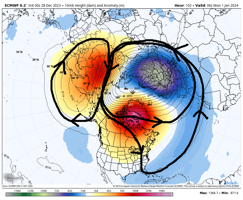


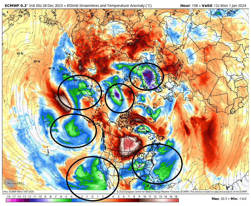


So again without a true reversal of the Strat winds, positioning of the SPV is critical to allowing the TPV to be nearby. Up through now this has not been the case which has resulted in no white for anyone because there really hasnt been any true cold air mass close enough to matter. That said the forecast seems to indicate that is changing which like has been mentioned in other posts its a process. A model forecast is only a forecast. It is not reality yet. The NAO is looking to go neg, the AO is looking to go negative. Unfort though the EPO is not going neg; rather, it is neg and is shifting to neutral, and the PNA which has been pos is shifting to negative. So we wait yet again to see how it shakes out. I am not punting anything and remain cautiously optimistic.
_________________
"In weather and in life, there's no winning and losing; there's only winning and learning."
WINTER 2012/2013 TOTALS 43.65"WINTER 2017/2018 TOTALS 62.85" WINTER 2022/2023 TOTALS 4.9"
WINTER 2013/2014 TOTALS 64.85"WINTER 2018/2019 TOTALS 14.25" WINTER 2023/2024 TOTALS 13.1"
WINTER 2014/2015 TOTALS 71.20"WINTER 2019/2020 TOTALS 6.35"
WINTER 2015/2016 TOTALS 35.00"WINTER 2020/2021 TOTALS 37.75"
WINTER 2016/2017 TOTALS 42.25"WINTER 2021/2022 TOTALS 31.65"

sroc4- Admin

- Posts : 8331
Reputation : 301
Join date : 2013-01-07
Location : Wading River, LI
 Re: Long Range Thread 27.0
rb924119- Meteorologist

- Posts : 6890
Reputation : 194
Join date : 2013-02-06
Age : 32
Location : Greentown, Pa
 Re: Long Range Thread 27.0
rb924119 wrote:The reversal of the Stratospheric winds is irrelevant, Scot; it’s a byproduct of the warming. The warming is what effects the actual changes in the atmosphere, not the wind reversal.And with the warming where it is, you’re going to have a “shadow” vortex develop equatorward of it, relative to averages
That’s my exact point Ray. Esp when there is no reversal the position of the SPV is critical. Up through now it’s position has been poorly oriented for most of NA.
_________________
"In weather and in life, there's no winning and losing; there's only winning and learning."
WINTER 2012/2013 TOTALS 43.65"WINTER 2017/2018 TOTALS 62.85" WINTER 2022/2023 TOTALS 4.9"
WINTER 2013/2014 TOTALS 64.85"WINTER 2018/2019 TOTALS 14.25" WINTER 2023/2024 TOTALS 13.1"
WINTER 2014/2015 TOTALS 71.20"WINTER 2019/2020 TOTALS 6.35"
WINTER 2015/2016 TOTALS 35.00"WINTER 2020/2021 TOTALS 37.75"
WINTER 2016/2017 TOTALS 42.25"WINTER 2021/2022 TOTALS 31.65"

sroc4- Admin

- Posts : 8331
Reputation : 301
Join date : 2013-01-07
Location : Wading River, LI
 Re: Long Range Thread 27.0
_________________
"In weather and in life, there's no winning and losing; there's only winning and learning."
WINTER 2012/2013 TOTALS 43.65"WINTER 2017/2018 TOTALS 62.85" WINTER 2022/2023 TOTALS 4.9"
WINTER 2013/2014 TOTALS 64.85"WINTER 2018/2019 TOTALS 14.25" WINTER 2023/2024 TOTALS 13.1"
WINTER 2014/2015 TOTALS 71.20"WINTER 2019/2020 TOTALS 6.35"
WINTER 2015/2016 TOTALS 35.00"WINTER 2020/2021 TOTALS 37.75"
WINTER 2016/2017 TOTALS 42.25"WINTER 2021/2022 TOTALS 31.65"

sroc4- Admin

- Posts : 8331
Reputation : 301
Join date : 2013-01-07
Location : Wading River, LI
 Re: Long Range Thread 27.0
sroc4 wrote:rb924119 wrote:The reversal of the Stratospheric winds is irrelevant, Scot; it’s a byproduct of the warming. The warming is what effects the actual changes in the atmosphere, not the wind reversal.And with the warming where it is, you’re going to have a “shadow” vortex develop equatorward of it, relative to averages
That’s my exact point Ray. Esp when there is no reversal the position of the SPV is critical. Up through now it’s position has been poorly oriented for most of NA.
Ignore the reversal, it’s irrelevant to the sensible weather. The only thing it satisfies is tue textbook definition. The evolution of the warming is what matters. The warming in the Stratosphere that you currently see on maps has been ongoing since the first week of December. Those fluxes are going to start impacting the Troposphere next week. So to say that the state of the Stra today is effectikgnthe weather today isn’t fair. You’d have to look at November to see how the Strat evolved in order to make the argument you’re making. That’s my point.
rb924119- Meteorologist

- Posts : 6890
Reputation : 194
Join date : 2013-02-06
Age : 32
Location : Greentown, Pa
rb924119- Meteorologist

- Posts : 6890
Reputation : 194
Join date : 2013-02-06
Age : 32
Location : Greentown, Pa
Page 20 of 40 •  1 ... 11 ... 19, 20, 21 ... 30 ... 40
|
|
|

 Home
Home

