Long Range Thread 27.0
Page 1 of 40 • 1, 2, 3 ... 20 ... 40 
 Long Range Thread 27.0
Typically come the start of the second week of Sept or so, we begin to look at the Siberian snow cover, and the rate at which it occurs between now through October and its correlation with the AO and Stratospheric influence. This is based of Dr Judah Cohen's many years of research. Here is the link to his blog. As we head deeper he updates it on a weekly bases I believe. Last update was Sept 5th. https://www.aer.com/science-research/climate-weather/arctic-oscillation/
In a nutshell, the more extensive and rapid the Siberian snow growth between mid Sept; through all of October, the higher statistical chances we have for a more persistent neg
AO(Arctic Oscillation), and higher chances for Stratospheric warming events during the winter months that lead to high latitude blocking such as a -AO, -NAO, etc..
Obviously this is not an exact science. This information has to get plugged into the big picture complex equation along with all the other variables such as ENSO status, QBO phases, and other large scale Oceanic SSTA configurations in the Pacific, Atlantic, and Indian oceans, etc, etc...to name a few.
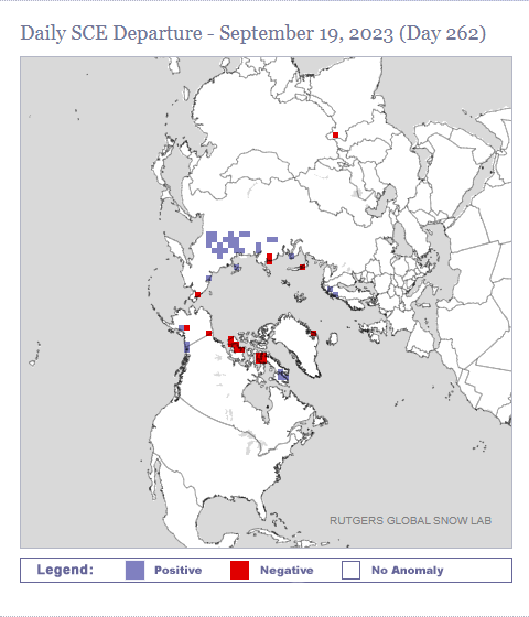
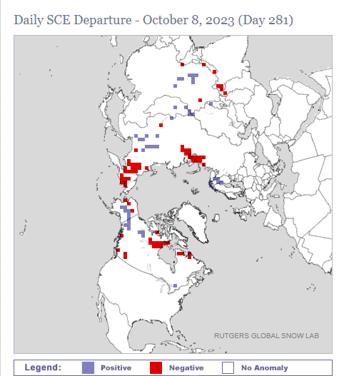
As you can see in the early going the Siberian snow cover is off to a relatively fast start with above normal snow, so far, in the northern tier of Siberia. That said last year was pretty much the exact same as what you see below ad we know how last year turned out.
I will try and get an ENSO update into the LR thread in the upcoming week or so. If you recall some of R(Ray's) discussion on this we wanted to se Enso region 1+2 begin to cool while Enso regions 3.4 cont to warm. Put another way we want the warmest anomalies in an El Nino winter to be centered in the central Pacific; not the eastern Pacific. All the trends over the past month have been pointing in that direction. There i still a long way to go with this and time for things to change, but again as of this writing all good indicators if you're a cold ad snow lover.
_________________
"In weather and in life, there's no winning and losing; there's only winning and learning."
WINTER 2012/2013 TOTALS 43.65"WINTER 2017/2018 TOTALS 62.85" WINTER 2022/2023 TOTALS 4.9"
WINTER 2013/2014 TOTALS 64.85"WINTER 2018/2019 TOTALS 14.25" WINTER 2023/2024 TOTALS 13.1"
WINTER 2014/2015 TOTALS 71.20"WINTER 2019/2020 TOTALS 6.35"
WINTER 2015/2016 TOTALS 35.00"WINTER 2020/2021 TOTALS 37.75"
WINTER 2016/2017 TOTALS 42.25"WINTER 2021/2022 TOTALS 31.65"

sroc4- Admin

- Posts : 8354
Reputation : 302
Join date : 2013-01-07
Location : Wading River, LI
Frank_Wx, Radz, kalleg, billg315 and SENJsnowman like this post
 Re: Long Range Thread 27.0

weatherwatchermom- Senior Enthusiast

- Posts : 3793
Reputation : 78
Join date : 2014-11-25
Location : Hazlet Township, NJ
sroc4 likes this post
 Re: Long Range Thread 27.0
rb924119- Meteorologist

- Posts : 6928
Reputation : 194
Join date : 2013-02-06
Age : 32
Location : Greentown, Pa
sroc4, kalleg and billg315 like this post
 Re: Long Range Thread 27.0
Some models have it peaking now - good sign.
_________________
Mugs
AKA:King: Snow Weenie
Self Proclaimed
WINTER 2014-15 : 55.12" +.02 for 6 coatings (avg. 35")
WINTER 2015-16 Total - 29.8" (Avg 35")
WINTER 2016-17 : 39.5" so far

amugs- Advanced Forecaster - Mod

- Posts : 15095
Reputation : 213
Join date : 2013-01-07
Age : 54
Location : Hillsdale,NJ
 Re: Long Range Thread 27.0
_________________
Mugs
AKA:King: Snow Weenie
Self Proclaimed
WINTER 2014-15 : 55.12" +.02 for 6 coatings (avg. 35")
WINTER 2015-16 Total - 29.8" (Avg 35")
WINTER 2016-17 : 39.5" so far

amugs- Advanced Forecaster - Mod

- Posts : 15095
Reputation : 213
Join date : 2013-01-07
Age : 54
Location : Hillsdale,NJ
 Re: Long Range Thread 27.0
_________________
Mugs
AKA:King: Snow Weenie
Self Proclaimed
WINTER 2014-15 : 55.12" +.02 for 6 coatings (avg. 35")
WINTER 2015-16 Total - 29.8" (Avg 35")
WINTER 2016-17 : 39.5" so far

amugs- Advanced Forecaster - Mod

- Posts : 15095
Reputation : 213
Join date : 2013-01-07
Age : 54
Location : Hillsdale,NJ
kalleg and weatherwatchermom like this post
 Re: Long Range Thread 27.0
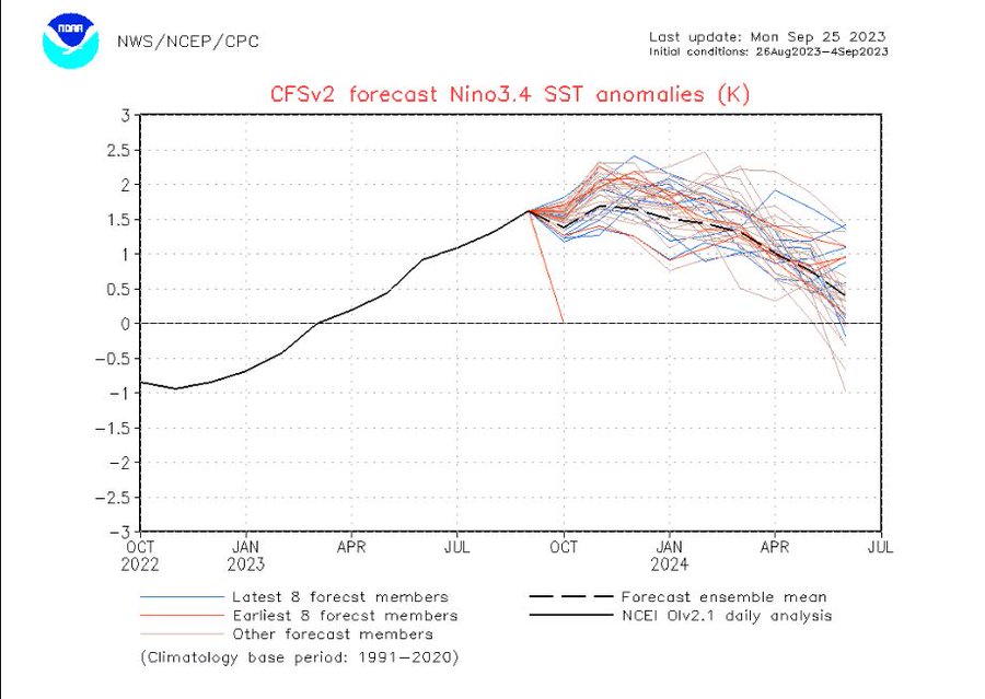
Good sign for upcoming winter if it verifies
_________________
Mugs
AKA:King: Snow Weenie
Self Proclaimed
WINTER 2014-15 : 55.12" +.02 for 6 coatings (avg. 35")
WINTER 2015-16 Total - 29.8" (Avg 35")
WINTER 2016-17 : 39.5" so far

amugs- Advanced Forecaster - Mod

- Posts : 15095
Reputation : 213
Join date : 2013-01-07
Age : 54
Location : Hillsdale,NJ
kalleg likes this post
 Re: Long Range Thread 27.0
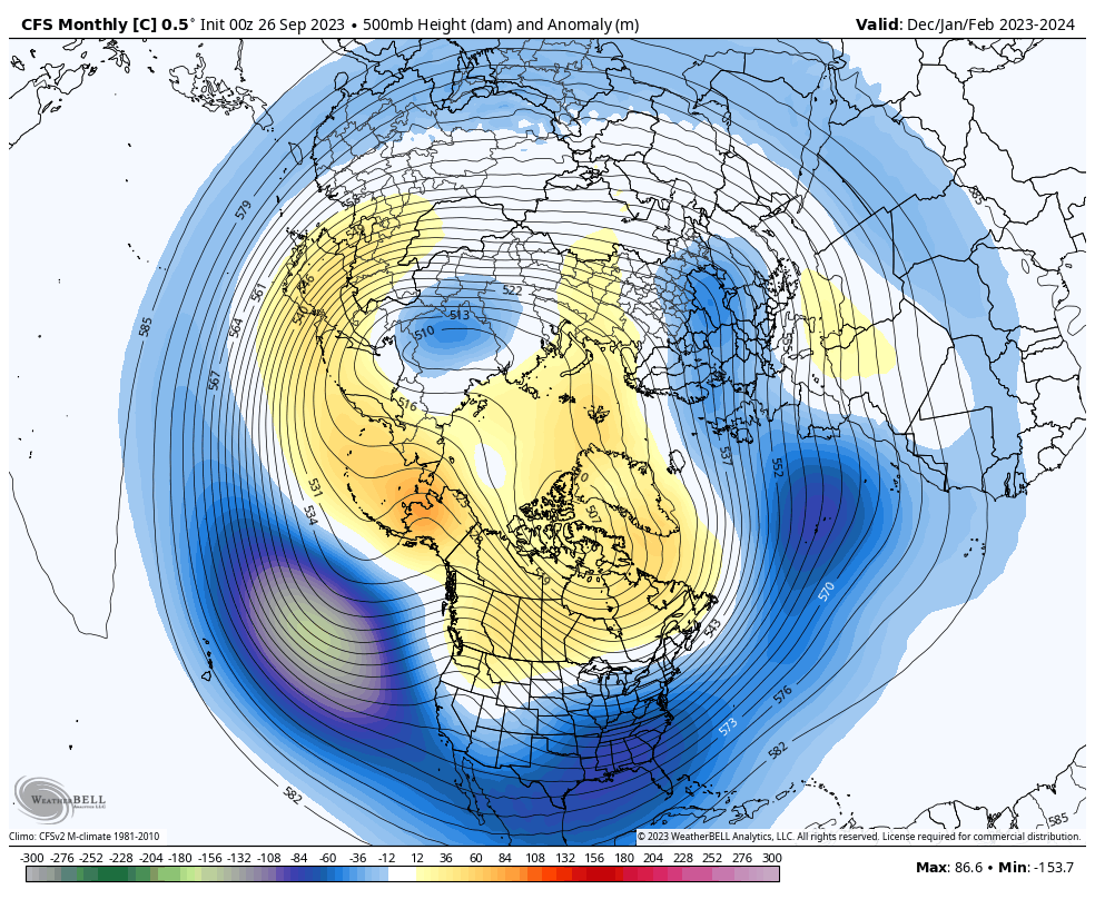
-EPO, AO and NAO
A trough NE of Hawaii and over Europe to boot,
_________________
Mugs
AKA:King: Snow Weenie
Self Proclaimed
WINTER 2014-15 : 55.12" +.02 for 6 coatings (avg. 35")
WINTER 2015-16 Total - 29.8" (Avg 35")
WINTER 2016-17 : 39.5" so far

amugs- Advanced Forecaster - Mod

- Posts : 15095
Reputation : 213
Join date : 2013-01-07
Age : 54
Location : Hillsdale,NJ
kalleg and MattyICE like this post
 Re: Long Range Thread 27.0
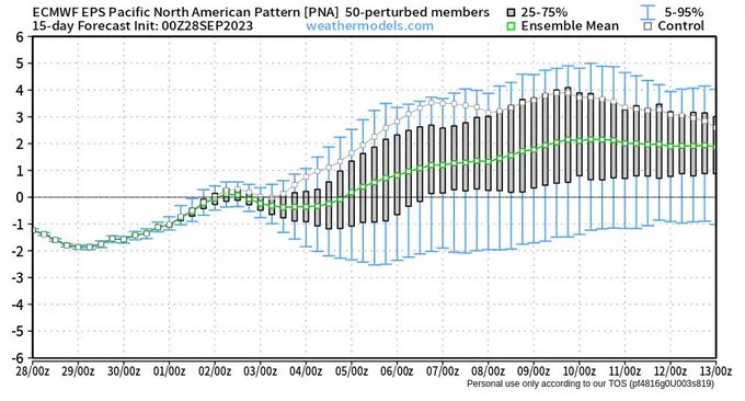
Ridge in West = Trough in east - watch for coastals, cutters
_________________
Mugs
AKA:King: Snow Weenie
Self Proclaimed
WINTER 2014-15 : 55.12" +.02 for 6 coatings (avg. 35")
WINTER 2015-16 Total - 29.8" (Avg 35")
WINTER 2016-17 : 39.5" so far

amugs- Advanced Forecaster - Mod

- Posts : 15095
Reputation : 213
Join date : 2013-01-07
Age : 54
Location : Hillsdale,NJ
MattyICE likes this post
 Re: Long Range Thread 27.0
_________________
_______________________________________________________________________________________________________
CLICK HERE to view NJ Strong Snowstorm Classifications
sroc4, kalleg, missmorris and weatherwatchermom like this post
 Re: Long Range Thread 27.0
USING THE PAST 92-DAYS
— Mike Masco (@MikeMasco) October 8, 2023
TO FORECAST TO FUTURE..
I am a believer in pattern recognition as a path to figuring out the long range forecast ahead. When we look at the overall progression of the 500mb pattern (show below) you see a consistent pattern of high latitude blocking over… pic.twitter.com/4QCclE1C9n
_________________
Mugs
AKA:King: Snow Weenie
Self Proclaimed
WINTER 2014-15 : 55.12" +.02 for 6 coatings (avg. 35")
WINTER 2015-16 Total - 29.8" (Avg 35")
WINTER 2016-17 : 39.5" so far

amugs- Advanced Forecaster - Mod

- Posts : 15095
Reputation : 213
Join date : 2013-01-07
Age : 54
Location : Hillsdale,NJ
 Re: Long Range Thread 27.0
Here is a snippet from Dr J Cohen's latest Blog from Oct 3rd. Here is the link for the full blog:
https://www.aer.com/science-research/climate-weather/arctic-oscillation/
Currently snow cover extent across Siberia is close to average for this early date in the snow advance season (see Figure ii). But I do expect snow cover advance to either slow down or even retreat next week. And with the overall circulation across Asia settling into a western trough/eastern ridge pattern the prospects for above normal snow cover for the month of October are looking bleak. This is especially surprising to me given that snow cover extent has been perennially above normal for the past decade (last below normal month of October was in 2011) and for an overwhelming majority of the past two decades and that it is an El Niño fall, which has favored higher snow cover extent than La Niña.
Assuming Eurasian snow cover extent is below normal this month, this would favor an overall strong PV in the winter months and milder temperatures across the mid-latitude continents of the NH probably more so for the Eastern US and East Asia than Europe, though Europe seems to be warm these days regardless.
But the pattern looks to be mostly progressive and maybe by the end of October the pattern will be more conducive to more rapid snow cover advance across Siberia. Certainly, if you believe the CFS, November looks like a much more interesting month (see Figure 12). But when I start pointing to the CFS as my best sign of hope, you know that I am desperate.
Of course, if I feel that the community relies too heavily on ENSO in seasonal forecasting, so I don’t want to overplay the accuracy of snow cover alone in making a winter forecast (a fact many are very happy to point out to me) and there seems to be many potentially important players in determining the character of this upcoming winter. El Niño is related to a deeper Aleutian low and that seems to be a more common feature in the weather maps of late and shows up nicely in Figure 8. A deeper Aleutian low this winter would favor a weaker PV and possibly colder temperatures in the Eastern US.
Besides snow cover I also look at Arctic sea ice extent but not much new from the most recent blog and I will focus on that more next month while I focus on snow cover for this month.
_________________
"In weather and in life, there's no winning and losing; there's only winning and learning."
WINTER 2012/2013 TOTALS 43.65"WINTER 2017/2018 TOTALS 62.85" WINTER 2022/2023 TOTALS 4.9"
WINTER 2013/2014 TOTALS 64.85"WINTER 2018/2019 TOTALS 14.25" WINTER 2023/2024 TOTALS 13.1"
WINTER 2014/2015 TOTALS 71.20"WINTER 2019/2020 TOTALS 6.35"
WINTER 2015/2016 TOTALS 35.00"WINTER 2020/2021 TOTALS 37.75"
WINTER 2016/2017 TOTALS 42.25"WINTER 2021/2022 TOTALS 31.65"

sroc4- Admin

- Posts : 8354
Reputation : 302
Join date : 2013-01-07
Location : Wading River, LI
docstox12 likes this post
 Re: Long Range Thread 27.0
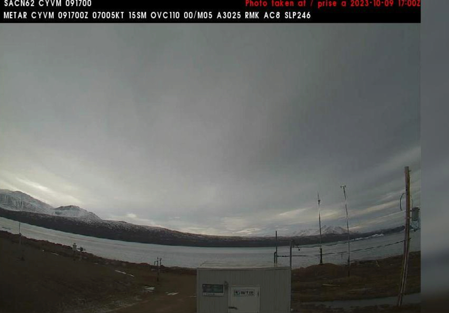
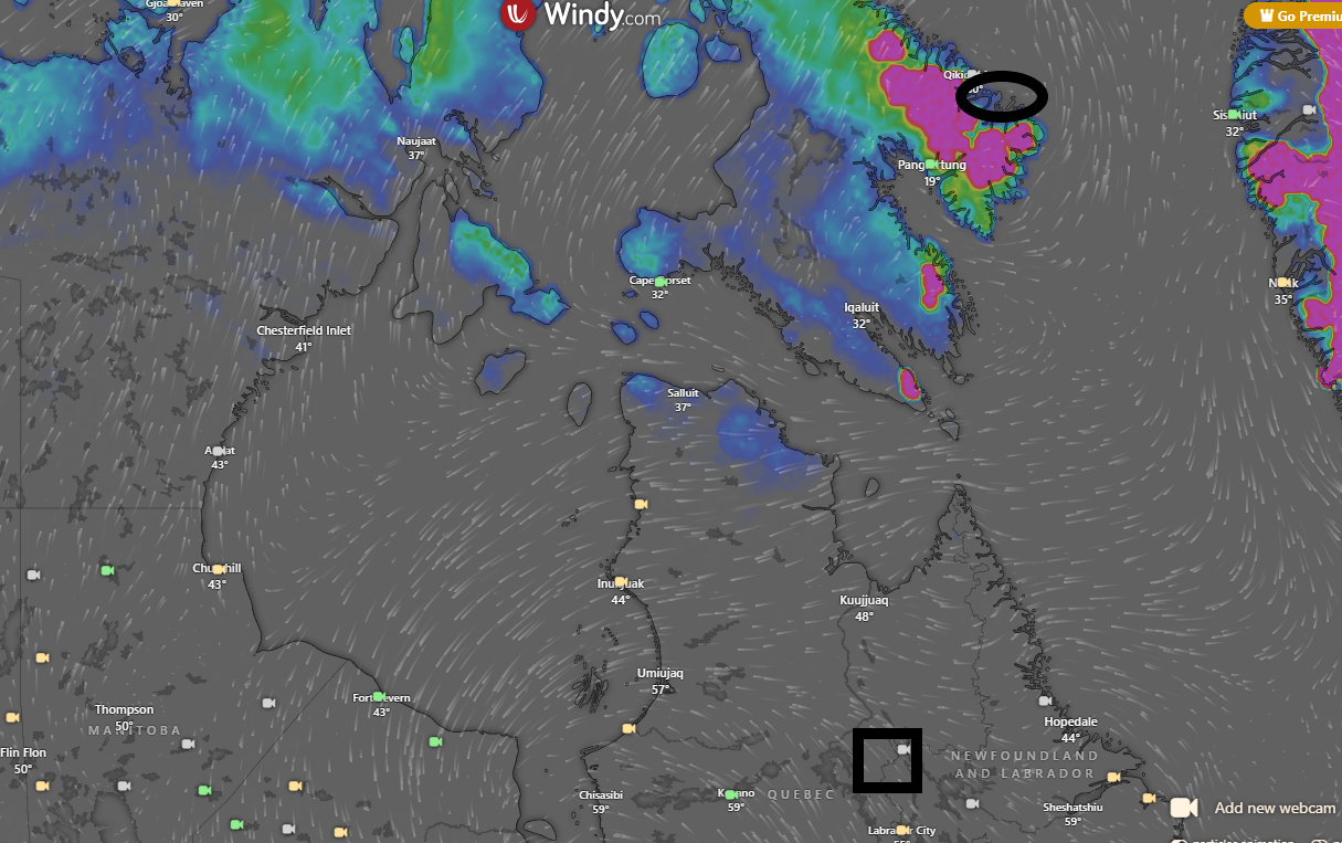
I'll speak to eastern Canada. Places like Labrador City (squared) October is historically a good snowfall month. Average about 16" or so. Last year they had a few inches in October and this is what eastern CA looks like now the darker the colors the more snow depth. Even the extreme coast of Baffin Island, Nunuvat (circled) by this time of year should have a 1' of snow OTG. Here's a web cam shot of it. I have no idea what this winter season holds but given 2019-20/2022-23, I'm skeptical.
heehaw453- Advanced Forecaster

- Posts : 3906
Reputation : 86
Join date : 2014-01-20
Location : Bedminster Township, PA Elevation 600' ASL
docstox12 and rb924119 like this post
 Re: Long Range Thread 27.0

docstox12- Wx Statistician Guru

- Posts : 8530
Reputation : 222
Join date : 2013-01-07
Age : 73
Location : Monroe NY
 Re: Long Range Thread 27.0
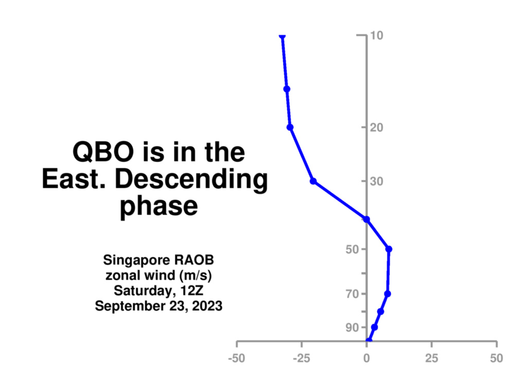
The east QBO descending further down is shown here in the European forecast model as we go into Fall and Winter. This forecast confirms that a mature negative QBO phase could be in place for the 2023/24 Winter season. pic.twitter.com/ozrWsMgsXm
— Mike Masco (@MikeMasco) October 12, 2023
_________________
Mugs
AKA:King: Snow Weenie
Self Proclaimed
WINTER 2014-15 : 55.12" +.02 for 6 coatings (avg. 35")
WINTER 2015-16 Total - 29.8" (Avg 35")
WINTER 2016-17 : 39.5" so far

amugs- Advanced Forecaster - Mod

- Posts : 15095
Reputation : 213
Join date : 2013-01-07
Age : 54
Location : Hillsdale,NJ
rb924119 likes this post
 Re: Long Range Thread 27.0

docstox12- Wx Statistician Guru

- Posts : 8530
Reputation : 222
Join date : 2013-01-07
Age : 73
Location : Monroe NY
 Re: Long Range Thread 27.0
rb924119- Meteorologist

- Posts : 6928
Reputation : 194
Join date : 2013-02-06
Age : 32
Location : Greentown, Pa
 Re: Long Range Thread 27.0
Scott, interesting post about Siberian snow extent, although, personally, I don’t put much stock into it. I’m not quite sure that it has as stout of an effect as it’s thought to. Just my opinion, though.
rb924119- Meteorologist

- Posts : 6928
Reputation : 194
Join date : 2013-02-06
Age : 32
Location : Greentown, Pa
 Re: Long Range Thread 27.0
rb924119 wrote:Heehaw, good to see you back! Regarding your post, ridging over eastern Canada/Baffin Island can be a good thing
Scott, interesting post about Siberian snow extent, although, personally, I don’t put much stock into it. I’m not quite sure that it has as stout of an effect as it’s thought to. Just my opinion, though.
Well I suppose like everything else it’s all a part of the big picture. If there is an El Niño how strong/weak is it and is it east/west/central/basin wide. Is there above/below avg Siberian snow growth and cover? If there is what other major pattern drivers are present to either enhance or mute the Siberian snow cover anomalies? Like you said it’s a jig saw puzzle. The state of QBO is looking like a pattern enhancer combined with the El Niño enhancing the transport of warmth into the Strat which could be one reason the below avg Siberian snow might not be that big a deal this year. Things are def beginning to show itself but we still have a ways to go to see how it all shakes out. MJO and OLR anomalies over the past month or too have been interesting as well should this same pattern maintain deeper into the cold months.
_________________
"In weather and in life, there's no winning and losing; there's only winning and learning."
WINTER 2012/2013 TOTALS 43.65"WINTER 2017/2018 TOTALS 62.85" WINTER 2022/2023 TOTALS 4.9"
WINTER 2013/2014 TOTALS 64.85"WINTER 2018/2019 TOTALS 14.25" WINTER 2023/2024 TOTALS 13.1"
WINTER 2014/2015 TOTALS 71.20"WINTER 2019/2020 TOTALS 6.35"
WINTER 2015/2016 TOTALS 35.00"WINTER 2020/2021 TOTALS 37.75"
WINTER 2016/2017 TOTALS 42.25"WINTER 2021/2022 TOTALS 31.65"

sroc4- Admin

- Posts : 8354
Reputation : 302
Join date : 2013-01-07
Location : Wading River, LI
docstox12 and rb924119 like this post
 Re: Long Range Thread 27.0
sroc4 wrote:rb924119 wrote:Heehaw, good to see you back! Regarding your post, ridging over eastern Canada/Baffin Island can be a good thing
Scott, interesting post about Siberian snow extent, although, personally, I don’t put much stock into it. I’m not quite sure that it has as stout of an effect as it’s thought to. Just my opinion, though.
Well I suppose like everything else it’s all a part of the big picture. If there is an El Niño how strong/weak is it and is it east/west/central/basin wide. Is there above/below avg Siberian snow growth and cover? If there is what other major pattern drivers are present to either enhance or mute the Siberian snow cover anomalies? Like you said it’s a jig saw puzzle. The state of QBO is looking like a pattern enhancer combined with the El Niño enhancing the transport of warmth into the Strat which could be one reason the below avg Siberian snow might not be that big a deal this year. Things are def beginning to show itself but we still have a ways to go to see how it all shakes out. MJO and OLR anomalies over the past month or too have been interesting as well should this same pattern maintain deeper into the cold months.
Great point! When I actively traded for 20 years, I would use 10 to 15 technical indicators to make a decision .I would see how many pointed to the good possibilty of a trade being profitable.If you got 75% of them to line up, you had a good chance.They don't all line up like ducks in a row, but if the majority do, well....

docstox12- Wx Statistician Guru

- Posts : 8530
Reputation : 222
Join date : 2013-01-07
Age : 73
Location : Monroe NY
sroc4 and kalleg like this post
 Re: Long Range Thread 27.0
Late last march we showed the pattern we expected to evolve for this winter keying on analogs coming out of last winter and the climate cycle response we are in, This came up with the threat of the big winter. latest JMA LOOKS LIKE OUR ANALOGS,from last spring!
— The American Storm (@BigJoeBastardi) October 16, 2023
IMPLIES MAJOR… pic.twitter.com/w9UasKbZho
_________________
Mugs
AKA:King: Snow Weenie
Self Proclaimed
WINTER 2014-15 : 55.12" +.02 for 6 coatings (avg. 35")
WINTER 2015-16 Total - 29.8" (Avg 35")
WINTER 2016-17 : 39.5" so far

amugs- Advanced Forecaster - Mod

- Posts : 15095
Reputation : 213
Join date : 2013-01-07
Age : 54
Location : Hillsdale,NJ
 Re: Long Range Thread 27.0
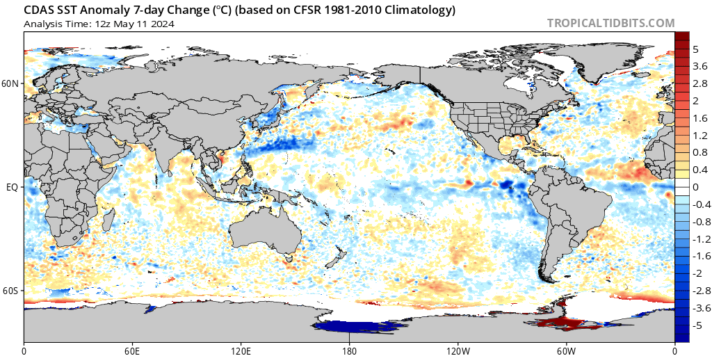
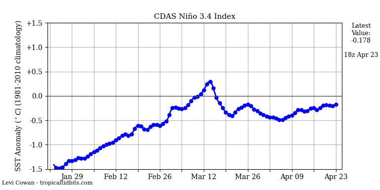
1.2 cooling which is good
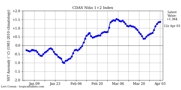
Good forecast for winter to cool down 1.2 so it is not East Based Nino
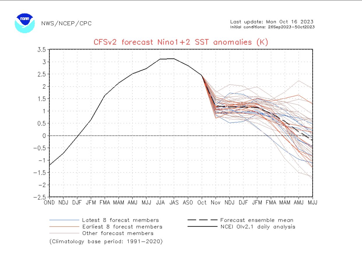
3.4 Warming which is good too
_________________
Mugs
AKA:King: Snow Weenie
Self Proclaimed
WINTER 2014-15 : 55.12" +.02 for 6 coatings (avg. 35")
WINTER 2015-16 Total - 29.8" (Avg 35")
WINTER 2016-17 : 39.5" so far

amugs- Advanced Forecaster - Mod

- Posts : 15095
Reputation : 213
Join date : 2013-01-07
Age : 54
Location : Hillsdale,NJ
kalleg likes this post
 Re: Long Range Thread 27.0
_________________
Mugs
AKA:King: Snow Weenie
Self Proclaimed
WINTER 2014-15 : 55.12" +.02 for 6 coatings (avg. 35")
WINTER 2015-16 Total - 29.8" (Avg 35")
WINTER 2016-17 : 39.5" so far

amugs- Advanced Forecaster - Mod

- Posts : 15095
Reputation : 213
Join date : 2013-01-07
Age : 54
Location : Hillsdale,NJ
 Re: Long Range Thread 27.0
https://wxrisk.com/wp-content/uploads/_pda/2023/10/winter-2023-24.pdf
_________________
"In weather and in life, there's no winning and losing; there's only winning and learning."
WINTER 2012/2013 TOTALS 43.65"WINTER 2017/2018 TOTALS 62.85" WINTER 2022/2023 TOTALS 4.9"
WINTER 2013/2014 TOTALS 64.85"WINTER 2018/2019 TOTALS 14.25" WINTER 2023/2024 TOTALS 13.1"
WINTER 2014/2015 TOTALS 71.20"WINTER 2019/2020 TOTALS 6.35"
WINTER 2015/2016 TOTALS 35.00"WINTER 2020/2021 TOTALS 37.75"
WINTER 2016/2017 TOTALS 42.25"WINTER 2021/2022 TOTALS 31.65"

sroc4- Admin

- Posts : 8354
Reputation : 302
Join date : 2013-01-07
Location : Wading River, LI
 Re: Long Range Thread 27.0
https://arcfieldweather.com/blog/2023/10/17/2023-2024-winter-outlook-by-arcfield-weather
_________________
Mugs
AKA:King: Snow Weenie
Self Proclaimed
WINTER 2014-15 : 55.12" +.02 for 6 coatings (avg. 35")
WINTER 2015-16 Total - 29.8" (Avg 35")
WINTER 2016-17 : 39.5" so far

amugs- Advanced Forecaster - Mod

- Posts : 15095
Reputation : 213
Join date : 2013-01-07
Age : 54
Location : Hillsdale,NJ
Page 1 of 40 • 1, 2, 3 ... 20 ... 40 
|
|
|

 Home
Home