Feruary 12th-13th Pre-Valentines Day SNOW MAPS
+5
Frank_Wx
aiannone
billg315
frank 638
sroc4
9 posters
 Feruary 12th-13th Pre-Valentines Day SNOW MAPS
_________________
"In weather and in life, there's no winning and losing; there's only winning and learning."
WINTER 2012/2013 TOTALS 43.65"WINTER 2017/2018 TOTALS 62.85" WINTER 2022/2023 TOTALS 4.9"
WINTER 2013/2014 TOTALS 64.85"WINTER 2018/2019 TOTALS 14.25" WINTER 2023/2024 TOTALS 13.1"
WINTER 2014/2015 TOTALS 71.20"WINTER 2019/2020 TOTALS 6.35"
WINTER 2015/2016 TOTALS 35.00"WINTER 2020/2021 TOTALS 37.75"
WINTER 2016/2017 TOTALS 42.25"WINTER 2021/2022 TOTALS 31.65"

sroc4- Admin

- Posts : 8354
Reputation : 302
Join date : 2013-01-07
Location : Wading River, LI
frank 638 likes this post
 Re: Feruary 12th-13th Pre-Valentines Day SNOW MAPS
I like what I’m seeing. I like the map so far and I hope this verifies because we need this.
frank 638- Senior Enthusiast

- Posts : 2843
Reputation : 37
Join date : 2016-01-01
Age : 40
Location : bronx ny
 Re: Feruary 12th-13th Pre-Valentines Day SNOW MAPS
Apologize in advance for my rudimentary art. Here’s my current map:
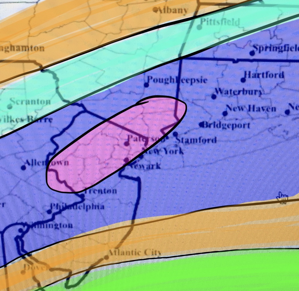
Green: Rain ending as an inch or so of snow.
Orange: 1-3”
Light Blue/Teal: 3-6”
Purple/Dark Blue: 4-8”
Pink: 8-10” (this area is less predictable and could shift anywhere in the 4-8 zone, so this is a best guess).
I usually try to have borders align (ie 4” max next to 4” min) but I really think there will be overlapping here where the cutoffs might not be that uniform.

billg315- Advanced Forecaster - Mod

- Posts : 4483
Reputation : 185
Join date : 2015-01-24
Age : 50
Location : Flemington, NJ
sroc4, docstox12, amugs, heehaw453 and weatherwatchermom like this post
 Re: Feruary 12th-13th Pre-Valentines Day SNOW MAPS
If there is going to be movement in my first call map, I'd mostly likely expect it would be for these zones to shift slightly north.

billg315- Advanced Forecaster - Mod

- Posts : 4483
Reputation : 185
Join date : 2015-01-24
Age : 50
Location : Flemington, NJ

aiannone- Senior Enthusiast - Mod

- Posts : 4815
Reputation : 92
Join date : 2013-01-07
Location : Saint James, LI (Northwest Suffolk Co.)
Goalscore1 likes this post
 Re: Feruary 12th-13th Pre-Valentines Day SNOW MAPS
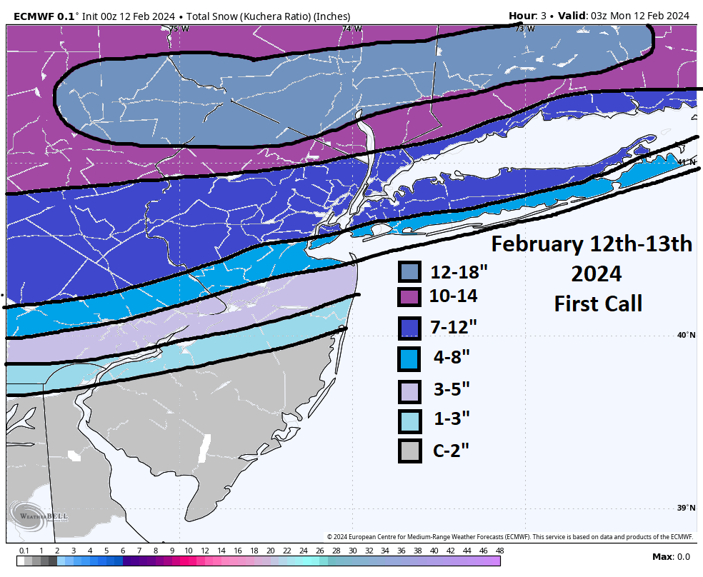
My 1st call

P.s. Bill I like your map!!

P.s. Bill I like your map!!
_________________
_______________________________________________________________________________________________________
CLICK HERE to view NJ Strong Snowstorm Classifications
kalleg, billg315 and JT33 like this post
 Re: Feruary 12th-13th Pre-Valentines Day SNOW MAPS
_________________
"In weather and in life, there's no winning and losing; there's only winning and learning."
WINTER 2012/2013 TOTALS 43.65"WINTER 2017/2018 TOTALS 62.85" WINTER 2022/2023 TOTALS 4.9"
WINTER 2013/2014 TOTALS 64.85"WINTER 2018/2019 TOTALS 14.25" WINTER 2023/2024 TOTALS 13.1"
WINTER 2014/2015 TOTALS 71.20"WINTER 2019/2020 TOTALS 6.35"
WINTER 2015/2016 TOTALS 35.00"WINTER 2020/2021 TOTALS 37.75"
WINTER 2016/2017 TOTALS 42.25"WINTER 2021/2022 TOTALS 31.65"

sroc4- Admin

- Posts : 8354
Reputation : 302
Join date : 2013-01-07
Location : Wading River, LI
Frank_Wx and billg315 like this post
 Re: Feruary 12th-13th Pre-Valentines Day SNOW MAPS
Revised map. Didn’t make many changes. Essentially accounting for sharp cutoff to north and lowering expectations for widespread 8+” area:
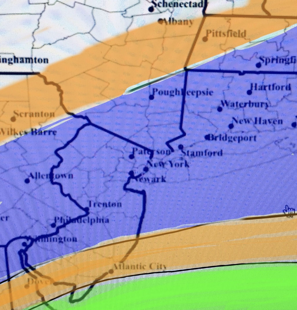
Green: Rain ending as a slushy inch or so.
Orange: 1-3” Snow
Purple/Dark Blue: 4-8”. Isolated areas in this zone could hit 10” if your locale gets under heavier banding.

Green: Rain ending as a slushy inch or so.
Orange: 1-3” Snow
Purple/Dark Blue: 4-8”. Isolated areas in this zone could hit 10” if your locale gets under heavier banding.

billg315- Advanced Forecaster - Mod

- Posts : 4483
Reputation : 185
Join date : 2015-01-24
Age : 50
Location : Flemington, NJ
Frank_Wx and sroc4 like this post
 Re: Feruary 12th-13th Pre-Valentines Day SNOW MAPS
Final


_________________
_______________________________________________________________________________________________________
CLICK HERE to view NJ Strong Snowstorm Classifications
sroc4, kalleg and billg315 like this post
 Re: Feruary 12th-13th Pre-Valentines Day SNOW MAPS
_________________
_______________________________________________________________________________________________________
CLICK HERE to view NJ Strong Snowstorm Classifications
heehaw453 and JT33 like this post
 Re: Feruary 12th-13th Pre-Valentines Day SNOW MAPS
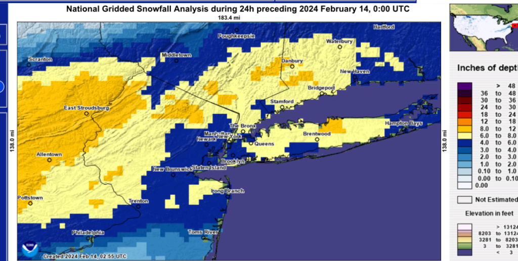
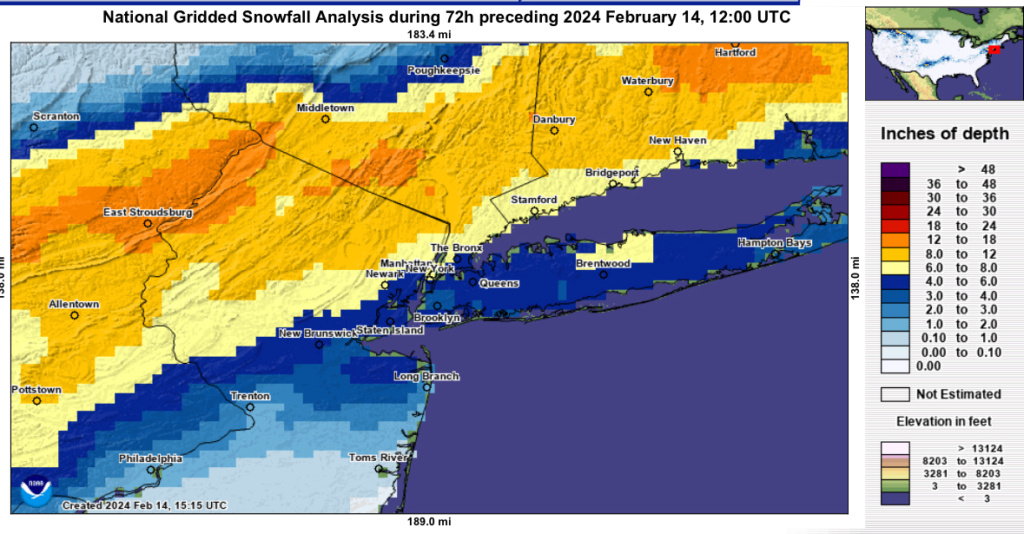
Not sure if this is the right place to comment on this NWS map or not, but I looked at this map close up for my area and it doesn't reflect the totals I saw for Bloomfield (I had 8" but the map shows blue 4-6") and Montclair (I had 7+ and the map again shows 4-6"). Also, I think Bob in Caldwell reported 9" (albeit 500 ft altitude) and the map again shows 4-6 for Caldwell. Just thought I'd mention it. I'm curious what other have seen locally compared to this map.
https://www.nohrsc.noaa.gov/snowfall_v2/

essexcountypete- Pro Enthusiast

- Posts : 783
Reputation : 12
Join date : 2013-12-09
Location : Bloomfield, NJ
 Re: Feruary 12th-13th Pre-Valentines Day SNOW MAPS
essexcountypete wrote:
Not sure if this is the right place to comment on this NWS map or not, but I looked at this map close up for my area and it doesn't reflect the totals I saw for Bloomfield (I had 8" but the map shows blue 4-6") and Montclair (I had 7+ and the map again shows 4-6"). Also, I think Bob in Caldwell reported 9" (albeit 500 ft altitude) and the map again shows 4-6 for Caldwell. Just thought I'd mention it. I'm curious what other have seen locally compared to this map.
https://www.nohrsc.noaa.gov/snowfall_v2/
The map is a horrible depiction of what actually fell.
All reports in Orange County NY were from 10.5 to 14 inches. They have most of Orange County in the 6-8 with a few areas of 8-12. Typical unfortunately.

CPcantmeasuresnow- Wx Statistician Guru

- Posts : 7274
Reputation : 230
Join date : 2013-01-07
Age : 103
Location : Eastern Orange County, NY
docstox12 and essexcountypete like this post
 Re: Feruary 12th-13th Pre-Valentines Day SNOW MAPS
I don't know CP. Maybe the Zookeeper found new work at the NWS. New title: Chief of Gridded Snowfall Analysis.

billg315- Advanced Forecaster - Mod

- Posts : 4483
Reputation : 185
Join date : 2015-01-24
Age : 50
Location : Flemington, NJ
 Re: Feruary 12th-13th Pre-Valentines Day SNOW MAPS
essexcountypete wrote:
Not sure if this is the right place to comment on this NWS map or not, but I looked at this map close up for my area and it doesn't reflect the totals I saw for Bloomfield (I had 8" but the map shows blue 4-6") and Montclair (I had 7+ and the map again shows 4-6"). Also, I think Bob in Caldwell reported 9" (albeit 500 ft altitude) and the map again shows 4-6 for Caldwell. Just thought I'd mention it. I'm curious what other have seen locally compared to this map.
https://www.nohrsc.noaa.gov/snowfall_v2/
Is this better? I don’t know why it keeps changing
_________________
_______________________________________________________________________________________________________
CLICK HERE to view NJ Strong Snowstorm Classifications
MattyICE likes this post
 Re: Feruary 12th-13th Pre-Valentines Day SNOW MAPS
Frank_Wx wrote:essexcountypete wrote:
Not sure if this is the right place to comment on this NWS map or not, but I looked at this map close up for my area and it doesn't reflect the totals I saw for Bloomfield (I had 8" but the map shows blue 4-6") and Montclair (I had 7+ and the map again shows 4-6"). Also, I think Bob in Caldwell reported 9" (albeit 500 ft altitude) and the map again shows 4-6 for Caldwell. Just thought I'd mention it. I'm curious what other have seen locally compared to this map.
https://www.nohrsc.noaa.gov/snowfall_v2/
Is this better? I don’t know why it keeps changing
Oh yeah, that's more like it. I guess they keep adding reports as they come in.

essexcountypete- Pro Enthusiast

- Posts : 783
Reputation : 12
Join date : 2013-12-09
Location : Bloomfield, NJ
 Re: Feruary 12th-13th Pre-Valentines Day SNOW MAPS
Frank_Wx wrote:essexcountypete wrote:
Not sure if this is the right place to comment on this NWS map or not, but I looked at this map close up for my area and it doesn't reflect the totals I saw for Bloomfield (I had 8" but the map shows blue 4-6") and Montclair (I had 7+ and the map again shows 4-6"). Also, I think Bob in Caldwell reported 9" (albeit 500 ft altitude) and the map again shows 4-6 for Caldwell. Just thought I'd mention it. I'm curious what other have seen locally compared to this map.
https://www.nohrsc.noaa.gov/snowfall_v2/
Is this better? I don’t know why it keeps changing
2nd one much better Frank.

docstox12- Wx Statistician Guru

- Posts : 8530
Reputation : 222
Join date : 2013-01-07
Age : 73
Location : Monroe NY
 Re: Feruary 12th-13th Pre-Valentines Day SNOW MAPS
Much more realistic yes.
MattyICE- Advanced Forecaster

- Posts : 249
Reputation : 6
Join date : 2017-11-10
Age : 38
Location : Clifton, NJ (Eastern Passaic County)
Permissions in this forum:
You cannot reply to topics in this forum|
|
|

 Home
Home