
 Search
Coastal Storm 9/25/14
Page 1 of 3 • 1, 2, 3 ![]()

Coastal Storm 9/25/14
![]() by Frank_Wx Tue Sep 23, 2014 3:45 pm
by Frank_Wx Tue Sep 23, 2014 3:45 pm
12z GFS:

12z EURO:

One positive that we can take out of this is we can use the rain. It has been drier than normal for much of the area. Also, this will not be a strong storm. Most models project it between 1010-1020 mb, which is not strong at all. As you can see from the GFS / EURO, the heaviest will come Thursday morning, between 7am - 11am.

Total rainfall map from the EURO is between 1.50-3.00 inches of rain. Judging by the current radar, these amounts are not out of the ordinary and I think 2-3 inches of rain could be the common range among most of the region. However, with additional models runs still to go, there is a chance this storm shifts east last minute and we avoid the heaviest rain, which would put us more in a 1-2 inch rainfall.

Wind wise, we are probably looking at gusts between 20-30 mph, less the further west you live. East end of Long Island will be looking at 30+ mph wind gusts. Like I said before, this is a weak storm so I am not worried about the wind. It has a lot of moisture though, so it will be quite rainy.
Timing:
Start: 2-3am Thursday
End: 4-5pm Thursday (still uncertain with end time, will update again tomorrow morning)
Last edited by Frank_Wx on Fri Sep 26, 2014 1:37 pm; edited 1 time in total
_________________
_______________________________________________________________________________________________________
CLICK HERE to view NJ Strong Snowstorm Classifications

Frank_Wx- Godzilla Seeker

- Posts : 21305
Reputation : 328
Join date : 2013-01-05
Age : 31
Location : Jersey City, NJ -

Re: Coastal Storm 9/25/14
![]() by Frank_Wx Tue Sep 23, 2014 3:46 pm
by Frank_Wx Tue Sep 23, 2014 3:46 pm

Lots of moisture associated with this storm. If it shifts west some more, there could be places that see rain amounts in excess of 3 inches. I will keep a close eye as always.
_________________
_______________________________________________________________________________________________________
CLICK HERE to view NJ Strong Snowstorm Classifications
Frank_Wx- Godzilla Seeker
- Posts : 21305
Reputation : 328
Join date : 2013-01-05
Age : 31
Location : Jersey City, NJ -
Re: Coastal Storm 9/25/14
![]() by jmanley32 Tue Sep 23, 2014 4:09 pm
by jmanley32 Tue Sep 23, 2014 4:09 pm

jmanley32- Senior Enthusiast

- Posts : 20512
Reputation : 108
Join date : 2013-12-12
Age : 42
Location : Yonkers, NY
Re: Coastal Storm 9/25/14
![]() by jmanley32 Tue Sep 23, 2014 4:15 pm
by jmanley32 Tue Sep 23, 2014 4:15 pm
jmanley32- Senior Enthusiast
- Posts : 20512
Reputation : 108
Join date : 2013-12-12
Age : 42
Location : Yonkers, NY
Re: Coastal Storm 9/25/14
![]() by Frank_Wx Tue Sep 23, 2014 4:29 pm
by Frank_Wx Tue Sep 23, 2014 4:29 pm
jmanley32 wrote:Thanks Frank nice update, is there any chance this deepens more than expected? I mean it already changed alot or is that stretching it too far? A wind driven rain (even 20mph is enough to make umbrullas useless. I will be sure to leave extra early Thursday as gosh knows the roads here in NYC area will be hell.
No, the upper air pattern is not condusive for a deepening storm. I do not even think there is much tropical activity involved with this storm. The 500mb maps show most of the energy coming in from the west. That is where the storm is getting most of its energy.
jmanley32 wrote:Another thought, being there is tropical moisture involved is there the potential for t-storms or possible tornados? Frank good to see your back on with wx-bell, best graphics in my book, but I do like the other one you use, what is that called?
No severe weather expected.
Yea, I just subscribed back to WeatherBell and StormVista
_________________
_______________________________________________________________________________________________________
CLICK HERE to view NJ Strong Snowstorm Classifications
Frank_Wx- Godzilla Seeker
- Posts : 21305
Reputation : 328
Join date : 2013-01-05
Age : 31
Location : Jersey City, NJ -
Re: Coastal Storm 9/25/14
![]() by jmanley32 Tue Sep 23, 2014 4:31 pm
by jmanley32 Tue Sep 23, 2014 4:31 pm

Update: 18z NAM keeps most the precip south of NYC, I don't usually go by NAM though it has been ok before. We will see.
jmanley32- Senior Enthusiast
- Posts : 20512
Reputation : 108
Join date : 2013-12-12
Age : 42
Location : Yonkers, NY
Re: Coastal Storm 9/25/14
![]() by Dunnzoo Tue Sep 23, 2014 4:47 pm
by Dunnzoo Tue Sep 23, 2014 4:47 pm
_________________
Janet
Snowfall winter of 2023-2024 17.5"
Snowfall winter of 2022-2023 6.0"
Snowfall winter of 2021-2022 17.6" 1" sleet 2/25/22
Snowfall winter of 2020-2021 51.1"
Snowfall winter of 2019-2020 8.5"
Snowfall winter of 2018-2019 25.1"
Snowfall winter of 2017-2018 51.9"
Snowfall winter of 2016-2017 45.6"
Snowfall winter of 2015-2016 29.5"
Snowfall winter of 2014-2015 50.55"
Snowfall winter of 2013-2014 66.5"

Dunnzoo- Senior Enthusiast - Mod

- Posts : 4884
Reputation : 68
Join date : 2013-01-11
Age : 62
Location : Westwood, NJ
Re: Coastal Storm 9/25/14
![]() by amugs Tue Sep 23, 2014 6:38 pm
by amugs Tue Sep 23, 2014 6:38 pm
Bring on the pattern change with coastal's I say and Janet that HP is progged to weaken as it moves east if I am reading it correctly.
Gotta love the weather - hope this happens with winter - woop!!
_________________
Mugs
AKA:King: Snow Weenie
Self Proclaimed
WINTER 2014-15 : 55.12" +.02 for 6 coatings (avg. 35")
WINTER 2015-16 Total - 29.8" (Avg 35")
WINTER 2016-17 : 39.5" so far

amugs- Advanced Forecaster - Mod
- Posts : 15093
Reputation : 213
Join date : 2013-01-07
Age : 54
Location : Hillsdale,NJ
Re: Coastal Storm 9/25/14
![]() by jmanley32 Tue Sep 23, 2014 7:09 pm
by jmanley32 Tue Sep 23, 2014 7:09 pm
jmanley32- Senior Enthusiast
- Posts : 20512
Reputation : 108
Join date : 2013-12-12
Age : 42
Location : Yonkers, NY
Re: Coastal Storm 9/25/14
![]() by Frank_Wx Tue Sep 23, 2014 7:15 pm
by Frank_Wx Tue Sep 23, 2014 7:15 pm
_________________
_______________________________________________________________________________________________________
CLICK HERE to view NJ Strong Snowstorm Classifications
Frank_Wx- Godzilla Seeker
- Posts : 21305
Reputation : 328
Join date : 2013-01-05
Age : 31
Location : Jersey City, NJ -
Re: Coastal Storm 9/25/14
![]() by amugs Tue Sep 23, 2014 7:49 pm
by amugs Tue Sep 23, 2014 7:49 pm
jmanley32 wrote:18z NAm and GFS take it east and GFS have 2-5 inches of rain just offshore, one of you said you do not really trust the 18z though, any particular reason? Wonder what 00z will show.
That was me!! Mugs
_________________
Mugs
AKA:King: Snow Weenie
Self Proclaimed
WINTER 2014-15 : 55.12" +.02 for 6 coatings (avg. 35")
WINTER 2015-16 Total - 29.8" (Avg 35")
WINTER 2016-17 : 39.5" so far
amugs- Advanced Forecaster - Mod
- Posts : 15093
Reputation : 213
Join date : 2013-01-07
Age : 54
Location : Hillsdale,NJ
Re: Coastal Storm 9/25/14
![]() by devsman Tue Sep 23, 2014 7:54 pm
by devsman Tue Sep 23, 2014 7:54 pm

devsman- Pro Enthusiast

- Posts : 424
Reputation : 4
Join date : 2014-01-01
Age : 48
Location : merrick, ny (south shore of Long Island)
Re: Coastal Storm 9/25/14
![]() by algae888 Tue Sep 23, 2014 9:05 pm
by algae888 Tue Sep 23, 2014 9:05 pm
Last edited by algae888 on Tue Sep 23, 2014 9:22 pm; edited 1 time in total

algae888- Advanced Forecaster

- Posts : 5311
Reputation : 46
Join date : 2013-02-05
Age : 61
Location : mt. vernon, new york
algae888- Advanced Forecaster
- Posts : 5311
Reputation : 46
Join date : 2013-02-05
Age : 61
Location : mt. vernon, new york
Re: Coastal Storm 9/25/14
![]() by sroc4 Tue Sep 23, 2014 10:55 pm
by sroc4 Tue Sep 23, 2014 10:55 pm
 " />
" /> " />
" />GFS 00z Wed
 " />
" /> " />
" /> We are going to have to watch the satellites between Wed and Thursday to see if the ULL in the SE remains closed or opens up after being captured by the short wave.
EURO 6z Thursday
 " />
" /> " />
" />GFS 6z Thursday
 " />
" /> " />
" />Notice that by 00z Friday the steering flow at 500mb is still NE on the Euro whereas its basically due east on the GFS.
EURO 00z Friday
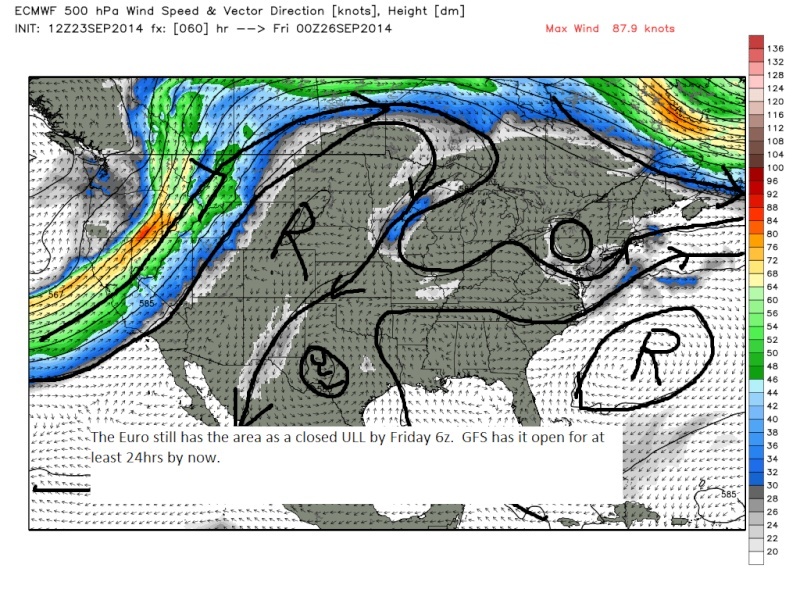 " />
" />As a result of still being closed at 500mb there still is a weak closed surface LP as well still drawing in moisture over LI and SE New England.
 " />
" />GFS00z Friday
 " />
" /> " />
" />So the Key here is if the ULL over the SE CONUS stays closed or not and the timing of that as well. Open vs closed I think depends on how much the shortwave digs and how fast it is. The difference can be seen in the total precip maps. Look at the sharp cutoff in the precip into our area between the two outcomes. IMO this will boil down to observations on water vapor imagery come wed into Thursday. You have to respect the Euro though.
EURO precip
 " />
" />GFS Precip
 " />
" />If this sucker opens up early and the HP builds in from the west fast and furious we could see last minute totals decrease dramatically. Im stoked there is something to analyze.
_________________
"In weather and in life, there's no winning and losing; there's only winning and learning."
WINTER 2012/2013 TOTALS 43.65"WINTER 2017/2018 TOTALS 62.85" WINTER 2022/2023 TOTALS 4.9"
WINTER 2013/2014 TOTALS 64.85"WINTER 2018/2019 TOTALS 14.25" WINTER 2023/2024 TOTALS 13.1"
WINTER 2014/2015 TOTALS 71.20"WINTER 2019/2020 TOTALS 6.35"
WINTER 2015/2016 TOTALS 35.00"WINTER 2020/2021 TOTALS 37.75"
WINTER 2016/2017 TOTALS 42.25"WINTER 2021/2022 TOTALS 31.65"

sroc4- Admin
- Posts : 8331
Reputation : 301
Join date : 2013-01-07
Location : Wading River, LI
Re: Coastal Storm 9/25/14
![]() by Math23x7 Wed Sep 24, 2014 12:32 am
by Math23x7 Wed Sep 24, 2014 12:32 am
Math23x7- Wx Statistician Guru

- Posts : 2379
Reputation : 68
Join date : 2013-01-08
Re: Coastal Storm 9/25/14
![]() by docstox12 Wed Sep 24, 2014 6:42 am
by docstox12 Wed Sep 24, 2014 6:42 am
Math23x7 wrote:Even though I am a Met fan, it would really be a shame if Jeter's final regular season game on Thursday gets rained out. ..
Same here. Met Fan hoping this does not interfere with Derek Jeter's final home game.Hope he goes out blasting a home run or two for the Yankee Fans.

docstox12- Wx Statistician Guru
- Posts : 8502
Reputation : 222
Join date : 2013-01-07
Age : 73
Location : Monroe NY
Re: Coastal Storm 9/25/14
![]() by sroc4 Wed Sep 24, 2014 7:11 am
by sroc4 Wed Sep 24, 2014 7:11 am
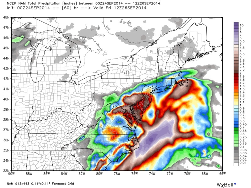
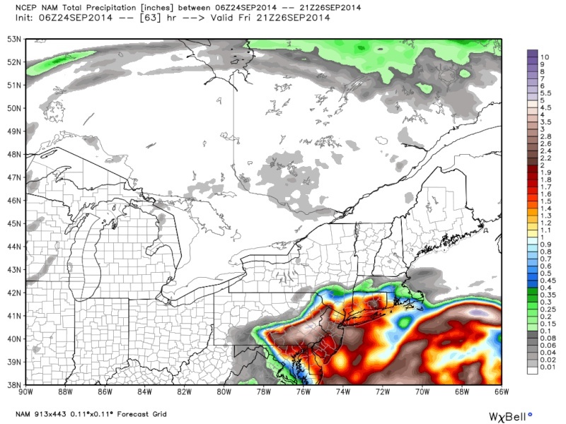
Here are the precip totals 00z 's from last night. 00z EURO esp, came in a bit dryer; Although, 6zz GFS and NAM came in wetter than their 00z. Notice the difference in ideas in the distribution of the precip. The Euro and Nam have a swath of higher totals that extends up through SNJ and into PA and another swath off shore; whereas, the GFS and the CMC have sharp cutoffs to the west leaving the heavier precip at the coastline. I think because there is somewhat of a disconnect between the weak closed 500mb LP and the weak surface LP leaving a void of lesser amts in the middle. It looks like an area of increased vertical velocities combined with high relative humidity over PA will lead to higher totals in these areas as the Euro and NAM are showing. Ill be at the game regardless.
Euro
 " />
" />NAM
 " />
" />GFS
 " />
" />CMC
 " />
" />_________________
"In weather and in life, there's no winning and losing; there's only winning and learning."
WINTER 2012/2013 TOTALS 43.65"WINTER 2017/2018 TOTALS 62.85" WINTER 2022/2023 TOTALS 4.9"
WINTER 2013/2014 TOTALS 64.85"WINTER 2018/2019 TOTALS 14.25" WINTER 2023/2024 TOTALS 13.1"
WINTER 2014/2015 TOTALS 71.20"WINTER 2019/2020 TOTALS 6.35"
WINTER 2015/2016 TOTALS 35.00"WINTER 2020/2021 TOTALS 37.75"
WINTER 2016/2017 TOTALS 42.25"WINTER 2021/2022 TOTALS 31.65"
sroc4- Admin
- Posts : 8331
Reputation : 301
Join date : 2013-01-07
Location : Wading River, LI
Re: Coastal Storm 9/25/14
![]() by amugs Wed Sep 24, 2014 7:28 am
by amugs Wed Sep 24, 2014 7:28 am
The 6Z GFS says so jogged west with precip amounts:

_________________
Mugs
AKA:King: Snow Weenie
Self Proclaimed
WINTER 2014-15 : 55.12" +.02 for 6 coatings (avg. 35")
WINTER 2015-16 Total - 29.8" (Avg 35")
WINTER 2016-17 : 39.5" so far
amugs- Advanced Forecaster - Mod
- Posts : 15093
Reputation : 213
Join date : 2013-01-07
Age : 54
Location : Hillsdale,NJ
Re: Coastal Storm 9/25/14
![]() by sroc4 Wed Sep 24, 2014 8:14 am
by sroc4 Wed Sep 24, 2014 8:14 am
amugs wrote:Scott - Great Analysis but one thing I am hoping for is a good soaking rain for the western parts of the NYC metro area - we need it!!
The 6Z GFS says so jogged west with precip amounts:
As did the NAM. Let it soak early, and be done by say 4pm. Enough time to dry up th field. I may be ambitious here
[img]
 [/img]
Last edited by sroc4 on Wed Sep 24, 2014 8:35 am; edited 1 time in total
_________________
"In weather and in life, there's no winning and losing; there's only winning and learning."
WINTER 2012/2013 TOTALS 43.65"WINTER 2017/2018 TOTALS 62.85" WINTER 2022/2023 TOTALS 4.9"
WINTER 2013/2014 TOTALS 64.85"WINTER 2018/2019 TOTALS 14.25" WINTER 2023/2024 TOTALS 13.1"
WINTER 2014/2015 TOTALS 71.20"WINTER 2019/2020 TOTALS 6.35"
WINTER 2015/2016 TOTALS 35.00"WINTER 2020/2021 TOTALS 37.75"
WINTER 2016/2017 TOTALS 42.25"WINTER 2021/2022 TOTALS 31.65"
sroc4- Admin
- Posts : 8331
Reputation : 301
Join date : 2013-01-07
Location : Wading River, LI
Re: Coastal Storm 9/25/14
![]() by sroc4 Wed Sep 24, 2014 8:15 am
by sroc4 Wed Sep 24, 2014 8:15 am
http://www.erh.noaa.gov/okx/stormtotalprecip.php
_________________
"In weather and in life, there's no winning and losing; there's only winning and learning."
WINTER 2012/2013 TOTALS 43.65"WINTER 2017/2018 TOTALS 62.85" WINTER 2022/2023 TOTALS 4.9"
WINTER 2013/2014 TOTALS 64.85"WINTER 2018/2019 TOTALS 14.25" WINTER 2023/2024 TOTALS 13.1"
WINTER 2014/2015 TOTALS 71.20"WINTER 2019/2020 TOTALS 6.35"
WINTER 2015/2016 TOTALS 35.00"WINTER 2020/2021 TOTALS 37.75"
WINTER 2016/2017 TOTALS 42.25"WINTER 2021/2022 TOTALS 31.65"
sroc4- Admin
- Posts : 8331
Reputation : 301
Join date : 2013-01-07
Location : Wading River, LI
Re: Coastal Storm 9/25/14
![]() by Frank_Wx Wed Sep 24, 2014 8:35 am
by Frank_Wx Wed Sep 24, 2014 8:35 am
_________________
_______________________________________________________________________________________________________
CLICK HERE to view NJ Strong Snowstorm Classifications
Frank_Wx- Godzilla Seeker
- Posts : 21305
Reputation : 328
Join date : 2013-01-05
Age : 31
Location : Jersey City, NJ -
Re: Coastal Storm 9/25/14
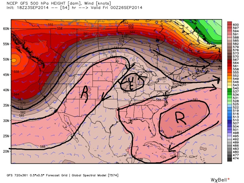
![]() by Frank_Wx Wed Sep 24, 2014 9:57 am
by Frank_Wx Wed Sep 24, 2014 9:57 am

Looking at the upper air pattern, this is why I feel the storm will ultimately take a track following the black line I drew, or even further east than that (I kinda wanted to draw it a little further east). The pattern is fast-paced with a large trough entering the Pac. NW and a rolling ridge coming through the center of the country. Once the storm recognizes the High moving east, its track will get shunned east and dry air may try to eat away at the moisture on the western fringe of the storm.
That being said, .50-1.00 inches of rain look most likely, but not those 2-3+ inch amounts some models were advertising yesterday.
_________________
_______________________________________________________________________________________________________
CLICK HERE to view NJ Strong Snowstorm Classifications
Frank_Wx- Godzilla Seeker
- Posts : 21305
Reputation : 328
Join date : 2013-01-05
Age : 31
Location : Jersey City, NJ -
Re: Coastal Storm 9/25/14
![]() by Dunnzoo Wed Sep 24, 2014 10:28 am
by Dunnzoo Wed Sep 24, 2014 10:28 am
_________________
Janet
Snowfall winter of 2023-2024 17.5"
Snowfall winter of 2022-2023 6.0"
Snowfall winter of 2021-2022 17.6" 1" sleet 2/25/22
Snowfall winter of 2020-2021 51.1"
Snowfall winter of 2019-2020 8.5"
Snowfall winter of 2018-2019 25.1"
Snowfall winter of 2017-2018 51.9"
Snowfall winter of 2016-2017 45.6"
Snowfall winter of 2015-2016 29.5"
Snowfall winter of 2014-2015 50.55"
Snowfall winter of 2013-2014 66.5"
Dunnzoo- Senior Enthusiast - Mod
- Posts : 4884
Reputation : 68
Join date : 2013-01-11
Age : 62
Location : Westwood, NJ
Re: Coastal Storm 9/25/14
![]() by algae888 Wed Sep 24, 2014 10:40 am
by algae888 Wed Sep 24, 2014 10:40 am
algae888- Advanced Forecaster
- Posts : 5311
Reputation : 46
Join date : 2013-02-05
Age : 61
Location : mt. vernon, new york
Page 1 of 3 • 1, 2, 3 ![]()
|
|
|