
 Search
Cut-off Storm 10/15 - 10/16
Page 1 of 2 • 1, 2 ![]()

Cut-off Storm 10/15 - 10/16
![]() by Frank_Wx Mon Oct 13, 2014 5:36 pm
by Frank_Wx Mon Oct 13, 2014 5:36 pm

This is an image from the EURO model at the H5 level showing us what happens when a storm phases earlier than usual. The result is a bowling ball vortex traveling slowly from west to east across the country. Notice the positive heights on both sides of the storm, an essential reason why the phase occurred quickly between the northern and southern branches. This system eventually gets to our area Wednesday evening.

Wind gusts will be highest over Long Island. With a High located off the coast and the low pressure storm approaching the area, they will be stuck in between both air pressures which as a result will give them wind gusts possibly over 40 mph. 25-35 kph elsewhere.

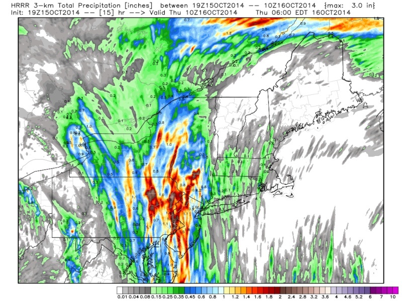
Rain will be mainly moderate, heavy at times. The image above is from the EURO 7am Thursday morning. There's a good chance we see greater than 1.50-2.00 inches of rain. Most of this will depend on if and where convection develops. I'll examine that portion of the storm tomorrow, but I don't think it will be bad. Timing is Wednesday night into Thursday morning.
More details to come through the week.
Last edited by Frank_Wx on Thu Oct 16, 2014 9:00 pm; edited 1 time in total
_________________
_______________________________________________________________________________________________________
CLICK HERE to view NJ Strong Snowstorm Classifications

Frank_Wx- Godzilla Seeker

- Posts : 21305
Reputation : 328
Join date : 2013-01-05
Age : 31
Location : Jersey City, NJ -

Re: Cut-off Storm 10/15 - 10/16
![]() by Frank_Wx Tue Oct 14, 2014 3:47 pm
by Frank_Wx Tue Oct 14, 2014 3:47 pm
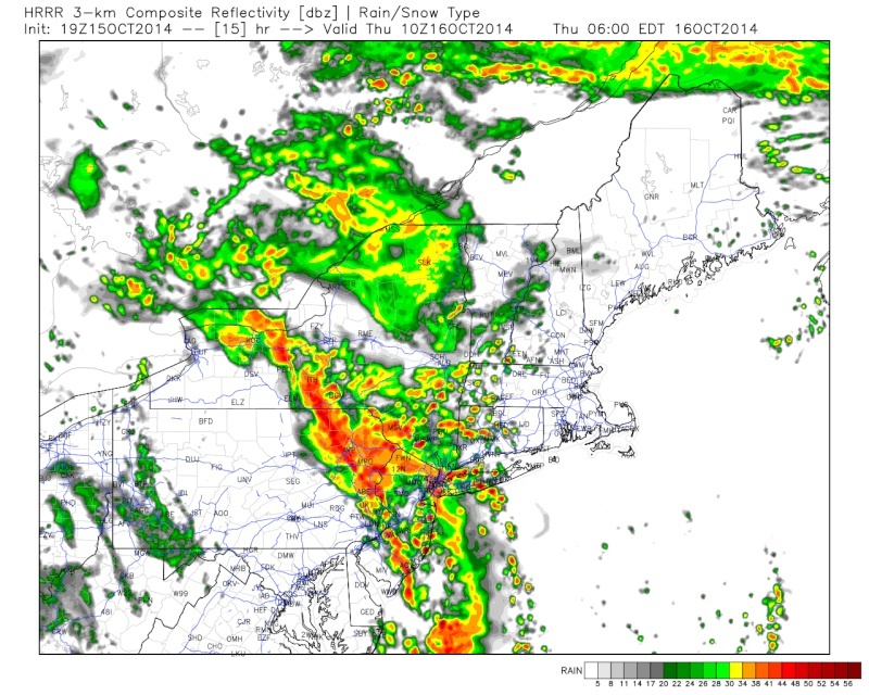
Rain tomorrow will start between 2-4pm and end 9-11am on Thursday. Totals will range between .75-1.25, a slight downgrade from what I thought originally. If your area sees some convection, it's possible you see 1.50+ inches of rain, but generally should see less than that.
Heaviest rain will be during the morning between 6-8am.
Sunny and pleasant conditions expected Friday and Saturday with temps near 70.
Will update the long range later on
_________________
_______________________________________________________________________________________________________
CLICK HERE to view NJ Strong Snowstorm Classifications
Frank_Wx- Godzilla Seeker
- Posts : 21305
Reputation : 328
Join date : 2013-01-05
Age : 31
Location : Jersey City, NJ -
Re: Cut-off Storm 10/15 - 10/16
![]() by Frank_Wx Tue Oct 14, 2014 11:35 pm
by Frank_Wx Tue Oct 14, 2014 11:35 pm

Slow moving storm heading our way. Temps warm ahead of it, cool behind it. 1-2 inches of rain expected.
_________________
_______________________________________________________________________________________________________
CLICK HERE to view NJ Strong Snowstorm Classifications
Frank_Wx- Godzilla Seeker
- Posts : 21305
Reputation : 328
Join date : 2013-01-05
Age : 31
Location : Jersey City, NJ -
Re: Cut-off Storm 10/15 - 10/16
![]() by Frank_Wx Wed Oct 15, 2014 8:57 am
by Frank_Wx Wed Oct 15, 2014 8:57 am

_________________
_______________________________________________________________________________________________________
CLICK HERE to view NJ Strong Snowstorm Classifications
Frank_Wx- Godzilla Seeker
- Posts : 21305
Reputation : 328
Join date : 2013-01-05
Age : 31
Location : Jersey City, NJ -
Re: Cut-off Storm 10/15 - 10/16
![]() by sroc4 Wed Oct 15, 2014 11:20 am
by sroc4 Wed Oct 15, 2014 11:20 am

_________________
"In weather and in life, there's no winning and losing; there's only winning and learning."
WINTER 2012/2013 TOTALS 43.65"WINTER 2017/2018 TOTALS 62.85" WINTER 2022/2023 TOTALS 4.9"
WINTER 2013/2014 TOTALS 64.85"WINTER 2018/2019 TOTALS 14.25" WINTER 2023/2024 TOTALS 13.1"
WINTER 2014/2015 TOTALS 71.20"WINTER 2019/2020 TOTALS 6.35"
WINTER 2015/2016 TOTALS 35.00"WINTER 2020/2021 TOTALS 37.75"
WINTER 2016/2017 TOTALS 42.25"WINTER 2021/2022 TOTALS 31.65"

sroc4- Admin
- Posts : 8331
Reputation : 301
Join date : 2013-01-07
Location : Wading River, LI
Re: Cut-off Storm 10/15 - 10/16
![]() by amugs Wed Oct 15, 2014 11:35 am
by amugs Wed Oct 15, 2014 11:35 am
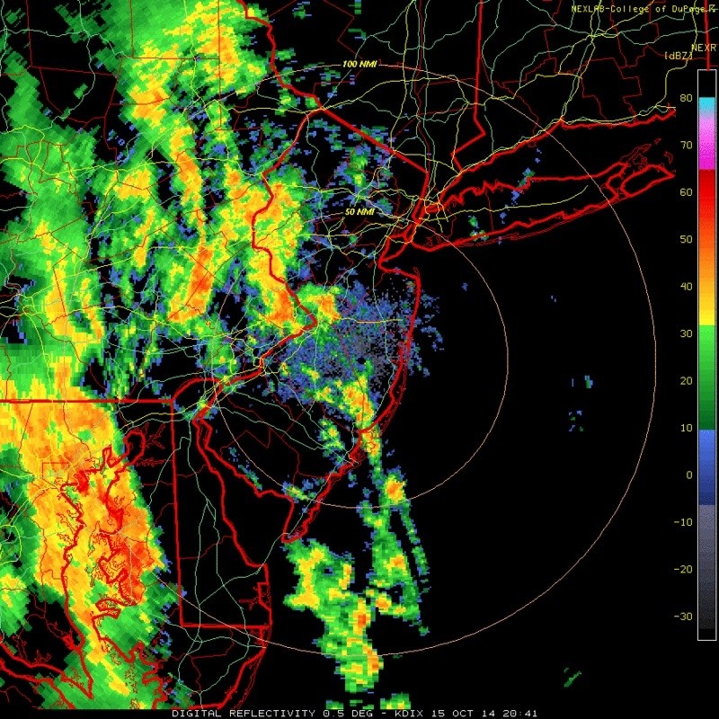
sroc4 wrote:Upton pretty juiced up for LI and immed coast
Upped the amounts from last nights QPF posting - they are seeing training and the convection from the Hcane Gonzalo I guess.
Last edited by amugs on Wed Oct 15, 2014 12:53 pm; edited 1 time in total
_________________
Mugs
AKA:King: Snow Weenie
Self Proclaimed
WINTER 2014-15 : 55.12" +.02 for 6 coatings (avg. 35")
WINTER 2015-16 Total - 29.8" (Avg 35")
WINTER 2016-17 : 39.5" so far

amugs- Advanced Forecaster - Mod

- Posts : 15093
Reputation : 213
Join date : 2013-01-07
Age : 54
Location : Hillsdale,NJ
Re: Cut-off Storm 10/15 - 10/16
![]() by jmanley32 Wed Oct 15, 2014 12:07 pm
by jmanley32 Wed Oct 15, 2014 12:07 pm

jmanley32- Senior Enthusiast

- Posts : 20513
Reputation : 108
Join date : 2013-12-12
Age : 42
Location : Yonkers, NY
Re: Cut-off Storm 10/15 - 10/16
![]() by amugs Wed Oct 15, 2014 12:55 pm
by amugs Wed Oct 15, 2014 12:55 pm
jmanley32 wrote:Ugg thats a lot of rain, going to suck getting into work tomorrow. That line training looks like it could dump a lot and I think winds get a bit up there too, nothing crazy but a front like that. If was really windy yesterday. Yeah the further west gonzalo gets IMO the more moisture will get pulled up, still hasnt made turn to N or NE. Which BTW is now a cat 4 with sustained winds at 135 and pressure 949, wow big boy. Bermuda better be ready.
Holy CRAP - could you imagine if this went as progged last week and the trough pulled it up the coast to us - we would be doomed - I see it is suppose to be a cat 2 (upper end) when it gets near Bermuda - those poor people - nowhere to go except fly out to the states.
_________________
Mugs
AKA:King: Snow Weenie
Self Proclaimed
WINTER 2014-15 : 55.12" +.02 for 6 coatings (avg. 35")
WINTER 2015-16 Total - 29.8" (Avg 35")
WINTER 2016-17 : 39.5" so far
amugs- Advanced Forecaster - Mod
- Posts : 15093
Reputation : 213
Join date : 2013-01-07
Age : 54
Location : Hillsdale,NJ
Re: Cut-off Storm 10/15 - 10/16
![]() by Frank_Wx Wed Oct 15, 2014 1:39 pm
by Frank_Wx Wed Oct 15, 2014 1:39 pm

_________________
_______________________________________________________________________________________________________
CLICK HERE to view NJ Strong Snowstorm Classifications
Frank_Wx- Godzilla Seeker
- Posts : 21305
Reputation : 328
Join date : 2013-01-05
Age : 31
Location : Jersey City, NJ -
Re: Cut-off Storm 10/15 - 10/16
![]() by Quietace Wed Oct 15, 2014 4:40 pm
by Quietace Wed Oct 15, 2014 4:40 pm

Quietace- Meteorologist - Mod

- Posts : 3687
Reputation : 33
Join date : 2013-01-07
Age : 27
Location : Point Pleasant, NJ
Quietace- Meteorologist - Mod
- Posts : 3687
Reputation : 33
Join date : 2013-01-07
Age : 27
Location : Point Pleasant, NJ
Re: Cut-off Storm 10/15 - 10/16
![]() by Quietace Wed Oct 15, 2014 4:43 pm
by Quietace Wed Oct 15, 2014 4:43 pm
Quietace- Meteorologist - Mod
- Posts : 3687
Reputation : 33
Join date : 2013-01-07
Age : 27
Location : Point Pleasant, NJ
Re: Cut-off Storm 10/15 - 10/16
![]() by jmanley32 Wed Oct 15, 2014 4:56 pm
by jmanley32 Wed Oct 15, 2014 4:56 pm
jmanley32- Senior Enthusiast
- Posts : 20513
Reputation : 108
Join date : 2013-12-12
Age : 42
Location : Yonkers, NY
Re: Cut-off Storm 10/15 - 10/16
![]() by jmanley32 Wed Oct 15, 2014 4:58 pm
by jmanley32 Wed Oct 15, 2014 4:58 pm
jmanley32- Senior Enthusiast
- Posts : 20513
Reputation : 108
Join date : 2013-12-12
Age : 42
Location : Yonkers, NY
Re: Cut-off Storm 10/15 - 10/16
![]() by Quietace Wed Oct 15, 2014 5:11 pm
by Quietace Wed Oct 15, 2014 5:11 pm
Gonzalo probably stays between 105-110 knots on its way past Bermuda.jmanley32 wrote:mugs no its supposed to be a cat 3 basically right over Bermuda, strongest and probably worse than Fabian. I really pray for them. Its going to be a rough ride. Frank you are on your game! NWS moved the precip more towards NYC and CT, less than 2 inches west of NYC. But its kind of dicy I would imagine since convection will be hard to pinpoint.
Also true about the convection, isolated areas will certainty pick up more QPF than others in the embedded cells when precipital water values increase over night and into tomorrow.
Quietace- Meteorologist - Mod
- Posts : 3687
Reputation : 33
Join date : 2013-01-07
Age : 27
Location : Point Pleasant, NJ
Re: Cut-off Storm 10/15 - 10/16
![]() by jmanley32 Wed Oct 15, 2014 5:34 pm
by jmanley32 Wed Oct 15, 2014 5:34 pm
jmanley32- Senior Enthusiast
- Posts : 20513
Reputation : 108
Join date : 2013-12-12
Age : 42
Location : Yonkers, NY
Re: Cut-off Storm 10/15 - 10/16
![]() by skinsfan1177 Wed Oct 15, 2014 9:32 pm
by skinsfan1177 Wed Oct 15, 2014 9:32 pm

skinsfan1177- Senior Enthusiast
- Posts : 4485
Reputation : 35
Join date : 2013-01-07
Age : 46
Location : Point Pleasant Boro
Re: Cut-off Storm 10/15 - 10/16
![]() by Frank_Wx Thu Oct 16, 2014 1:40 am
by Frank_Wx Thu Oct 16, 2014 1:40 am

According to NOAAs line graph, rain will end by mid morning or a little before and temps will get to low 70's.
_________________
_______________________________________________________________________________________________________
CLICK HERE to view NJ Strong Snowstorm Classifications
Frank_Wx- Godzilla Seeker
- Posts : 21305
Reputation : 328
Join date : 2013-01-05
Age : 31
Location : Jersey City, NJ -
Re: Cut-off Storm 10/15 - 10/16
![]() by Frank_Wx Thu Oct 16, 2014 8:11 am
by Frank_Wx Thu Oct 16, 2014 8:11 am
_________________
_______________________________________________________________________________________________________
CLICK HERE to view NJ Strong Snowstorm Classifications
Frank_Wx- Godzilla Seeker
- Posts : 21305
Reputation : 328
Join date : 2013-01-05
Age : 31
Location : Jersey City, NJ -
Re: Cut-off Storm 10/15 - 10/16
![]() by Dunnzoo Thu Oct 16, 2014 8:12 am
by Dunnzoo Thu Oct 16, 2014 8:12 am
_________________
Janet
Snowfall winter of 2023-2024 17.5"
Snowfall winter of 2022-2023 6.0"
Snowfall winter of 2021-2022 17.6" 1" sleet 2/25/22
Snowfall winter of 2020-2021 51.1"
Snowfall winter of 2019-2020 8.5"
Snowfall winter of 2018-2019 25.1"
Snowfall winter of 2017-2018 51.9"
Snowfall winter of 2016-2017 45.6"
Snowfall winter of 2015-2016 29.5"
Snowfall winter of 2014-2015 50.55"
Snowfall winter of 2013-2014 66.5"

Dunnzoo- Senior Enthusiast - Mod
- Posts : 4887
Reputation : 68
Join date : 2013-01-11
Age : 62
Location : Westwood, NJ
Re: Cut-off Storm 10/15 - 10/16
![]() by skinsfan1177 Thu Oct 16, 2014 8:14 am
by skinsfan1177 Thu Oct 16, 2014 8:14 am
skinsfan1177- Senior Enthusiast
- Posts : 4485
Reputation : 35
Join date : 2013-01-07
Age : 46
Location : Point Pleasant Boro
Re: Cut-off Storm 10/15 - 10/16
![]() by sroc4 Thu Oct 16, 2014 8:38 am
by sroc4 Thu Oct 16, 2014 8:38 am

_________________
"In weather and in life, there's no winning and losing; there's only winning and learning."
WINTER 2012/2013 TOTALS 43.65"WINTER 2017/2018 TOTALS 62.85" WINTER 2022/2023 TOTALS 4.9"
WINTER 2013/2014 TOTALS 64.85"WINTER 2018/2019 TOTALS 14.25" WINTER 2023/2024 TOTALS 13.1"
WINTER 2014/2015 TOTALS 71.20"WINTER 2019/2020 TOTALS 6.35"
WINTER 2015/2016 TOTALS 35.00"WINTER 2020/2021 TOTALS 37.75"
WINTER 2016/2017 TOTALS 42.25"WINTER 2021/2022 TOTALS 31.65"
sroc4- Admin
- Posts : 8331
Reputation : 301
Join date : 2013-01-07
Location : Wading River, LI
Re: Cut-off Storm 10/15 - 10/16
![]() by algae888 Thu Oct 16, 2014 8:44 am
by algae888 Thu Oct 16, 2014 8:44 am

algae888- Advanced Forecaster

- Posts : 5311
Reputation : 46
Join date : 2013-02-05
Age : 61
Location : mt. vernon, new york
Re: Cut-off Storm 10/15 - 10/16
![]() by amugs Thu Oct 16, 2014 8:47 am
by amugs Thu Oct 16, 2014 8:47 am
_________________
Mugs
AKA:King: Snow Weenie
Self Proclaimed
WINTER 2014-15 : 55.12" +.02 for 6 coatings (avg. 35")
WINTER 2015-16 Total - 29.8" (Avg 35")
WINTER 2016-17 : 39.5" so far
amugs- Advanced Forecaster - Mod
- Posts : 15093
Reputation : 213
Join date : 2013-01-07
Age : 54
Location : Hillsdale,NJ
Re: Cut-off Storm 10/15 - 10/16
![]() by sroc4 Thu Oct 16, 2014 9:24 am
by sroc4 Thu Oct 16, 2014 9:24 am

_________________
"In weather and in life, there's no winning and losing; there's only winning and learning."
WINTER 2012/2013 TOTALS 43.65"WINTER 2017/2018 TOTALS 62.85" WINTER 2022/2023 TOTALS 4.9"
WINTER 2013/2014 TOTALS 64.85"WINTER 2018/2019 TOTALS 14.25" WINTER 2023/2024 TOTALS 13.1"
WINTER 2014/2015 TOTALS 71.20"WINTER 2019/2020 TOTALS 6.35"
WINTER 2015/2016 TOTALS 35.00"WINTER 2020/2021 TOTALS 37.75"
WINTER 2016/2017 TOTALS 42.25"WINTER 2021/2022 TOTALS 31.65"
sroc4- Admin
- Posts : 8331
Reputation : 301
Join date : 2013-01-07
Location : Wading River, LI
Page 1 of 2 • 1, 2 ![]()
|
|
|