
 Search
Official Long Range Thread 4.0
Page 37 of 42 •  1 ... 20 ... 36, 37, 38 ... 42
 ![]()
Re: Official Long Range Thread 4.0
![]() by amugs Sun Dec 07, 2014 10:29 pm
by amugs Sun Dec 07, 2014 10:29 pm
My prediction wintry precip to come area wide Dec 17 - 20 th timeframe sooner than what some might expect by thee maps!
We shall see

amugs- Advanced Forecaster - Mod

- Posts : 15093
Join date : 2013-01-07
Re: Official Long Range Thread 4.0
![]() by Frank_Wx Mon Dec 08, 2014 5:33 pm
by Frank_Wx Mon Dec 08, 2014 5:33 pm

BUT, I really like the look of the 12z Euro Ens today. GOA trough pushing back over the Aleutians. Clear -EPO/+PNA pattern trying to come together by X-mas
Frank_Wx- Godzilla Seeker

- Posts : 21305
Join date : 2013-01-05 -

Re: Official Long Range Thread 4.0
![]() by nutleyblizzard Mon Dec 08, 2014 7:39 pm
by nutleyblizzard Mon Dec 08, 2014 7:39 pm
Looking forward to reading your blog frank. As recently as a week ago I was concerned about our pattern change in jeopardy with the models showing a torch across much of the continental U.S. due to that pesky asian low. Good to see that the low is moving out of the way which will induce stratospheric warming. Once that polar vortex splits, the pattern should lock in and then we'll be in business. The only remaining concern is if we can get good blocking with the cold air. That will be one of the more important ultimate drivers with us getting a normal winter or an epic one. With the El Nino causing these recent overperforming coastals, I'm leaning towards an epic winter.Frank_Wx wrote:I plan on making a blog this weekend to update the long range
BUT, I really like the look of the 12z Euro Ens today. GOA trough pushing back over the Aleutians. Clear -EPO/+PNA pattern trying to come together by X-mas

nutleyblizzard- Senior Enthusiast

- Posts : 1952
Reputation : 41
Join date : 2014-01-30
Age : 58
Location : Nutley, new jersey
Re: Official Long Range Thread 4.0
![]() by sroc4 Mon Dec 08, 2014 8:10 pm
by sroc4 Mon Dec 08, 2014 8:10 pm
Frank_Wx wrote:I plan on making a blog this weekend to update the long range
BUT, I really like the look of the 12z Euro Ens today. GOA trough pushing back over the Aleutians. Clear -EPO/+PNA pattern trying to come together by X-mas
Was planning on doing the same thing tomorrow. GGEM and GFS ens look good as well.
_________________
"In weather and in life, there's no winning and losing; there's only winning and learning."
WINTER 2012/2013 TOTALS 43.65"WINTER 2017/2018 TOTALS 62.85" WINTER 2022/2023 TOTALS 4.9"
WINTER 2013/2014 TOTALS 64.85"WINTER 2018/2019 TOTALS 14.25" WINTER 2023/2024 TOTALS 13.1"
WINTER 2014/2015 TOTALS 71.20"WINTER 2019/2020 TOTALS 6.35"
WINTER 2015/2016 TOTALS 35.00"WINTER 2020/2021 TOTALS 37.75"
WINTER 2016/2017 TOTALS 42.25"WINTER 2021/2022 TOTALS 31.65"

sroc4- Admin
- Posts : 8331
Reputation : 301
Join date : 2013-01-07
Location : Wading River, LI
Re: Official Long Range Thread 4.0
![]() by amugs Mon Dec 08, 2014 8:55 pm
by amugs Mon Dec 08, 2014 8:55 pm
nutleyblizzard wrote:Looking forward to reading your blog frank. As recently as a week ago I was concerned about our pattern change in jeopardy with the models showing a torch across much of the continental U.S. due to that pesky asian low. Good to see that the low is moving out of the way which will induce stratospheric warming. Once that polar vortex splits, the pattern should lock in and then we'll be in business. The only remaining concern is if we can get good blocking with the cold air. That will be one of the more important ultimate drivers with us getting a normal winter or an epic one. With the El Nino causing these recent overperforming coastals, I'm leaning towards an epic winter.Frank_Wx wrote:I plan on making a blog this weekend to update the long range
BUT, I really like the look of the 12z Euro Ens today. GOA trough pushing back over the Aleutians. Clear -EPO/+PNA pattern trying to come together by X-mas
_________________
Mugs
AKA:King: Snow Weenie
Self Proclaimed
WINTER 2014-15 : 55.12" +.02 for 6 coatings (avg. 35")
WINTER 2015-16 Total - 29.8" (Avg 35")
WINTER 2016-17 : 39.5" so far

amugs- Advanced Forecaster - Mod
- Posts : 15093
Reputation : 213
Join date : 2013-01-07
Age : 54
Location : Hillsdale,NJ
Re: Official Long Range Thread 4.0
![]() by amugs Mon Dec 08, 2014 9:35 pm
by amugs Mon Dec 08, 2014 9:35 pm
_________________
Mugs
AKA:King: Snow Weenie
Self Proclaimed
WINTER 2014-15 : 55.12" +.02 for 6 coatings (avg. 35")
WINTER 2015-16 Total - 29.8" (Avg 35")
WINTER 2016-17 : 39.5" so far
amugs- Advanced Forecaster - Mod
- Posts : 15093
Reputation : 213
Join date : 2013-01-07
Age : 54
Location : Hillsdale,NJ
Re: Official Long Range Thread 4.0
![]() by amugs Mon Dec 08, 2014 9:40 pm
by amugs Mon Dec 08, 2014 9:40 pm
_________________
Mugs
AKA:King: Snow Weenie
Self Proclaimed
WINTER 2014-15 : 55.12" +.02 for 6 coatings (avg. 35")
WINTER 2015-16 Total - 29.8" (Avg 35")
WINTER 2016-17 : 39.5" so far
amugs- Advanced Forecaster - Mod
- Posts : 15093
Reputation : 213
Join date : 2013-01-07
Age : 54
Location : Hillsdale,NJ
Re: Official Long Range Thread 4.0
![]() by Math23x7 Mon Dec 08, 2014 9:59 pm
by Math23x7 Mon Dec 08, 2014 9:59 pm
Frank_Wx wrote:I plan on making a blog this weekend to update the long range
BUT, I really like the look of the 12z Euro Ens today. GOA trough pushing back over the Aleutians. Clear -EPO/+PNA pattern trying to come together by X-mas
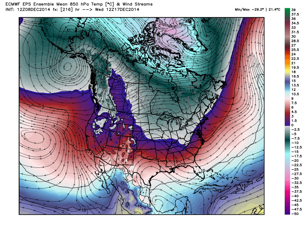
I see the 500 mb heights over northern Quebec and Labrador are much above normal. At a weather conference in 2009, DT mentioned several locations of ridges in the northern latitudes and he said for I-95 corridor, when you see ridging over the aforementioned region, you start doing the snow dance. It sure would be something if this verifies.
Math23x7- Wx Statistician Guru

- Posts : 2379
Reputation : 68
Join date : 2013-01-08
Re: Official Long Range Thread 4.0
![]() by algae888 Tue Dec 09, 2014 5:55 am
by algae888 Tue Dec 09, 2014 5:55 am


hector there is your white xmas...

algae888- Advanced Forecaster

- Posts : 5311
Reputation : 46
Join date : 2013-02-05
Age : 61
Location : mt. vernon, new york
Re: Official Long Range Thread 4.0
![]() by algae888 Tue Dec 09, 2014 8:39 am
by algae888 Tue Dec 09, 2014 8:39 am

algae888- Advanced Forecaster
- Posts : 5311
Reputation : 46
Join date : 2013-02-05
Age : 61
Location : mt. vernon, new york
Re: Official Long Range Thread 4.0
![]() by Snow88 Tue Dec 09, 2014 11:02 am
by Snow88 Tue Dec 09, 2014 11:02 am
Long range is looking a lot better on the Euro and GFS with a parade of storms by Christmas.

Snow88- Senior Enthusiast
- Posts : 2193
Reputation : 4
Join date : 2013-01-09
Age : 35
Location : Brooklyn, NY
Re: Official Long Range Thread 4.0
![]() by Snow88 Tue Dec 09, 2014 12:06 pm
by Snow88 Tue Dec 09, 2014 12:06 pm
Snow88- Senior Enthusiast
- Posts : 2193
Reputation : 4
Join date : 2013-01-09
Age : 35
Location : Brooklyn, NY
Re: Official Long Range Thread 4.0
![]() by amugs Tue Dec 09, 2014 12:57 pm
by amugs Tue Dec 09, 2014 12:57 pm

_________________
Mugs
AKA:King: Snow Weenie
Self Proclaimed
WINTER 2014-15 : 55.12" +.02 for 6 coatings (avg. 35")
WINTER 2015-16 Total - 29.8" (Avg 35")
WINTER 2016-17 : 39.5" so far
amugs- Advanced Forecaster - Mod
- Posts : 15093
Reputation : 213
Join date : 2013-01-07
Age : 54
Location : Hillsdale,NJ
Re: Official Long Range Thread 4.0
![]() by Frank_Wx Tue Dec 09, 2014 11:37 pm
by Frank_Wx Tue Dec 09, 2014 11:37 pm
If your answer is 3, you are correct. Pretty impressive look and goes to show the flux of our pattern right now in the Pacific.
_________________
_______________________________________________________________________________________________________
CLICK HERE to view NJ Strong Snowstorm Classifications

Frank_Wx- Godzilla Seeker
- Posts : 21305
Reputation : 328
Join date : 2013-01-05
Age : 31
Location : Jersey City, NJ -
Re: Official Long Range Thread 4.0
![]() by sroc4 Wed Dec 10, 2014 7:15 am
by sroc4 Wed Dec 10, 2014 7:15 am

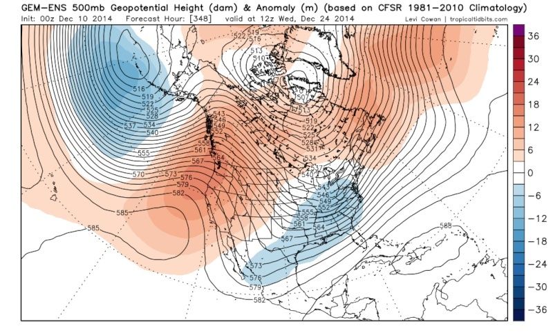
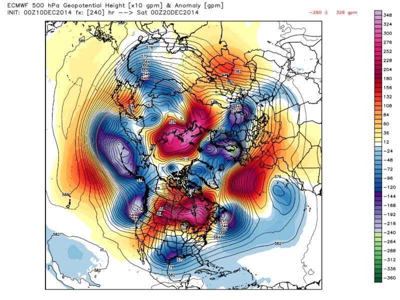
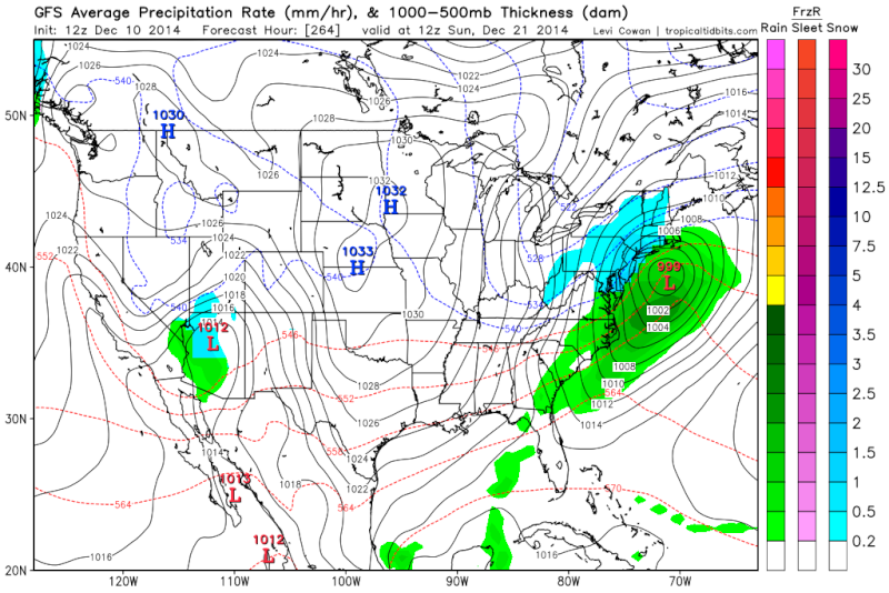
All three ensembles Euro, GFS, Canadian, are still trying to advertise the trough around the Aleutions, ridge coming back in the west, and a trough in the east some time after the 22nd-23rrd Dec 23rd +/- 1-2days. To me that is the time period to watch for the next threat esp for coastal regions as this pattern is much more conducive for a more classic Nor Easter setup. Its the LR so for now we watch.
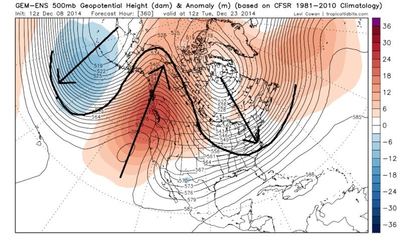
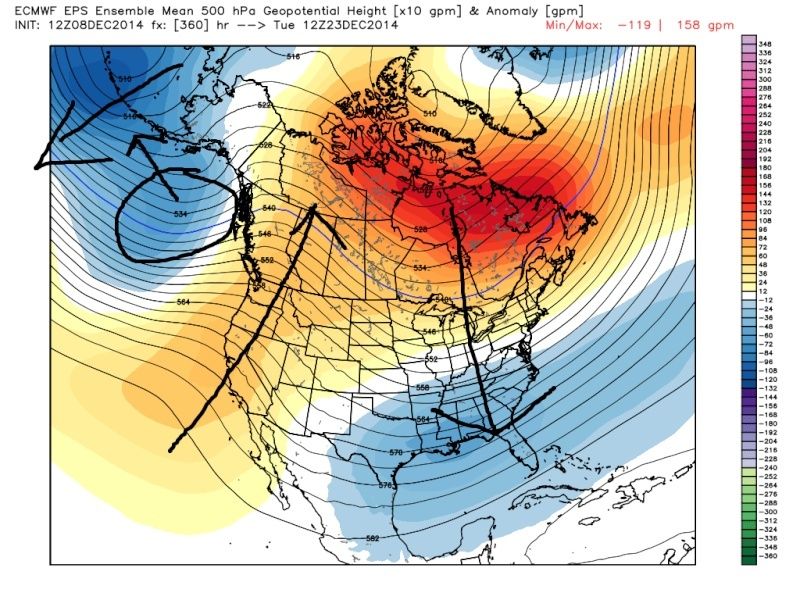
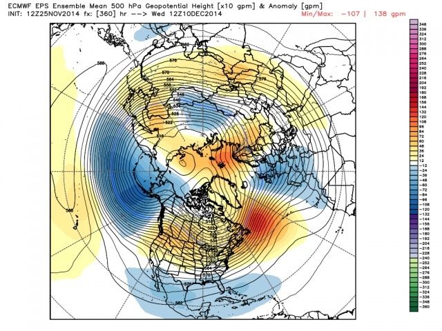
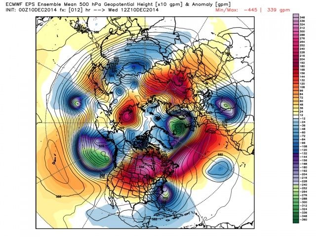
First set of images are the 00z Ens runs from Dec 8th. second set was last nights 00z runs. Remember that these are the ens means meaning that the images are the avg of all the individual members of the model. This far in the long range you are going to get individual members far to the left and far to the right with their individual solns skewing the means. As we get closer we will hopefully see all three lock into what the GGEM seems to be advertising the best as of now.
 " />
" /> " />
" /> " />
" /> " />
" /> " />
" /> " />
" />The next few frames of the Euro ens run from last night breaks down the ridge in the west again but I believe it is because there ae members that try to move the trough near the Aleutions into the GOA too fast skewing the mean. Again we are just going to have to watch how this evolves. Euro operational is hinting at a Miller A type set up at the end of its run. We watch.
_________________
"In weather and in life, there's no winning and losing; there's only winning and learning."
WINTER 2012/2013 TOTALS 43.65"WINTER 2017/2018 TOTALS 62.85" WINTER 2022/2023 TOTALS 4.9"
WINTER 2013/2014 TOTALS 64.85"WINTER 2018/2019 TOTALS 14.25" WINTER 2023/2024 TOTALS 13.1"
WINTER 2014/2015 TOTALS 71.20"WINTER 2019/2020 TOTALS 6.35"
WINTER 2015/2016 TOTALS 35.00"WINTER 2020/2021 TOTALS 37.75"
WINTER 2016/2017 TOTALS 42.25"WINTER 2021/2022 TOTALS 31.65"
sroc4- Admin
- Posts : 8331
Reputation : 301
Join date : 2013-01-07
Location : Wading River, LI
Re: Official Long Range Thread 4.0
![]() by algae888 Wed Dec 10, 2014 8:19 am
by algae888 Wed Dec 10, 2014 8:19 am

cmc

euro
interesting that gfs also has it a day later. we shall see
algae888- Advanced Forecaster
- Posts : 5311
Reputation : 46
Join date : 2013-02-05
Age : 61
Location : mt. vernon, new york
Re: Official Long Range Thread 4.0
![]() by algae888 Wed Dec 10, 2014 8:25 am
by algae888 Wed Dec 10, 2014 8:25 am
algae888- Advanced Forecaster
- Posts : 5311
Reputation : 46
Join date : 2013-02-05
Age : 61
Location : mt. vernon, new york
Re: Official Long Range Thread 4.0
![]() by sroc4 Wed Dec 10, 2014 8:41 am
by sroc4 Wed Dec 10, 2014 8:41 am
algae888 wrote:all models at that time frame have a nice 50/50 block which can keep HP locked in over n/ne and all are consistent with a trough in east. one thing that will not happen is the big warm up in the next 10 days that models and mets were advertising.
Yeah Al the system I mentioned above for the Tuesday-Thursday time frame looks to set up that 50/50 block. Its going to be an interesting next two weeks to see it all evolve. We are going to have to have patience.
 " />
" />Regarding the LR warm up advertised on models well... So far the lack thereof has been the theme. Sure its been milder at times, but nowhere near as advertised in the prev LR runs. Check out JB's blog from this morning: (keep this in mind when reading my post from above on the Euro ens mean)
ECMWF 15 days ago for this morning
 " />
" />Actual:
 " />
" />reaction over the east
 " />
" />_________________
"In weather and in life, there's no winning and losing; there's only winning and learning."
WINTER 2012/2013 TOTALS 43.65"WINTER 2017/2018 TOTALS 62.85" WINTER 2022/2023 TOTALS 4.9"
WINTER 2013/2014 TOTALS 64.85"WINTER 2018/2019 TOTALS 14.25" WINTER 2023/2024 TOTALS 13.1"
WINTER 2014/2015 TOTALS 71.20"WINTER 2019/2020 TOTALS 6.35"
WINTER 2015/2016 TOTALS 35.00"WINTER 2020/2021 TOTALS 37.75"
WINTER 2016/2017 TOTALS 42.25"WINTER 2021/2022 TOTALS 31.65"
sroc4- Admin
- Posts : 8331
Reputation : 301
Join date : 2013-01-07
Location : Wading River, LI
Re: Official Long Range Thread 4.0
![]() by jmanley32 Wed Dec 10, 2014 10:12 am
by jmanley32 Wed Dec 10, 2014 10:12 am

jmanley32- Senior Enthusiast
- Posts : 20517
Reputation : 108
Join date : 2013-12-12
Age : 42
Location : Yonkers, NY
Re: Official Long Range Thread 4.0
![]() by amugs Wed Dec 10, 2014 10:39 am
by amugs Wed Dec 10, 2014 10:39 am
Al- a 50/50 low block would do the trick for a SECS and MECS. Need the - NAO for eh HECS - that will come in January - maybe the anniversary of the great 1996 blizzard.
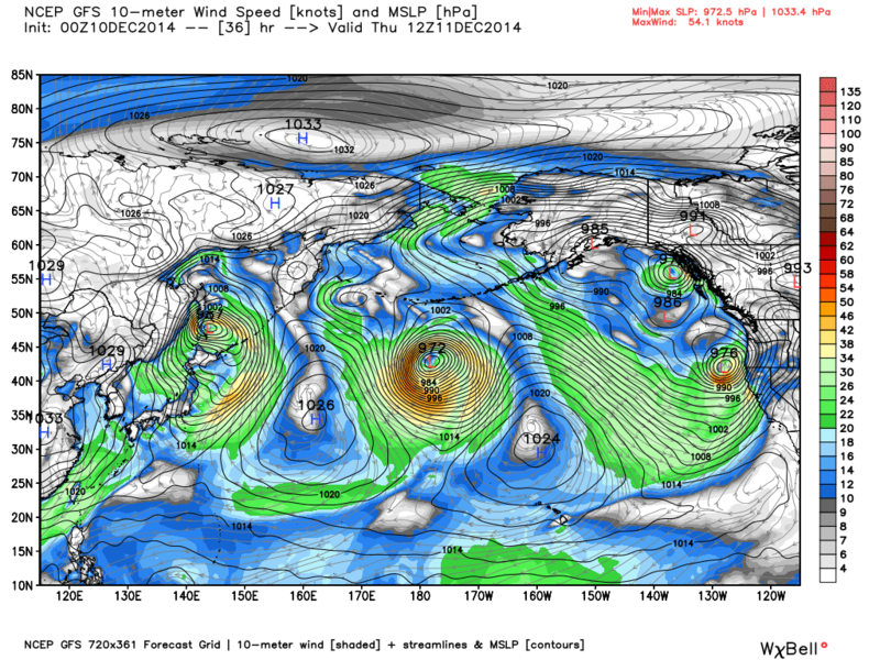
Now for the bold call here - we see a HECS the first week of January +/- 1 or 2 days - why do I say this well I am going to use the BSR (Bearing Seas Rule) as I did for the Thanksgiving Storm. I know Frank is harping on this time frame as well and here is why from my perspective - here is a storm in the Bearing Sea.

The Bering Sea Rule (BSR) states that weather phenomena occurring in the Bering Sea (typically around Shemya, AK) correlates to similar weather phenomena here in the US 17-21 days later. Shemya's rough location is in the red circle in the above map and we see this projected storm system just east of that circle.

The NAO and AO are projected to go negative by this time - so let's see what happens
NAO
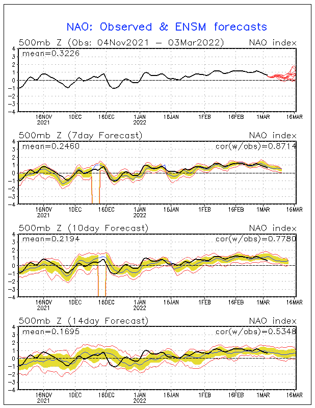
AO
 " />
" />Last edited by amugs on Wed Dec 10, 2014 10:56 am; edited 1 time in total
_________________
Mugs
AKA:King: Snow Weenie
Self Proclaimed
WINTER 2014-15 : 55.12" +.02 for 6 coatings (avg. 35")
WINTER 2015-16 Total - 29.8" (Avg 35")
WINTER 2016-17 : 39.5" so far
amugs- Advanced Forecaster - Mod
- Posts : 15093
Reputation : 213
Join date : 2013-01-07
Age : 54
Location : Hillsdale,NJ
Re: Official Long Range Thread 4.0
![]() by jmanley32 Wed Dec 10, 2014 10:46 am
by jmanley32 Wed Dec 10, 2014 10:46 am
jmanley32- Senior Enthusiast
- Posts : 20517
Reputation : 108
Join date : 2013-12-12
Age : 42
Location : Yonkers, NY
Re: Official Long Range Thread 4.0
![]() by amugs Wed Dec 10, 2014 11:01 am
by amugs Wed Dec 10, 2014 11:01 am
jmanley32 wrote:Ohh come on mugs, now you go have me waiting 20+ days for the possibility of a huge storm lol, lets focus on next weeks potential, at this point a nice 3-6 would be perfect in my book, since we have yet to really see anything lol.
Jman - I am talking SECS if not a both being MECS 6+ area wide not 6" for me and 3" for you HAHAHAHA!!
Teh pattern is a changing and we must be patient to receive the goods my man
_________________
Mugs
AKA:King: Snow Weenie
Self Proclaimed
WINTER 2014-15 : 55.12" +.02 for 6 coatings (avg. 35")
WINTER 2015-16 Total - 29.8" (Avg 35")
WINTER 2016-17 : 39.5" so far
amugs- Advanced Forecaster - Mod
- Posts : 15093
Reputation : 213
Join date : 2013-01-07
Age : 54
Location : Hillsdale,NJ
Re: Official Long Range Thread 4.0
![]() by algae888 Wed Dec 10, 2014 11:11 am
by algae888 Wed Dec 10, 2014 11:11 am
algae888- Advanced Forecaster
- Posts : 5311
Reputation : 46
Join date : 2013-02-05
Age : 61
Location : mt. vernon, new york
Re: Official Long Range Thread 4.0
![]() by jmanley32 Wed Dec 10, 2014 11:46 am
by jmanley32 Wed Dec 10, 2014 11:46 am
jmanley32- Senior Enthusiast
- Posts : 20517
Reputation : 108
Join date : 2013-12-12
Age : 42
Location : Yonkers, NY
Re: Official Long Range Thread 4.0
![]() by jmanley32 Wed Dec 10, 2014 12:31 pm
by jmanley32 Wed Dec 10, 2014 12:31 pm
jmanley32- Senior Enthusiast
- Posts : 20517
Reputation : 108
Join date : 2013-12-12
Age : 42
Location : Yonkers, NY
Re: Official Long Range Thread 4.0
![]() by amugs Wed Dec 10, 2014 12:35 pm
by amugs Wed Dec 10, 2014 12:35 pm
_________________
Mugs
AKA:King: Snow Weenie
Self Proclaimed
WINTER 2014-15 : 55.12" +.02 for 6 coatings (avg. 35")
WINTER 2015-16 Total - 29.8" (Avg 35")
WINTER 2016-17 : 39.5" so far
amugs- Advanced Forecaster - Mod
- Posts : 15093
Reputation : 213
Join date : 2013-01-07
Age : 54
Location : Hillsdale,NJ
Re: Official Long Range Thread 4.0
![]() by jmanley32 Wed Dec 10, 2014 12:41 pm
by jmanley32 Wed Dec 10, 2014 12:41 pm
jmanley32- Senior Enthusiast
- Posts : 20517
Reputation : 108
Join date : 2013-12-12
Age : 42
Location : Yonkers, NY
Page 37 of 42 • 1 ... 20 ... 36, 37, 38 ... 42 ![]()
|
|
|