
 Search
--Oct 6th--pattern change coming
Page 1 of 2 • 1, 2 ![]()

--Oct 6th--pattern change coming
![]() by sroc4 Sun Sep 27, 2015 9:15 am
by sroc4 Sun Sep 27, 2015 9:15 am
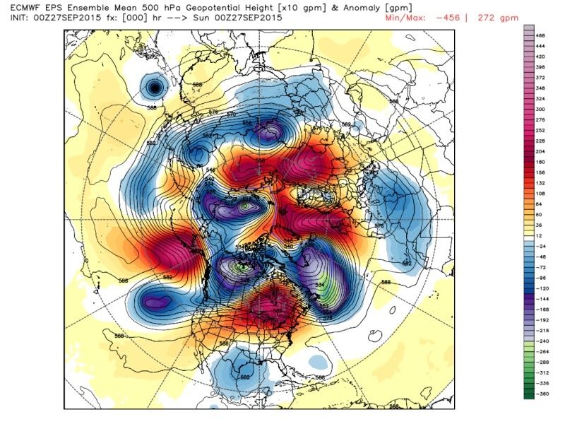
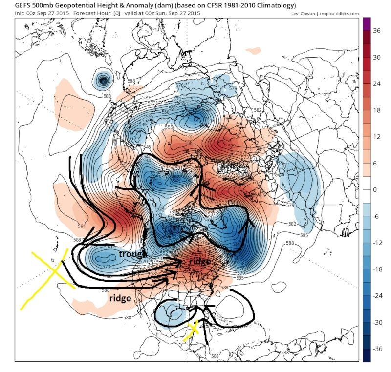
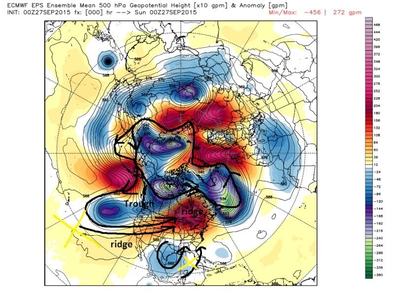
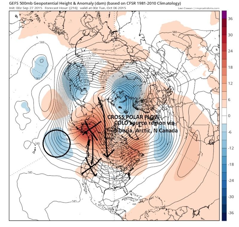
As has been already discussed some in the LR thread change she is a coming. You may have seen some maps of the northern hemisphere (NH) over there and thought..."what the heck am I looking at? And why are they getting so worked up over it. To understand that lets take a look at where the current pattern sits. To illustrate my points I am going to use the GFS ensemble maps(GEFS) and the Euro Ensemble maps(EPS). They are the 500mb(about18,000ft in the atmosphere) anomaly maps. Remember the ensemble maps I am going to show you is the average of all the individual members of that particular model. I believe the GEFS has 25members and the EPS has 51. So that means when looking at the Euro ens map what you see is the avg of all 51 members individual runs. Ok enough of that lets get going.
When viewing these maps keep in mind red colors = ridging = high pressure = clockwise wind direction; whereas, Blue = trough = low pressure = counterclockwise wind direction.
Here are the NH 500mb anomaly maps at time 00 from this evenings 00z runs for both GFS and European ensemble respectively.
 " />
" /> " />
" />Now same maps but Ive drawn in the general wind flow. Take note that the source of the air that is over most if not all of the CONUS originates from the warm waters of the Pacific Ocean as well as the gulf of mexico indicated by the yellow X's. As you can also see the cold air over the arctic is locked up to the north.
 " />
" /> " />
" />Now beginning around the 28th/29th and going through about the 4th/5th a major transition in the pattern is taking place on the models leading to a colder and stormier pattern in the east. The next maps are 00z Oct 6th where the pattern seems to have finished the transition and locks itself in. I believe the most important aspect of this pattern change is in the west. Take particular note of the ridging that develops into Alaska and the trough that backs up south of the Aleutian islands. The two compliment each other. The trough actually aids in pumping the ridge. Again GEFS first followed by the EPS
 " />
" />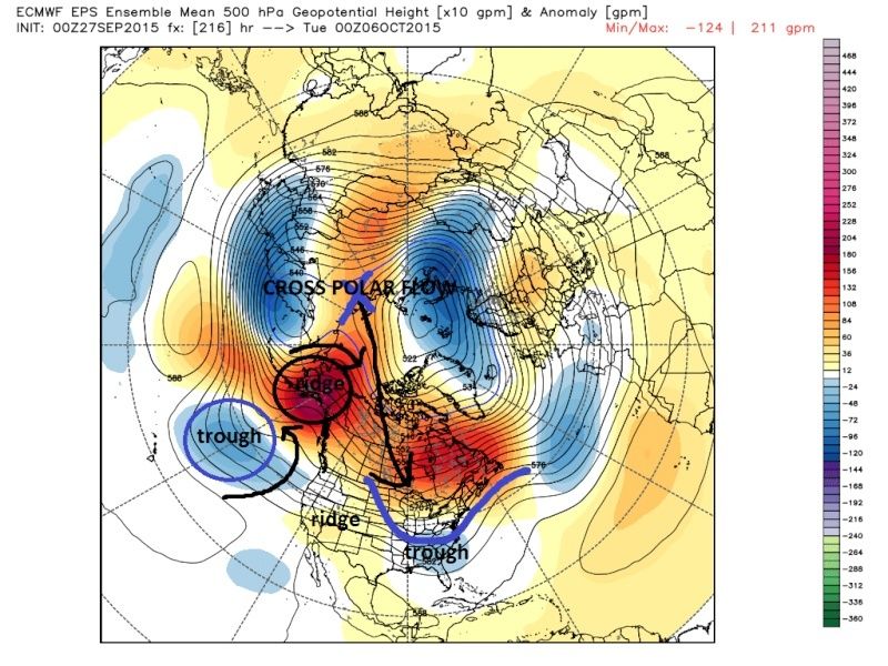 " />
" />This is basically the pattern that has dictated the outcomes of the last two winters. That Alaskan ridge leads to a cross polar flow. What that means is that now instead of the warm pacific as the source region for the air in the east the air now originates in Siberia, crosses over the frozen ice pack that is the arctic (that Mugsy has been showing how rapidly as of late has been expanding), and spilling through Canada into the trough that is in the east. Now keep in mind because of the time of year by the time that air filters into the Lower 48 it will modify, but it will absolutely lead to colder than avg temps for many in the east. If this pattern shows up again this winter expect colder than normal temps and wet(snowy) conditions along the eastern third of the CONUS for sure.
So to reiterate we go from this:
 " />
" /> TO this by Oct 6th:
 " />
" />Now I stress this may change as we approach OCT 6th, but the signal on multiple models and their Ensembles to the ridge up into Alaska should lead to the pattern I described above as we head into Oct. I would expect 1-2 decent storm systems affecting the east coast between Oct4th-8th time frame. The details of where, how much, etc is not important this far out.
With that Happy Football Sunday.
Last edited by sroc4 on Sun Sep 27, 2015 5:49 pm; edited 1 time in total
_________________
"In weather and in life, there's no winning and losing; there's only winning and learning."
WINTER 2012/2013 TOTALS 43.65"WINTER 2017/2018 TOTALS 62.85" WINTER 2022/2023 TOTALS 4.9"
WINTER 2013/2014 TOTALS 64.85"WINTER 2018/2019 TOTALS 14.25" WINTER 2023/2024 TOTALS 13.1"
WINTER 2014/2015 TOTALS 71.20"WINTER 2019/2020 TOTALS 6.35"
WINTER 2015/2016 TOTALS 35.00"WINTER 2020/2021 TOTALS 37.75"
WINTER 2016/2017 TOTALS 42.25"WINTER 2021/2022 TOTALS 31.65"

sroc4- Admin

- Posts : 8354
Reputation : 302
Join date : 2013-01-07
Location : Wading River, LI
Re: --Oct 6th--pattern change coming
![]() by rb924119 Sun Sep 27, 2015 9:58 am
by rb924119 Sun Sep 27, 2015 9:58 am
rb924119- Meteorologist

- Posts : 6928
Reputation : 194
Join date : 2013-02-06
Age : 32
Location : Greentown, Pa
Re: --Oct 6th--pattern change coming
![]() by skinsfan1177 Sun Sep 27, 2015 10:05 am
by skinsfan1177 Sun Sep 27, 2015 10:05 am

skinsfan1177- Senior Enthusiast

- Posts : 4485
Reputation : 35
Join date : 2013-01-07
Age : 46
Location : Point Pleasant Boro
Re: --Oct 6th--pattern change coming
![]() by Guest Sun Sep 27, 2015 11:21 am
by Guest Sun Sep 27, 2015 11:21 am
Guest- Guest
*BLOG* October Pattern Change Leads To More Rain Chances
![]() by Frank_Wx Sun Sep 27, 2015 11:29 am
by Frank_Wx Sun Sep 27, 2015 11:29 am
Please click on the link to read my latest blog regarding the direction our upper air pattern is headed in. We are likely to see increased rain chances in October compared to this month. Also, we should begin feeling more like Fall relatively soon. There is also some El Nino discussion.
http://njstrongweather.blogspot.com/2015/09/expect-complete-360-pattern-change-in.html
Congratulations to the Mets on clinching the NL East. It looks like the Yankees will get in via Wild Card. October baseball in NYC is back!
Best,
Frank
_________________
_______________________________________________________________________________________________________
CLICK HERE to view NJ Strong Snowstorm Classifications

Frank_Wx- Godzilla Seeker
- Posts : 21305
Reputation : 328
Join date : 2013-01-05
Age : 32
Location : Jersey City, NJ -

Re: --Oct 6th--pattern change coming
![]() by docstox12 Sun Sep 27, 2015 1:01 pm
by docstox12 Sun Sep 27, 2015 1:01 pm

docstox12- Wx Statistician Guru

- Posts : 8530
Reputation : 222
Join date : 2013-01-07
Age : 73
Location : Monroe NY
Re: --Oct 6th--pattern change coming
![]() by Dunnzoo Sun Sep 27, 2015 1:07 pm
by Dunnzoo Sun Sep 27, 2015 1:07 pm
_________________
Janet
Snowfall winter of 2023-2024 17.5"
Snowfall winter of 2022-2023 6.0"
Snowfall winter of 2021-2022 17.6" 1" sleet 2/25/22
Snowfall winter of 2020-2021 51.1"
Snowfall winter of 2019-2020 8.5"
Snowfall winter of 2018-2019 25.1"
Snowfall winter of 2017-2018 51.9"
Snowfall winter of 2016-2017 45.6"
Snowfall winter of 2015-2016 29.5"
Snowfall winter of 2014-2015 50.55"
Snowfall winter of 2013-2014 66.5"

Dunnzoo- Senior Enthusiast - Mod

- Posts : 4905
Reputation : 68
Join date : 2013-01-11
Age : 62
Location : Westwood, NJ
Re: --Oct 6th--pattern change coming
![]() by Frank_Wx Sun Sep 27, 2015 4:14 pm
by Frank_Wx Sun Sep 27, 2015 4:14 pm
_________________
_______________________________________________________________________________________________________
CLICK HERE to view NJ Strong Snowstorm Classifications
Frank_Wx- Godzilla Seeker
- Posts : 21305
Reputation : 328
Join date : 2013-01-05
Age : 32
Location : Jersey City, NJ -
Re: --Oct 6th--pattern change coming
![]() by sroc4 Sun Sep 27, 2015 4:50 pm
by sroc4 Sun Sep 27, 2015 4:50 pm
_________________
"In weather and in life, there's no winning and losing; there's only winning and learning."
WINTER 2012/2013 TOTALS 43.65"WINTER 2017/2018 TOTALS 62.85" WINTER 2022/2023 TOTALS 4.9"
WINTER 2013/2014 TOTALS 64.85"WINTER 2018/2019 TOTALS 14.25" WINTER 2023/2024 TOTALS 13.1"
WINTER 2014/2015 TOTALS 71.20"WINTER 2019/2020 TOTALS 6.35"
WINTER 2015/2016 TOTALS 35.00"WINTER 2020/2021 TOTALS 37.75"
WINTER 2016/2017 TOTALS 42.25"WINTER 2021/2022 TOTALS 31.65"
sroc4- Admin
- Posts : 8354
Reputation : 302
Join date : 2013-01-07
Location : Wading River, LI
Re: --Oct 6th--pattern change coming
![]() by Frank_Wx Sun Sep 27, 2015 5:34 pm
by Frank_Wx Sun Sep 27, 2015 5:34 pm
_________________
_______________________________________________________________________________________________________
CLICK HERE to view NJ Strong Snowstorm Classifications
Frank_Wx- Godzilla Seeker
- Posts : 21305
Reputation : 328
Join date : 2013-01-05
Age : 32
Location : Jersey City, NJ -
Re: --Oct 6th--pattern change coming
![]() by Frank_Wx Sun Sep 27, 2015 5:40 pm
by Frank_Wx Sun Sep 27, 2015 5:40 pm
@doc - nice detail to what could be coming. Thanks for taking the time to do the write up and breaking it down in language everyone can understand.
_________________
_______________________________________________________________________________________________________
CLICK HERE to view NJ Strong Snowstorm Classifications
Frank_Wx- Godzilla Seeker
- Posts : 21305
Reputation : 328
Join date : 2013-01-05
Age : 32
Location : Jersey City, NJ -
Re: --Oct 6th--pattern change coming
![]() by sroc4 Sun Sep 27, 2015 5:47 pm
by sroc4 Sun Sep 27, 2015 5:47 pm
_________________
"In weather and in life, there's no winning and losing; there's only winning and learning."
WINTER 2012/2013 TOTALS 43.65"WINTER 2017/2018 TOTALS 62.85" WINTER 2022/2023 TOTALS 4.9"
WINTER 2013/2014 TOTALS 64.85"WINTER 2018/2019 TOTALS 14.25" WINTER 2023/2024 TOTALS 13.1"
WINTER 2014/2015 TOTALS 71.20"WINTER 2019/2020 TOTALS 6.35"
WINTER 2015/2016 TOTALS 35.00"WINTER 2020/2021 TOTALS 37.75"
WINTER 2016/2017 TOTALS 42.25"WINTER 2021/2022 TOTALS 31.65"
sroc4- Admin
- Posts : 8354
Reputation : 302
Join date : 2013-01-07
Location : Wading River, LI
Re: --Oct 6th--pattern change coming
![]() by jmanley32 Sun Sep 27, 2015 6:37 pm
by jmanley32 Sun Sep 27, 2015 6:37 pm

jmanley32- Senior Enthusiast
- Posts : 20535
Reputation : 108
Join date : 2013-12-12
Age : 43
Location : Yonkers, NY
Re: --Oct 6th--pattern change coming
![]() by amugs Sun Sep 27, 2015 8:44 pm
by amugs Sun Sep 27, 2015 8:44 pm
_________________
Mugs
AKA:King: Snow Weenie
Self Proclaimed
WINTER 2014-15 : 55.12" +.02 for 6 coatings (avg. 35")
WINTER 2015-16 Total - 29.8" (Avg 35")
WINTER 2016-17 : 39.5" so far

amugs- Advanced Forecaster - Mod
- Posts : 15095
Reputation : 213
Join date : 2013-01-07
Age : 54
Location : Hillsdale,NJ
Re: --Oct 6th--pattern change coming
![]() by docstox12 Mon Sep 28, 2015 6:31 am
by docstox12 Mon Sep 28, 2015 6:31 am
Hey CP, let the low temperature and snow measurement war in the LHV begin,LOL!
docstox12- Wx Statistician Guru
- Posts : 8530
Reputation : 222
Join date : 2013-01-07
Age : 73
Location : Monroe NY
Re: --Oct 6th--pattern change coming
![]() by rb924119 Mon Sep 28, 2015 12:50 pm
by rb924119 Mon Sep 28, 2015 12:50 pm
rb924119- Meteorologist
- Posts : 6928
Reputation : 194
Join date : 2013-02-06
Age : 32
Location : Greentown, Pa
Re: --Oct 6th--pattern change coming
![]() by jmanley32 Mon Sep 28, 2015 1:01 pm
by jmanley32 Mon Sep 28, 2015 1:01 pm
jmanley32- Senior Enthusiast
- Posts : 20535
Reputation : 108
Join date : 2013-12-12
Age : 43
Location : Yonkers, NY
Re: --Oct 6th--pattern change coming
![]() by jmanley32 Mon Sep 28, 2015 1:08 pm
by jmanley32 Mon Sep 28, 2015 1:08 pm
jmanley32- Senior Enthusiast
- Posts : 20535
Reputation : 108
Join date : 2013-12-12
Age : 43
Location : Yonkers, NY
Re: --Oct 6th--pattern change coming
![]() by sroc4 Mon Sep 28, 2015 1:40 pm
by sroc4 Mon Sep 28, 2015 1:40 pm
rb924119 wrote:Anybody worried about what this pattern resembles from a few Octobers ago? Granted, there are some variations, but it's eerily similar. I think we might REALLY need to pay attention to this, especially for coastal sections. Inland areas will likely see flooding, but I'm very concerned about the coast; they've had sustained onshore fetch for weeks now, add to that this week's deluge and then a tropical system possibly going through an ET as it interacts with the Mid-latitude jet and gets drawn westward toward the coast. This is not good fellas.
I think warm air transport/conveyor belt is going to be a MAJOR player. Busts high and low are possible depending on where you live. I think LI might have a tough time with this.
_________________
"In weather and in life, there's no winning and losing; there's only winning and learning."
WINTER 2012/2013 TOTALS 43.65"WINTER 2017/2018 TOTALS 62.85" WINTER 2022/2023 TOTALS 4.9"
WINTER 2013/2014 TOTALS 64.85"WINTER 2018/2019 TOTALS 14.25" WINTER 2023/2024 TOTALS 13.1"
WINTER 2014/2015 TOTALS 71.20"WINTER 2019/2020 TOTALS 6.35"
WINTER 2015/2016 TOTALS 35.00"WINTER 2020/2021 TOTALS 37.75"
WINTER 2016/2017 TOTALS 42.25"WINTER 2021/2022 TOTALS 31.65"
sroc4- Admin
- Posts : 8354
Reputation : 302
Join date : 2013-01-07
Location : Wading River, LI
Re: --Oct 6th--pattern change coming
![]() by skinsfan1177 Mon Sep 28, 2015 1:52 pm
by skinsfan1177 Mon Sep 28, 2015 1:52 pm
skinsfan1177- Senior Enthusiast
- Posts : 4485
Reputation : 35
Join date : 2013-01-07
Age : 46
Location : Point Pleasant Boro
Re: --Oct 6th--pattern change coming
![]() by jmanley32 Mon Sep 28, 2015 1:55 pm
by jmanley32 Mon Sep 28, 2015 1:55 pm
sroc4 wrote:rb924119 wrote:Anybody worried about what this pattern resembles from a few Octobers ago? Granted, there are some variations, but it's eerily similar. I think we might REALLY need to pay attention to this, especially for coastal sections. Inland areas will likely see flooding, but I'm very concerned about the coast; they've had sustained onshore fetch for weeks now, add to that this week's deluge and then a tropical system possibly going through an ET as it interacts with the Mid-latitude jet and gets drawn westward toward the coast. This is not good fellas.
I think warm air transport/conveyor belt is going to be a MAJOR player. Busts high and low are possible depending on where you live. I think LI might have a tough time with this.
Flooding going be a big issue all over, CMC came in just insane, taking that as a bit high 8-12 inches, from 36-156 hrs. sroc you think NYC area is still possibly in play? I see LI is the main hit area on current projections but once HH come back, which they are out there now and we get a named storm the tracks often change drastically. AND models can have huge changes. Not a lot of time to work with here we should know if a few days.
jmanley32- Senior Enthusiast
- Posts : 20535
Reputation : 108
Join date : 2013-12-12
Age : 43
Location : Yonkers, NY
Re: --Oct 6th--pattern change coming
![]() by jmanley32 Mon Sep 28, 2015 1:56 pm
by jmanley32 Mon Sep 28, 2015 1:56 pm
skinsfan1177 wrote:I have many concerns biggest being the coast this weekend the water was all the way up the beach
Yeah jersey coast def does not need a big storm surge.
jmanley32- Senior Enthusiast
- Posts : 20535
Reputation : 108
Join date : 2013-12-12
Age : 43
Location : Yonkers, NY
Re: --Oct 6th--pattern change coming
![]() by rb924119 Mon Sep 28, 2015 1:56 pm
by rb924119 Mon Sep 28, 2015 1:56 pm
Jman, I am referring to Sandy, but I'm not going to hype this yet. Granted, it has shown up a few times already as a possible solution, but even at this juncture, it is a very delicate setup. I was just doing some fast analysis, and right now, it would appear that a system 10,000 miles away may be the determining factor, and the unfortunate thing is, the way in which it will determine the outcome can only be **parameterized** by models. Instead of being able to take measurements that then go into the millions of calculations and permutations in the models when they run, the data is only assumed to behave in whatever particular way the programmers designed it to within the mathematical core of the model. As was the same with Sandy, the parameterization of the current GFS is allowing it to produce a similar outcome right now. The EURO may be entirely different. The key right now is not to try to figure out whether this could over or under achieve; those possibilities always exist regardless of what the data says, as we saw quite often last winter. The key here is to figure out whether or not the solution, and inherently, the parameterization(s) of the model(s) are leading to plausible outcomes.
To answer your other question, I honestly don't know much of anything about those other models. I've never really used them.
rb924119- Meteorologist
- Posts : 6928
Reputation : 194
Join date : 2013-02-06
Age : 32
Location : Greentown, Pa
Re: --Oct 6th--pattern change coming
![]() by jmanley32 Mon Sep 28, 2015 2:00 pm
by jmanley32 Mon Sep 28, 2015 2:00 pm
jmanley32- Senior Enthusiast
- Posts : 20535
Reputation : 108
Join date : 2013-12-12
Age : 43
Location : Yonkers, NY
Re: --Oct 6th--pattern change coming
![]() by rb924119 Mon Sep 28, 2015 2:02 pm
by rb924119 Mon Sep 28, 2015 2:02 pm
rb924119- Meteorologist
- Posts : 6928
Reputation : 194
Join date : 2013-02-06
Age : 32
Location : Greentown, Pa
Page 1 of 2 • 1, 2 ![]()
|
|
|