
 Search
A Word On the Upcoming Storm Train
+4
Grselig
frank 638
Radz
sroc4
8 posters

A Word On the Upcoming Storm Train
![]() by sroc4 Sun Jan 31, 2016 12:03 pm
by sroc4 Sun Jan 31, 2016 12:03 pm
So just a quick blurb. I am using the euro operational to make my point; however, I am still looking at the ensembles heavily to get the main idea on how things unfold. The main take home point is that after each successive system passes the combination of what happens behind it as well as what happens to the system after it passes to our N and east will dictate how the next one behaves. It looks to me with each successive system passes we get better and better odds at the white gold. Lets begin with the cutter that will bring much warmer than normal temps and rain to our area mid week.
By mid week a strong disturbance in the SW closes off to become an upper level Low (ULL) and cut well to our west. This raises heights along the east coast such that we get the SW flow and the exceptionally warm temps. Once it moves up into Canada it will drag the cold air in behind it.

 " />
" />
Now lets discuss Feb 5th-7th. This is the time frame Mugsy and I are doing epic old school WWF battle over. If he wants to be "Mugs" the animal steel than I will be Hack Saw Jim "the sroc" Duggan

As you can see by Friday we have a trough approaching the east coast; however, notice it in a positively tilted position(SW to NE). Reason being is that we don't have any blocking in the Atlantic, and the ridging to the west of the trough is mediocre at best because the next bit of energy is too close on its heals. The black circle on the left of the screen is the next system.
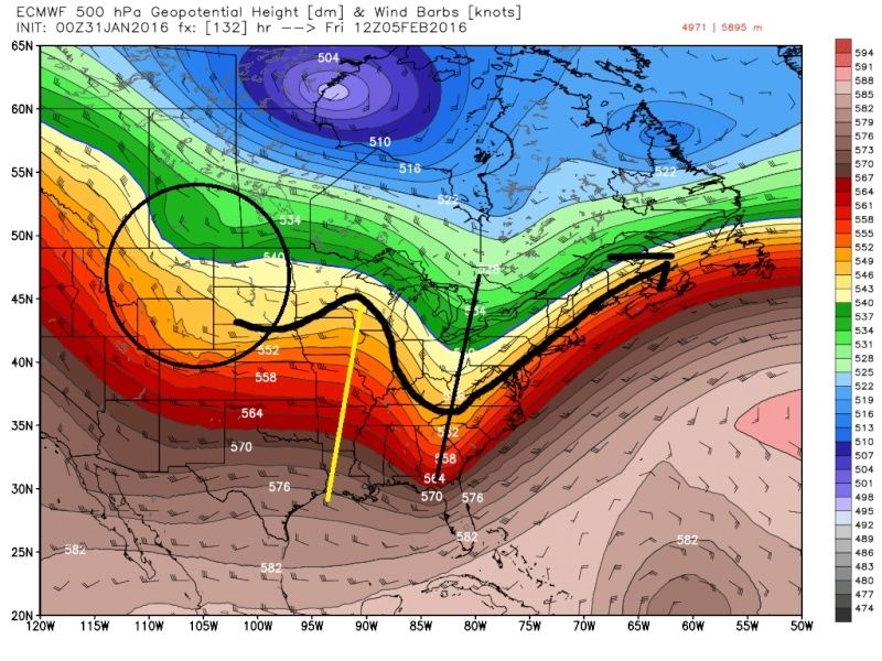 " />
" />
The result of this progressive flow is weak LP developing along the arctic front that the prev cutter dragged through the area with a track well S and E of the BM. I believe at its best the track will remain SE of the BM but room for improvement def exists. I have not given up on snow for our area esp from NYC and points east esp. Approx 12-13 of the Euro ens individual members have snow into our coverage area. Some only a coating to an inch, afew have as much as 4-8" and a few are in between. We would need to see the ridging to the west trend a tad more amped to phase the jets better which ultimately allows the trough to trend more neutral or less positive which would bring LP closer to the BM and a tad stronger, and possibly bring light snow accum to our area. Points east of NYC have a better shot of this. A neg tilted trough with the system is pretty much out of the equation IMO because at this time I don't see the ridge in the west becoming amped enough, mostly because the next system is too close and acts as a kicker, and esp because we don't have any form of blocking to the NE. We will see if trends over the next few days says otherwise. Blocking into the Atlantic looks to be changing with this system however.

Now lets look at the next time frame Feb 7th-10th.
 " />
" />
By Feb seventh the first system is moving out, and the next trough is digging and is headed east. Notice how much better the ridge is to the west and notice the trough axis is centered further west towards the middle of the country. This is important because it allows the trough to come neutral and even neg (as per the euro verbatim) with enough time to bring the LP up the coast instead of progressively OTS. In the wake of the first system we also get a strong HP to the NE that's trys to build in over the top of the surface LP.
 " />
" />
Here is what you get on the surface when the upper level looks like the image above:

The way things look now, in the broadest sense, this has a much better chance to produce than the 5th-7th.
And then finally we have the 10th-13th time frame. This could be the biggest of them all. The Feb 8th system after it moves out acts as a 50/50 LP. It also pups the ridge down stream leading to a neg NAO blocking feauture. The ridge in the west is developing even stronger than the prev. The result if the euro op were to go beyond hr 240 would be a triple phasing system with blocking in the N Atlantic, and exception +PNA, -EPO/-AO blocking.
 " />
" />
Keep in mind the details of any of these systems are FAR FROM KNOWN. DO NOT take the images above as reality; however, please use this discussion to look at the main features for each time frame as we look at the model runs moving forward. With the exception of the cutter mid week (which will cut--duh) and the Feb5th-7th system (which will be either OTS or just SE of the BM), anything from OTS, Perfect BM track, coastal hugger, apps runner, and cutter are all still on the table for all of the remaining systems. Each successive system to pass will influence the next combined with the timing of the features behind them. The MJO influences may play a role with any or all of the systems as well.
IT WILL BE VERY DIFFICULT TO GET THE DETAILS OF ANY OF ONE OF THESE TIME FRAMES BEFORE THE ONE BEFORE IS UPON US AND/OR BEYOND. I CANNOT STRESS THIS POINT ENOUGH. MY POINT WITH THIS IS THAT WE WILL SEE OPERATIONAL MODELS FLIP AND FLOP ALOT IN THE COMING DAYS. THE ENSEMBLE FORECASTS SHOULD GIVE A BETTER IDEA OF WHAT WILL HAPPEN AS TIME MOVES ON. USE THE OPERATIONAL MODELS AND HIGH RES SHORT RANGE MODELS FOR THE SYSTEM IN FRONT OF US AND ENSEMBLE FORECASTS FOR THE ONES BEYOND.
No weenie jumping off the winter cancel bridge either. Cautious optimism will be needed throughout this month. That said...........
Hack Saw Jim "the sroc" Duggan....OUT!!

By mid week a strong disturbance in the SW closes off to become an upper level Low (ULL) and cut well to our west. This raises heights along the east coast such that we get the SW flow and the exceptionally warm temps. Once it moves up into Canada it will drag the cold air in behind it.
" />Now lets discuss Feb 5th-7th. This is the time frame Mugsy and I are doing epic old school WWF battle over. If he wants to be "Mugs" the animal steel than I will be Hack Saw Jim "the sroc" Duggan
As you can see by Friday we have a trough approaching the east coast; however, notice it in a positively tilted position(SW to NE). Reason being is that we don't have any blocking in the Atlantic, and the ridging to the west of the trough is mediocre at best because the next bit of energy is too close on its heals. The black circle on the left of the screen is the next system.
" />The result of this progressive flow is weak LP developing along the arctic front that the prev cutter dragged through the area with a track well S and E of the BM. I believe at its best the track will remain SE of the BM but room for improvement def exists. I have not given up on snow for our area esp from NYC and points east esp. Approx 12-13 of the Euro ens individual members have snow into our coverage area. Some only a coating to an inch, afew have as much as 4-8" and a few are in between. We would need to see the ridging to the west trend a tad more amped to phase the jets better which ultimately allows the trough to trend more neutral or less positive which would bring LP closer to the BM and a tad stronger, and possibly bring light snow accum to our area. Points east of NYC have a better shot of this. A neg tilted trough with the system is pretty much out of the equation IMO because at this time I don't see the ridge in the west becoming amped enough, mostly because the next system is too close and acts as a kicker, and esp because we don't have any form of blocking to the NE. We will see if trends over the next few days says otherwise. Blocking into the Atlantic looks to be changing with this system however.
Now lets look at the next time frame Feb 7th-10th.
" />By Feb seventh the first system is moving out, and the next trough is digging and is headed east. Notice how much better the ridge is to the west and notice the trough axis is centered further west towards the middle of the country. This is important because it allows the trough to come neutral and even neg (as per the euro verbatim) with enough time to bring the LP up the coast instead of progressively OTS. In the wake of the first system we also get a strong HP to the NE that's trys to build in over the top of the surface LP.
" />Here is what you get on the surface when the upper level looks like the image above:
The way things look now, in the broadest sense, this has a much better chance to produce than the 5th-7th.
And then finally we have the 10th-13th time frame. This could be the biggest of them all. The Feb 8th system after it moves out acts as a 50/50 LP. It also pups the ridge down stream leading to a neg NAO blocking feauture. The ridge in the west is developing even stronger than the prev. The result if the euro op were to go beyond hr 240 would be a triple phasing system with blocking in the N Atlantic, and exception +PNA, -EPO/-AO blocking.
" />Keep in mind the details of any of these systems are FAR FROM KNOWN. DO NOT take the images above as reality; however, please use this discussion to look at the main features for each time frame as we look at the model runs moving forward. With the exception of the cutter mid week (which will cut--duh) and the Feb5th-7th system (which will be either OTS or just SE of the BM), anything from OTS, Perfect BM track, coastal hugger, apps runner, and cutter are all still on the table for all of the remaining systems. Each successive system to pass will influence the next combined with the timing of the features behind them. The MJO influences may play a role with any or all of the systems as well.
IT WILL BE VERY DIFFICULT TO GET THE DETAILS OF ANY OF ONE OF THESE TIME FRAMES BEFORE THE ONE BEFORE IS UPON US AND/OR BEYOND. I CANNOT STRESS THIS POINT ENOUGH. MY POINT WITH THIS IS THAT WE WILL SEE OPERATIONAL MODELS FLIP AND FLOP ALOT IN THE COMING DAYS. THE ENSEMBLE FORECASTS SHOULD GIVE A BETTER IDEA OF WHAT WILL HAPPEN AS TIME MOVES ON. USE THE OPERATIONAL MODELS AND HIGH RES SHORT RANGE MODELS FOR THE SYSTEM IN FRONT OF US AND ENSEMBLE FORECASTS FOR THE ONES BEYOND.
No weenie jumping off the winter cancel bridge either. Cautious optimism will be needed throughout this month. That said...........
Hack Saw Jim "the sroc" Duggan....OUT!!
_________________
"In weather and in life, there's no winning and losing; there's only winning and learning."
WINTER 2012/2013 TOTALS 43.65"WINTER 2017/2018 TOTALS 62.85" WINTER 2022/2023 TOTALS 4.9"
WINTER 2013/2014 TOTALS 64.85"WINTER 2018/2019 TOTALS 14.25" WINTER 2023/2024 TOTALS 13.1"
WINTER 2014/2015 TOTALS 71.20"WINTER 2019/2020 TOTALS 6.35"
WINTER 2015/2016 TOTALS 35.00"WINTER 2020/2021 TOTALS 37.75"
WINTER 2016/2017 TOTALS 42.25"WINTER 2021/2022 TOTALS 31.65"

sroc4- Admin

- Posts : 8331
Reputation : 301
Join date : 2013-01-07
Location : Wading River, LI
Re: A Word On the Upcoming Storm Train
![]() by Radz Sun Jan 31, 2016 12:51 pm
by Radz Sun Jan 31, 2016 12:51 pm
Another great analysis! Lots of potential! Thanks for taking the time to spell it all out!

Radz- Pro Enthusiast

- Posts : 1028
Reputation : 17
Join date : 2013-01-12
Location : Cortlandt Manor NY
Re: A Word On the Upcoming Storm Train
![]() by frank 638 Sun Jan 31, 2016 1:06 pm
by frank 638 Sun Jan 31, 2016 1:06 pm
Excellent post I think this Feb Will be the same as last year but I don't think it will be that cold as last year thank you radZ for the write u did looks very interesting in the coming weeks winter is not over yet bring on the Godzilla and rodzilla
frank 638- Senior Enthusiast

- Posts : 2824
Reputation : 37
Join date : 2016-01-01
Age : 40
Location : bronx ny
Re: A Word On the Upcoming Storm Train
![]() by Radz Sun Jan 31, 2016 1:12 pm
by Radz Sun Jan 31, 2016 1:12 pm
frank 638 wrote:Excellent post I think this Feb Will be the same as last year but I don't think it will be that cold as last year thank you radZ for the write u did looks very interesting in the coming weeks winter is not over yet bring on the Godzilla and rodzilla
Thank Sroc!!! (we knew thats what you meant!)
Radz- Pro Enthusiast
- Posts : 1028
Reputation : 17
Join date : 2013-01-12
Location : Cortlandt Manor NY
Re: A Word On the Upcoming Storm Train
![]() by frank 638 Sun Jan 31, 2016 1:34 pm
by frank 638 Sun Jan 31, 2016 1:34 pm
Sorry I meant sroc I got excited to see what's coming for Feb
frank 638- Senior Enthusiast
- Posts : 2824
Reputation : 37
Join date : 2016-01-01
Age : 40
Location : bronx ny
Re: A Word On the Upcoming Storm Train
![]() by sroc4 Sun Jan 31, 2016 1:38 pm
by sroc4 Sun Jan 31, 2016 1:38 pm
Lol. You guys are welcome.
_________________
"In weather and in life, there's no winning and losing; there's only winning and learning."
WINTER 2012/2013 TOTALS 43.65"WINTER 2017/2018 TOTALS 62.85" WINTER 2022/2023 TOTALS 4.9"
WINTER 2013/2014 TOTALS 64.85"WINTER 2018/2019 TOTALS 14.25" WINTER 2023/2024 TOTALS 13.1"
WINTER 2014/2015 TOTALS 71.20"WINTER 2019/2020 TOTALS 6.35"
WINTER 2015/2016 TOTALS 35.00"WINTER 2020/2021 TOTALS 37.75"
WINTER 2016/2017 TOTALS 42.25"WINTER 2021/2022 TOTALS 31.65"
sroc4- Admin
- Posts : 8331
Reputation : 301
Join date : 2013-01-07
Location : Wading River, LI
Re: A Word On the Upcoming Storm Train
![]() by Grselig Sun Jan 31, 2016 2:30 pm
by Grselig Sun Jan 31, 2016 2:30 pm
Great write up Superstar Billy SROC. The latest and greatest, meanest bohemianist. The Champion of the Free World, best dressed and fighter for the oppressed. Back in the day, you crushed the Iron Sheik.

Grselig- Senior Enthusiast
- Posts : 1408
Reputation : 140
Join date : 2013-03-04
Age : 54
Location : Wayne NJ
Re: A Word On the Upcoming Storm Train
![]() by roccuweather Sun Jan 31, 2016 3:11 pm
by roccuweather Sun Jan 31, 2016 3:11 pm
For the record...Ravishing Roccuweather Rude sides with SRoc Duggan on this one.


roccuweather- Posts : 37
Reputation : 0
Join date : 2014-03-01
Location : Bradley Beach, NJ
Re: A Word On the Upcoming Storm Train
![]() by Guest Sun Jan 31, 2016 4:24 pm
by Guest Sun Jan 31, 2016 4:24 pm
Great write up sroc. My wife wants you all to know that with all the pictures of topless wrestlers she's beginning to "wonder" what time per of people I'm actually associating with on thi site and what the actual purpose of the forum is!!!!!!,
Guest- Guest
Re: A Word On the Upcoming Storm Train
![]() by amugs Sun Jan 31, 2016 5:53 pm
by amugs Sun Jan 31, 2016 5:53 pm
Great write up SROC even coming FROM Mugs the Animal Steel!! LOTS of TRACKING and potential ahead.
_________________
Mugs
AKA:King: Snow Weenie
Self Proclaimed
WINTER 2014-15 : 55.12" +.02 for 6 coatings (avg. 35")
WINTER 2015-16 Total - 29.8" (Avg 35")
WINTER 2016-17 : 39.5" so far

amugs- Advanced Forecaster - Mod

- Posts : 15093
Reputation : 213
Join date : 2013-01-07
Age : 54
Location : Hillsdale,NJ
Barroo78- Posts : 3
Reputation : 0
Join date : 2014-02-02
Re: A Word On the Upcoming Storm Train
![]() by Frank_Wx Sun Jan 31, 2016 10:48 pm
by Frank_Wx Sun Jan 31, 2016 10:48 pm
I think the baroclinic zone has a chance to be favorably positioned for all our storm threats this month, aside from the Wednesday cutter of course. There are a couple of keys to February:
1. Will the SE / Atlantic ridges be muted enough to prevent southern short waves from cutting off or tracking to our west. The -EPO should allow phasing to occur at locations that benefit the coast.
2. Will we see west-based Atlantic blocking develop at all. Last time we got Trop Forcing we saw a pretty vigorous -NAO develop around early to mid January. Then once it began to make the switch from negative to positive we got our Roodzilla. This leads me to believe another big dog type storm is waiting for us the middle to end of this month.
I think this is the type of pattern - with all these upper energies roaming the country - that models will not latch onto a storm threat until they're within 4-5 days. Nonetheless, I enjoyed this writeup since it looked at all the players on the field and each possible storm thread through the 2nd week of February.
_________________
_______________________________________________________________________________________________________
CLICK HERE to view NJ Strong Snowstorm Classifications

Frank_Wx- Godzilla Seeker
- Posts : 21305
Reputation : 328
Join date : 2013-01-05
Age : 31
Location : Jersey City, NJ -

Permissions in this forum:
You cannot reply to topics in this forum|
|
|