
 Search
Long Range Thread 11.0
Page 25 of 27 •  1 ... 14 ... 24, 25, 26, 27
 ![]()
Re: Long Range Thread 11.0
![]() by algae888 Sat Jul 09, 2016 2:00 pm
by algae888 Sat Jul 09, 2016 2:00 pm
algae888- Advanced Forecaster

- Posts : 5311
Join date : 2013-02-05
Re: Long Range Thread 11.0
![]() by nutleyblizzard Sat Jul 09, 2016 7:58 pm
by nutleyblizzard Sat Jul 09, 2016 7:58 pm
nutleyblizzard- Senior Enthusiast

- Posts : 1952
Join date : 2014-01-30
Re: Long Range Thread 11.0
![]() by amugs Sat Jul 09, 2016 8:19 pm
by amugs Sat Jul 09, 2016 8:19 pm
Region 3.4 and 4 are still in a Nino state and IF this were to continue through July woudl make it 15 straight months of Nino atmospheric conditions, even though Sept through Nov acted like a Nina state butt hat was due to the Indian Ocean and its abnormal warmth and the Walker Cell set up - SROC explain this in detail in the recap of what went wrong with this past winter. How will teh jet stream set up? Will we FINALLY get some High Latitude Blocking? Will we have a predominately N EPO and will teh AO be N in the means due to the factors of the above normal warmth in the PDO region and the west based Nina? There is a TOOONNNNNNN of time to go and I know one things is for sure is that Joe B will be on this in th eenxt few weeks and I bet just my wise hunch that he will say cold in the NE and MA with bitter cold in the Upper Mid West and above normal snows for these regions. Another challenging forecast up ahead but as many here know we arew up for such challenges.
With low to no soalr suns popts and activities called Solar Minimum how will this play into the deck since teh QBO will be a reverse of where it has been Positive for a change (last time was...??)
Region 3.4 Nada state
Region 4 - Weak Nino

PDO holding on

This from Bob Henson of Wunderground off of Dr Jeff Masters Blog - interesting article
One player now approaching is a strong convectively coupled Kelvin wave (CCKW) located near the International Date Line. CCKWs are large but subtle atmospheric impulses, centered on the equator, that roll eastward at 30-40 mph, with showers and thunderstorms typically along their forward flank. When an eastward-moving CCKW encounters a tropical wave in the Atlantic, the enhanced moisture and upward motion may give it a boost and help it consolidate into a tropical cyclone. For more background on CCKWs, see our post from last July, “Danny’s Leg Up: A Convectively Coupled Kelvin Wave.”
Figure 1. Schematic cross section through a convectively coupled Kelvin wave (CCKW). Image credit: Michael Ventrice.
A CCKW worth watching
The CCKW now in the central Pacific is the strongest that expert Michael Ventrice (The Weather Company) has seen in almost a decade of researching these waves. While passing through the Indian Ocean in mid-June, this CCKW produced near-equatorial westerlies of up to 30 knots (35 mph). This CCKW will be moving into the far eastern Pacific over the next few days. Although Ventrice doubts that this CCKW will maintain its strength as it moves into this area, it still could enhance the odds of tropical cyclone development in the eastern Pacific into the first week of July, as noted in a NOAA discussion on Monday. WU member Levi Cowan (tropicaltidbits.com) observed on Monday that long-range GFS ensemble runs have been unusually consistent in developing a strong tropical cyclone during the first week of July southwest of Mexico. The 8 AM EDT Tuesday tropical weather outlook from the National Hurricane Center gives an area of disturbed weather now along the west coast of Costa Rica a 30% chance of gradual development by next Sunday, July 3, as it moves into the eastern North Pacific well south of Mexico.
The CCKW’s influence may also extend northward to favor development in the Bay of Campeche and/or western Gulf of Mexico. Last week, a few ensemble members from long-range GEFS runs flagged this area for possible development in early July, but the location and strength of the potential tropical cyclone varied greatly from run to run and across ensemble members. The “ghost storm” has since disappeared from more recent GFS runs. (In a Facebook post last Thursday, the NWS office in Tallahassee pointed out the hazard of fixating on a single long-range solution from an ensemble.)
Figure 2. Predicted state of the Madden-Julian Oscillation through mid-July (top to bottom), with the tropical Indian Ocean at left and the eastern tropical Atlantic at right. Bluish colors denote an active phase, favoring showers and thunderstorms (convection) and tropical cyclone formation; red colors show a tendency for convection to be suppressed. The graphics are based on recent conditions (top panel), ECMWF ensemble forecasts (second and third panels), and extrapolation (fourth panel). Image credit: Michael Ventrice, The Weather Company.
Another traveling feature that can influence the Atlantic is the Madden-Julian Oscillation. Typically stronger and much slower-moving than a CCKW, an active MJO phase can favor upward motion and tropical cyclone development for a week or two as its forward flank approaches an ocean basin. MJOs can reinforce or dampen the effects of a CCKW. Ventrice notes: “Usually, the MJO will act to enhance the higher-frequency waves traveling through it. So you will get stronger CCKWs within the active envelope of the MJO and vice versa.” As of last week, the nearest active MJO phase was located over the Maritime Continent, a location that typically works against tropical cyclone development in the western part of the Atlantic basin. It will be a couple of weeks until this MJO makes it far enough east to boost conditions in the Gulf of Mexico, and its strength at that point is still uncertain (see Figure 2). Hurricanes in the Gulf of Mexico and western Caribbean are several times more likely to form during an active MJO phase as opposed to a suppressed phase.
Looking further ahead, the smart money remains on La Niña arriving by autumn, just in time to serve as a favorable influence for tropical cyclones in the Atlantic. Sea surface temperatures in the eastern equatorial Pacific, as tracked by the Niño3.4 index, plummeted from strong El Niño territory in March (departures from normal of greater than +1.5°C) to slightly below-average values in early June, which prompted NOAA to declare an end to the 2015-16 El Niño event. The shift toward La Niña should lead to reduced vertical wind shear over the Atlantic, thus favoring a greater amount of tropical cyclone development.
Figure 3. Departures from the seasonal average of sea surface height (SSH) as measured by NASA satellites on June 8, 1998, and June 9, 2016. Red and white areas denote higher-than-average SSH, which corresponds to warmer-than-average water in the uppermost part of the ocean. Although the El Niño events of 1997-98 and 2015-16 were roughly comparable in timing and strength, the transition toward La Niña was much more advanced at this point in 1998 in terms of cooler-than-average water along the equatorial Pacific. Image credit: NASA/JPL/Caltech.
Figure 4. Departures from the seasonal norm for sea surface temperatures in the Niño3.4 region of the eastern tropical Pacific for April-June 2016. The decrease in SSTs this spring has been marked by large variability, especially in June. Image credit: tropicaltidbits.com.
Is La Niña having second thoughts?
The ongoing transition toward an expected La Niña has been a bit quirky this month. In response to a Western Hemisphere MJO passage, trade winds in early June were unusually weak over much of the eastern tropical Pacific, which runs counter to the La Niña mold. Moreover, the region of cooler-than-average SSTs along the equator is very weak and narrow compared to this point in 1998, when the last “super” El Niño transitioned to La Niña (see Figure 3). The latest weekly Niño3.4 value is -0.4°C, compared to -1.1°C at the same point in June 1998. Another oddity: the daily values of Niño3.4 spiked back above +0.5°C for nearly a week in mid-June, then sank back into negative territory in a matter of days (see Figure 4).
This last quirk may be related to a picturesque feature called tropical instability waves, or TIW. These waves often develop across the eastern equatorial Pacific in northern summer and fall, especially during the onset of La Niña, when SST contrasts are heightened between the equatorial and subtropical regions. The sharp contrast, together with shear produced by contrasting ocean currents, can lead to a line of eddy-like features straddling the equator and marching westward, with a typical separation of about 700 miles (1100 km) between each wave (see Figure 5). Overall, TIW can have a dampening effect on La Niña events, as confirmed in a high-resolution modeling study led by Yukiko Imade (University of Tokyo). In addition, Ventrice notes that the TAO/TRITON buoys that monitor SST across the tropical Pacific have an east-to-west spacing of 15° of longitude, or about 1000 miles (1600 km). According to Ventrice, the wavelength of the TIW and the buoy spacing can sometimes be similar enough to allow regional SST reports to rise and fall in unison over very short periods when the TIW are especially active, as was the case this month (see Figure 6).
Figure 5. Departures from the seasonal average in SSTs across the eastern Pacific at 18Z Friday, June 24, 2016, reveal a sequence of tropical instability waves (TIW) straddling the equator. Image credit: earth.nullschool.net.
Figure 6. For the 7-day period from 12Z June 17, 2016, to 12Z June 24, sea surface temperatures rose and fell in a distinct wavelike pattern across the eastern tropical Pacific, showing the influence of tropical instability waves. Image credit: tropicaltidbits.com.
The bottom line
Despite its unorthodox entrance cues, La Niña is very likely still on its way. One strong sign: just below the surface of the equatorial Pacific, there is still a large area of cooler-than-normal water dominating the topmost 200 meters (660 feet). Any downwelling at the surface would more likely postpone or weaken an impending La Niña rather than quash it. Moreover, an impressive surge of trade winds now across the central/eastern Pacific is expected to force a period of enhanced upwelling in the eastern Pacific that’s likely to boost the evolving La Nina event, according to Ventrice.
Me:
The Cold water is near the surface or what is called teh sub surface of teh ocean in the eastern sections but stiull holding on in the western or 3.4 and 4 regions of ENSO - equatorial regions.
Interesting times ahead here peeps.
_________________
Mugs
AKA:King: Snow Weenie
Self Proclaimed
WINTER 2014-15 : 55.12" +.02 for 6 coatings (avg. 35")
WINTER 2015-16 Total - 29.8" (Avg 35")
WINTER 2016-17 : 39.5" so far

amugs- Advanced Forecaster - Mod

- Posts : 15093
Reputation : 213
Join date : 2013-01-07
Age : 54
Location : Hillsdale,NJ
Re: Long Range Thread 11.0
![]() by amugs Sat Jul 09, 2016 9:57 pm
by amugs Sat Jul 09, 2016 9:57 pm
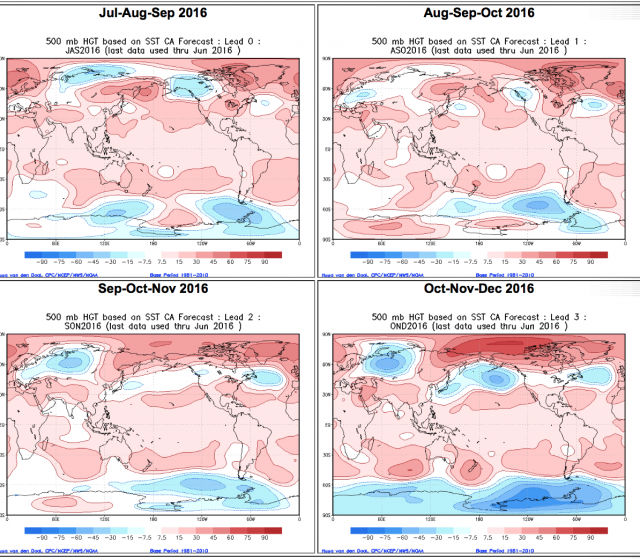
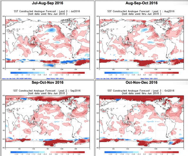
SST OND leading to winter - Nina - NOT!!

DOH!! Look a the temps - it says we bake BUTG not so fast..........

to this with a cold IO and warm PDO???? How does this happen not sure IMHO
.png)
500mb set up like this too?
_________________
Mugs
AKA:King: Snow Weenie
Self Proclaimed
WINTER 2014-15 : 55.12" +.02 for 6 coatings (avg. 35")
WINTER 2015-16 Total - 29.8" (Avg 35")
WINTER 2016-17 : 39.5" so far
amugs- Advanced Forecaster - Mod
- Posts : 15093
Reputation : 213
Join date : 2013-01-07
Age : 54
Location : Hillsdale,NJ
Re: Long Range Thread 11.0
![]() by amugs Sat Jul 09, 2016 10:00 pm
by amugs Sat Jul 09, 2016 10:00 pm
_________________
Mugs
AKA:King: Snow Weenie
Self Proclaimed
WINTER 2014-15 : 55.12" +.02 for 6 coatings (avg. 35")
WINTER 2015-16 Total - 29.8" (Avg 35")
WINTER 2016-17 : 39.5" so far
amugs- Advanced Forecaster - Mod
- Posts : 15093
Reputation : 213
Join date : 2013-01-07
Age : 54
Location : Hillsdale,NJ
Re: Long Range Thread 11.0
![]() by amugs Sat Jul 09, 2016 10:02 pm
by amugs Sat Jul 09, 2016 10:02 pm
SCRIPPS calling for La Nina come fall and goes hard as enter winter into next spring - DELAYED by its first forecast in Feb and March

_________________
Mugs
AKA:King: Snow Weenie
Self Proclaimed
WINTER 2014-15 : 55.12" +.02 for 6 coatings (avg. 35")
WINTER 2015-16 Total - 29.8" (Avg 35")
WINTER 2016-17 : 39.5" so far
amugs- Advanced Forecaster - Mod
- Posts : 15093
Reputation : 213
Join date : 2013-01-07
Age : 54
Location : Hillsdale,NJ
Re: Long Range Thread 11.0
![]() by algae888 Wed Jul 13, 2016 9:17 am
by algae888 Wed Jul 13, 2016 9:17 am


with the neutral enso the pdo/epo has been the dominant players this summer. unless nina kicks in soon we should expect more of the same which is fine by me.

algae888- Advanced Forecaster
- Posts : 5311
Reputation : 46
Join date : 2013-02-05
Age : 61
Location : mt. vernon, new york
Re: Long Range Thread 11.0
![]() by algae888 Wed Jul 13, 2016 9:36 am
by algae888 Wed Jul 13, 2016 9:36 am

i'm hoping we get a cold and snowy December for a change. usually nina produces that. we shall see.
algae888- Advanced Forecaster
- Posts : 5311
Reputation : 46
Join date : 2013-02-05
Age : 61
Location : mt. vernon, new york
Re: Long Range Thread 11.0
![]() by algae888 Thu Jul 14, 2016 2:49 pm
by algae888 Thu Jul 14, 2016 2:49 pm
algae888- Advanced Forecaster
- Posts : 5311
Reputation : 46
Join date : 2013-02-05
Age : 61
Location : mt. vernon, new york
Re: Long Range Thread 11.0
![]() by amugs Mon Jul 18, 2016 9:53 am
by amugs Mon Jul 18, 2016 9:53 am
Euro Later next weekend -
.png)
GFS same time frame as euro

GFS for this weekend

_________________
Mugs
AKA:King: Snow Weenie
Self Proclaimed
WINTER 2014-15 : 55.12" +.02 for 6 coatings (avg. 35")
WINTER 2015-16 Total - 29.8" (Avg 35")
WINTER 2016-17 : 39.5" so far
amugs- Advanced Forecaster - Mod
- Posts : 15093
Reputation : 213
Join date : 2013-01-07
Age : 54
Location : Hillsdale,NJ
Re: Long Range Thread 11.0
![]() by amugs Mon Jul 18, 2016 10:12 am
by amugs Mon Jul 18, 2016 10:12 am
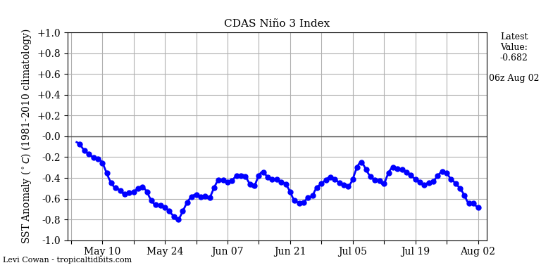
Latest ONI Values of ENSO - NINA Weak Albeit taking shape
29JUN2016 22.6 0.4 25.9-0.1 27.1-0.4 29.1 0.3
06JUL2016 22.2 0.2 25.5-0.4 27.0-0.4 29.1 0.3
13JUL2016 21.8 0.0 25.1-0.6 26.7-0.6 29.1 0.3
Hope this can hold on here - that warmth in Greenland and Iceland regions would be a nice NAO Block - timing is everything ugghhh!!!

_________________
Mugs
AKA:King: Snow Weenie
Self Proclaimed
WINTER 2014-15 : 55.12" +.02 for 6 coatings (avg. 35")
WINTER 2015-16 Total - 29.8" (Avg 35")
WINTER 2016-17 : 39.5" so far
amugs- Advanced Forecaster - Mod
- Posts : 15093
Reputation : 213
Join date : 2013-01-07
Age : 54
Location : Hillsdale,NJ
Re: Long Range Thread 11.0
![]() by algae888 Mon Jul 18, 2016 5:49 pm
by algae888 Mon Jul 18, 2016 5:49 pm


algae888- Advanced Forecaster
- Posts : 5311
Reputation : 46
Join date : 2013-02-05
Age : 61
Location : mt. vernon, new york
Re: Long Range Thread 11.0
![]() by amugs Mon Jul 18, 2016 9:53 pm
by amugs Mon Jul 18, 2016 9:53 pm
_________________
Mugs
AKA:King: Snow Weenie
Self Proclaimed
WINTER 2014-15 : 55.12" +.02 for 6 coatings (avg. 35")
WINTER 2015-16 Total - 29.8" (Avg 35")
WINTER 2016-17 : 39.5" so far
amugs- Advanced Forecaster - Mod
- Posts : 15093
Reputation : 213
Join date : 2013-01-07
Age : 54
Location : Hillsdale,NJ
Re: Long Range Thread 11.0
![]() by amugs Sat Jul 23, 2016 12:32 pm
by amugs Sat Jul 23, 2016 12:32 pm
+ AMO and PDO couplet will be a driver - warm fall and we transition mid to latish to winter as teh cold from teh central core of the US builds east and then we flip - analog years I have been researching and hearing about it 93-94, 59-60 - much different than 11-12 - the Atlantic and pacific as we transition into a La Nina state that will be weak from LR data. PDO is 5th strongest on record.
LOTSSSSSSSSSSSSSSS of time of course.
_________________
Mugs
AKA:King: Snow Weenie
Self Proclaimed
WINTER 2014-15 : 55.12" +.02 for 6 coatings (avg. 35")
WINTER 2015-16 Total - 29.8" (Avg 35")
WINTER 2016-17 : 39.5" so far
amugs- Advanced Forecaster - Mod
- Posts : 15093
Reputation : 213
Join date : 2013-01-07
Age : 54
Location : Hillsdale,NJ
Re: Long Range Thread 11.0
![]() by nutleyblizzard Sat Jul 23, 2016 1:38 pm
by nutleyblizzard Sat Jul 23, 2016 1:38 pm
While I agree with your analysis, its way too soon to speculate what type of potential pattern could set up this upcoming winter. I start to pay attention on or about Labor Day at the earliest. While a weak La Nina is a good start, I really want to see the Atlantic blocking to settle in just in time for winter. Problem is the NAO is a feature that's often poorly modeled, so we won't really know until a week out at any given time.amugs wrote:LR look to winter:
+ AMO and PDO couplet will be a driver - warm fall and we transition mid to latish to winter as teh cold from teh central core of the US builds east and then we flip - analog years I have been researching and hearing about it 93-94, 59-60 - much different than 11-12 - the Atlantic and pacific as we transition into a La Nina state that will be weak from LR data. PDO is 5th strongest on record.
LOTSSSSSSSSSSSSSSS of time of course.

nutleyblizzard- Senior Enthusiast
- Posts : 1952
Reputation : 41
Join date : 2014-01-30
Age : 58
Location : Nutley, new jersey
Re: Long Range Thread 11.0
![]() by amugs Mon Jul 25, 2016 5:40 pm
by amugs Mon Jul 25, 2016 5:40 pm

_________________
Mugs
AKA:King: Snow Weenie
Self Proclaimed
WINTER 2014-15 : 55.12" +.02 for 6 coatings (avg. 35")
WINTER 2015-16 Total - 29.8" (Avg 35")
WINTER 2016-17 : 39.5" so far
amugs- Advanced Forecaster - Mod
- Posts : 15093
Reputation : 213
Join date : 2013-01-07
Age : 54
Location : Hillsdale,NJ
Re: Long Range Thread 11.0
![]() by algae888 Wed Jul 27, 2016 9:12 pm
by algae888 Wed Jul 27, 2016 9:12 pm

algae888- Advanced Forecaster
- Posts : 5311
Reputation : 46
Join date : 2013-02-05
Age : 61
Location : mt. vernon, new york
Re: Long Range Thread 11.0
![]() by Frank_Wx Thu Jul 28, 2016 5:55 am
by Frank_Wx Thu Jul 28, 2016 5:55 am
I'm not ready for winter yet...
_________________
_______________________________________________________________________________________________________
CLICK HERE to view NJ Strong Snowstorm Classifications

Frank_Wx- Godzilla Seeker

- Posts : 21305
Reputation : 328
Join date : 2013-01-05
Age : 31
Location : Jersey City, NJ -

Re: Long Range Thread 11.0
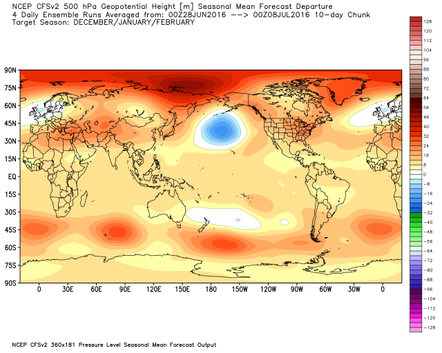
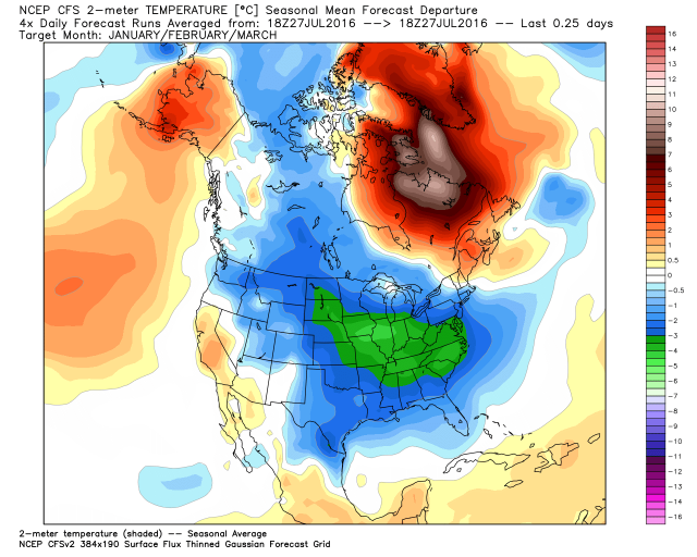
![]() by amugs Thu Jul 28, 2016 1:56 pm
by amugs Thu Jul 28, 2016 1:56 pm
Frank_Wx wrote:Haha, nice.
I'm not ready for winter yet...
CFS v2 says we'd better start splittin the wood and stockin' up on teh dry goods!!! Crips this is a little ice age winter map!!
_________________
Mugs
AKA:King: Snow Weenie
Self Proclaimed
WINTER 2014-15 : 55.12" +.02 for 6 coatings (avg. 35")
WINTER 2015-16 Total - 29.8" (Avg 35")
WINTER 2016-17 : 39.5" so far
amugs- Advanced Forecaster - Mod
- Posts : 15093
Reputation : 213
Join date : 2013-01-07
Age : 54
Location : Hillsdale,NJ
Re: Long Range Thread 11.0
![]() by weatherwatchermom Thu Jul 28, 2016 2:38 pm
by weatherwatchermom Thu Jul 28, 2016 2:38 pm
amugs wrote:Frank_Wx wrote:Haha, nice.
I'm not ready for winter yet...
CFS v2 says we'd better start splittin the wood and stockin' up on teh dry goods!!! Crips this is a little ice age winter map!!
from your mouth to g.. ears!!! bring it on!!

weatherwatchermom- Senior Enthusiast
- Posts : 3733
Reputation : 77
Join date : 2014-11-25
Age : 60
Location : Hazlet Township, NJ
Re: Long Range Thread 11.0
![]() by Frank_Wx Sat Jul 30, 2016 10:00 am
by Frank_Wx Sat Jul 30, 2016 10:00 am
_________________
_______________________________________________________________________________________________________
CLICK HERE to view NJ Strong Snowstorm Classifications
Frank_Wx- Godzilla Seeker
- Posts : 21305
Reputation : 328
Join date : 2013-01-05
Age : 31
Location : Jersey City, NJ -
Re: Long Range Thread 11.0
![]() by frank 638 Sat Jul 30, 2016 12:57 pm
by frank 638 Sat Jul 30, 2016 12:57 pm
frank 638- Senior Enthusiast
- Posts : 2824
Reputation : 37
Join date : 2016-01-01
Age : 40
Location : bronx ny
Re: Long Range Thread 11.0
![]() by Frank_Wx Sat Jul 30, 2016 2:00 pm
by Frank_Wx Sat Jul 30, 2016 2:00 pm
frank 638 wrote:Will this boring weather last into Aug or will we see a change
It won't get interesting until the Tropics heat up
_________________
_______________________________________________________________________________________________________
CLICK HERE to view NJ Strong Snowstorm Classifications
Frank_Wx- Godzilla Seeker
- Posts : 21305
Reputation : 328
Join date : 2013-01-05
Age : 31
Location : Jersey City, NJ -
Re: Long Range Thread 11.0
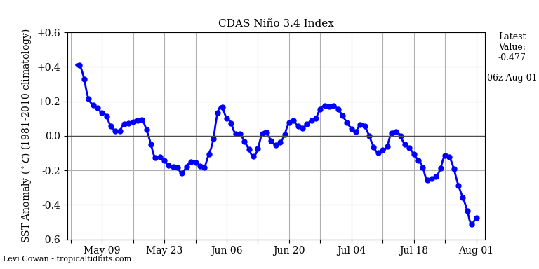
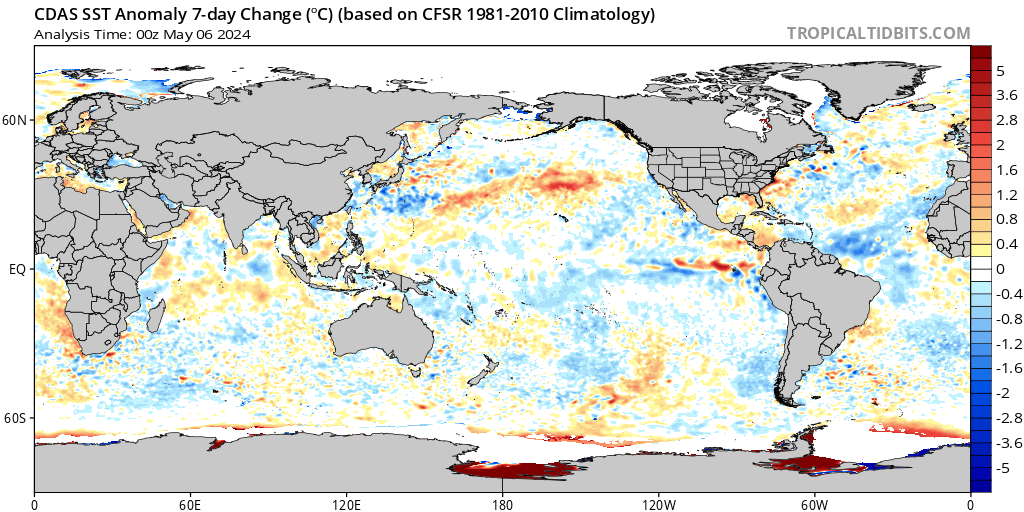
![]() by algae888 Mon Aug 01, 2016 6:58 pm
by algae888 Mon Aug 01, 2016 6:58 pm
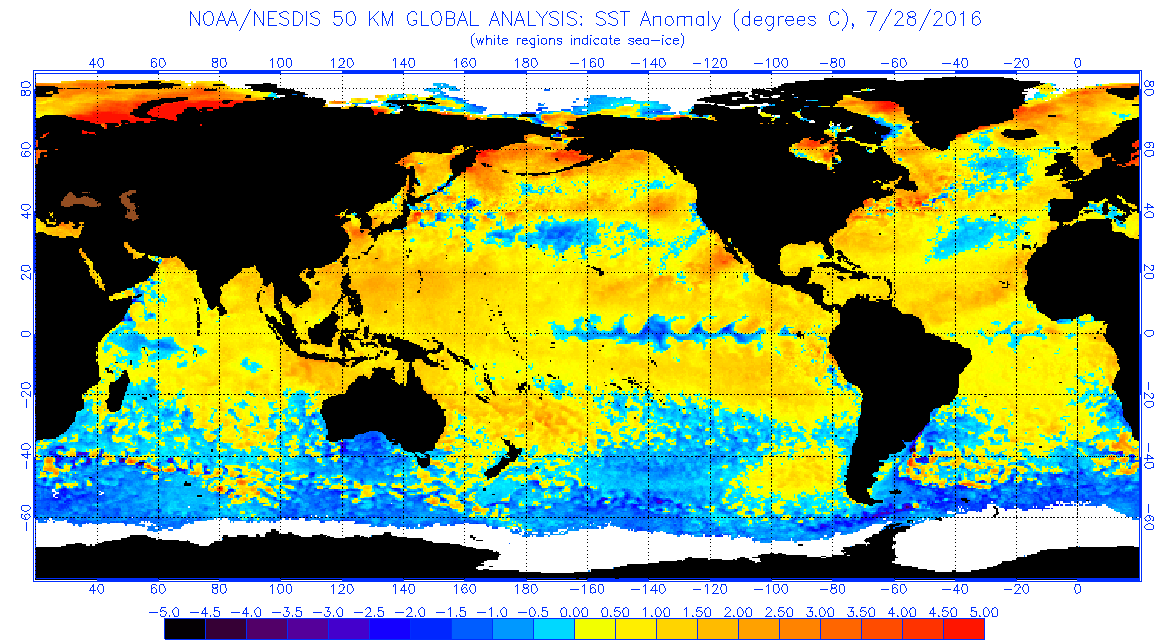
now

2007
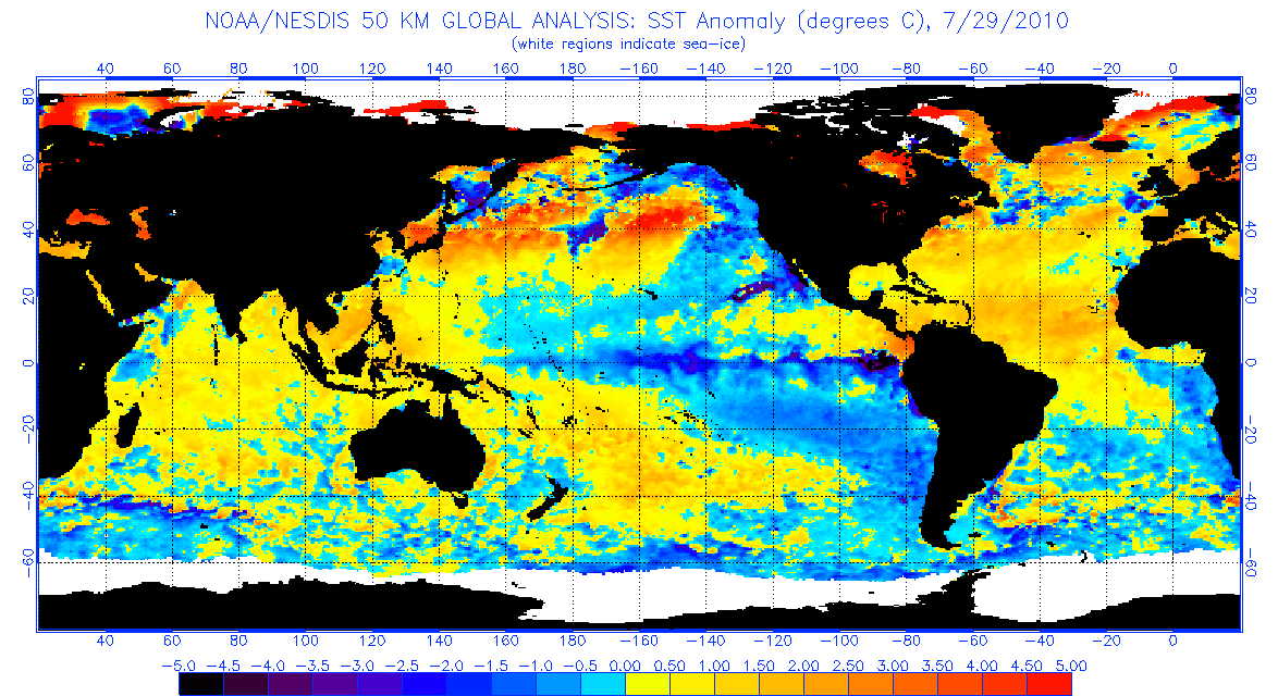
2010
last two images were last two mod nina's in mid summer. looks much different than this years pac. weak nina or even neutral enso looks like a good bet right now.

algae888- Advanced Forecaster
- Posts : 5311
Reputation : 46
Join date : 2013-02-05
Age : 61
Location : mt. vernon, new york
Re: Long Range Thread 11.0
![]() by dkodgis Tue Aug 02, 2016 9:32 am
by dkodgis Tue Aug 02, 2016 9:32 am

dkodgis- Senior Enthusiast
- Posts : 2493
Reputation : 98
Join date : 2013-12-29
Re: Long Range Thread 11.0
![]() by algae888 Wed Aug 03, 2016 9:52 am
by algae888 Wed Aug 03, 2016 9:52 am

some thoughts from mets on other boards....
"neutral enso and a +pdo = fridged winter."
"neutral enso weak mjo no stato warming what's driving the -nao? atlantic sst!"

algae888- Advanced Forecaster
- Posts : 5311
Reputation : 46
Join date : 2013-02-05
Age : 61
Location : mt. vernon, new york
Re: Long Range Thread 11.0
![]() by algae888 Wed Aug 03, 2016 10:00 am
by algae888 Wed Aug 03, 2016 10:00 am


algae888- Advanced Forecaster
- Posts : 5311
Reputation : 46
Join date : 2013-02-05
Age : 61
Location : mt. vernon, new york
Page 25 of 27 • 1 ... 14 ... 24, 25, 26, 27 ![]()
|
|
|