
 Search
Long Range Thread 16.0
Page 23 of 34 •  1 ... 13 ... 22, 23, 24 ... 28 ... 34
 ![]()
Re: Long Range Thread 16.0
![]() by SoulSingMG Wed Mar 14, 2018 8:16 pm
by SoulSingMG Wed Mar 14, 2018 8:16 pm
P.s. I have support from the wx gods on this ;-)
SoulSingMG- Senior Enthusiast

- Posts : 2853
Join date : 2013-12-11
Re: Long Range Thread 16.0
![]() by amugs Wed Mar 14, 2018 8:27 pm
by amugs Wed Mar 14, 2018 8:27 pm
Mike I strongly disagree with this.Math23x7 wrote:That's exactly right mugs, if this was January, we'd be in business with this -EPO. But since it's March, it's not going to help out as much, especially for the city.
If we get a N4/5 SD EPO with a NAO block the cold will one and get trapped underneath. You HP doesn't just slide out as easy even with a N 2SD NAO. The Frick ingredients heat engine of NYC is a joke and it could be the middle of JAN and 30*out and snow will have an issue stuking. AND it is not due to the climate it's due to the massive amounts of thermal dynamics underground with that place, all the utilities, subway, etc as eell as jsut heat from the buildings produced. Manhattan more so, not da Bronx or King of Queens as much.
This is storm going to press S as it comes across.where the trough is off the west coast is where you see it exit off the east coast. Going to be fun to track and please let's not take op runs verbatim here they will be all over the place with rain (some will flip and throw in the towel and say see) others will show snow and (weenies will jump for joy) only both to be flipped. Lots of time.
End are the way to go here.
amugs- Advanced Forecaster - Mod

- Posts : 15093
Join date : 2013-01-07
Re: Long Range Thread 16.0
![]() by billg315 Wed Mar 14, 2018 10:02 pm
by billg315 Wed Mar 14, 2018 10:02 pm

billg315- Advanced Forecaster - Mod
- Posts : 4467
Reputation : 185
Join date : 2015-01-24
Age : 50
Location : Flemington, NJ
Re: Long Range Thread 16.0
![]() by Frank_Wx Wed Mar 14, 2018 10:17 pm
by Frank_Wx Wed Mar 14, 2018 10:17 pm
_________________
_______________________________________________________________________________________________________
CLICK HERE to view NJ Strong Snowstorm Classifications

Frank_Wx- Godzilla Seeker

- Posts : 21305
Reputation : 328
Join date : 2013-01-05
Age : 31
Location : Jersey City, NJ -

Re: Long Range Thread 16.0
![]() by billg315 Wed Mar 14, 2018 10:23 pm
by billg315 Wed Mar 14, 2018 10:23 pm
billg315- Advanced Forecaster - Mod
- Posts : 4467
Reputation : 185
Join date : 2015-01-24
Age : 50
Location : Flemington, NJ
Re: Long Range Thread 16.0
![]() by Radz Wed Mar 14, 2018 10:36 pm
by Radz Wed Mar 14, 2018 10:36 pm
Don't the other globals also show a piece of energy behind the initial low as well? Maybe not to the extent of the GFS...billg315 wrote:Agreed. Doesn’t make any sense and not sure if I’ve ever seen that actually happen. Wondering if it’s picking up on something else of significance and just spitting it out with the wrong solution or if it’s just SNAFU for the gfs.

Radz- Pro Enthusiast

- Posts : 1028
Reputation : 17
Join date : 2013-01-12
Location : Cortlandt Manor NY
Re: Long Range Thread 16.0
![]() by jmanley32 Wed Mar 14, 2018 11:03 pm
by jmanley32 Wed Mar 14, 2018 11:03 pm
big storm? LolFrank_Wx wrote:It's BS

jmanley32- Senior Enthusiast
- Posts : 20516
Reputation : 108
Join date : 2013-12-12
Age : 42
Location : Yonkers, NY
Re: Long Range Thread 16.0
![]() by WeatherBob Wed Mar 14, 2018 11:28 pm
by WeatherBob Wed Mar 14, 2018 11:28 pm
Let me rephrase that, I see the cold air but will it get here and stay . Tough with that WNW flow trying to keep the cold air in . Wait and see.

WeatherBob- Meteorologist

- Posts : 683
Reputation : 83
Join date : 2013-12-13
Location : Caldwell, NJ - NW Essex County - Altitude 500 FT
Re: Long Range Thread 16.0
![]() by essexcountypete Wed Mar 14, 2018 11:48 pm
by essexcountypete Wed Mar 14, 2018 11:48 pm
RJB8525 wrote:Mt Holly lol
.DAYS TWO THROUGH SEVEN...Thursday through Tuesday.
A coastal storm may affect the area Tuesday and Tuesday night,
however the details and therefore any impacts are uncertain at this
time.
That's the same thing they've had for a few days now.
Meanwhile, Upton chats us up...
Continue to monitor a coastal low that is progged to impact the area from late Monday night into the middle of next week. Models continue to struggle in handling a cutoff low currently over the western Gulf of Alaska. They differ in how quickly it comes inland, and how quickly and how intact it ends up emerging from the Central Rockies. Then they differ on how it interacts with the existing closed low over the Canadian Maritimes (they also differ on how the handle this). The models have in general shifted northward with their coastal low track, with the GFS the farthest N (near/over Long Island) and the CMC and ECMWF still keeping the low south of Long Island, but to the S/E vice N/W of the 40N/70W benchmark respectively. Believe the GFS remains an outlier in how it is handling the system (in part in its evolution of current closed low over Canadian Maritimes and that it appears to weaken/shear the western cutoff more so than other solutions). So for now have used a ECMWF/CMC blend for the forecast for Monday night-Wednesday.
In terms of sensible weather, expect mainly snow to develop from SW to NE late Monday night. For now calling for the snow to a wintry mix over the N 1/2 of the CWA Tuesday-Wednesday and snow and rain over the S 1/2 of the CWA. Do expect precipitation to taper off on Wednesday as the storm slowly exits to the NE. There is still quite a bit uncertainty over the exact strength and track of this storm and hence its ultimate impacts to the CWA. It does appear that there could be a period of strong gusty winds as the storm passes to the S/SE Tuesday and Tuesday night. This could result in some coastal issues, refer to the tides and coastal flooding section of the AFD for further information.

essexcountypete- Pro Enthusiast
- Posts : 783
Reputation : 12
Join date : 2013-12-09
Location : Bloomfield, NJ
Re: Long Range Thread 16.0
![]() by Math23x7 Wed Mar 14, 2018 11:51 pm
by Math23x7 Wed Mar 14, 2018 11:51 pm
I agree
Math23x7- Wx Statistician Guru

- Posts : 2379
Reputation : 68
Join date : 2013-01-08
Re: Long Range Thread 16.0
![]() by docstox12 Thu Mar 15, 2018 5:22 am
by docstox12 Thu Mar 15, 2018 5:22 am

docstox12- Wx Statistician Guru
- Posts : 8504
Reputation : 222
Join date : 2013-01-07
Age : 73
Location : Monroe NY
Re: Long Range Thread 16.0
![]() by jmanley32 Thu Mar 15, 2018 6:23 am
by jmanley32 Thu Mar 15, 2018 6:23 am
jmanley32- Senior Enthusiast
- Posts : 20516
Reputation : 108
Join date : 2013-12-12
Age : 42
Location : Yonkers, NY
Re: Long Range Thread 16.0
![]() by amugs Thu Mar 15, 2018 7:05 am
by amugs Thu Mar 15, 2018 7:05 am
Just like the last 2 storms.docstox12 wrote:NWS now tooting the all snow horn up here in the Hudson Valley.Snow from Monday night to Wednesday night.Long disco on the matter.Even Lee Goldberg was on board last night after waffling Tuesday night saying it was moving S and E on his interpretation and we would have a light snow event.Days away so anything can happen, but definitely something is flashing.
_________________
Mugs
AKA:King: Snow Weenie
Self Proclaimed
WINTER 2014-15 : 55.12" +.02 for 6 coatings (avg. 35")
WINTER 2015-16 Total - 29.8" (Avg 35")
WINTER 2016-17 : 39.5" so far

amugs- Advanced Forecaster - Mod
- Posts : 15093
Reputation : 213
Join date : 2013-01-07
Age : 54
Location : Hillsdale,NJ
Re: Long Range Thread 16.0
![]() by jmanley32 Thu Mar 15, 2018 7:27 am
by jmanley32 Thu Mar 15, 2018 7:27 am
jmanley32- Senior Enthusiast
- Posts : 20516
Reputation : 108
Join date : 2013-12-12
Age : 42
Location : Yonkers, NY
Re: Long Range Thread 16.0
![]() by SNOW MAN Thu Mar 15, 2018 7:49 am
by SNOW MAN Thu Mar 15, 2018 7:49 am
docstox12 wrote:NWS now tooting the all snow horn up here in the Hudson Valley.Snow from Monday night to Wednesday night.Long disco on the matter.Even Lee Goldberg was on board last night after waffling Tuesday night saying it was moving S and E on his interpretation and we would have a light snow event.Days away so anything can happen, but definitely something is flashing.
Good morning Doc. The thing that makes me nervous is when the media starts agreeing that there's going to be a storm. That could be the KOD for our event.

SNOW MAN- Senior Enthusiast
- Posts : 1361
Reputation : 25
Join date : 2013-01-13
Age : 64
Location : Marshalls Creek Pa.
Re: Long Range Thread 16.0
![]() by Frank_Wx Thu Mar 15, 2018 8:03 am
by Frank_Wx Thu Mar 15, 2018 8:03 am
EPS

EURO

CMC

UKIE
.thumb.gif.d4bca41b996a8de4c79a6e54de8df467.gif)
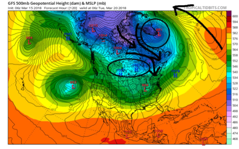
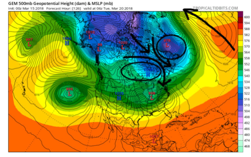
Other models besides GFS showing the 2-low idea. I still am not buying it but we will see.
_________________
_______________________________________________________________________________________________________
CLICK HERE to view NJ Strong Snowstorm Classifications
Frank_Wx- Godzilla Seeker
- Posts : 21305
Reputation : 328
Join date : 2013-01-05
Age : 31
Location : Jersey City, NJ -
Re: Long Range Thread 16.0
![]() by dkodgis Thu Mar 15, 2018 8:07 am
by dkodgis Thu Mar 15, 2018 8:07 am

dkodgis- Senior Enthusiast
- Posts : 2501
Reputation : 98
Join date : 2013-12-29
Re: Long Range Thread 16.0
![]() by sroc4 Thu Mar 15, 2018 8:23 am
by sroc4 Thu Mar 15, 2018 8:23 am
WeatherBob wrote:I know it’s kind of early but, where is the cold air for the storm? My gut feeling is that we will lack sufficient cold air in the NY Metro area. I will wait until Saturday to confirm my suspicions.
Let me rephrase that, I see the cold air but will it get here and stay . Tough with that WNW flow trying to keep the cold air in . Wait and see.
On all global models you have 3 key features that will combine to provide the cold air source, the details; however, are still variable. Euro, GFS, CMC, and Ukie early next week you see our LP headed towards the Ohio river valley where it runs into:
1) A strong HP to the north discharged directly from Northern Canada compliments of the upper level Pacific pattern and N Atlantic Pattern which triggers a transfer of energy somewhere off the EC
2) Our last nor'easter from the 12th-13th is bottled up somewhere off the EC of Canada/S Greenland acting somehwat as our 50/50 low (although not quite on 50n/50W) helping our cause because...
3) There is still a -NAO, albeit breaking down and backing off, and more like an east based look in the N Atlantic.
The positioning of the HP to the north and the low to the NE provides a nice frigid source region from which a transferring and deepening low pressure system off the EC to tap into. The set up is def there for a cold air source, but its the details in the transfer timing, position, and how fast we deepen/phase etc that will determine the IMBY details here. Despite Mikey's overwhelmingly pessimistic analysis on the situation, the coast is 100% in the game with this set up for accumulation at this stage of tracking. In his back yard will be tough because again we do have climatology against us here if the timing of the precip is mid day, but as far as late March storms go this is a pretty decent set up for the coast if the Track is right. Of course climatology will always favor interior to do better this time of year. The details cont to be fuzzy but some of them, for instance the idea of a Miller B set up, is starting to come into focus. The details of said set up wont come into true focus until the weekend at the earliest; even then as we have seen with 3 straight NorEasters the minute details come to light under 24-48hrs.
Both optimistic, and pessimistic sides of the camp really need to avoid any such definitive statements about the details of this storm right now as we all should know better.


_________________
"In weather and in life, there's no winning and losing; there's only winning and learning."
WINTER 2012/2013 TOTALS 43.65"WINTER 2017/2018 TOTALS 62.85" WINTER 2022/2023 TOTALS 4.9"
WINTER 2013/2014 TOTALS 64.85"WINTER 2018/2019 TOTALS 14.25" WINTER 2023/2024 TOTALS 13.1"
WINTER 2014/2015 TOTALS 71.20"WINTER 2019/2020 TOTALS 6.35"
WINTER 2015/2016 TOTALS 35.00"WINTER 2020/2021 TOTALS 37.75"
WINTER 2016/2017 TOTALS 42.25"WINTER 2021/2022 TOTALS 31.65"

sroc4- Admin
- Posts : 8331
Reputation : 301
Join date : 2013-01-07
Location : Wading River, LI
Re: Long Range Thread 16.0
![]() by Guest Thu Mar 15, 2018 8:39 am
by Guest Thu Mar 15, 2018 8:39 am
Guest- Guest
Re: Long Range Thread 16.0
![]() by dkodgis Thu Mar 15, 2018 8:53 am
by dkodgis Thu Mar 15, 2018 8:53 am
dkodgis- Senior Enthusiast
- Posts : 2501
Reputation : 98
Join date : 2013-12-29
Re: Long Range Thread 16.0
![]() by WeatherBob Thu Mar 15, 2018 9:02 am
by WeatherBob Thu Mar 15, 2018 9:02 am
WeatherBob- Meteorologist
- Posts : 683
Reputation : 83
Join date : 2013-12-13
Location : Caldwell, NJ - NW Essex County - Altitude 500 FT
Re: Long Range Thread 16.0
![]() by sroc4 Thu Mar 15, 2018 9:21 am
by sroc4 Thu Mar 15, 2018 9:21 am
WeatherBob wrote:Scott, you are very detailed as usual. I was talking about a WNW flow aloft with weak low level cold air advection . It could turn out that way in the end but way to early to say. I will keep my mouth shut and wait till the weekend runs to see what our fearless models indicate.
I hear what you’re saying Bob. However with the current lead time for the storm I prefer not to look at those types of details. For now it’s still big picture, pattern recognition, which I think is favorable for cyclogenesis off our coast. This time of year for the coast, we usually have to rely on the dynamics of a storm to generate the cold as even a cold air mass is moderated heavily due to climatology. Modeling never sees those details with this type of lead time. Where the heaviest precept falls, what type of storm track, upper level jet dynamics, what time of day does the heaviest precept fall, etc. none of these things can be pointed out in any type of detail at this stage. So again my post, even though it was quoting you specifically, was not directed at you per se. I simply wanted to point out the fact that the big picture can certainly support a) cyclogenesis off the east coast, and b) cold air is available for this storm if it’s dynamic enough.
_________________
"In weather and in life, there's no winning and losing; there's only winning and learning."
WINTER 2012/2013 TOTALS 43.65"WINTER 2017/2018 TOTALS 62.85" WINTER 2022/2023 TOTALS 4.9"
WINTER 2013/2014 TOTALS 64.85"WINTER 2018/2019 TOTALS 14.25" WINTER 2023/2024 TOTALS 13.1"
WINTER 2014/2015 TOTALS 71.20"WINTER 2019/2020 TOTALS 6.35"
WINTER 2015/2016 TOTALS 35.00"WINTER 2020/2021 TOTALS 37.75"
WINTER 2016/2017 TOTALS 42.25"WINTER 2021/2022 TOTALS 31.65"
sroc4- Admin
- Posts : 8331
Reputation : 301
Join date : 2013-01-07
Location : Wading River, LI
Re: Long Range Thread 16.0
![]() by amugs Thu Mar 15, 2018 9:47 am
by amugs Thu Mar 15, 2018 9:47 am
Remember the N EPO will send the HP through the Upper Midwest & North Country and the low level cold air will press (Banana High look here) on the EPS below). The position of that HP is going to be a factor of course in the evolution if this storm. OP runs will NOT see this but ENS will do a better job of seeing such. Again as with potent storms details within the 12- 48 time frame are when we see what is going to things shape up.
I love this look of the EURO EPS location of he Nor'easter. This has a classic look to it IMO. MANY major snowstorm analogs have had this look. Lets see if we can get this bad boy to bring us some luv!
PB map

Earthlight indicy maps here thx
Snowfall - this is impressive at this stage - stickage on the furnace is a different story - burbs and ruburbs yes

Half filled or Half Empty tis the question??

_________________
Mugs
AKA:King: Snow Weenie
Self Proclaimed
WINTER 2014-15 : 55.12" +.02 for 6 coatings (avg. 35")
WINTER 2015-16 Total - 29.8" (Avg 35")
WINTER 2016-17 : 39.5" so far
amugs- Advanced Forecaster - Mod
- Posts : 15093
Reputation : 213
Join date : 2013-01-07
Age : 54
Location : Hillsdale,NJ
Re: Long Range Thread 16.0
![]() by weatherwatchermom Thu Mar 15, 2018 9:49 am
by weatherwatchermom Thu Mar 15, 2018 9:49 am
Joe Cioffi...about 10 min in...starts talking about the next threat.
https://www.nycweathernow.com/noreaster-number-four-possibility-enters-picture/

weatherwatchermom- Senior Enthusiast
- Posts : 3740
Reputation : 77
Join date : 2014-11-25
Age : 60
Location : Hazlet Township, NJ
Re: Long Range Thread 16.0
![]() by Math23x7 Thu Mar 15, 2018 9:56 am
by Math23x7 Thu Mar 15, 2018 9:56 am
amugs wrote:Great detailed post as usual Scott.
Remember the N EPO will send the HP through the Upper Midwest & North Country and the low level cold air will press (Banana High look here) on the EPS below). The position of that HP is going to be a factor of course in the evolution if this storm. OP runs will NOT see this but ENS will do a better job of seeing such. Again as with potent storms details within the 12- 48 time frame are when we see what is going to things shape up.
I love this look of the EURO EPS location of he Nor'easter. This has a classic look to it IMO. MANY major snowstorm analogs have had this look. Lets see if we can get this bad boy to bring us some luv!
PB map
Earthlight indicy maps here thx
Snowfall - this is impressive at this stage - stickage on the furnace is a different story - burbs and ruburbs yes
Half filled or Half Empty tis the question??
Remember this is based on 10:1 ratio. Earlier this week, CPK had 0.28" qpf in the form of snow, which by 10:1 ratio would be 2.8" of snow but it ended up with a trace since it was above freezing. Last week, CPK had 1.39" qpf in the form of snow which by 10:1 ratio would be 13.9" of snow but it ended up with 3.2" since it was, you guessed it, above freezing.
Math23x7- Wx Statistician Guru
- Posts : 2379
Reputation : 68
Join date : 2013-01-08
Re: Long Range Thread 16.0
![]() by amugs Thu Mar 15, 2018 10:22 am
by amugs Thu Mar 15, 2018 10:22 am
Math23x7 wrote:amugs wrote:Great detailed post as usual Scott.
Remember the N EPO will send the HP through the Upper Midwest & North Country and the low level cold air will press (Banana High look here) on the EPS below). The position of that HP is going to be a factor of course in the evolution if this storm. OP runs will NOT see this but ENS will do a better job of seeing such. Again as with potent storms details within the 12- 48 time frame are when we see what is going to things shape up.
I love this look of the EURO EPS location of he Nor'easter. This has a classic look to it IMO. MANY major snowstorm analogs have had this look. Lets see if we can get this bad boy to bring us some luv!
PB map
Earthlight indicy maps here thx
Snowfall - this is impressive at this stage - stickage on the furnace is a different story - burbs and ruburbs yes
Half filled or Half Empty tis the question??
Remember this is based on 10:1 ratio. Earlier this week, CPK had 0.28" qpf in the form of snow, which by 10:1 ratio would be 2.8" of snow but it ended up with a trace since it was above freezing. Last week, CPK had 1.39" qpf in the form of snow which by 10:1 ratio would be 13.9" of snow but it ended up with 3.2" since it was, you guessed it, above freezing.
Mike yes you are correct. The fact that it sees this much snowfall in this range is WOW worthy for this time of year. Stickage is a different story of course and as I said the heat engine of NYC needs 30* and lower for snow to stick and even then DeBlasio will turn up the pressure of the underground steam pipes (increase pressure = increase temperature) and it won't stick. NYC is a mini microclimate, face it. Climo preferes N and W of the city for this time in March. Cp and Doc and the rest of those in the HV , NWNJ are cashing in and should be even more.
Look at this map for March so far = epic for some (not KYNC of course)

_________________
Mugs
AKA:King: Snow Weenie
Self Proclaimed
WINTER 2014-15 : 55.12" +.02 for 6 coatings (avg. 35")
WINTER 2015-16 Total - 29.8" (Avg 35")
WINTER 2016-17 : 39.5" so far
amugs- Advanced Forecaster - Mod
- Posts : 15093
Reputation : 213
Join date : 2013-01-07
Age : 54
Location : Hillsdale,NJ
Re: Long Range Thread 16.0
![]() by Guest Thu Mar 15, 2018 10:28 am
by Guest Thu Mar 15, 2018 10:28 am
Guest- Guest
Page 23 of 34 • 1 ... 13 ... 22, 23, 24 ... 28 ... 34 ![]()
|
|
|