April 7th 2018 SNOW!!! AGAIN!!!
+23
frank 638
WeatherBob
Math23x7
MattyICE
Snow88
oldtimer
amugs
dkodgis
RJB8525
Scullybutcher
aiannone
heehaw453
skinsfan1177
jmanley32
Dtone
Dunnzoo
billg315
gigs68
Vinnydula
CPcantmeasuresnow
Grselig
mikeypizano
sroc4
27 posters
Page 3 of 3 •  1, 2, 3
 Re: April 7th 2018 SNOW!!! AGAIN!!!
Looks like 12z NAM is coming north.
nutleyblizzard- Senior Enthusiast

- Posts : 1954
Join date : 2014-01-30
 Re: April 7th 2018 SNOW!!! AGAIN!!!
Yep 12z NAM is north of 6z run. Not a dramatic shift, but a clear shift north. 6z had northern extent of snow south of a line from Philly to AC at 8 a.m. Saturday; the 12z run has it up to I-78 into Long Island. Heaviest band would still be across Del, SEPA, and SNJ, but it is a shift back in the direction of yesterday's models, so lets see if that is the start of a trend north (as we've seen often of late) to continue north in the 18z runs, or if it is an isolated or final shift.
billg315- Advanced Forecaster - Mod

- Posts : 4483
Join date : 2015-01-24
 Re: April 7th 2018 SNOW!!! AGAIN!!!
It’s done. Time to move on to the Hurricane season!

WeatherBob- Meteorologist

- Posts : 683
Reputation : 83
Join date : 2013-12-13
Location : Caldwell, NJ - NW Essex County - Altitude 500 FT
 Re: April 7th 2018 SNOW!!! AGAIN!!!
Evans just totally killed this

RJB8525- Senior Enthusiast

- Posts : 1994
Reputation : 28
Join date : 2013-02-06
Age : 38
Location : Hackettstown, NJ
 Re: April 7th 2018 SNOW!!! AGAIN!!!
So it's over let's just move on
frank 638- Senior Enthusiast

- Posts : 2843
Reputation : 37
Join date : 2016-01-01
Age : 40
Location : bronx ny
 Re: April 7th 2018 SNOW!!! AGAIN!!!
It's over. Stick a fork in the snow season.
Math23x7- Wx Statistician Guru

- Posts : 2379
Reputation : 68
Join date : 2013-01-08
 Re: April 7th 2018 SNOW!!! AGAIN!!!
12z GFS not much changed from this morning and not much different than the 12z NAM. Shows snow in the morning as far north as central-north Jersey and Long Island. But keeps the heaviest snow over South Jersey. I choose not to write anything off at this point as I've seen these models vacillate like this too many times this winter including just last week. I would agree that the overnight runs were not a good sign for snow in this region and the midday runs have been only slightly better, but I can't totally write off a system when both the NAM and GFS as presently modeled have it snowing -- possibly moderately -- over my house Saturday morning. That wouldn't take a big shift to get me back into measurable snow.
Anyway, what do I have to lose? It's not like I'm betting money on this or as if I'm not going to be looking at the next 36 hours of model runs anyway. lol
Anyway, what do I have to lose? It's not like I'm betting money on this or as if I'm not going to be looking at the next 36 hours of model runs anyway. lol

billg315- Advanced Forecaster - Mod

- Posts : 4483
Reputation : 185
Join date : 2015-01-24
Age : 50
Location : Flemington, NJ
 Re: April 7th 2018 SNOW!!! AGAIN!!!
Also for the record, Accuweather -- which largely relies on these models for its (admittedly unreliable) "snowfall probability" has me at a 40 percent chance of 3-6" of snow and 34 percent chance of 1-3" of snow. (13% chance of 6-10 if you want to go crazy, lol). So even relying on these unfavorable model outputs I'm still in accumulating snow. Granted I'm slightly further south than a lot of people on this board so a south shift isn't as dire for me as it may be for some of the people further north.

billg315- Advanced Forecaster - Mod

- Posts : 4483
Reputation : 185
Join date : 2015-01-24
Age : 50
Location : Flemington, NJ
 Re: April 7th 2018 SNOW!!! AGAIN!!!
Maybe a couple inches from CNJ on south, but this threat quickly diminished in the last 24 hours.
_________________
_______________________________________________________________________________________________________
CLICK HERE to view NJ Strong Snowstorm Classifications
 Re: April 7th 2018 SNOW!!! AGAIN!!!
I see all threats are gone so are we in the clear other than what's posted on scroll? So will it be clear sat?Frank_Wx wrote:Maybe a couple inches from CNJ on south, but this threat quickly diminished in the last 24 hours.

jmanley32- Senior Enthusiast

- Posts : 20535
Reputation : 108
Join date : 2013-12-12
Age : 43
Location : Yonkers, NY
 Re: April 7th 2018 SNOW!!! AGAIN!!!
heck yeah ugg tracking is soooo long though lol. I heard it's supposed be average to slightly above this year. Also severe storms but no real predicting those.WeatherBob wrote:It’s done. Time to move on to the Hurricane season!

jmanley32- Senior Enthusiast

- Posts : 20535
Reputation : 108
Join date : 2013-12-12
Age : 43
Location : Yonkers, NY
 Re: April 7th 2018 SNOW!!! AGAIN!!!
jmanley32 wrote:heck yeah ugg tracking is soooo long though lol. I heard it's supposed be average to slightly above this year. Also severe storms but no real predicting those.WeatherBob wrote:It’s done. Time to move on to the Hurricane season!
I would not write off Monday night yet. GGEM has a nice hit. Yes it’s only one model but you just never know.

CPcantmeasuresnow- Wx Statistician Guru

- Posts : 7274
Reputation : 230
Join date : 2013-01-07
Age : 103
Location : Eastern Orange County, NY
 Re: April 7th 2018 SNOW!!! AGAIN!!!
Bernie Rayno still not convinced threat is dead. Hard to believe a lion's share of guidance would be that off at this point though.
heehaw453- Advanced Forecaster

- Posts : 3906
Reputation : 86
Join date : 2014-01-20
Location : Bedminster Township, PA Elevation 600' ASL
 Re: April 7th 2018 SNOW!!! AGAIN!!!
I'm confused I don't the storm is it done deal for Saturday because I am hearing 1 to 3 inches of snow
frank 638- Senior Enthusiast

- Posts : 2843
Reputation : 37
Join date : 2016-01-01
Age : 40
Location : bronx ny
 Re: April 7th 2018 SNOW!!! AGAIN!!!
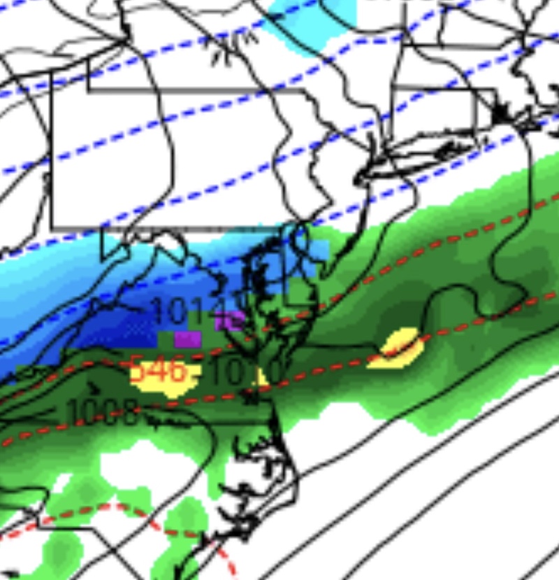
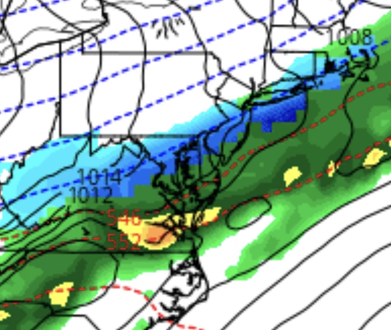
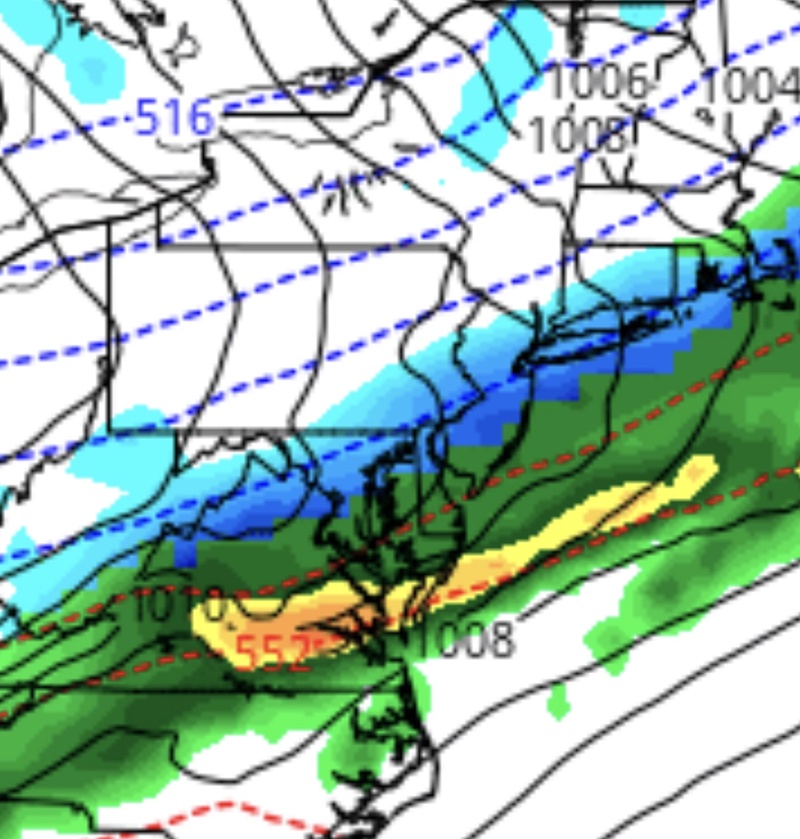
Current model guidance is south with heaviest precip and favors more snow over South Jersey. However. Here is why I wouldn’t completely write it off yet. As you can see 18z NAM is generally same as 12z but both are a big jump north from the 6z which is when people started writing it off:
8am Saturday:
6z NAM
12z NAM
18z NAM
8am Saturday:
6z NAM

12z NAM

18z NAM

Last edited by billg315 on Thu Apr 05, 2018 4:52 pm; edited 1 time in total (Reason for editing : Posted wrong 12zimage originally. 18z actually is north from 12z.)

billg315- Advanced Forecaster - Mod

- Posts : 4483
Reputation : 185
Join date : 2015-01-24
Age : 50
Location : Flemington, NJ
 Re: April 7th 2018 SNOW!!! AGAIN!!!
If I were forced to place my money, I’d say this is a South - to maybe parts of Central Jersey - event, possibly clipping Long Island too, as GFS and NAM support that now. But the fact that the NAM has creeped back north since this morning gives me pause.

billg315- Advanced Forecaster - Mod

- Posts : 4483
Reputation : 185
Join date : 2015-01-24
Age : 50
Location : Flemington, NJ
 Re: April 7th 2018 SNOW!!! AGAIN!!!
My local says 1 to 3.

jmanley32- Senior Enthusiast

- Posts : 20535
Reputation : 108
Join date : 2013-12-12
Age : 43
Location : Yonkers, NY
 Re: April 7th 2018 SNOW!!! AGAIN!!!
I actually just edited that post because I think I posted 18z twice (instead of the 12z pic). Now looking at 12z, the 18z is north of that too.

billg315- Advanced Forecaster - Mod

- Posts : 4483
Reputation : 185
Join date : 2015-01-24
Age : 50
Location : Flemington, NJ
 Re: April 7th 2018 SNOW!!! AGAIN!!!
To me it's two things. Weaker storm (frontal passage) and location. Yesterday was showing much stronger system and of course better location. I'd be more optimistic with stronger energy and then take chances on location.
heehaw453- Advanced Forecaster

- Posts : 3906
Reputation : 86
Join date : 2014-01-20
Location : Bedminster Township, PA Elevation 600' ASL
 Re: April 7th 2018 SNOW!!! AGAIN!!!
heehaw453 wrote:Bernie Rayno still not convinced threat is dead. Hard to believe a lion's share of guidance would be that off at this point though.
If he's looking at the NAM he might well be noticing that it has steadily marched back north since its leap south this morning. As I said above, I'd have to go with the current guidance showing the heaviest precip in South Jersey because the NAM and the GFS both show that. But I am still really hesitant to fully buy into the fact that this is a settled solution when the NAM had the northern extent of the precip south of Philly-AC this morning (50-75 miles south of where it was just 24 hours before) and now has it at the NJ/NY border.

billg315- Advanced Forecaster - Mod

- Posts : 4483
Reputation : 185
Join date : 2015-01-24
Age : 50
Location : Flemington, NJ
 Re: April 7th 2018 SNOW!!! AGAIN!!!
Lee has coating-1" for most of the area. 1-3 south but think's thats bullish now

RJB8525- Senior Enthusiast

- Posts : 1994
Reputation : 28
Join date : 2013-02-06
Age : 38
Location : Hackettstown, NJ
 Re: April 7th 2018 SNOW!!! AGAIN!!!
18z GFS:
5 am Sat.:
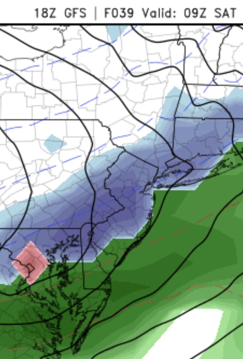
8 am Sat.:

5 am Sat.:

8 am Sat.:


billg315- Advanced Forecaster - Mod

- Posts : 4483
Reputation : 185
Join date : 2015-01-24
Age : 50
Location : Flemington, NJ
 Re: April 7th 2018 SNOW!!! AGAIN!!!
Per 18z GFS: Rain changes to snow around 2 or 3 am and ends by about 10 or 11 am for most. Duration wise that’s about the same as Mondays event. As you can see, it’s not that far south. A slight shift north COULD bring some mod.-to-heavy bands into some parts of this forecast area. This could be the last real shot at accumulating snow until December. I’m not giving up yet. Lol.

billg315- Advanced Forecaster - Mod

- Posts : 4483
Reputation : 185
Join date : 2015-01-24
Age : 50
Location : Flemington, NJ
 Re: April 7th 2018 SNOW!!! AGAIN!!!
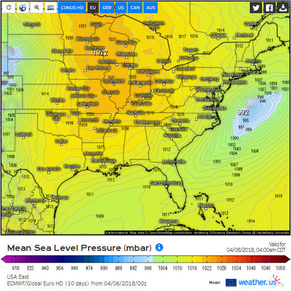
One thing I noticed that catches my attention is what happens Saturday night into Sunday morning.
Here is the 12Z EURO vs The 0Z EURO for 5 AM Sunday regarding surface pressure:
12Z hr 69:
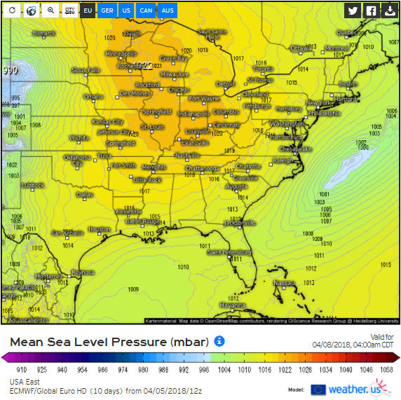
0Z hr 57:
And here is the significant weather for that time:
12Z hr 69:
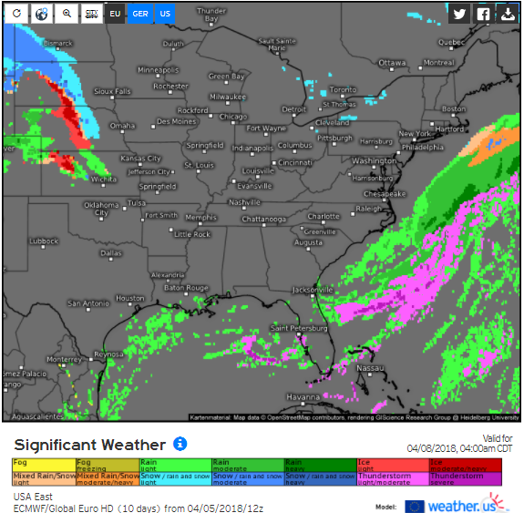
0Z hr 57:

Note: I am not saying this will happen. This is just an observation I noticed. We'll see throughout the day whether or not this northwest tick for early Sunday morning (the 8th) was a fluke.
Here is the 12Z EURO vs The 0Z EURO for 5 AM Sunday regarding surface pressure:
12Z hr 69:

0Z hr 57:

And here is the significant weather for that time:
12Z hr 69:

0Z hr 57:

Note: I am not saying this will happen. This is just an observation I noticed. We'll see throughout the day whether or not this northwest tick for early Sunday morning (the 8th) was a fluke.
Math23x7- Wx Statistician Guru

- Posts : 2379
Reputation : 68
Join date : 2013-01-08
 Re: April 7th 2018 SNOW!!! AGAIN!!!
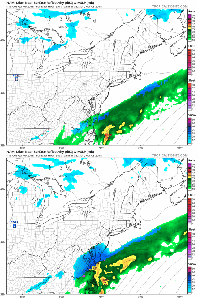
Nam and hi res man both NW


skinsfan1177- Senior Enthusiast

- Posts : 4485
Reputation : 35
Join date : 2013-01-07
Age : 46
Location : Point Pleasant Boro
 Re: April 7th 2018 SNOW!!! AGAIN!!!
Models definitely showing the second of the two “waves” or Lows along the front tracking more north and closer to the coast Saturday night into Sunday. But not close enough at this time to give hope to anyone but extreme South Jersey and the Jersey Shore. I guess I’d keep an eye on it for Cape May, Atlantic, Ocean and southern Monmouth and maybe eastern Long Island, but I doubt it gets far enough NW to give anyone else significant accumulation.

billg315- Advanced Forecaster - Mod

- Posts : 4483
Reputation : 185
Join date : 2015-01-24
Age : 50
Location : Flemington, NJ
 Re: April 7th 2018 SNOW!!! AGAIN!!!
I’m pretty much throwing up the white flag on this. Unless there is a dramatic last minute shift we are now inside if 24 hours for this system. Second wave’s track improved overnight but not enough (for most areas, maybe the shore). I guess there’s always hoping for miracles but I don’t see it shaking out right now. And while areas further north and west may still have hope later in April, my area has nearly zero history of accumulating snow after about April 10 so this was probably it for me. Beach time.

billg315- Advanced Forecaster - Mod

- Posts : 4483
Reputation : 185
Join date : 2015-01-24
Age : 50
Location : Flemington, NJ
Page 3 of 3 •  1, 2, 3
Permissions in this forum:
You cannot reply to topics in this forum|
|
|

 Home
Home