
 Search
Long Range Thread 18.0
Page 16 of 36 •  1 ... 9 ... 15, 16, 17 ... 26 ... 36
 ![]()
Re: Long Range Thread 18.0
![]() by brownie Mon Jan 21, 2019 10:37 am
by brownie Mon Jan 21, 2019 10:37 am
I can’t see them either. I haven’t been able to see the images he posts for a couple of days. Other posters’ images are fine.crippo84 wrote:Anyone else unable to see Frank's images?
brownie- Posts : 391
Join date : 2013-11-10
Re: Long Range Thread 18.0
![]() by nutleyblizzard Mon Jan 21, 2019 10:37 am
by nutleyblizzard Mon Jan 21, 2019 10:37 am
Did you log in?crippo84 wrote:Anyone else unable to see Frank's images?
nutleyblizzard- Senior Enthusiast

- Posts : 1952
Join date : 2014-01-30
Re: Long Range Thread 18.0
![]() by brownie Mon Jan 21, 2019 10:39 am
by brownie Mon Jan 21, 2019 10:39 am
Actually, it’s only some of Frank’s posts I can’t see. Not sure what makes some visible and some not.brownie wrote:I can’t see them either. I haven’t been able to see the images he posts for a couple of days. Other posters’ images are fine.crippo84 wrote:Anyone else unable to see Frank's images?
brownie- Posts : 391
Reputation : 17
Join date : 2013-11-10
Location : Parsippany, NJ
Re: Long Range Thread 18.0
![]() by nutleyblizzard Mon Jan 21, 2019 10:42 am
by nutleyblizzard Mon Jan 21, 2019 10:42 am

nutleyblizzard- Senior Enthusiast
- Posts : 1952
Reputation : 41
Join date : 2014-01-30
Age : 58
Location : Nutley, new jersey
Re: Long Range Thread 18.0
![]() by Guest Mon Jan 21, 2019 10:44 am
by Guest Mon Jan 21, 2019 10:44 am
Guest- Guest
Re: Long Range Thread 18.0
![]() by crippo84 Mon Jan 21, 2019 10:47 am
by crippo84 Mon Jan 21, 2019 10:47 am
nutleyblizzard wrote:Did you log in?crippo84 wrote:Anyone else unable to see Frank's images?
Gotta be logged in to be able to comment. Sometimes when others quote a comment hidden images will show. Maybe it's because I'm mobile who knows.

crippo84- Posts : 383
Reputation : 20
Join date : 2013-11-07
Age : 40
Location : East Village, NYC
Re: Long Range Thread 18.0
![]() by snowday111 Mon Jan 21, 2019 10:51 am
by snowday111 Mon Jan 21, 2019 10:51 am
snowday111- Posts : 92
Reputation : 1
Join date : 2013-01-07
Location : Monroe Twp. NJ (Middlesex County)
Re: Long Range Thread 18.0
![]() by jmanley32 Mon Jan 21, 2019 11:22 am
by jmanley32 Mon Jan 21, 2019 11:22 am
Euro ensembles show that for majority of coast, not many have snow for just west of NYC on east. Some are even cutters, lots of time but that would be par for the course this winter.nutleyblizzard wrote:I'm hearing there is limited cold air for the day 7 threat (so what else is new)? Fortunately we have time for the upper levels to iron things out.

jmanley32- Senior Enthusiast
- Posts : 20516
Reputation : 108
Join date : 2013-12-12
Age : 42
Location : Yonkers, NY
Re: Long Range Thread 18.0
![]() by amugs Mon Jan 21, 2019 2:09 pm
by amugs Mon Jan 21, 2019 2:09 pm
jmanley32 wrote:Euro ensembles show that for majority of coast, not many have snow for just west of NYC on east. Some are even cutters, lots of time but that would be par for the course this winter.nutleyblizzard wrote:I'm hearing there is limited cold air for the day 7 threat (so what else is new)? Fortunately we have time for the upper levels to iron things out.
As I stated last night in the Pen about the NAO needs to helps us or else this can run the spine of the Apps since the PNA is not in an ideal location at this time it is to far west and then another massive cold arctic air mass filters in as it leaves - sound familiar?
PNA ridge is off the WC
And the LP in the GL the aresian noted above will act as a kicker if this pattern is correct

_________________
Mugs
AKA:King: Snow Weenie
Self Proclaimed
WINTER 2014-15 : 55.12" +.02 for 6 coatings (avg. 35")
WINTER 2015-16 Total - 29.8" (Avg 35")
WINTER 2016-17 : 39.5" so far

amugs- Advanced Forecaster - Mod

- Posts : 15093
Reputation : 213
Join date : 2013-01-07
Age : 54
Location : Hillsdale,NJ
Re: Long Range Thread 18.0
![]() by amugs Mon Jan 21, 2019 2:57 pm
by amugs Mon Jan 21, 2019 2:57 pm
Current Stretch: 0 days
2019 total: 14 days (67%)
2018 total: 221 days (61%)
_________________
Mugs
AKA:King: Snow Weenie
Self Proclaimed
WINTER 2014-15 : 55.12" +.02 for 6 coatings (avg. 35")
WINTER 2015-16 Total - 29.8" (Avg 35")
WINTER 2016-17 : 39.5" so far
amugs- Advanced Forecaster - Mod
- Posts : 15093
Reputation : 213
Join date : 2013-01-07
Age : 54
Location : Hillsdale,NJ
Re: Long Range Thread 18.0
![]() by docstox12 Mon Jan 21, 2019 3:16 pm
by docstox12 Mon Jan 21, 2019 3:16 pm

docstox12- Wx Statistician Guru

- Posts : 8504
Reputation : 222
Join date : 2013-01-07
Age : 73
Location : Monroe NY

heehaw453- Advanced Forecaster

- Posts : 3906
Reputation : 86
Join date : 2014-01-20
Location : Bedminster Township, PA Elevation 600' ASL
Re: Long Range Thread 18.0
![]() by skinsfan1177 Mon Jan 21, 2019 8:40 pm
by skinsfan1177 Mon Jan 21, 2019 8:40 pm
heehaw453 wrote:LOL!
Crap model not so good

skinsfan1177- Senior Enthusiast
- Posts : 4485
Reputation : 35
Join date : 2013-01-07
Age : 46
Location : Point Pleasant Boro
Re: Long Range Thread 18.0
![]() by jmanley32 Mon Jan 21, 2019 11:23 pm
by jmanley32 Mon Jan 21, 2019 11:23 pm
We so wish, crushing blozzard there, everything I want in a storm, high amounts of snow and high winds. Too bad I am more likely to win the lottery than this to verify. BTW when does the other GFS phase out to this one? That may be bad news.skinsfan1177 wrote:heehaw453 wrote:LOL!
Crap model not so good
jmanley32- Senior Enthusiast
- Posts : 20516
Reputation : 108
Join date : 2013-12-12
Age : 42
Location : Yonkers, NY
Re: Long Range Thread 18.0
![]() by CPcantmeasuresnow Mon Jan 21, 2019 11:34 pm
by CPcantmeasuresnow Mon Jan 21, 2019 11:34 pm
jmanley32 wrote:We so wish, crushing blozzard there, everything I want in a storm, high amounts of snow and high winds. Too bad I am more likely to win the lottery than this to verify. BTW when does the other GFS phase out to this one? That may be bad news.skinsfan1177 wrote:heehaw453 wrote:LOL!
Crap model not so good
I almost thought this was someone posting the Feb 25, 2010 Snowicane by mistake.
A classic storm with a classic rain/snow line. NYC had 21 inches, I had 35 inches, the single biggest storm I ever experienced. Of course to top things off it rained throughout almost all of the storm through most of New England all the way up into Vermont.
Of course this as Jman said as depicted here this is not happening. Not this winter anyway.

CPcantmeasuresnow- Wx Statistician Guru
- Posts : 7274
Reputation : 230
Join date : 2013-01-07
Age : 103
Location : Eastern Orange County, NY
Re: Long Range Thread 18.0
![]() by crippo84 Tue Jan 22, 2019 6:30 am
by crippo84 Tue Jan 22, 2019 6:30 am
crippo84- Posts : 383
Reputation : 20
Join date : 2013-11-07
Age : 40
Location : East Village, NYC
Re: Long Range Thread 18.0
![]() by Irish Tue Jan 22, 2019 7:17 am
by Irish Tue Jan 22, 2019 7:17 am

Irish- Pro Enthusiast

- Posts : 788
Reputation : 19
Join date : 2019-01-16
Age : 45
Location : Old Bridge, NJ
Re: Long Range Thread 18.0
![]() by lglickman1 Tue Jan 22, 2019 9:29 am
by lglickman1 Tue Jan 22, 2019 9:29 am
lglickman1- Pro Enthusiast
- Posts : 319
Reputation : 0
Join date : 2013-02-05
Location : New Rochelle, NY
Re: Long Range Thread 18.0
![]() by Frank_Wx Tue Jan 22, 2019 9:52 am
by Frank_Wx Tue Jan 22, 2019 9:52 am

Behind the cutter we see the PV drift south and a nice ridge develop over the west. However, notice how the location of the western ridge is just off the coast of Cali. Typically, for east coast storms, we want the ridge centered over Montana.

A chance for light snow exists on Saturday as some upper energy from the PV slides across our area. But I would not expect much.
Beyond this weekend, it looks like a piece of the PV stays south enough that we stay cold while very extreme ridging continues over the NE Pacific in the EPO domain. However, if you pay close attention to the height fields over the western U.S. they actually look quite low. It's more of a neutral to negative PNA than it is positive. Once again, the ridge being JUST off the coast is not a good thing for our area.

Now forward to February 1st and a -EPO/-NAO has developed. This could lead to winter weather along the east, but I caution when the PNA is negative and the cold almost looks to be on the other side of the country, it does not mean the storms will have enough cold air to work with.

Our theme of the winter is cold/dry and warm/wet. While I mentioned nearly 2-3 weeks ago I think the 25th-5th time period will be our best shot of the winter, I cannot help but feel a little down by looking at latest guidance. Nothing screams Godzilla or even moderate snowstorm to me right now. If something does pop, it will be the signal ensembles show for next Monday. Right now models lost the storm but it can still come back as long as enough ridging sneaks into the western U.S.
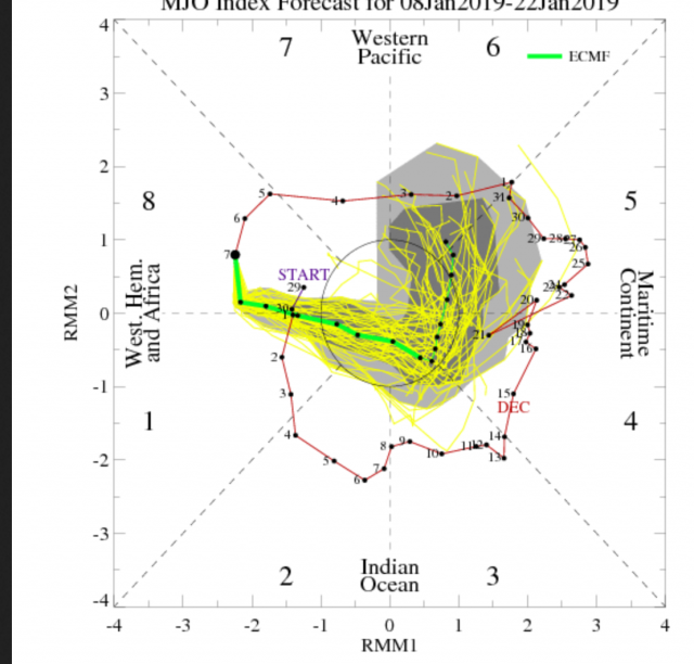
Its been a very frustrating winter, folks. And with Stratospheric mean zonal winds expected to go positive again and the MJO entering warm phases, I am concerned we may very well witness one of the worst winters (snowfall wise) of our lifetimes.
_________________
_______________________________________________________________________________________________________
CLICK HERE to view NJ Strong Snowstorm Classifications

Frank_Wx- Godzilla Seeker

- Posts : 21305
Reputation : 328
Join date : 2013-01-05
Age : 31
Location : Jersey City, NJ -

Re: Long Range Thread 18.0
![]() by heehaw453 Tue Jan 22, 2019 10:44 am
by heehaw453 Tue Jan 22, 2019 10:44 am
heehaw453- Advanced Forecaster
- Posts : 3906
Reputation : 86
Join date : 2014-01-20
Location : Bedminster Township, PA Elevation 600' ASL
Re: Long Range Thread 18.0
![]() by billg315 Tue Jan 22, 2019 10:50 am
by billg315 Tue Jan 22, 2019 10:50 am

billg315- Advanced Forecaster - Mod
- Posts : 4466
Reputation : 185
Join date : 2015-01-24
Age : 50
Location : Flemington, NJ
Re: Long Range Thread 18.0
![]() by HectorO Tue Jan 22, 2019 11:23 am
by HectorO Tue Jan 22, 2019 11:23 am
lglickman1 wrote:Does anyone see anything promising on the horizon? Or only false hopes and crushing defeat?
The horizon meaning next winter.

HectorO- Pro Enthusiast
- Posts : 959
Reputation : 27
Join date : 2013-01-11
Re: Long Range Thread 18.0
![]() by sroc4 Tue Jan 22, 2019 11:25 am
by sroc4 Tue Jan 22, 2019 11:25 am
_________________
"In weather and in life, there's no winning and losing; there's only winning and learning."
WINTER 2012/2013 TOTALS 43.65"WINTER 2017/2018 TOTALS 62.85" WINTER 2022/2023 TOTALS 4.9"
WINTER 2013/2014 TOTALS 64.85"WINTER 2018/2019 TOTALS 14.25" WINTER 2023/2024 TOTALS 13.1"
WINTER 2014/2015 TOTALS 71.20"WINTER 2019/2020 TOTALS 6.35"
WINTER 2015/2016 TOTALS 35.00"WINTER 2020/2021 TOTALS 37.75"
WINTER 2016/2017 TOTALS 42.25"WINTER 2021/2022 TOTALS 31.65"

sroc4- Admin
- Posts : 8331
Reputation : 301
Join date : 2013-01-07
Location : Wading River, LI
Re: Long Range Thread 18.0
![]() by amugs Tue Jan 22, 2019 11:47 am
by amugs Tue Jan 22, 2019 11:47 am

_________________
Mugs
AKA:King: Snow Weenie
Self Proclaimed
WINTER 2014-15 : 55.12" +.02 for 6 coatings (avg. 35")
WINTER 2015-16 Total - 29.8" (Avg 35")
WINTER 2016-17 : 39.5" so far
amugs- Advanced Forecaster - Mod
- Posts : 15093
Reputation : 213
Join date : 2013-01-07
Age : 54
Location : Hillsdale,NJ
Re: Long Range Thread 18.0
![]() by CPcantmeasuresnow Tue Jan 22, 2019 12:40 pm
by CPcantmeasuresnow Tue Jan 22, 2019 12:40 pm
amugs wrote:EPS the cold is here
No offense to you or any of the experts, but these maps a week or more out have become meaningless this winter.
CPcantmeasuresnow- Wx Statistician Guru
- Posts : 7274
Reputation : 230
Join date : 2013-01-07
Age : 103
Location : Eastern Orange County, NY
Re: Long Range Thread 18.0
![]() by amugs Tue Jan 22, 2019 2:09 pm
by amugs Tue Jan 22, 2019 2:09 pm
This pattern has been the same since early Dec and you know that nature loves to lock in patterns. We need NAO help or the WC ridge to slide further east east .
From JB and Scot brought this up about the MJO and where teh convection is - and it isnt suppose to dry out over the warm phases until.............next week now - for the love of god it was to be a slingshot run through these phases for 3-5 days now were are up to 10 days
.gif)
.png)
This though this jet streak looks good to me for Sunday into Monday on the GEFS overall - needs some work though


Need about 100 miles more south for my liking at this stage for everyone here to see snow

The Best storms pop up within the 5 day range so holding out over the next two days for this Sunday into Monday event.
As one met said we keep saying 7 days it will change adn the other factors come into play and squash us - ala the dismal winter 11-12 winter
_________________
Mugs
AKA:King: Snow Weenie
Self Proclaimed
WINTER 2014-15 : 55.12" +.02 for 6 coatings (avg. 35")
WINTER 2015-16 Total - 29.8" (Avg 35")
WINTER 2016-17 : 39.5" so far
amugs- Advanced Forecaster - Mod
- Posts : 15093
Reputation : 213
Join date : 2013-01-07
Age : 54
Location : Hillsdale,NJ
Re: Long Range Thread 18.0
![]() by dkodgis Tue Jan 22, 2019 3:12 pm
by dkodgis Tue Jan 22, 2019 3:12 pm
n-o-r-m-a-l
I don't wanna believe it

dkodgis- Senior Enthusiast
- Posts : 2501
Reputation : 98
Join date : 2013-12-29
Page 16 of 36 • 1 ... 9 ... 15, 16, 17 ... 26 ... 36 ![]()