
 Search
Long Range Thread 18.0
Page 22 of 36 •  1 ... 12 ... 21, 22, 23 ... 29 ... 36
 ![]()
Re: Long Range Thread 18.0
![]() by sroc4 Sun Feb 03, 2019 2:58 pm
by sroc4 Sun Feb 03, 2019 2:58 pm
CPcantmeasuresnow wrote:
Great post Doc, same question to you.
It seems to me this winter anytime the MJO enters phase 8 as brief as it is, it always seems to want to jump right into the COD and back to phase 4, bypassing Phase one and two completely. I'm, not sure I follow why you believe it will be different this time around. Also what are the chances we finally get a sustained +PNA?
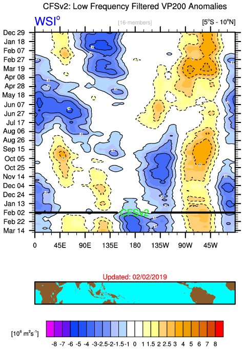
Hey Cp. Im not sure that I posted anything specific stating that I thought this time would be different. I simply pointed out that there are two different camps beyond the 5-7day time frame. Both camps show the emergenge of the -EPO in 5days+/-. Its what happens after where the divergence of solns occurs. As Mugs posted todays MJO forecast has the Euro with even more amplitude than yesterdays forecast, and GEFS indicates for the first time making it into 8 albeit still differently than how the euro gets it there.
I personally believe we see it come out in 8 more so like the Euro because of the way the euro handled the last trip from the MJO through phases 5, 6, and 7 before entering 8. You have a 100% valid point that in the prev trip through 8 it only lasted a very short time. Only about 7 days to be exact. The MJO has been in a favorale phase for a mere 7 days out of the last 30-35 or so. The rest of the days have been in the warm phases or the COD. Its hard to get anything going with such a short duration.
So why will it be different this time? Well I don't have specific reasoning, but I also am not realy making the claim. It very well may do a similar trip though 8 for a week +/- and come right back towards the warmer phase again. Im hoping not but who knows at this stage. The SSTA along the Pac and IO equator aren't all that diff now than in Jan, but I will say that seasonally and climatologically we are entering a different time frame than late dec into Jan. vs now we enter mid Feb(which is a short month) into early March.
All Im saying is that if we see it emerging out in 8 by next weekend the resistance to the east relaxes and our odds go back up. If it only lasts a week again we get a short window and have to hope the individual ingredients come together earlier this time. Last time it was in 8 for 1 week the ingredients came together for our storm, Jan 19th-20th, while it was already emerging out in 4 rather than the middle of 8. That set up we had the cold ahead of the system, but the resistance flexed because atmospherically it was already to do so as it reached our coast as it was in 4.
We'll see. First thing I wAnt to see is if we are coming out in 8 or not. Then Ill worry about for how long.
sroc4- Admin

- Posts : 8331
Join date : 2013-01-07
Re: Long Range Thread 18.0
![]() by sroc4 Sun Feb 03, 2019 3:05 pm
by sroc4 Sun Feb 03, 2019 3:05 pm
sroc4- Admin
- Posts : 8331
Join date : 2013-01-07
Re: Long Range Thread 18.0
![]() by mwilli5783 Sun Feb 03, 2019 3:12 pm
by mwilli5783 Sun Feb 03, 2019 3:12 pm
mwilli5783- Posts : 146
Reputation : 9
Join date : 2013-01-23
Age : 69
Location : hempstead n.y
Re: Long Range Thread 18.0
![]() by Guest Sun Feb 03, 2019 3:25 pm
by Guest Sun Feb 03, 2019 3:25 pm
Also thank you for showing wisdom. And officially throwing in the towel as I’ve done awhile ago now. Just doesn’t want to snow this winter. People
Keep searching for positives but don’t want to see the reality
God bless
Day 4

Day 5

Guest- Guest
Re: Long Range Thread 18.0
![]() by Snow88 Sun Feb 03, 2019 4:22 pm
by Snow88 Sun Feb 03, 2019 4:22 pm
syosnow94 wrote:Congratulations Frank. Well deserved
Also thank you for showing wisdom. And officially throwing in the towel as I’ve done awhile ago now. Just doesn’t want to snow this winter. People
Keep searching for positives but don’t want to see the reality
God bless
Day 4
Day 5
Throwing in the towel in early February? Many people did the same last winter and looked what happened. You posted the 5 day forecast which does show a brief warmup but that's not going to last. The MJO on the Euro,EPS,GEFS and GFS all show it going into 8 and possibly 1 which are favorable phases for the east. The latest EPS is really gung ho on a strong -EPO ridge which would bold well for cold air for our region. Does that mean snow? No but it makes the pattern more favorable for snow.
Just compare the 0z and 12z runs today. The EPO press is more on todays 12z run. If the MJO is correct on both models, expect the operational models to trend southward with the storms . Yes we will still be dealing with a -PNA ( which is why we need a -EPO to help us out here ) but we can still get wintry weather with those tellies like that.

Snow88- Senior Enthusiast

- Posts : 2193
Reputation : 4
Join date : 2013-01-09
Age : 35
Location : Brooklyn, NY
Re: Long Range Thread 18.0
![]() by Guest Sun Feb 03, 2019 4:23 pm
by Guest Sun Feb 03, 2019 4:23 pm
And our leader threw in as well
Guest- Guest
Re: Long Range Thread 18.0
![]() by Frank_Wx Mon Feb 04, 2019 6:39 am
by Frank_Wx Mon Feb 04, 2019 6:39 am
For the record - I did not throw in the towel on winter. I stated we would be done UNLESS the MJO pulls through, and that remains a possibility for a storm threat Sunday into Monday.
However, I do standby my comment that we're unlikely to reach our normal snowfall for those that live along the coast.
_________________
_______________________________________________________________________________________________________
CLICK HERE to view NJ Strong Snowstorm Classifications

Frank_Wx- Godzilla Seeker
- Posts : 21305
Reputation : 328
Join date : 2013-01-05
Age : 31
Location : Jersey City, NJ -

Re: Long Range Thread 18.0
![]() by heehaw453 Mon Feb 04, 2019 7:33 am
by heehaw453 Mon Feb 04, 2019 7:33 am
Frank_Wx wrote:Thank you everyone!
For the record - I did not throw in the towel on winter. I stated we would be done UNLESS the MJO pulls through, and that remains a possibility for a storm threat Sunday into Monday.
However, I do standby my comment that we're unlikely to reach our normal snowfall for those that live along the coast.
That's what i took out of your last write up. Completely agree, including March I'm almost certain that coastal sections aren't getting to norms this year. I'm less confident on that for more inland areas, but feel there's a pretty good chance of BN there too. Even if MJO goes into 8 and we get -EPO; how long does it stay there, what's its amplitude, where does it go? Too much has to go right and then there's the blocking aspect that really helps for bigger ticket items that has eluded us all winter. Moreover, you get these stinker winters every 4-5 years around here anyway which it's about due for one. Hope I'm dead wrong and it rocks after the 10th.
heehaw453- Advanced Forecaster

- Posts : 3906
Reputation : 86
Join date : 2014-01-20
Location : Bedminster Township, PA Elevation 600' ASL
Re: Long Range Thread 18.0
![]() by weatherwatchermom Mon Feb 04, 2019 8:14 am
by weatherwatchermom Mon Feb 04, 2019 8:14 am
Frank_Wx wrote:Thank you everyone!
For the record - I did not throw in the towel on winter. I stated we would be done UNLESS the MJO pulls through, and that remains a possibility for a storm threat Sunday into Monday.
However, I do standby my comment that we're unlikely to reach our normal snowfall for those that live along the coast.
CONGRATULATIONS FRANK!!

Not happy with the way winter is going..but thank you for giving us your view point...at this point I will be happy with just one storm!! the fact that we in this house went crazy with a 15 squall says a lot...lol..the video was too big for me to post...
Here's to at least one beast we can track and verify!!

weatherwatchermom- Senior Enthusiast
- Posts : 3742
Reputation : 77
Join date : 2014-11-25
Age : 60
Location : Hazlet Township, NJ
Re: Long Range Thread 18.0
![]() by Snow88 Mon Feb 04, 2019 5:57 pm
by Snow88 Mon Feb 04, 2019 5:57 pm
syosnow94 wrote:Snow I hope you’re correct. Trust me I do. But 3+ months OF THE SAME PATTERN tells me you won’t be
And our leader threw in as well
3 months of the MJO not being in phase 8-1 will do it.
The MJO will be traveling through the favorable phases and the EPO is going to be negative .
I wont be right? How do you know that?
Pattern recognition. You can give up but it's foolish .
Snow88- Senior Enthusiast
- Posts : 2193
Reputation : 4
Join date : 2013-01-09
Age : 35
Location : Brooklyn, NY
Re: Long Range Thread 18.0
![]() by Snow88 Mon Feb 04, 2019 5:59 pm
by Snow88 Mon Feb 04, 2019 5:59 pm
Snow88- Senior Enthusiast
- Posts : 2193
Reputation : 4
Join date : 2013-01-09
Age : 35
Location : Brooklyn, NY
Re: Long Range Thread 18.0
![]() by Guest Mon Feb 04, 2019 9:05 pm
by Guest Mon Feb 04, 2019 9:05 pm
Think about the promise and optimism back in the fall then repeat this....
Three full months without appreciable snow for 90% of this forum and people
Are still saying we can salvage winter? Yes it will snow again. Probably during the next month at some
Point. But even if it’s a Godzilla + this winter still sucks the big one. No amount of snow in the next month can change that.
Guest- Guest
Re: Long Range Thread 18.0
![]() by docstox12 Tue Feb 05, 2019 5:55 am
by docstox12 Tue Feb 05, 2019 5:55 am
Doc
https://seekingalpha.com/article/4237987-natural-gas-southeast-ridge-preventing-bullish-outlook

docstox12- Wx Statistician Guru

- Posts : 8504
Reputation : 222
Join date : 2013-01-07
Age : 73
Location : Monroe NY
Re: Long Range Thread 18.0
![]() by sroc4 Tue Feb 05, 2019 7:01 am
by sroc4 Tue Feb 05, 2019 7:01 am
docstox12 wrote:Question for the Long Range Crew.This source claims there is a possibility of the SE Ridge developing and mild conditions to persist.As a result Nat Gas prices have dropped sharply.Is this a probability or only a possibility? Thanks for anyone's help.
Doc
https://seekingalpha.com/article/4237987-natural-gas-southeast-ridge-preventing-bullish-outlook
Good morning Doc. Its not about the prospects of the SE developing; rather, will we see the continuation or persistence of. All the discussion about MJO in the warm phases and the "resistance" to the east is directly related to the western flank of the SE ridge flexing into the EC which has been discussed ad nauseum. Remember my discussion about the two camps going forward, GEFS vs EPS. EPS has the MJO into 8-1 in less than a week; whereas, the GEFS took it back around to 6-7(although now eventually has it out in 8; just takes much longer to get there). The result of the EPS was a developing and persistaing -EPO(ridge intothe Alaska region. The result of the GEFS would be a trough into the Alaska region and a more neutral to +EPO. The former drives the cold air S&E into the CONUS and NE vs the latter results in the trough west, rdidge east configuration.
The way I read the article is that while as a whole the market is going with what has happened thus far in that the SE ridge will likely persist; however, the articles author seems to see what I have been seeing in that the EPS model suite seems to be hinting at the colder soln possibly coming to fruition. Here are a couple of excerpts from the author:
Our view is that winter is not over yet despite the pessimistic view in the market.....
Our game plan will be to reenter the long position of tonight's ECMWF-EPS long-range confirms the bullish outlook for the 2nd half of February. We will need to monitor the Southeast ridge to see for signs of it going away. We know based on the recent models that if the SE ridge goes away, the forecast for cold returns to Northeast takes place, which would boost HDDs. We will be watching that closely.
Below is the image they used in the article. This is all 51 Euro ensemble members broken down into 3 camps. While the article focus' on the SE ridge, I would encourage you to look north into the high latitudes. Cluster 1 represents 22 of 51 members or 44%. Pay attention to the ridge placement SOUTH of Alaska(+EPO). If this soln was correct the southeast ridge will absolutely flex because the trough persists in the west, and the warmth and snowless winter continues. However, look at cluster 2 & 3 representing 16 members(32%) & 12members(24%) respectively. Notice both clusters have a ridge into Alaska (-EPO) and the 3rd cluster has a strong -NAO. While I don't necessarily believe the strength of the -NAO in cluster 3 if you combined/blend cluster 2&3 you get 56% of the members believing the -EPO will persist. IF that -EPO persists the trend will be to push the trough east and consequently push back the SE ridge back into the Atlantic.

If I were a man watching the trends in the market Doc Id be watching the trends to the MJO forecast, and the trends to the EPO region; NOT the SE ridge because its these two areas that will govern the SE ridge. If I cont to see the phase 8&1 region of he MJO coming to fruition sooner(later) on the forecasts and the EPO region trending persistently negative(positive) Id be buying low(high) as the models are notorious for playing catch up. As Ive said earlier by Wed/Thursday of this week the true trend to the EPS vs GEFS will begin to reveal itself. Now the duration at which the MJO persists in the cold phase would also guide me in my decisions in buying or selling and when to buy and sell. Obviously if the MJO does indeed traverse the cold phases, but does so for a short duration very quickly the cold shots will moderate once again.
_________________
"In weather and in life, there's no winning and losing; there's only winning and learning."
WINTER 2012/2013 TOTALS 43.65"WINTER 2017/2018 TOTALS 62.85" WINTER 2022/2023 TOTALS 4.9"
WINTER 2013/2014 TOTALS 64.85"WINTER 2018/2019 TOTALS 14.25" WINTER 2023/2024 TOTALS 13.1"
WINTER 2014/2015 TOTALS 71.20"WINTER 2019/2020 TOTALS 6.35"
WINTER 2015/2016 TOTALS 35.00"WINTER 2020/2021 TOTALS 37.75"
WINTER 2016/2017 TOTALS 42.25"WINTER 2021/2022 TOTALS 31.65"

sroc4- Admin
- Posts : 8331
Reputation : 301
Join date : 2013-01-07
Location : Wading River, LI
Re: Long Range Thread 18.0
![]() by sroc4 Tue Feb 05, 2019 7:11 am
by sroc4 Tue Feb 05, 2019 7:11 am
syosnow94 wrote:IREALLY DONT UNDERSTAND WHAT IS SO DIFFICULT TO UNDERSTAND.
Think about the promise and optimism back in the fall then repeat this....
Three full months without appreciable snow for 90% of this forum and people
Are still saying we can salvage winter? Yes it will snow again. Probably during the next month at some
Point. But even if it’s a Godzilla + this winter still sucks the big one. No amount of snow in the next month can change that.
Remember Jimmy this isn't about winning the game anymore. The game is a blow out; we are way to far behind. It now about if we can still show some fight in the last quarter such that we end on a positive note. We know how you feel. We've know how you feel for about 45days now. Now join the fight to end strong. No guarantees.
_________________
"In weather and in life, there's no winning and losing; there's only winning and learning."
WINTER 2012/2013 TOTALS 43.65"WINTER 2017/2018 TOTALS 62.85" WINTER 2022/2023 TOTALS 4.9"
WINTER 2013/2014 TOTALS 64.85"WINTER 2018/2019 TOTALS 14.25" WINTER 2023/2024 TOTALS 13.1"
WINTER 2014/2015 TOTALS 71.20"WINTER 2019/2020 TOTALS 6.35"
WINTER 2015/2016 TOTALS 35.00"WINTER 2020/2021 TOTALS 37.75"
WINTER 2016/2017 TOTALS 42.25"WINTER 2021/2022 TOTALS 31.65"
sroc4- Admin
- Posts : 8331
Reputation : 301
Join date : 2013-01-07
Location : Wading River, LI
Re: Long Range Thread 18.0
![]() by docstox12 Tue Feb 05, 2019 7:24 am
by docstox12 Tue Feb 05, 2019 7:24 am
sroc4 wrote:docstox12 wrote:Question for the Long Range Crew.This source claims there is a possibility of the SE Ridge developing and mild conditions to persist.As a result Nat Gas prices have dropped sharply.Is this a probability or only a possibility? Thanks for anyone's help.
Doc
https://seekingalpha.com/article/4237987-natural-gas-southeast-ridge-preventing-bullish-outlook
Good morning Doc. Its not about the prospects of the SE developing; rather, will we see the continuation or persistence of. All the discussion about MJO in the warm phases and the "resistance" to the east is directly related to the western flank of the SE ridge flexing into the EC which has been discussed ad nauseum. Remember my discussion about the two camps going forward, GEFS vs EPS. EPS has the MJO into 8-1 in less than a week; whereas, the GEFS took it back around to 6-7(although now eventually has it out in 8; just takes much longer to get there). The result of the EPS was a developing and persistaing -EPO(ridge intothe Alaska region. The result of the GEFS would be a trough into the Alaska region and a more neutral to +EPO. The former drives the cold air S&E into the CONUS and NE vs the latter results in the trough west, rdidge east configuration.
The way I read the article is that while as a whole the market is going with what has happened thus far in that the SE ridge will likely persist; however, the articles author seems to see what I have been seeing in that the EPS model suite seems to be hinting at the colder soln possibly coming to fruition. Here are a couple of excerpts from the author:
Our view is that winter is not over yet despite the pessimistic view in the market.....
Our game plan will be to reenter the long position of tonight's ECMWF-EPS long-range confirms the bullish outlook for the 2nd half of February. We will need to monitor the Southeast ridge to see for signs of it going away. We know based on the recent models that if the SE ridge goes away, the forecast for cold returns to Northeast takes place, which would boost HDDs. We will be watching that closely.
Below is the image they used in the article. This is all 51 Euro ensemble members broken down into 3 camps. While the article focus' on the SE ridge, I would encourage you to look north into the high latitudes. Cluster 1 represents 22 of 51 members or 44%. Pay attention to the ridge placement SOUTH of Alaska(+EPO). If this soln was correct the southeast ridge will absolutely flex because the trough persists in the west, and the warmth and snowless winter continues. However, look at cluster 2 & 3 representing 16 members(32%) & 12members(24%) respectively. Notice both clusters have a ridge into Alaska (-EPO) and the 3rd cluster has a strong -NAO. While I don't necessarily believe the strength of the -NAO in cluster 3 if you combined/blend cluster 2&3 you get 56% of the members believing the -EPO will persist. IF that -EPO persists the trend will be to push the trough east and consequently push back the SE ridge back into the Atlantic.
If I were a man watching the trends in the market Doc Id be watching the trends to the MJO forecast, and the trends to the EPO region; NOT the SE ridge because its these two areas that will govern the SE ridge. If I cont to see the phase 8&1 region of he MJO coming to fruition sooner(later) on the forecasts and the EPO region trending persistently negative(positive) Id be buying low(high) as the models are notorious for playing catch up. As Ive said earlier by Wed/Thursday of this week the true trend to the EPS vs GEFS will begin to reveal itself. Now the duration at which the MJO persists in the cold phase would also guide me in my decisions in buying or selling and when to buy and sell. Obviously if the MJO does indeed traverse the cold phases, but does so for a short duration very quickly the cold shots will moderate once again.
Doc, Thank you so much for taking the time to explain this analysis to me in detail.
It's very interesting to me how a trader can profit from the long range analysis you and others here so kindly and ably take the time to post.I successfully traded the UNG Nat Gas ETF just prior to the cold spell we made and made a nice profit.This same ETF has now dropped back into the low end of the trading range as a result of the negativity associated with the article I posted here.I'll watch the MJO and EPO trends as you suggest.
docstox12- Wx Statistician Guru
- Posts : 8504
Reputation : 222
Join date : 2013-01-07
Age : 73
Location : Monroe NY
Re: Long Range Thread 18.0
![]() by GreyBeard Tue Feb 05, 2019 11:16 am
by GreyBeard Tue Feb 05, 2019 11:16 am
docstox12 wrote:sroc4 wrote:docstox12 wrote:Question for the Long Range Crew.This source claims there is a possibility of the SE Ridge developing and mild conditions to persist.As a result Nat Gas prices have dropped sharply.Is this a probability or only a possibility? Thanks for anyone's help.
Doc
https://seekingalpha.com/article/4237987-natural-gas-southeast-ridge-preventing-bullish-outlook
Good morning Doc. Its not about the prospects of the SE developing; rather, will we see the continuation or persistence of. All the discussion about MJO in the warm phases and the "resistance" to the east is directly related to the western flank of the SE ridge flexing into the EC which has been discussed ad nauseum. Remember my discussion about the two camps going forward, GEFS vs EPS. EPS has the MJO into 8-1 in less than a week; whereas, the GEFS took it back around to 6-7(although now eventually has it out in 8; just takes much longer to get there). The result of the EPS was a developing and persistaing -EPO(ridge intothe Alaska region. The result of the GEFS would be a trough into the Alaska region and a more neutral to +EPO. The former drives the cold air S&E into the CONUS and NE vs the latter results in the trough west, rdidge east configuration.
The way I read the article is that while as a whole the market is going with what has happened thus far in that the SE ridge will likely persist; however, the articles author seems to see what I have been seeing in that the EPS model suite seems to be hinting at the colder soln possibly coming to fruition. Here are a couple of excerpts from the author:
Our view is that winter is not over yet despite the pessimistic view in the market.....
Our game plan will be to reenter the long position of tonight's ECMWF-EPS long-range confirms the bullish outlook for the 2nd half of February. We will need to monitor the Southeast ridge to see for signs of it going away. We know based on the recent models that if the SE ridge goes away, the forecast for cold returns to Northeast takes place, which would boost HDDs. We will be watching that closely.
Below is the image they used in the article. This is all 51 Euro ensemble members broken down into 3 camps. While the article focus' on the SE ridge, I would encourage you to look north into the high latitudes. Cluster 1 represents 22 of 51 members or 44%. Pay attention to the ridge placement SOUTH of Alaska(+EPO). If this soln was correct the southeast ridge will absolutely flex because the trough persists in the west, and the warmth and snowless winter continues. However, look at cluster 2 & 3 representing 16 members(32%) & 12members(24%) respectively. Notice both clusters have a ridge into Alaska (-EPO) and the 3rd cluster has a strong -NAO. While I don't necessarily believe the strength of the -NAO in cluster 3 if you combined/blend cluster 2&3 you get 56% of the members believing the -EPO will persist. IF that -EPO persists the trend will be to push the trough east and consequently push back the SE ridge back into the Atlantic.
If I were a man watching the trends in the market Doc Id be watching the trends to the MJO forecast, and the trends to the EPO region; NOT the SE ridge because its these two areas that will govern the SE ridge. If I cont to see the phase 8&1 region of he MJO coming to fruition sooner(later) on the forecasts and the EPO region trending persistently negative(positive) Id be buying low(high) as the models are notorious for playing catch up. As Ive said earlier by Wed/Thursday of this week the true trend to the EPS vs GEFS will begin to reveal itself. Now the duration at which the MJO persists in the cold phase would also guide me in my decisions in buying or selling and when to buy and sell. Obviously if the MJO does indeed traverse the cold phases, but does so for a short duration very quickly the cold shots will moderate once again.
Doc, Thank you so much for taking the time to explain this analysis to me in detail.
It's very interesting to me how a trader can profit from the long range analysis you and others here so kindly and ably take the time to post.I successfully traded the UNG Nat Gas ETF just prior to the cold spell we made and made a nice profit.This same ETF has now dropped back into the low end of the trading range as a result of the negativity associated with the article I posted here.I'll watch the MJO and EPO trends as you suggest.
You'll have to start posting some stock tips so we can all cash in,Doc. Remember,sharing is caring.
GreyBeard- Senior Enthusiast
- Posts : 725
Reputation : 34
Join date : 2014-02-12
Location : eastern nassau county
Re: Long Range Thread 18.0
![]() by docstox12 Tue Feb 05, 2019 11:57 am
by docstox12 Tue Feb 05, 2019 11:57 am
GreyBeard wrote:docstox12 wrote:sroc4 wrote:docstox12 wrote:Question for the Long Range Crew.This source claims there is a possibility of the SE Ridge developing and mild conditions to persist.As a result Nat Gas prices have dropped sharply.Is this a probability or only a possibility? Thanks for anyone's help.
Doc
https://seekingalpha.com/article/4237987-natural-gas-southeast-ridge-preventing-bullish-outlook
Good morning Doc. Its not about the prospects of the SE developing; rather, will we see the continuation or persistence of. All the discussion about MJO in the warm phases and the "resistance" to the east is directly related to the western flank of the SE ridge flexing into the EC which has been discussed ad nauseum. Remember my discussion about the two camps going forward, GEFS vs EPS. EPS has the MJO into 8-1 in less than a week; whereas, the GEFS took it back around to 6-7(although now eventually has it out in 8; just takes much longer to get there). The result of the EPS was a developing and persistaing -EPO(ridge intothe Alaska region. The result of the GEFS would be a trough into the Alaska region and a more neutral to +EPO. The former drives the cold air S&E into the CONUS and NE vs the latter results in the trough west, rdidge east configuration.
The way I read the article is that while as a whole the market is going with what has happened thus far in that the SE ridge will likely persist; however, the articles author seems to see what I have been seeing in that the EPS model suite seems to be hinting at the colder soln possibly coming to fruition. Here are a couple of excerpts from the author:
Our view is that winter is not over yet despite the pessimistic view in the market.....
Our game plan will be to reenter the long position of tonight's ECMWF-EPS long-range confirms the bullish outlook for the 2nd half of February. We will need to monitor the Southeast ridge to see for signs of it going away. We know based on the recent models that if the SE ridge goes away, the forecast for cold returns to Northeast takes place, which would boost HDDs. We will be watching that closely.
Below is the image they used in the article. This is all 51 Euro ensemble members broken down into 3 camps. While the article focus' on the SE ridge, I would encourage you to look north into the high latitudes. Cluster 1 represents 22 of 51 members or 44%. Pay attention to the ridge placement SOUTH of Alaska(+EPO). If this soln was correct the southeast ridge will absolutely flex because the trough persists in the west, and the warmth and snowless winter continues. However, look at cluster 2 & 3 representing 16 members(32%) & 12members(24%) respectively. Notice both clusters have a ridge into Alaska (-EPO) and the 3rd cluster has a strong -NAO. While I don't necessarily believe the strength of the -NAO in cluster 3 if you combined/blend cluster 2&3 you get 56% of the members believing the -EPO will persist. IF that -EPO persists the trend will be to push the trough east and consequently push back the SE ridge back into the Atlantic.
If I were a man watching the trends in the market Doc Id be watching the trends to the MJO forecast, and the trends to the EPO region; NOT the SE ridge because its these two areas that will govern the SE ridge. If I cont to see the phase 8&1 region of he MJO coming to fruition sooner(later) on the forecasts and the EPO region trending persistently negative(positive) Id be buying low(high) as the models are notorious for playing catch up. As Ive said earlier by Wed/Thursday of this week the true trend to the EPS vs GEFS will begin to reveal itself. Now the duration at which the MJO persists in the cold phase would also guide me in my decisions in buying or selling and when to buy and sell. Obviously if the MJO does indeed traverse the cold phases, but does so for a short duration very quickly the cold shots will moderate once again.
Doc, Thank you so much for taking the time to explain this analysis to me in detail.
It's very interesting to me how a trader can profit from the long range analysis you and others here so kindly and ably take the time to post.I successfully traded the UNG Nat Gas ETF just prior to the cold spell we made and made a nice profit.This same ETF has now dropped back into the low end of the trading range as a result of the negativity associated with the article I posted here.I'll watch the MJO and EPO trends as you suggest.
You'll have to start posting some stock tips so we can all cash in,Doc. Remember,sharing is caring.
LOL, but if my tips crap out I get banned from here, especially if a moderator loses money.I'll be happy to reference my Bibliography of technical analysis and my internet sources of information so anybody can study and learn to do what I do!
docstox12- Wx Statistician Guru
- Posts : 8504
Reputation : 222
Join date : 2013-01-07
Age : 73
Location : Monroe NY
Re: Long Range Thread 18.0
![]() by amugs Tue Feb 05, 2019 1:05 pm
by amugs Tue Feb 05, 2019 1:05 pm
Those that are betting with the Groundhog may get burned badly from what is being progged by models and actually WV loops these last two days.
The guidance is moving in a positive direction and we are going to see this warmth period which is always the case with PV intrusions and exits - much different than Negative EPO sustainability due to a warm blob that just feedback's on itself.
From Armando who is one of our own here:

Squared area is the convection or wave that is indicated on brown on the chart above

Yuo see the wave at the dateline in brown - that is where teh convection is firing which will prog the MJO plots to become more amplified as teh wave travels westward = WWB. This will cause the area behind it to rise in pressure and cause the pressures east of it to drop thus helping tank the SOI index. The upstream effects will help the EPO anchor and thus promote a more Positive PNA ridge than what we are seeing now. This will beta back the SE Ridge and hold it bay.
GEFS are wildly strong for their wave and the maps dont align to this wave in the period it is forecasting this

EURO pretty strong wave
EMON is drool worthy for a MJO plot this time of year hitting tHE cold and stormy phases

I PRAY THIS MJO PLOT VERIFIES!! If it would be able to give us about a 30 day period of cold and snow chances.
That's all for now, maps will come around to this evolution over this week.
_________________
Mugs
AKA:King: Snow Weenie
Self Proclaimed
WINTER 2014-15 : 55.12" +.02 for 6 coatings (avg. 35")
WINTER 2015-16 Total - 29.8" (Avg 35")
WINTER 2016-17 : 39.5" so far

amugs- Advanced Forecaster - Mod

- Posts : 15093
Reputation : 213
Join date : 2013-01-07
Age : 54
Location : Hillsdale,NJ
Re: Long Range Thread 18.0
![]() by docstox12 Tue Feb 05, 2019 2:09 pm
by docstox12 Tue Feb 05, 2019 2:09 pm
amugs wrote:Doc,
Those that are betting with the Groundhog may get burned badly from what is being progged by models and actually WV loops these last two days.
The guidance is moving in a positive direction and we are going to see this warmth period which is always the case with PV intrusions and exits - much different than Negative EPO sustainability due to a warm blob that just feedback's on itself.
From Armando who is one of our own here:
Squared area is the convection or wave that is indicated on brown on the chart above
Yuo see the wave at the dateline in brown - that is where teh convection is firing which will prog the MJO plots to become more amplified as teh wave travels westward = WWB. This will cause the area behind it to rise in pressure and cause the pressures east of it to drop thus helping tank the SOI index. The upstream effects will help the EPO anchor and thus promote a more Positive PNA ridge than what we are seeing now. This will beta back the SE Ridge and hold it bay.
GEFS are wildly strong for their wave and the maps dont align to this wave in the period it is forecasting this
EURO pretty strong wave
EMON is drool worthy for a MJO plot this time of year hitting tHE cold and stormy phases
I PRAY THIS MJO PLOT VERIFIES!! If it would be able to give us about a 30 day period of cold and snow chances.
That's all for now, maps will come around to this evolution over this week.
Thank you Mugsy for taking the time to post this.It's very helpful!
docstox12- Wx Statistician Guru
- Posts : 8504
Reputation : 222
Join date : 2013-01-07
Age : 73
Location : Monroe NY
Re: Long Range Thread 18.0
![]() by heehaw453 Tue Feb 05, 2019 2:20 pm
by heehaw453 Tue Feb 05, 2019 2:20 pm

heehaw453- Advanced Forecaster
- Posts : 3906
Reputation : 86
Join date : 2014-01-20
Location : Bedminster Township, PA Elevation 600' ASL
Re: Long Range Thread 18.0
![]() by heehaw453 Tue Feb 05, 2019 5:26 pm
by heehaw453 Tue Feb 05, 2019 5:26 pm

heehaw453- Advanced Forecaster
- Posts : 3906
Reputation : 86
Join date : 2014-01-20
Location : Bedminster Township, PA Elevation 600' ASL
Re: Long Range Thread 18.0
![]() by Guest Tue Feb 05, 2019 5:30 pm
by Guest Tue Feb 05, 2019 5:30 pm
heehaw453 wrote:Latest GFS much closer to Euro with even a much stronger high pressure to north pressing down and not allowing the low to run inland. If this thing is any where near being correct it could even suppress the moisture. I'm feeling better about a non soaker and better about wintry potential on this ATTM. Long way to go unfortunately
Long way out but that SCREAMS strung out and suppressed like every other storm that stayed south of us this year. Either that or cutter
Guest- Guest
Re: Long Range Thread 18.0
![]() by heehaw453 Tue Feb 05, 2019 5:42 pm
by heehaw453 Tue Feb 05, 2019 5:42 pm
syosnow94 wrote:heehaw453 wrote:Latest GFS much closer to Euro with even a much stronger high pressure to north pressing down and not allowing the low to run inland. If this thing is any where near being correct it could even suppress the moisture. I'm feeling better about a non soaker and better about wintry potential on this ATTM. Long way to go unfortunately
Long way out but that SCREAMS strung out and suppressed like every other storm that stayed south of us this year. Either that or cutter
LOL! I know, believe me all with a grain of salt for now, but it does have my interest somewhat. Sometimes these overrunning events can render decent snows just as good as the nor'easters.
heehaw453- Advanced Forecaster
- Posts : 3906
Reputation : 86
Join date : 2014-01-20
Location : Bedminster Township, PA Elevation 600' ASL
Re: Long Range Thread 18.0
![]() by Frank_Wx Tue Feb 05, 2019 6:14 pm
by Frank_Wx Tue Feb 05, 2019 6:14 pm
It looks like guidance trended favorably for a possible storm next week. Timing appears to be Monday into Tuesday but that could change to Tuesday into Wednesday. After some rain late Thursday into Friday cold air settles back in this weekend. The question then becomes what does this energy over the southwest region of the U.S. do? If it all works out then we'll have a storm to track for early to mid next week.

As we move into next Tuesday morning this energy has drifted north near the TN Valley and you can see a potent piece of Pacific energy trying to phase into it.

Normally, this means a storm cutting to our west and we end up on the warm side of things. With how this winter has gone it would not shock me. HOWEVER, this time we see a primary low pressure cutting to our west but a secondary low (Miller B) forming off the coast. Check out the 534 ddm High Pressure in SE Canada. If that is REAL, BIG IF, then this has a good shot of playing out in our favor.


Right now I have VERY low confidence this does play out. The PNA/EPO regions do not look right to me. The MJO is also looking a little wonky. It is returning to phase 6 then moving into low amplitude phase 7 and eventually 8 - but this keeps changing every day.

IF the phase 7 and then 8 is real - and based off this Hovmoller you can see WWB (westerly wind bursts) at 180 (Dateline) beginning around the 10th which points to YES it could be real - then we should see the PNA/EPO regions improve in future model runs for this time period.
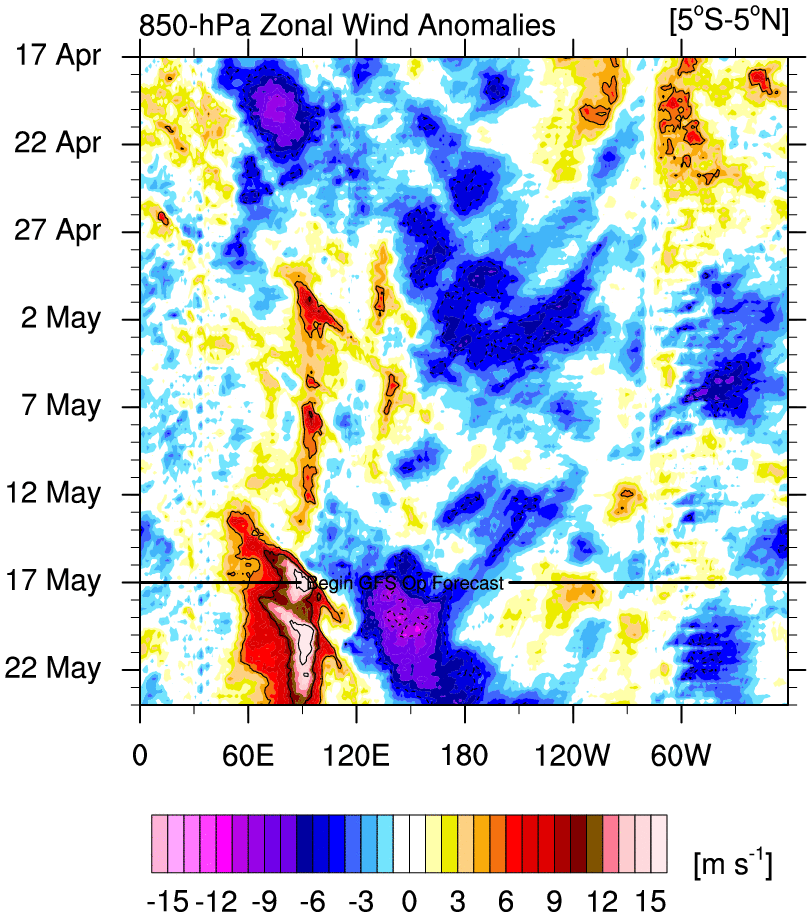
So - the chance of a storm does exist. My confidence is low. But it would get higher if the WWB at the Dateline are real, meaning the MJO will in fact move into phases 7 and 8 by early next week. If it does not, then we will see either a warm solution or something that looks suppressed / very minor.
Here is the thing. Long range forecasters have been bit many times this winter. Their guess is as good as mine what the MJO actually decides to do. So my suggestion is take a break. Look at the models again Friday or Saturday. Too many changes will happen over the next few days. AND - if you are going to make the choice and look at models every day, please post your complains in the BANTER thread. Leave this thread for real discussion.
Talk to everyone again on Monday. Ciao!
_________________
_______________________________________________________________________________________________________
CLICK HERE to view NJ Strong Snowstorm Classifications
Frank_Wx- Godzilla Seeker
- Posts : 21305
Reputation : 328
Join date : 2013-01-05
Age : 31
Location : Jersey City, NJ -
Re: Long Range Thread 18.0
![]() by jmanley32 Tue Feb 05, 2019 8:01 pm
by jmanley32 Tue Feb 05, 2019 8:01 pm

jmanley32- Senior Enthusiast
- Posts : 20516
Reputation : 108
Join date : 2013-12-12
Age : 42
Location : Yonkers, NY
Page 22 of 36 • 1 ... 12 ... 21, 22, 23 ... 29 ... 36 ![]()