
 Search
Long Range Thread 19.0
Page 1 of 28 • 1, 2, 3 ... 14 ... 28 ![]()

Long Range Thread 19.0
![]() by Frank_Wx Mon Oct 14, 2019 2:31 pm
by Frank_Wx Mon Oct 14, 2019 2:31 pm
In the early going the bulk of the discussion will be centered around the QBO, ENSO, AAM, and North America Snow Cover. These are the main 4 drivers of our weather pattern in my personal opinion. Then there are several things that enhance the pattern, like the teleconnections (AO, NAO, PNA) and the MJO being of most significance. For the purpose of just getting started and trying to get back into the swing of things, here is a brief update on some of these influencers.
The QBO measures easterly (positive) or westerly (negative) winds in the Stratosphere and often has direct influence on our sensible weather here in the Troposphere.
.png.18bd91d7846aab95cbdb36ec2ff83053.png)
Last winter many came to the conclusion the reason for lack of snowfall and warmer than normal temperatures was in part due to the negative QBO. However, if you remember we saw a very early Stratospheric Warming Event around Thanksgiving. At the time, many felt an early start to winter would happen in mid-December. No matter how much the Stratospheric PV was purturbed and displaced off the Arctic, the overall conditions in the Troposphere were not responding and many attributed that to the decoupling of the MJO - it never responded to what historically would happen in phases 7-8-1 - and the very anomalous -QBO (record low levels).
This image nicely shows how the QBO has trended from a westerly to easterly phase. In my research this is the first Fall the QBO has been positive since 2017. I'll be transparent and say I am not sure exactly what this could mean for us, but I will say it's refreshing to see a signal get out of a very anomalous (very negative) phase and normalize a bit. Normal can only mean better, right?

The global sea surface anomaly temperature map looks very very good for those seeking colder than normal weather. The ENSO region looks Modoki-like, which means the Dateline or central region of the ENSO (region 3.4) is the warmest region of them all. Central warming along the equatorial Pacific promotes convection which promotes ridging to occur near the EPO/PNA regions. A Modoki El Nino is on the table this winter and one we'll have to keep an eye on. Also, there is significant warmth found in the north-central Pacific and near Greenland. If these temps hold true there could be plenty of high latitude blocking that tries to develop this winter.
There is a lot more to look at. I'll have more either today or later this week.
_________________
_______________________________________________________________________________________________________
CLICK HERE to view NJ Strong Snowstorm Classifications

Frank_Wx- Godzilla Seeker

- Posts : 21305
Reputation : 328
Join date : 2013-01-05
Age : 31
Location : Jersey City, NJ -

Re: Long Range Thread 19.0
![]() by amugs Mon Oct 14, 2019 4:06 pm
by amugs Mon Oct 14, 2019 4:06 pm
Love the SST look, the QBO at 50,30 look good and slowly transgressing to a normal range and easterly direction possible that historically analogues shows a more favorable winter ala 1962-63,84-85,09 -10,02-03 and dare I say 95-96. Time will tell.
_________________
Mugs
AKA:King: Snow Weenie
Self Proclaimed
WINTER 2014-15 : 55.12" +.02 for 6 coatings (avg. 35")
WINTER 2015-16 Total - 29.8" (Avg 35")
WINTER 2016-17 : 39.5" so far

amugs- Advanced Forecaster - Mod

- Posts : 15093
Reputation : 213
Join date : 2013-01-07
Age : 54
Location : Hillsdale,NJ
Re: Long Range Thread 19.0
![]() by mwilli Wed Oct 16, 2019 10:42 am
by mwilli Wed Oct 16, 2019 10:42 am
mwilli- Posts : 132
Reputation : 3
Join date : 2019-02-11
Re: Long Range Thread 19.0
![]() by amugs Thu Oct 17, 2019 1:34 pm
by amugs Thu Oct 17, 2019 1:34 pm
Impacts gonna be here for some time
_________________
Mugs
AKA:King: Snow Weenie
Self Proclaimed
WINTER 2014-15 : 55.12" +.02 for 6 coatings (avg. 35")
WINTER 2015-16 Total - 29.8" (Avg 35")
WINTER 2016-17 : 39.5" so far
amugs- Advanced Forecaster - Mod
- Posts : 15093
Reputation : 213
Join date : 2013-01-07
Age : 54
Location : Hillsdale,NJ
Re: Long Range Thread 19.0
![]() by Frank_Wx Fri Oct 18, 2019 11:07 am
by Frank_Wx Fri Oct 18, 2019 11:07 am

The deep cold anomalies in western Canada down into the Great Lakes suggest La Nina base pattern. Indeed that was the case. The lack of PNA ridging at the time kept the major cold off to our N&W.

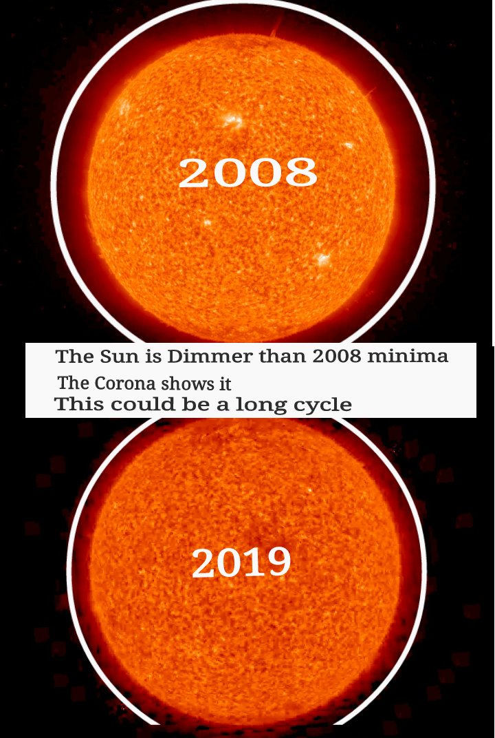
Obviously this year is different. We're headed toward a solar minimum with an ENSO base state of neutral to El Nino (maybe Modoki). That could push those deep cold anomalies into our region.
_________________
_______________________________________________________________________________________________________
CLICK HERE to view NJ Strong Snowstorm Classifications
Frank_Wx- Godzilla Seeker
- Posts : 21305
Reputation : 328
Join date : 2013-01-05
Age : 31
Location : Jersey City, NJ -
Re: Long Range Thread 19.0
![]() by Frank_Wx Fri Oct 18, 2019 11:11 am
by Frank_Wx Fri Oct 18, 2019 11:11 am


The above normal temps in the PAC NW and again in Maine suggest severe high latitude blocking (-EPO/-NAO). Hopefully not so severe it actually crushes our storms to the south. The above normal shown in Florida means a SE Ridge tries to also develop (El Nino base state) so storms will have a path right up the coastline. Right now, I think the DC-PHL region are in this winters cross hairs based off what I'm seeing.
_________________
_______________________________________________________________________________________________________
CLICK HERE to view NJ Strong Snowstorm Classifications
Frank_Wx- Godzilla Seeker
- Posts : 21305
Reputation : 328
Join date : 2013-01-05
Age : 31
Location : Jersey City, NJ -
Re: Long Range Thread 19.0
![]() by Frank_Wx Fri Oct 18, 2019 11:29 am
by Frank_Wx Fri Oct 18, 2019 11:29 am
http://www.bom.gov.au/climate/iod/
Check out the SSTA's in the IO right now:
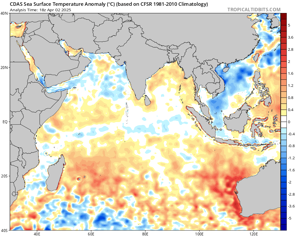
This is a signature +IOD look. Read their latest analysis here:
http://www.bom.gov.au/climate/enso/#tabs=Indian-Ocean
Last time we saw a +IOD of at least +1 degrees in the Fall and saw it crash into the negatives was winter of 2015-2016.

The outlook this year also shows a crash by the time we get to January.
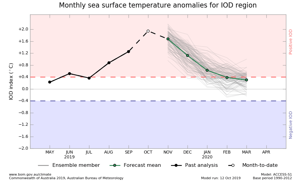
January 2016 CPK saw about 28" of snow.
_________________
_______________________________________________________________________________________________________
CLICK HERE to view NJ Strong Snowstorm Classifications
Frank_Wx- Godzilla Seeker
- Posts : 21305
Reputation : 328
Join date : 2013-01-05
Age : 31
Location : Jersey City, NJ -
Re: Long Range Thread 19.0
![]() by Frank_Wx Fri Oct 18, 2019 11:39 am
by Frank_Wx Fri Oct 18, 2019 11:39 am

_________________
_______________________________________________________________________________________________________
CLICK HERE to view NJ Strong Snowstorm Classifications
Frank_Wx- Godzilla Seeker
- Posts : 21305
Reputation : 328
Join date : 2013-01-05
Age : 31
Location : Jersey City, NJ -
Re: Long Range Thread 19.0
![]() by amugs Fri Oct 18, 2019 1:30 pm
by amugs Fri Oct 18, 2019 1:30 pm
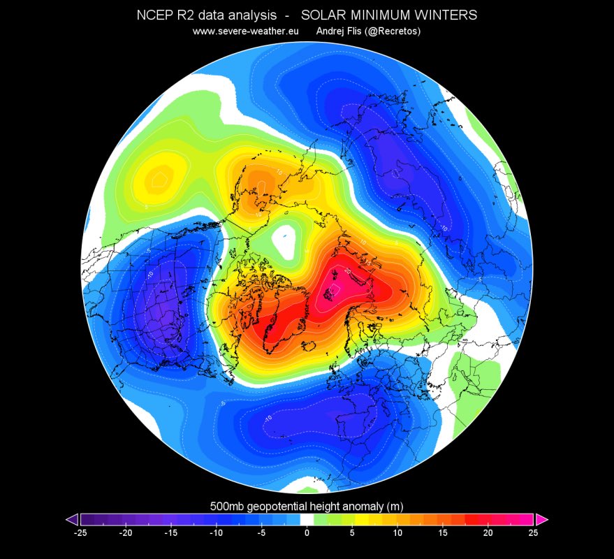
Here is the interesting reconstructed 500MB map - Warm Arctic region with blocking over teh top forcing the cold arctic air southward,
Where do I sign for this for winter??
_________________
Mugs
AKA:King: Snow Weenie
Self Proclaimed
WINTER 2014-15 : 55.12" +.02 for 6 coatings (avg. 35")
WINTER 2015-16 Total - 29.8" (Avg 35")
WINTER 2016-17 : 39.5" so far
amugs- Advanced Forecaster - Mod
- Posts : 15093
Reputation : 213
Join date : 2013-01-07
Age : 54
Location : Hillsdale,NJ
Re: Long Range Thread 19.0
![]() by Frank_Wx Fri Oct 18, 2019 2:30 pm
by Frank_Wx Fri Oct 18, 2019 2:30 pm
_________________
_______________________________________________________________________________________________________
CLICK HERE to view NJ Strong Snowstorm Classifications
Frank_Wx- Godzilla Seeker
- Posts : 21305
Reputation : 328
Join date : 2013-01-05
Age : 31
Location : Jersey City, NJ -
Re: Long Range Thread 19.0
![]() by HectorO Fri Oct 18, 2019 11:45 pm
by HectorO Fri Oct 18, 2019 11:45 pm
Frank_Wx wrote:The possible coastal storm next week is still showing on the models. Right now, confidence is low on any snow for our area because 500mb looks kinda crappy. But let's see what model runs this weekend show.
God please no. No snow in October, we know where that road leads.

HectorO- Pro Enthusiast

- Posts : 959
Reputation : 27
Join date : 2013-01-11
Re: Long Range Thread 19.0
![]() by docstox12 Sat Oct 19, 2019 6:17 am
by docstox12 Sat Oct 19, 2019 6:17 am

docstox12- Wx Statistician Guru

- Posts : 8502
Reputation : 222
Join date : 2013-01-07
Age : 73
Location : Monroe NY
Re: Long Range Thread 19.0
![]() by amugs Sat Oct 19, 2019 8:53 am
by amugs Sat Oct 19, 2019 8:53 am
Mugs"stradamous" looking into his snow weenie globe ays 1st week of Nov for NNJ to see some snow and stickage. NYC maybe snow but stickage is a crapshoot.

_________________
Mugs
AKA:King: Snow Weenie
Self Proclaimed
WINTER 2014-15 : 55.12" +.02 for 6 coatings (avg. 35")
WINTER 2015-16 Total - 29.8" (Avg 35")
WINTER 2016-17 : 39.5" so far
amugs- Advanced Forecaster - Mod
- Posts : 15093
Reputation : 213
Join date : 2013-01-07
Age : 54
Location : Hillsdale,NJ
Re: Long Range Thread 19.0
![]() by algae888 Wed Oct 23, 2019 8:42 am
by algae888 Wed Oct 23, 2019 8:42 am

algae888- Advanced Forecaster

- Posts : 5311
Reputation : 46
Join date : 2013-02-05
Age : 61
Location : mt. vernon, new york
Re: Long Range Thread 19.0
![]() by Snow88 Wed Oct 23, 2019 9:10 am
by Snow88 Wed Oct 23, 2019 9:10 am
algae888 wrote:Looks like a big fail by the models with the alleged Cold Shot coming last week of October into the first week of November. The Ridge in the EPO region is not orientated favorably and is super strong so that energy instead of coming east is dropping down into the Southwest causing the South East Ridge to pop. This is eerily similar to last winter when the 10 plus day guidance showed a favorable pattern coming but never materialized. I will say there is a big difference between the EPs and the GEFS. The latter brings the cold in here day6 the former not till day 10. So my take that it comes in day 8 and not as cold as was once thought as the GFS is usually too fast and the Euro usually holds back energy in the Southwest. So look for above normal temperatures for the next week or so
It's fine because the cold can wait until mid to late November

Snow88- Senior Enthusiast

- Posts : 2193
Reputation : 4
Join date : 2013-01-09
Age : 35
Location : Brooklyn, NY
Re: Long Range Thread 19.0
![]() by dkodgis Thu Oct 24, 2019 6:31 pm
by dkodgis Thu Oct 24, 2019 6:31 pm

dkodgis- Senior Enthusiast
- Posts : 2493
Reputation : 98
Join date : 2013-12-29
Re: Long Range Thread 19.0
![]() by billg315 Sat Oct 26, 2019 2:36 pm
by billg315 Sat Oct 26, 2019 2:36 pm

billg315- Advanced Forecaster - Mod
- Posts : 4462
Reputation : 185
Join date : 2015-01-24
Age : 50
Location : Flemington, NJ
Re: Long Range Thread 19.0
![]() by jmanley32 Sat Oct 26, 2019 8:34 pm
by jmanley32 Sat Oct 26, 2019 8:34 pm
Also showed on 06z, and again on 12z both were 6+ and o6z was a godzilla and bullseye was immediate NYC area, highly doubt it but it happened Nov. 17th last year 7 inches here in Yonkers and a disaster as you all remember areawide but yonkers had the most chaos.billg315 wrote:Almost hope it fizzles because a November snowstorm did not bode well for us last year . . . but the last GFS run is showing our first snowstorm of the year on Sunday, November 10. Still in fantasy-land so it could vanish by the next run, but worth noting only because we've all been waiting for that first glimpse of an area-wide snow event on the models.

jmanley32- Senior Enthusiast
- Posts : 20512
Reputation : 108
Join date : 2013-12-12
Age : 42
Location : Yonkers, NY
Re: Long Range Thread 19.0
![]() by amugs Sun Oct 27, 2019 9:27 am
by amugs Sun Oct 27, 2019 9:27 am

_________________
Mugs
AKA:King: Snow Weenie
Self Proclaimed
WINTER 2014-15 : 55.12" +.02 for 6 coatings (avg. 35")
WINTER 2015-16 Total - 29.8" (Avg 35")
WINTER 2016-17 : 39.5" so far
amugs- Advanced Forecaster - Mod
- Posts : 15093
Reputation : 213
Join date : 2013-01-07
Age : 54
Location : Hillsdale,NJ
Re: Long Range Thread 19.0
![]() by amugs Sun Oct 27, 2019 9:34 am
by amugs Sun Oct 27, 2019 9:34 am


SST - Modoki EL Nino looking good Regio 1.2 cooler - much cooler than 3.4 and 4 regions which will enhance yuor vertical lift, t-storms and drive the MJO in phase 8-1-2- which pronounces a trough over the NE.


13-14/14-15 look to SST's with teh blob in he NE PAC up by the Gulf of Alaska
This will enhance the Gulf of Alaskan LP and create the N EPO which is a pacific block and help enhance the Meridional Flow (Jet stream) - buckling of the jet so you get cold air to pour in from the arctic polar regions and an active storm track
_________________
Mugs
AKA:King: Snow Weenie
Self Proclaimed
WINTER 2014-15 : 55.12" +.02 for 6 coatings (avg. 35")
WINTER 2015-16 Total - 29.8" (Avg 35")
WINTER 2016-17 : 39.5" so far
amugs- Advanced Forecaster - Mod
- Posts : 15093
Reputation : 213
Join date : 2013-01-07
Age : 54
Location : Hillsdale,NJ
Re: Long Range Thread 19.0
![]() by Frank_Wx Sun Oct 27, 2019 10:53 am
by Frank_Wx Sun Oct 27, 2019 10:53 am

Beyond SSTA's we still have to pay close attention to our northern friend...the Stratosphere.

If latest forecasts are to be believed zonal winds in the Stratosphere are headed positive, an indication the PV will be strong over the Arctic to start out the winter.
Mike Ventrice said its actually stronger than normal for this time of year.
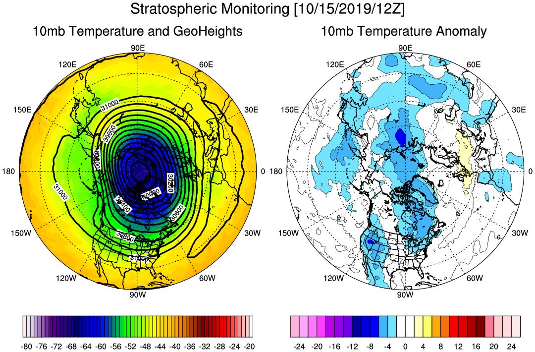
This is not abnormal. The SPV has to be stronger in the beginning of the winter. As we move into late December we hope to see the SPV weaken and undergo a SSW (sudden stratospheric warming). That's the point at which the TPV (tropospheric polar vortex) also becomes susceptible to disruption (-AO/-NAO). We don't want to see the SPV get too strong or it could delay the pattern change to sustained cold/snowy conditions in our area. However the image posted above is just a forecast from the GFS. Not paying much attention to it now.
_________________
_______________________________________________________________________________________________________
CLICK HERE to view NJ Strong Snowstorm Classifications
Frank_Wx- Godzilla Seeker
- Posts : 21305
Reputation : 328
Join date : 2013-01-05
Age : 31
Location : Jersey City, NJ -
Re: Long Range Thread 19.0
![]() by Frank_Wx Sun Oct 27, 2019 9:59 pm
by Frank_Wx Sun Oct 27, 2019 9:59 pm

SPV will be stronger than normal to start out the winter. Any SSW will take place toward Christmas IMO.
_________________
_______________________________________________________________________________________________________
CLICK HERE to view NJ Strong Snowstorm Classifications
Frank_Wx- Godzilla Seeker
- Posts : 21305
Reputation : 328
Join date : 2013-01-05
Age : 31
Location : Jersey City, NJ -
Re: Long Range Thread 19.0
![]() by aiannone Sun Oct 27, 2019 10:01 pm
by aiannone Sun Oct 27, 2019 10:01 pm
_________________
-Alex Iannone-

aiannone- Senior Enthusiast - Mod
- Posts : 4813
Reputation : 92
Join date : 2013-01-07
Location : Saint James, LI (Northwest Suffolk Co.)
Re: Long Range Thread 19.0
![]() by algae888 Tue Oct 29, 2019 4:12 pm
by algae888 Tue Oct 29, 2019 4:12 pm
algae888- Advanced Forecaster
- Posts : 5311
Reputation : 46
Join date : 2013-02-05
Age : 61
Location : mt. vernon, new york
Re: Long Range Thread 19.0
![]() by Frank_Wx Thu Oct 31, 2019 11:01 am
by Frank_Wx Thu Oct 31, 2019 11:01 am

Although it will be an impressive shot of cold weather, I am not as confident that it will last long. It could be another 2-3 day short lived type of cold. Reason being the -EPO ridge breaks down on some guidance. Let's see how models look after the weekend.
_________________
_______________________________________________________________________________________________________
CLICK HERE to view NJ Strong Snowstorm Classifications
Frank_Wx- Godzilla Seeker
- Posts : 21305
Reputation : 328
Join date : 2013-01-05
Age : 31
Location : Jersey City, NJ -
Page 1 of 28 • 1, 2, 3 ... 14 ... 28 ![]()
|
|
|