
 Search
Long Range Thread 19.0
Page 3 of 28 •  1, 2, 3, 4 ... 15 ... 28
 ![]()
Re: Long Range Thread 19.0
![]() by weatherwatchermom Tue Nov 05, 2019 12:04 pm
by weatherwatchermom Tue Nov 05, 2019 12:04 pm
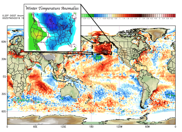
amugs wrote:Great short video on the upcoming winter
thanks mugs...hope it works out this year!!
weatherwatchermom- Senior Enthusiast

- Posts : 3738
Join date : 2014-11-25
Re: Long Range Thread 19.0
![]() by Math23x7 Tue Nov 05, 2019 9:51 pm
by Math23x7 Tue Nov 05, 2019 9:51 pm

Math23x7- Wx Statistician Guru

- Posts : 2379
Join date : 2013-01-08
Re: Long Range Thread 19.0
![]() by amugs Sat Nov 09, 2019 9:35 am
by amugs Sat Nov 09, 2019 9:35 am
_________________
Mugs
AKA:King: Snow Weenie
Self Proclaimed
WINTER 2014-15 : 55.12" +.02 for 6 coatings (avg. 35")
WINTER 2015-16 Total - 29.8" (Avg 35")
WINTER 2016-17 : 39.5" so far

amugs- Advanced Forecaster - Mod

- Posts : 15093
Reputation : 213
Join date : 2013-01-07
Age : 54
Location : Hillsdale,NJ
Re: Long Range Thread 19.0
![]() by amugs Sun Nov 10, 2019 8:21 pm
by amugs Sun Nov 10, 2019 8:21 pm
https://twitter.com/griteater/status/1193504771375861760?s=19
_________________
Mugs
AKA:King: Snow Weenie
Self Proclaimed
WINTER 2014-15 : 55.12" +.02 for 6 coatings (avg. 35")
WINTER 2015-16 Total - 29.8" (Avg 35")
WINTER 2016-17 : 39.5" so far
amugs- Advanced Forecaster - Mod
- Posts : 15093
Reputation : 213
Join date : 2013-01-07
Age : 54
Location : Hillsdale,NJ
Re: Long Range Thread 19.0
![]() by Frank_Wx Mon Nov 11, 2019 12:56 pm
by Frank_Wx Mon Nov 11, 2019 12:56 pm
Next week our weather will moderate a bit to seasonal or slightly milder than normal, but it's possible the pattern is re-loading for another winter blast near Thanksgiving into the last few days of November. An intense trough is poised to develop over the Aleutians this weekend. That will set the stage for possible ridging across the EPO/PNA domains with some models even showing a -NAO developing later this month.
In sum not much to look forward to the next 10 days but the time after that could make things exciting again.
_________________
_______________________________________________________________________________________________________
CLICK HERE to view NJ Strong Snowstorm Classifications

Frank_Wx- Godzilla Seeker

- Posts : 21305
Reputation : 328
Join date : 2013-01-05
Age : 31
Location : Jersey City, NJ -

Re: Long Range Thread 19.0
![]() by amugs Tue Nov 12, 2019 11:11 am
by amugs Tue Nov 12, 2019 11:11 am
Courtesy of Ventrice
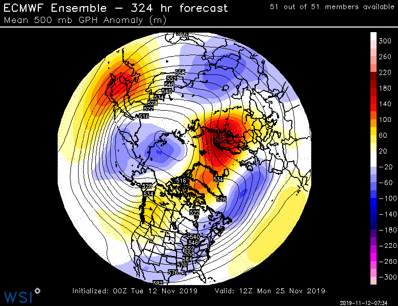
Courtesy of Cohen
_________________
Mugs
AKA:King: Snow Weenie
Self Proclaimed
WINTER 2014-15 : 55.12" +.02 for 6 coatings (avg. 35")
WINTER 2015-16 Total - 29.8" (Avg 35")
WINTER 2016-17 : 39.5" so far
amugs- Advanced Forecaster - Mod
- Posts : 15093
Reputation : 213
Join date : 2013-01-07
Age : 54
Location : Hillsdale,NJ
Re: Long Range Thread 19.0
![]() by CPcantmeasuresnow Wed Nov 13, 2019 7:01 am
by CPcantmeasuresnow Wed Nov 13, 2019 7:01 am
Math23x7 wrote:11/4/19 0Z ECMWF OP hr 99; 11/7/19 10 PM EST, NY State.
Interesting....

Just catching up on the last 6 months.
Mike from Albany? This should make for some interesting observations. I was just in Lenox Mass last weekend, a mere stones throw from your new residence. Are you in the city of Albany or one of the surrounding towns. What is the elevation where you are?

CPcantmeasuresnow- Wx Statistician Guru
- Posts : 7274
Reputation : 230
Join date : 2013-01-07
Age : 103
Location : Eastern Orange County, NY
Re: Long Range Thread 19.0
![]() by amugs Wed Nov 13, 2019 1:17 pm
by amugs Wed Nov 13, 2019 1:17 pm
https://twitter.com/jhomenuk/status/1194677859949957121?s=20
_________________
Mugs
AKA:King: Snow Weenie
Self Proclaimed
WINTER 2014-15 : 55.12" +.02 for 6 coatings (avg. 35")
WINTER 2015-16 Total - 29.8" (Avg 35")
WINTER 2016-17 : 39.5" so far
amugs- Advanced Forecaster - Mod
- Posts : 15093
Reputation : 213
Join date : 2013-01-07
Age : 54
Location : Hillsdale,NJ
Re: Long Range Thread 19.0
![]() by CPcantmeasuresnow Wed Nov 13, 2019 2:56 pm
by CPcantmeasuresnow Wed Nov 13, 2019 2:56 pm
CPcantmeasuresnow- Wx Statistician Guru
- Posts : 7274
Reputation : 230
Join date : 2013-01-07
Age : 103
Location : Eastern Orange County, NY
Re: Long Range Thread 19.0
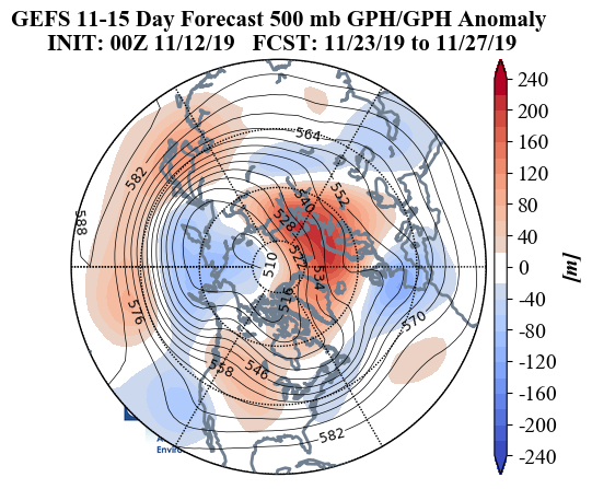
![]() by amugs Thu Nov 14, 2019 10:55 pm
by amugs Thu Nov 14, 2019 10:55 pm
Maps did not show up so here are these Steady Decline
There is a correlation from what Joe D at Wxbell is working on between the SH (Southern Hemisphere)Polar Vortex variations to the NH Polar Vortex variations and displacements. We have see two such perturbations, one we are coming out of, if this were a month or 7 weeks from now with this air mass was be crying it would be so cold, anyway we have so many factors in our favor:
+ Indian Ocean Dipole which is to cause a Postive EAMT - East Asian mountain torque whi h is to attack the PV, ripple the jet and pac jet and help.pump the EPO Negative
Modoki Weak El Nino which should help force the MJO into the favorable phases 8,1,2 and force the upward motion in the dateline region. Tjis will help promote the EPO and the ridge on the west coast thus a positive PNA.
This will also help the STJ sub tropical jet to be active and feed our storms
 Coldw aters off SA continent and warmers as yuo reach teh dateline region at 180*
Volcanic Activity tjis has been very active and we have had 9 VEI 3 volcanic explosions and 2 VEI 4/5 explosions. These have occurred over the last 9 months thus spew vast amounts of aerosols, dust, particles into the stratosphere hence the gorgeous dusk twilight skies of purples and pinks from the arctic to the tropics s. That is a direct result of these eruptions.
The very cold thermosphere, coldest since NASA has been keeping records. It affects remains to be seen 2009 was the last time it was this low.
Thermosphere Climate Index
today: 3.80x10¹⁰ W Cold
Max: 49.4x10¹⁰ W Hot (10/1957)
Min: 2.05x10¹⁰ W Cold (02/2009)
Warm blob in the NE PAC means a vortwx will form and strengthen this winter thus promoting a N EPO which will drive cold air into the Eastern and Central Regions of USA.

Warmish Atlantic overall to help fuel our storms.

Low solar, helps promote a N NAO as the QBO winds re dws ending into the N phase.
Spotless Days
Current Stretch: 2 days
2019 total: 238 days (75%)
2018 total: 221 days (61%)
2017 total: 104 days (28%)
2016 total: 32 days (9%)
2015 total: 0 days (0%)
2014 total: 1 day (<1%)
2013 total: 0 days (0%)
2012 total: 0 days (0%)
2011 total: 2 days (<1%)
2010 total: 51 days (14%)
2009 total: 260 days (71%)
2008 total: 268 days (73%)
2007 total: 152 days (42%)
2006 total: 70 days (19%)
Low sea ice in the Barents Sea region that will help promote a N AO and NAO at times
.
Lastly the tremendous snow extent over the NH is off the charts which will have an albedo effect and will is forming a feedback cycle as we are seeing and the extent of the snow should cover bast majorities of NA by the end of the month with some regions having feet of snow coverage. This will help our cold air source region for air not to modify but actually cool down as it makes its trek to us over this snowpack terrain.

And by the end of the month this will grow and deepen


I really like what we are seeing in form of the variables for this winter
_________________
Mugs
AKA:King: Snow Weenie
Self Proclaimed
WINTER 2014-15 : 55.12" +.02 for 6 coatings (avg. 35")
WINTER 2015-16 Total - 29.8" (Avg 35")
WINTER 2016-17 : 39.5" so far
amugs- Advanced Forecaster - Mod
- Posts : 15093
Reputation : 213
Join date : 2013-01-07
Age : 54
Location : Hillsdale,NJ
Re: Long Range Thread 19.0
![]() by amugs Fri Nov 15, 2019 1:28 pm
by amugs Fri Nov 15, 2019 1:28 pm
Compliments of Superstorm from 33&rain site
Mean look


_________________
Mugs
AKA:King: Snow Weenie
Self Proclaimed
WINTER 2014-15 : 55.12" +.02 for 6 coatings (avg. 35")
WINTER 2015-16 Total - 29.8" (Avg 35")
WINTER 2016-17 : 39.5" so far
amugs- Advanced Forecaster - Mod
- Posts : 15093
Reputation : 213
Join date : 2013-01-07
Age : 54
Location : Hillsdale,NJ
Re: Long Range Thread 19.0
![]() by Math23x7 Fri Nov 15, 2019 11:42 pm
by Math23x7 Fri Nov 15, 2019 11:42 pm
CPcantmeasuresnow wrote:
Just catching up on the last 6 months.
Mike from Albany? This should make for some interesting observations. I was just in Lenox Mass last weekend, a mere stones throw from your new residence. Are you in the city of Albany or one of the surrounding towns. What is the elevation where you are?
Hi CP. Yes, I am in the Albany region now. More specifically though, I am in Colonie and at 300 feet for elevation. Areas a few miles to my west as well as areas about a mile across the Hudson are much higher elevation wise. So there will be instances where it is raining where I live but snowing in those areas.
Now, while Albany does have typically do better snow wise than NYC, I am concerned about the I-95 crushers that'll screw me over. Albany has been keeping weather records since 1884. In the 135 snow seasons, only 9 times has NYC out-snowed Albany. Three of those nine though happened in the past 15 years: 2005-06, 2009-10, and 2015-16. 2005-06 had the February 11-12, 2006 Roidzilla for I-95. 2009-10 had virtually everything suppressed. 2015-16 had the January 23, 2016 snow event which gave 27.5" to NYC but 0" for Albany.
Last Tuesday, I had my first accumulations. It was actually freezing rain for a couple of hours before changing over to a coating of snow by daybreak. Since I drive to work 6 miles away, the struggle was scraping the ice off the car. Since I never really had to drive much in the snow in NYC (I took public transportation to work beforehand), it was something to be picked up on.
Anyway, this being the long range thread, it does look like the next couple of weeks look to be on the cold side overall. It wouldn't shock me if this ends up becoming the coldest November in decades around these parts.
Math23x7- Wx Statistician Guru
- Posts : 2379
Reputation : 68
Join date : 2013-01-08
Re: Long Range Thread 19.0
![]() by Frank_Wx Sat Nov 16, 2019 11:10 am
by Frank_Wx Sat Nov 16, 2019 11:10 am
The result looks like a very anomalous ridge off the west coast. We need to watch if that ridge axis is still too far west. That would risk storms tracking along the coast rather than off the coast. However, the -NAO blocking Mugs posted could help suppress some of that. The models are going back and forth on the strength of the -NAO but it does seem likely we'll see a ridge pressing down from Greenland.
_________________
_______________________________________________________________________________________________________
CLICK HERE to view NJ Strong Snowstorm Classifications
Frank_Wx- Godzilla Seeker
- Posts : 21305
Reputation : 328
Join date : 2013-01-05
Age : 31
Location : Jersey City, NJ -
Re: Long Range Thread 19.0
![]() by hyde345 Sat Nov 16, 2019 11:55 am
by hyde345 Sat Nov 16, 2019 11:55 am
Math23x7 wrote:CPcantmeasuresnow wrote:
Just catching up on the last 6 months.
Mike from Albany? This should make for some interesting observations. I was just in Lenox Mass last weekend, a mere stones throw from your new residence. Are you in the city of Albany or one of the surrounding towns. What is the elevation where you are?
Hi CP. Yes, I am in the Albany region now. More specifically though, I am in Colonie and at 300 feet for elevation. Areas a few miles to my west as well as areas about a mile across the Hudson are much higher elevation wise. So there will be instances where it is raining where I live but snowing in those areas.
Now, while Albany does have typically do better snow wise than NYC, I am concerned about the I-95 crushers that'll screw me over. Albany has been keeping weather records since 1884. In the 135 snow seasons, only 9 times has NYC out-snowed Albany. Three of those nine though happened in the past 15 years: 2005-06, 2009-10, and 2015-16. 2005-06 had the February 11-12, 2006 Roidzilla for I-95. 2009-10 had virtually everything suppressed. 2015-16 had the January 23, 2016 snow event which gave 27.5" to NYC but 0" for Albany.
Last Tuesday, I had my first accumulations. It was actually freezing rain for a couple of hours before changing over to a coating of snow by daybreak. Since I drive to work 6 miles away, the struggle was scraping the ice off the car. Since I never really had to drive much in the snow in NYC (I took public transportation to work beforehand), it was something to be picked up on.
Anyway, this being the long range thread, it does look like the next couple of weeks look to be on the cold side overall. It wouldn't shock me if this ends up becoming the coldest November in decades around these parts.
You will get your share of snow this season trust me. Hopefully you will be hearing the term "mohawk convergence" plenty this year. The difference in weather between the city and where you are is night and day, especially in winter.

hyde345- Pro Enthusiast

- Posts : 1082
Reputation : 48
Join date : 2013-01-08
Location : Hyde Park, NY
Re: Long Range Thread 19.0
![]() by sroc4 Sat Nov 16, 2019 1:33 pm
by sroc4 Sat Nov 16, 2019 1:33 pm
Frank_Wx wrote:Thanks for posting updates Mugs. Beginning next week through the end of the month there looks to be multiple chances for our first accumulating snow. The MJO wave I've talked about in my last few posts is now crossing the Dateline, leading me to believe some of the warmer than normal SSTA's along the equatorial Pacific is causing enough instability to keep these waves long-lived. This in part is due to the Nino-like conditions.
The result looks like a very anomalous ridge off the west coast. We need to watch if that ridge axis is still too far west. That would risk storms tracking along the coast rather than off the coast. However, the -NAO blocking Mugs posted could help suppress some of that. The models are going back and forth on the strength of the -NAO but it does seem likely we'll see a ridge pressing down from Greenland.
Im just not as excited as many seem to be at the prospect of a sustained west based -NAO, at least not over the next few weeks. It may set up more consistently later but I just cant get excited about it now. Perhaps its because the elusive sustained winter season west based -NAO (aka the unicorn) just hasn't existed very much despite tales of its prospective arrival over the past few years.
That said I like the prospects of the split flow setting up for the end of the week. ULL in the SW ejecting energy in the southern branch, with northern branch energy digging into the GL and NE. Of course timing is everything but there is a shot at some accumulating snow out of it. Model chaos will def be the theme early on in the week until they can get a handle on the details of the timing strength, etc of he energy ejecting out of the SW and diving in from Canada. Still some pretty significant differences along the EC as well as out west 4days out. This is euro and GFS valid Wed 18z this week.


_________________
"In weather and in life, there's no winning and losing; there's only winning and learning."
WINTER 2012/2013 TOTALS 43.65"WINTER 2017/2018 TOTALS 62.85" WINTER 2022/2023 TOTALS 4.9"
WINTER 2013/2014 TOTALS 64.85"WINTER 2018/2019 TOTALS 14.25" WINTER 2023/2024 TOTALS 13.1"
WINTER 2014/2015 TOTALS 71.20"WINTER 2019/2020 TOTALS 6.35"
WINTER 2015/2016 TOTALS 35.00"WINTER 2020/2021 TOTALS 37.75"
WINTER 2016/2017 TOTALS 42.25"WINTER 2021/2022 TOTALS 31.65"

sroc4- Admin
- Posts : 8331
Reputation : 301
Join date : 2013-01-07
Location : Wading River, LI
Re: Long Range Thread 19.0
![]() by sroc4 Sat Nov 16, 2019 1:38 pm
by sroc4 Sat Nov 16, 2019 1:38 pm


_________________
"In weather and in life, there's no winning and losing; there's only winning and learning."
WINTER 2012/2013 TOTALS 43.65"WINTER 2017/2018 TOTALS 62.85" WINTER 2022/2023 TOTALS 4.9"
WINTER 2013/2014 TOTALS 64.85"WINTER 2018/2019 TOTALS 14.25" WINTER 2023/2024 TOTALS 13.1"
WINTER 2014/2015 TOTALS 71.20"WINTER 2019/2020 TOTALS 6.35"
WINTER 2015/2016 TOTALS 35.00"WINTER 2020/2021 TOTALS 37.75"
WINTER 2016/2017 TOTALS 42.25"WINTER 2021/2022 TOTALS 31.65"
sroc4- Admin
- Posts : 8331
Reputation : 301
Join date : 2013-01-07
Location : Wading River, LI
Re: Long Range Thread 19.0
![]() by skinsfan1177 Sat Nov 16, 2019 3:02 pm
by skinsfan1177 Sat Nov 16, 2019 3:02 pm

skinsfan1177- Senior Enthusiast
- Posts : 4485
Reputation : 35
Join date : 2013-01-07
Age : 46
Location : Point Pleasant Boro
Re: Long Range Thread 19.0
![]() by sroc4 Wed Nov 20, 2019 7:38 am
by sroc4 Wed Nov 20, 2019 7:38 am
I will try and put together a more detailed discussion about my thoughts on the up coming pattern using maps etc from the 500mb level to the strat at a later date. Again things may change but my intital thoughts are just ehh for whats to come over the next month or so.
_________________
"In weather and in life, there's no winning and losing; there's only winning and learning."
WINTER 2012/2013 TOTALS 43.65"WINTER 2017/2018 TOTALS 62.85" WINTER 2022/2023 TOTALS 4.9"
WINTER 2013/2014 TOTALS 64.85"WINTER 2018/2019 TOTALS 14.25" WINTER 2023/2024 TOTALS 13.1"
WINTER 2014/2015 TOTALS 71.20"WINTER 2019/2020 TOTALS 6.35"
WINTER 2015/2016 TOTALS 35.00"WINTER 2020/2021 TOTALS 37.75"
WINTER 2016/2017 TOTALS 42.25"WINTER 2021/2022 TOTALS 31.65"
sroc4- Admin
- Posts : 8331
Reputation : 301
Join date : 2013-01-07
Location : Wading River, LI
Re: Long Range Thread 19.0
![]() by HectorO Wed Nov 20, 2019 10:32 am
by HectorO Wed Nov 20, 2019 10:32 am

HectorO- Pro Enthusiast
- Posts : 959
Reputation : 27
Join date : 2013-01-11
Re: Long Range Thread 19.0
![]() by heehaw453 Wed Nov 20, 2019 11:18 am
by heehaw453 Wed Nov 20, 2019 11:18 am
We just have to see how things unfold, but recent Decembers have been governed by Pacific side of things and it's been bad for snow lovers (zonal fire hose). I have very modest expectations, and we shall see if the pattern can be more favorable this year as I'd love a good snowy December this year.
heehaw453- Advanced Forecaster

- Posts : 3906
Reputation : 86
Join date : 2014-01-20
Location : Bedminster Township, PA Elevation 600' ASL
Re: Long Range Thread 19.0
![]() by amugs Wed Nov 20, 2019 8:45 pm
by amugs Wed Nov 20, 2019 8:45 pm
You have a N NAO setting up as I write that may have an influence to this weekends and next weeks storm. A sigma 2 -2.5 block is forming which means a somewhat moderate block.
Will it be cold bouts yes, but it will hold the SE ridge at bay, suppress it.
MJO going into phases

Here's the look from the GEFS


Time will tell but lots of latent heat flowing up to Greenland.
Also, we have been bombarded sin e last spring with cosmic Ray's which produced a large geomagnetic affects and cloud nucleization (formation). This along with low solar has a huge propensity to form blocking in the arctic regions aka NAO, AO and EPO.
_________________
Mugs
AKA:King: Snow Weenie
Self Proclaimed
WINTER 2014-15 : 55.12" +.02 for 6 coatings (avg. 35")
WINTER 2015-16 Total - 29.8" (Avg 35")
WINTER 2016-17 : 39.5" so far
amugs- Advanced Forecaster - Mod
- Posts : 15093
Reputation : 213
Join date : 2013-01-07
Age : 54
Location : Hillsdale,NJ
Re: Long Range Thread 19.0
![]() by sroc4 Thu Nov 21, 2019 4:31 pm
by sroc4 Thu Nov 21, 2019 4:31 pm
_________________
"In weather and in life, there's no winning and losing; there's only winning and learning."
WINTER 2012/2013 TOTALS 43.65"WINTER 2017/2018 TOTALS 62.85" WINTER 2022/2023 TOTALS 4.9"
WINTER 2013/2014 TOTALS 64.85"WINTER 2018/2019 TOTALS 14.25" WINTER 2023/2024 TOTALS 13.1"
WINTER 2014/2015 TOTALS 71.20"WINTER 2019/2020 TOTALS 6.35"
WINTER 2015/2016 TOTALS 35.00"WINTER 2020/2021 TOTALS 37.75"
WINTER 2016/2017 TOTALS 42.25"WINTER 2021/2022 TOTALS 31.65"
sroc4- Admin
- Posts : 8331
Reputation : 301
Join date : 2013-01-07
Location : Wading River, LI
Re: Long Range Thread 19.0
![]() by sroc4 Fri Nov 22, 2019 7:18 am
by sroc4 Fri Nov 22, 2019 7:18 am
_________________
"In weather and in life, there's no winning and losing; there's only winning and learning."
WINTER 2012/2013 TOTALS 43.65"WINTER 2017/2018 TOTALS 62.85" WINTER 2022/2023 TOTALS 4.9"
WINTER 2013/2014 TOTALS 64.85"WINTER 2018/2019 TOTALS 14.25" WINTER 2023/2024 TOTALS 13.1"
WINTER 2014/2015 TOTALS 71.20"WINTER 2019/2020 TOTALS 6.35"
WINTER 2015/2016 TOTALS 35.00"WINTER 2020/2021 TOTALS 37.75"
WINTER 2016/2017 TOTALS 42.25"WINTER 2021/2022 TOTALS 31.65"
sroc4- Admin
- Posts : 8331
Reputation : 301
Join date : 2013-01-07
Location : Wading River, LI
Re: Long Range Thread 19.0
![]() by algae888 Fri Nov 22, 2019 7:28 am
by algae888 Fri Nov 22, 2019 7:28 am

algae888- Advanced Forecaster
- Posts : 5311
Reputation : 46
Join date : 2013-02-05
Age : 61
Location : mt. vernon, new york
Re: Long Range Thread 19.0
![]() by algae888 Fri Nov 22, 2019 7:29 am
by algae888 Fri Nov 22, 2019 7:29 am
No problem scott basically will have a negative Nao for the next 10 days or so and then a negative EPO after that if long-range guidance is correct should be a tight gradient somewhere in the east going west to east Northside cold Southside hot active pattern those are my thoughtssroc4 wrote:CRAP!!! Al just inadvertently deleted your post. Sorry man. I was trying to quote you and respond, but I apparently clicked on edit. The I was going to delete my post and write it differently and apparently I was deleting your post.
algae888- Advanced Forecaster
- Posts : 5311
Reputation : 46
Join date : 2013-02-05
Age : 61
Location : mt. vernon, new york
Re: Long Range Thread 19.0
![]() by sroc4 Fri Nov 22, 2019 7:54 am
by sroc4 Fri Nov 22, 2019 7:54 am
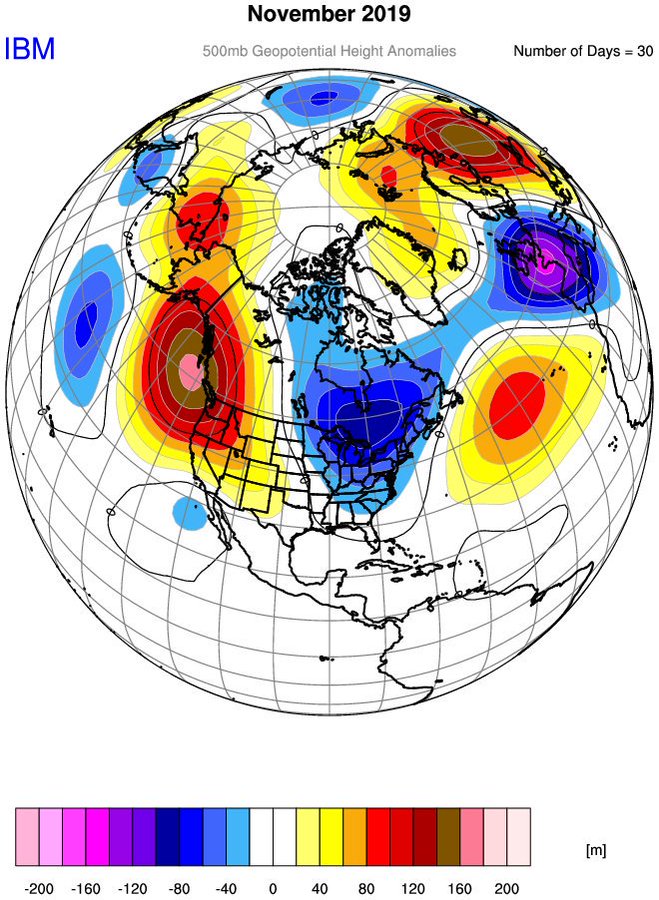
The strat is forecast to shift to the other side of the N hemisphere for a bit. Whenever that happens it typically offers resistance in the troposphere for the 500mb to hit and hold with the polar/arctic air dep into the Eastern CONUS.

Here are the image for the strat vortex mean positioning for the month of Nov through the 18th, the resultant 500mb mean trough ridge orientation, and the mean 2m temps as a result. You can clearly see the correlation.


The other part is the MJO wave. It originally had it crashing into the COD after this phase 8 propagation and recirculate back into favorable phases; however, if you have been watching the trends this MJO wave continues into less favorable phases and slows.
Looking at the means in the EPS and GEFS ensembles respectively you can see there is a fundamental difference in the depiction of where the mean trough ridge axis will be in the longer range again specifically what is related to the Pac side of things. Notice the axis of the mean ridge trough axis between the two.


Unfortunatly for now I just dont agree with the GEFS depiction of what we are seeing headed into Dec. because it doesn't agree with the the forcing mechanisms coming out of the Pac and what the strat is attempting to do ATT. Like you said in the post I accidently deleted IF this aspect of the modeling is correct. Time will tell and I hope Im wrong but its how I see it now. This -NAO that is happening may end up all for not, or perhaps be just enough to offer up a few "chances" that may even come to fruition, but again the overall big picture to me doesnt look ready.
Last edited by sroc4 on Wed Dec 04, 2019 6:26 am; edited 1 time in total
_________________
"In weather and in life, there's no winning and losing; there's only winning and learning."
WINTER 2012/2013 TOTALS 43.65"WINTER 2017/2018 TOTALS 62.85" WINTER 2022/2023 TOTALS 4.9"
WINTER 2013/2014 TOTALS 64.85"WINTER 2018/2019 TOTALS 14.25" WINTER 2023/2024 TOTALS 13.1"
WINTER 2014/2015 TOTALS 71.20"WINTER 2019/2020 TOTALS 6.35"
WINTER 2015/2016 TOTALS 35.00"WINTER 2020/2021 TOTALS 37.75"
WINTER 2016/2017 TOTALS 42.25"WINTER 2021/2022 TOTALS 31.65"
sroc4- Admin
- Posts : 8331
Reputation : 301
Join date : 2013-01-07
Location : Wading River, LI
Re: Long Range Thread 19.0
![]() by Frank_Wx Sat Nov 23, 2019 8:00 pm
by Frank_Wx Sat Nov 23, 2019 8:00 pm

As doc alluded the ridge is displaced too far west so the pattern for us would feature something like cold, cutter, cold. A cutter, as you know, is a storm that 'cuts' or tracks well inland flooding us with mild temps.
Now...our hope is the -NAO. If this feature stays relevant one week from now then there is a chance it prevents a cutter and actually forms some type of coastal / miller-B system. December 2nd-3rd is the time frame to watch. And if that does not work out we have another shot near the 6th-8th.

_________________
_______________________________________________________________________________________________________
CLICK HERE to view NJ Strong Snowstorm Classifications
Frank_Wx- Godzilla Seeker
- Posts : 21305
Reputation : 328
Join date : 2013-01-05
Age : 31
Location : Jersey City, NJ -
Page 3 of 28 • 1, 2, 3, 4 ... 15 ... 28 ![]()
|
|
|