Long Range Thread 19.0
+38
essexcountypete
SoulSingMG
Scullybutcher
phil155
bobjohnsonforthehall
Zhukov1945
dsix85
Radz
lja
Grselig
devsman
DAYBLAZER
Irish
Dunnzoo
jimv45
sabamfa
SENJsnowman
frank 638
heehaw453
skinsfan1177
sroc4
hyde345
CPcantmeasuresnow
Math23x7
nutleyblizzard
rb924119
weatherwatchermom
aiannone
jmanley32
billg315
dkodgis
Snow88
algae888
docstox12
HectorO
mwilli
amugs
Frank_Wx
42 posters
Page 23 of 28
Page 23 of 28 •  1 ... 13 ... 22, 23, 24 ... 28
 Re: Long Range Thread 19.0
CPcantmeasuresnow wrote:amugs wrote:The Phase 3 forecast for the MJO maybe able to bring us a trough and pump the PNA but the positioning of both along with the trough axis are critical to the next storms chance next weekendish.
This has been a ratter for sure.
One thing I have seen and learned, the EPO, Tropical Convection run our winters.
Alaska isn't a fridge it beats back the SE Ridge.
Not busting chops here Mugs just curious. You talked about the solar minimum a lot during the fall having a positive impact on us for this winter. Why do you think that didn't have the effect you were thinking it would? I know almost every teleconnection has worked against us the past 6 weeks and the MJO just hasn't progressed into the cold phases as many predicted it would by mid month. Were there just to many other negatives to overcome or do you think the solar minimum does not have the effect overall on our weather that many thought?
Keep hope alive my optimistic friend.
My thoughts on this CP are that low solar isn’t a 1:1 effect. It’s more of a longer term effect. When/if low solar persists there would be a lag to its larger scale effects. We have only scratched the surface to how the sun effects our planet. In a nut shell the suns effects work on a time scale that most have a hard time understanding. For you and me it might be a life time. For earth it’s overnight. If that makes sense. That’s my take anyway.
sroc4- Admin

- Posts : 8331
Join date : 2013-01-07
 Re: Long Range Thread 19.0
Regarding next week. There will most likely be several waves of low pressure that don't track favorably for us. This means baroclinic zone is not favorable for us. There will be high pressure (not super strong) in a good spot for a period of time to give some marginal cold air.
To get a nice overrunning event you need deeper cold in all layers of the atmospheric column and juicy slug of moisture that it way out in front of your cutting low pressure. Otherwise you get a mixed bad that won't add up to much.
Path to snow is one of these storms is able to track off the coast and setup the baroclinic zone to our south and then another follows it with the cold air in place. That would do it for us.
I'm not saying NW and interior folks can't get some accumulation, but it'll be quite modest without some movement of that zone and moisture following it. Not an easy task folks as we have nothing to deflect the lows underneath us. You all here the same broken record this year from us posters and it's a real shame.
heehaw453- Advanced Forecaster

- Posts : 3906
Join date : 2014-01-20
 Re: Long Range Thread 19.0
sroc4 wrote:CPcantmeasuresnow wrote:amugs wrote:The Phase 3 forecast for the MJO maybe able to bring us a trough and pump the PNA but the positioning of both along with the trough axis are critical to the next storms chance next weekendish.
This has been a ratter for sure.
One thing I have seen and learned, the EPO, Tropical Convection run our winters.
Alaska isn't a fridge it beats back the SE Ridge.
Not busting chops here Mugs just curious. You talked about the solar minimum a lot during the fall having a positive impact on us for this winter. Why do you think that didn't have the effect you were thinking it would? I know almost every teleconnection has worked against us the past 6 weeks and the MJO just hasn't progressed into the cold phases as many predicted it would by mid month. Were there just to many other negatives to overcome or do you think the solar minimum does not have the effect overall on our weather that many thought?
Keep hope alive my optimistic friend.
My thoughts on this CP are that low solar isn’t a 1:1 effect. It’s more of a longer term effect. When/if low solar persists there would be a lag to its larger scale effects. We have only scratched the surface to how the sun effects our planet. In a nut shell the suns effects work on a time scale that most have a hard time understanding. For you and me it might be a life time. For earth it’s overnight. If that makes sense. That’s my take anyway.
I've heard many mets speak of a high correlation between solar minimums and high latitude blocking. That correlation obviously has other variables in the mix as we had not too much of that blocking this winter. It's certainly not a a causality of blocking though as seen this year. Interesting stuff...
heehaw453- Advanced Forecaster

- Posts : 3906
Reputation : 86
Join date : 2014-01-20
Location : Bedminster Township, PA Elevation 600' ASL
 Re: Long Range Thread 19.0
heehaw453 wrote:Regarding next week. There will most likely be several waves of low pressure that don't track favorably for us. This means baroclinic zone is not favorable for us. There will be high pressure (not super strong) in a good spot for a period of time to give some marginal cold air.
To get a nice overrunning event you need deeper cold in all layers of the atmospheric column and juicy slug of moisture that it way out in front of your cutting low pressure. Otherwise you get a mixed bad that won't add up to much.
Path to snow is one of these storms is able to track off the coast and setup the baroclinic zone to our south and then another follows it with the cold air in place. That would do it for us.
I'm not saying NW and interior folks can't get some accumulation, but it'll be quite modest without some movement of that zone and moisture following it. Not an easy task folks as we have nothing to deflect the lows underneath us. You all here the same broken record this year from us posters and it's a real shame.
It looks like there will be three waves riding the front with the last wave being the strongest as of modeling so far. I think we want a stronger first wave to push the front as far south as possible and try and get on the cold side for the second wave as the third wave looks to be too amped and it's going to rain for the coastal plain this is exactly the GFS Evolution today. I believe climo is on our side as far as getting the front to push further south than what models have now but we shall see

algae888- Advanced Forecaster

- Posts : 5311
Reputation : 46
Join date : 2013-02-05
Age : 61
Location : mt. vernon, new york
 Re: Long Range Thread 19.0
In regards to the long-term February looks to be much different than January as January was very dry February looks very active with cold air not too far to our North I think we're going to favorably Time one or two systems through at least the first half of the month but we shall see

algae888- Advanced Forecaster

- Posts : 5311
Reputation : 46
Join date : 2013-02-05
Age : 61
Location : mt. vernon, new york
 Re: Long Range Thread 19.0
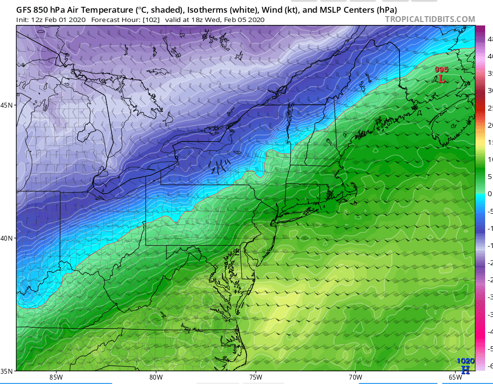
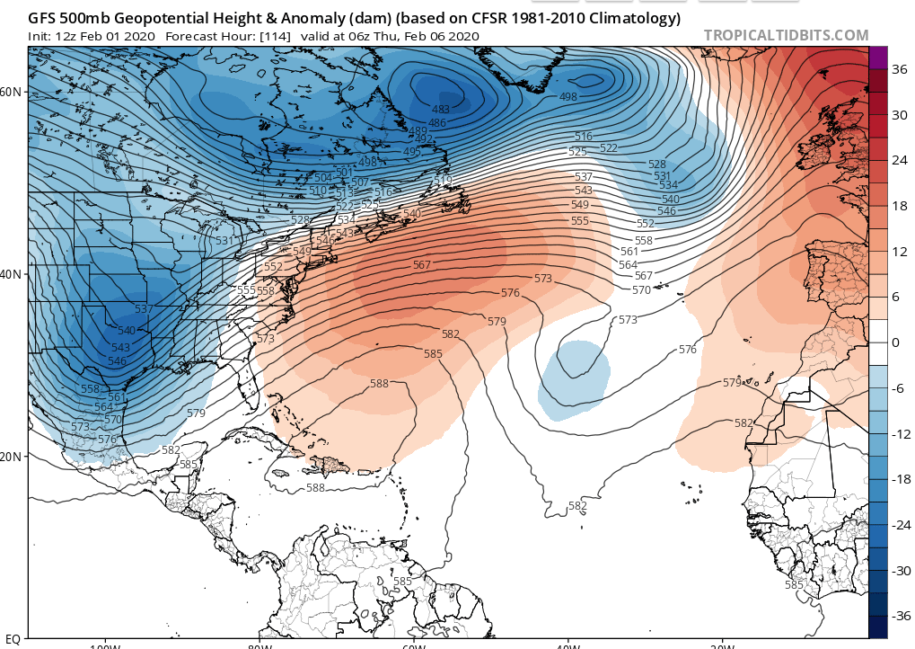
Great depiction of what to watch for with this. How far does the baroclinic drop after this storm pulls away? And where does the last wave track? This Atlantic ridge tells me any wave will be really close to us which is warmer solution than we'd like. If however the zone drops below your area, then the follow up waves will ride that path and you'll do well. Like 6"+ well. At least something of interest for now...


heehaw453- Advanced Forecaster

- Posts : 3906
Reputation : 86
Join date : 2014-01-20
Location : Bedminster Township, PA Elevation 600' ASL
 Re: Long Range Thread 19.0
algae888 wrote:heehaw453 wrote:Regarding next week. There will most likely be several waves of low pressure that don't track favorably for us. This means baroclinic zone is not favorable for us. There will be high pressure (not super strong) in a good spot for a period of time to give some marginal cold air.
To get a nice overrunning event you need deeper cold in all layers of the atmospheric column and juicy slug of moisture that it way out in front of your cutting low pressure. Otherwise you get a mixed bad that won't add up to much.
Path to snow is one of these storms is able to track off the coast and setup the baroclinic zone to our south and then another follows it with the cold air in place. That would do it for us.
I'm not saying NW and interior folks can't get some accumulation, but it'll be quite modest without some movement of that zone and moisture following it. Not an easy task folks as we have nothing to deflect the lows underneath us. You all here the same broken record this year from us posters and it's a real shame.
It looks like there will be three waves riding the front with the last wave being the strongest as of modeling so far. I think we want a stronger first wave to push the front as far south as possible and try and get on the cold side for the second wave as the third wave looks to be too amped and it's going to rain for the coastal plain this is exactly the GFS Evolution today. I believe climo is on our side as far as getting the front to push further south than what models have now but we shall see
Agree completely Algae. It all depends on how far that baroclinic zone can be pushed south and east.
heehaw453- Advanced Forecaster

- Posts : 3906
Reputation : 86
Join date : 2014-01-20
Location : Bedminster Township, PA Elevation 600' ASL
 Re: Long Range Thread 19.0
Uk like the GFS brings the front and through Wednesday morning then has snow for the area with the second wave similar to the GFS and then the third wave to warm and rains for most of the area

algae888- Advanced Forecaster

- Posts : 5311
Reputation : 46
Join date : 2013-02-05
Age : 61
Location : mt. vernon, new york
 Re: Long Range Thread 19.0
18Z GFS is getting closer to getting this interesting at hour 108. It's not quite there, but baroclinic zone pulled in much more favorable spot and high pressure over Plattsburgh NY keeping the mid-level winds more northerly. If that last wave can ride a little more eastward than northward following the baroclinic zone, then it'd be a really nice event.
Give this 2 more days to get straightened out. This can trend either way at this point, so don't expect much until there's consistency which currently is not there.
Give this 2 more days to get straightened out. This can trend either way at this point, so don't expect much until there's consistency which currently is not there.
heehaw453- Advanced Forecaster

- Posts : 3906
Reputation : 86
Join date : 2014-01-20
Location : Bedminster Township, PA Elevation 600' ASL
 Re: Long Range Thread 19.0
Punxsutawney Phil did NOT see his shadow-early spring so sad...not scientific..but just another bad sign of this winter

weatherwatchermom- Senior Enthusiast

- Posts : 3742
Reputation : 77
Join date : 2014-11-25
Age : 60
Location : Hazlet Township, NJ
 Re: Long Range Thread 19.0
weatherwatchermom wrote:Punxsutawney Phil did NOT see his shadow-early spring so sad...not scientific..but just another bad sign of this winter
Yeah, with the forecast it would have been silly for him to say anything else... and already the models have responded with a wetter, warmer event next weekend lol... pattern is relentless
Radz- Pro Enthusiast

- Posts : 1028
Reputation : 17
Join date : 2013-01-12
Location : Cortlandt Manor NY
 Re: Long Range Thread 19.0
Guidance has really muted this threat mid week threat. Shocker right?
Baroclinic zone doesn't look to be anywhere near where it needs to be for the cold air and the right storm track.
This picture tells you a lot. Note the wind directions with a fast retreating high pressure to the north. Strong south westerly flow. Tells me immediate mixing even well NW.
Still 4 days out, but probably toast...

heehaw453- Advanced Forecaster

- Posts : 3906
Reputation : 86
Join date : 2014-01-20
Location : Bedminster Township, PA Elevation 600' ASL
heehaw453- Advanced Forecaster

- Posts : 3906
Reputation : 86
Join date : 2014-01-20
Location : Bedminster Township, PA Elevation 600' ASL
 Re: Long Range Thread 19.0
heehaw453 wrote:Guidance has really muted this threat mid week threat. Shocker right?
Baroclinic zone doesn't look to be anywhere near where it needs to be for the cold air and the right storm track.
This picture tells you a lot. Note the wind directions with a fast retreating high pressure to the north. Strong south westerly flow. Tells me immediate mixing even well NW.
Still 4 days out, but probably toast...
I don't think this is toast N and W. The higher your latitude the better off you are with respect to frozen precip. The window of opportunity will be from the second wave from late Wednesday night-Thursday afternoon the way it looks now. I wouldn't be surprised with a 1-3 inch type mixed bag N and W, again the further north the more snow. Thermals are dicey so still a long way to go for this. GFS is warmer than CMC on 12z runs.

hyde345- Pro Enthusiast

- Posts : 1082
Reputation : 48
Join date : 2013-01-08
Location : Hyde Park, NY
 Re: Long Range Thread 19.0
heehaw453 wrote:Guidance has really muted this threat mid week threat. Shocker right?
Baroclinic zone doesn't look to be anywhere near where it needs to be for the cold air and the right storm track.
This picture tells you a lot. Note the wind directions with a fast retreating high pressure to the north. Strong south westerly flow. Tells me immediate mixing even well NW.
Still 4 days out, but probably toast...
I see you use the GFS today but it is by far the warmest model. The UK consistently gives us several inches of snow Thursday morning and the CMC has trended colder the last two runs even the nam at hour 84 is much colder than the GFS most of the guidance gets the 850 0 C line down to South Jersey and Below Philly we just need precipitation to come in when it's cold enough

algae888- Advanced Forecaster

- Posts : 5311
Reputation : 46
Join date : 2013-02-05
Age : 61
Location : mt. vernon, new york
 Re: Long Range Thread 19.0
Euro has some frozen move in Thursday morning then warms and flips to liquid...

Radz- Pro Enthusiast

- Posts : 1028
Reputation : 17
Join date : 2013-01-12
Location : Cortlandt Manor NY
 Re: Long Range Thread 19.0
WORST. WINTER. EVER. 


nutleyblizzard- Senior Enthusiast

- Posts : 1952
Reputation : 41
Join date : 2014-01-30
Age : 58
Location : Nutley, new jersey
 Re: Long Range Thread 19.0
nutleyblizzard wrote:WORST. WINTER. EVER.
Haha, I feel your pain. This one has been bad but the worst for me was winter 2015-16. 6 f'ing inches the entire season in mid HV, thats hard to do. I remember the January blizzard NYC got 27 inches and I saw 3 flakes. That one hurt because the cutoff was so drastic. 30 miles south of me had a foot and I was sucking virga.

hyde345- Pro Enthusiast

- Posts : 1082
Reputation : 48
Join date : 2013-01-08
Location : Hyde Park, NY
 Re: Long Range Thread 19.0
hyde345 wrote:nutleyblizzard wrote:WORST. WINTER. EVER.
Haha, I feel your pain. This one has been bad but the worst for me was winter 2015-16. 6 f'ing inches the entire season in mid HV, thats hard to do. I remember the January blizzard NYC got 27 inches and I saw 3 flakes. That one hurt because the cutoff was so drastic. 30 miles south of me had a foot and I was sucking virga.
Oh wow. That must have sucked to be very close. Just curious, what year was that blizzard?
toople- Posts : 67
Reputation : 0
Join date : 2015-01-01
Location : Nutley, NJ
 Re: Long Range Thread 19.0
hyde345 wrote:heehaw453 wrote:Guidance has really muted this threat mid week threat. Shocker right?
Baroclinic zone doesn't look to be anywhere near where it needs to be for the cold air and the right storm track.
This picture tells you a lot. Note the wind directions with a fast retreating high pressure to the north. Strong south westerly flow. Tells me immediate mixing even well NW.
Still 4 days out, but probably toast...
I don't think this is toast N and W. The higher your latitude the better off you are with respect to frozen precip. The window of opportunity will be from the second wave from late Wednesday night-Thursday afternoon the way it looks now. I wouldn't be surprised with a 1-3 inch type mixed bag N and W, again the further north the more snow. Thermals are dicey so still a long way to go for this. GFS is warmer than CMC on 12z runs.
Yesterday, I was much more optimistic especially NW for decent accumulations >3". What I see now on the models is a baroclinic zone that is not favorable. It's too north and the depth of the cold air is shallow. The antecedent high pressure is also quick to scoot off the coast. This allows a strong south westerly flow that will torch the mid levels quickly with no depth to the cold air. That being said, I don't think NW will get zero accumulation as the moisture comes in it should be cold enough to support some snow. I could see an 1-2" for LHV/NEPA/NW NJ for sure. but any more north on the zone or any faster exit of the high and it'll be closer to C than 2". Conversely, the reverse is true if the high is more stubborn or the zone is pushed further south. Too early to know ATTM for sure. Just not optimistic as I was yesterday.
Last edited by heehaw453 on Sun Feb 02, 2020 4:33 pm; edited 1 time in total
heehaw453- Advanced Forecaster

- Posts : 3906
Reputation : 86
Join date : 2014-01-20
Location : Bedminster Township, PA Elevation 600' ASL
 Re: Long Range Thread 19.0
toople wrote:hyde345 wrote:nutleyblizzard wrote:WORST. WINTER. EVER.
Haha, I feel your pain. This one has been bad but the worst for me was winter 2015-16. 6 f'ing inches the entire season in mid HV, thats hard to do. I remember the January blizzard NYC got 27 inches and I saw 3 flakes. That one hurt because the cutoff was so drastic. 30 miles south of me had a foot and I was sucking virga.
Oh wow. That must have sucked to be very close. Just curious, what year was that blizzard?
January 22-23 2016.

hyde345- Pro Enthusiast

- Posts : 1082
Reputation : 48
Join date : 2013-01-08
Location : Hyde Park, NY
 Re: Long Range Thread 19.0
algae888 wrote:heehaw453 wrote:Guidance has really muted this threat mid week threat. Shocker right?
Baroclinic zone doesn't look to be anywhere near where it needs to be for the cold air and the right storm track.
This picture tells you a lot. Note the wind directions with a fast retreating high pressure to the north. Strong south westerly flow. Tells me immediate mixing even well NW.
Still 4 days out, but probably toast...
I see you use the GFS today but it is by far the warmest model. The UK consistently gives us several inches of snow Thursday morning and the CMC has trended colder the last two runs even the nam at hour 84 is much colder than the GFS most of the guidance gets the 850 0 C line down to South Jersey and Below Philly we just need precipitation to come in when it's cold enough
I'm rooting for the UKIE! It's by far the most aggressive with the baroclinic zone's southerly position. Just don't really believe it right now
heehaw453- Advanced Forecaster

- Posts : 3906
Reputation : 86
Join date : 2014-01-20
Location : Bedminster Township, PA Elevation 600' ASL
 Re: Long Range Thread 19.0
GFS is trying to spin up a low pressure that gives us backend snowfall on Friday afternoon as it pulls into Canadian Maritimes. I don't buy it right now. Timing on something like that has to be perfect.
Below is what has a shot to deliver for us. Next Saturday night watch this energy. Been showing up on the Euro for several runs. This is northern stream/southern stream phase that cuts underneath us. Too far out to get excited but to me this is much better shot at something meaningful than this other stuff. This scenario is how things get done around here and note that negative tilt starting. Other models have it to in varying degrees. Not expecting anything until we get some consistency and agreement with other models. BIG IF.

Below is what has a shot to deliver for us. Next Saturday night watch this energy. Been showing up on the Euro for several runs. This is northern stream/southern stream phase that cuts underneath us. Too far out to get excited but to me this is much better shot at something meaningful than this other stuff. This scenario is how things get done around here and note that negative tilt starting. Other models have it to in varying degrees. Not expecting anything until we get some consistency and agreement with other models. BIG IF.

heehaw453- Advanced Forecaster

- Posts : 3906
Reputation : 86
Join date : 2014-01-20
Location : Bedminster Township, PA Elevation 600' ASL
 Re: Long Range Thread 19.0
heehaw453 wrote:GFS is trying to spin up a low pressure that gives us backend snowfall on Friday afternoon as it pulls into Canadian Maritimes. I don't buy it right now. Timing on something like that has to be perfect.
Below is what has a shot to deliver for us. Next Saturday night watch this energy. Been showing up on the Euro for several runs. This is northern stream/southern stream phase that cuts underneath us. Too far out to get excited but to me this is much better shot at something meaningful than this other stuff. This scenario is how things get done around here and note that negative tilt starting. Other models have it to in varying degrees. Not expecting anything until we get some consistency and agreement with other models. BIG IF.
Yes next weekend looks much better than the midweek system as the midweek system trended warmer last night as the models kind of amped up the low pressure we need a shared out system if we going to see any snow midweek I still feel the high will press further South and we'll have some snow Thursday morning which will eventually be washed away by rain. Then the GFS has another system right around Valentine's Day at least we have something to track and it's much better than January

algae888- Advanced Forecaster

- Posts : 5311
Reputation : 46
Join date : 2013-02-05
Age : 61
Location : mt. vernon, new york
 Re: Long Range Thread 19.0
I also like this 500mb height on Euro Ensembles. There is room between the Atlantic ridge and the Midwest trough. Storm most likely wont go OTS, but has enough room on west side not to cut. Also, note the -EPO (Alaska ridge) supplying some decent cold air and this wouldn't be the usual marginal air mass.
This maybe best potential since early December. Have to see consistency and model agreement in the next 2/3 days.

This maybe best potential since early December. Have to see consistency and model agreement in the next 2/3 days.

heehaw453- Advanced Forecaster

- Posts : 3906
Reputation : 86
Join date : 2014-01-20
Location : Bedminster Township, PA Elevation 600' ASL
 Re: Long Range Thread 19.0
NWS has me for 1-2 inches snow late Wed into Thurs and an icy mix. Fri has the mix as well. I wanna believe.

dkodgis- Senior Enthusiast

- Posts : 2501
Reputation : 98
Join date : 2013-12-29
 Re: Long Range Thread 19.0
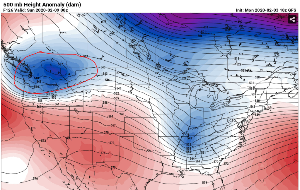
Really like what i see so far for the Sunday threat on 12Z so far. IMO this threat goes right to the coast. The cold air is much deeper compliments of -EPO and the departing storm on Friday. This sets the stage for a nice overrunning air mass. The other important aspect is the low slides underneath us. 2 critical aspects we just haven't had for most of the winter.
Blockbuster storm? No as we don't have the sharp trough in place for that and no blocking, but it's got a good supply of gulf moisture at the 700mb right to Gulf of Mexico as it approaches. That and the cold air are what is needed.
Hmm. Not fully committed as it's too early, but interesting.
[Edited]
One fly in the proverbial ointment is the western ridge. If that thing gets knocked down by the trough, then it's going to make for a very flat wave that passes off the coast. Much less of a "event" if that indeed does occur. We shall see.

Last edited by heehaw453 on Mon Feb 03, 2020 5:20 pm; edited 2 times in total
heehaw453- Advanced Forecaster

- Posts : 3906
Reputation : 86
Join date : 2014-01-20
Location : Bedminster Township, PA Elevation 600' ASL
Page 23 of 28 •  1 ... 13 ... 22, 23, 24 ... 28
Page 23 of 28
Permissions in this forum:
You cannot reply to topics in this forum|
|
|

 Home
Home