
 Search
Current date/time is Fri Apr 26, 2024 7:15 pm
Search found 41 matches for 2
FEB 13th Pre V-Day Storm Part II
CPcantmeasuresnow wrote:Can we call this one of the biggest model fails within 24 hours of a storm in the last ten years at least. The event hadn't happened yet but it's on its way to being that. I at least hope all in NYC and south cash in good.
I would say yes but even worse going back more than 24 hours. If you go back to last Thursday the models had everything from a statewide NJ rainstorm with heavy snow in the mid-HV and NE, to Heavy Snow across the Delmarva to South Jersey with no snow north of NYC; and every solution in between. Worse yet, each model at various points in time presented all of those diverse outcomes, so none were consistent.
The models served two purposes in this case:
1. To confirm there was a storm
2. To confirm that any solution was possible.
I guess there is some value in #1, but very little in #2.
In fact, I guess to pat us on the back, I’d say our guys on here gave more consistent and valuable input/analysis than all the models combined.
- on Mon Feb 12, 2024 9:44 pm
- Search in: Official Weather Talk Thread
- Topic: FEB 13th Pre V-Day Storm Part II
- Replies: 364
- Views: 15612
JAN 28th-30th 2024 Potential system compliments of a +PNA
This is for Irish....Im a man of my word.
Ok here is the set up for the potential for the28th-30th time frame. As has been stated a few times already, a stout +PNA(ridge along the WC of NA), ridge will give rise to the potential. It cant be stressed enough that this is in the face of an otherwise shitty pattern so alot has to come together just right for it to work out. And work out for whom. Obv the coastal plain has the hardest time with temp profiles, where as off the coast may deal with a subsidence zone. Although keep in mind we all will have to worry about temp profiles to one degree or another.
As of 6z GFS this am here is the two main energies at 500mb (18-20k ft). Labeled 1 & 2. #1 is the energy in the Pac jet which we will call the southern stream (s/s) energy and will give rise to our system, and #2 will create an arctic/polar High Pressure (HP) that will be critical for this set up for providing a cold air source.
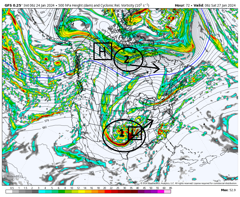
As you can see both pieces will dig into these two approx locations by hr 72, approx 3 days from now.
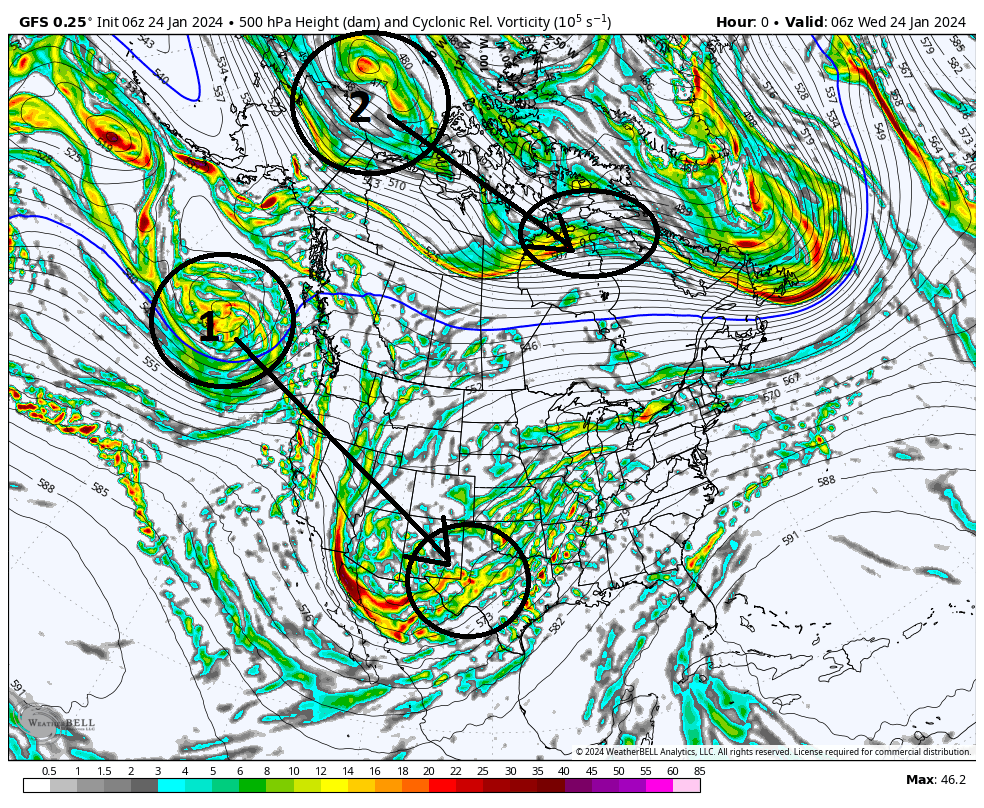
As you can now see in below image the energies are in position. From here 1 & 2 head off in the direction indicated by the arrow.
(see below) At the surface, the result of #1 is the development of a surface LP somewhere out ahead of the 500mb energy, and the result of #2 in its position is an HP developing in it's wake.
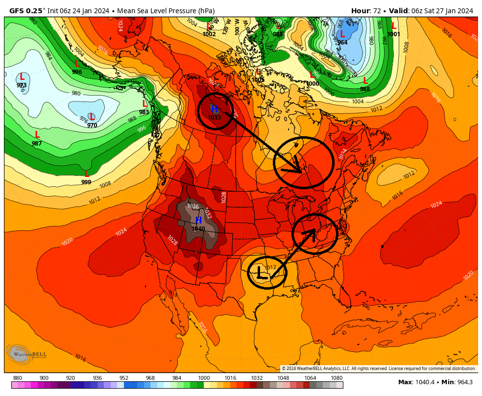
Now quickly look back at the surface map above because this becomes a critical crossroads as we move forward. The surface LP will now heads towards the Ohio/Tenn Valleys, while the HP dives into SE Canada. Simply stated, in essence the overall outcome of this potential will be dictated by the exact timing, strength, and positioning of these two main features. It becomes a race to see who can get into position first, the HP or the LP, to determine how much cold air is available, and when and where.
(Now see below) The primary LP(P LP) will cut towards the Ohio and Tenn valley. In the latest GFS run it takes the P LP north into Western Pa before transferring off the Atlantic coast, and from there the Primary deepens and heads NE.
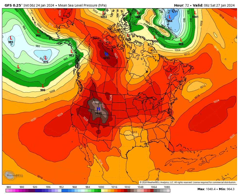
So to summerize:
1) How strong and How quickly the HP moves in to our north will dictate how far north and west our Primary LP can track before being forced to transfer to the coast.(by the way this is what a Miller B set up is...a cutting primary with a secondary LP transfer to the coast)
AND...
2) How strong and positioning of the HP also tells us how much cold air is available for the system.
CURRENTLY ON THE MODELS: ---Pay attention to HP strength ad placement---
GFS = Cuts furthest north(western PA/E Ohio) before transfer therefore secondary LP too close to the coast and only aeas furthest N&W will be cold enough to snow
CMC = Primary only makes it to W Va before transferring to the coast
Euro = notice its HP position and strength compared to GFS and CMC. Its very late to the party with the HP, but the southern energy takes a more direct route through the eastern Tenn valley, straight to the coast instead of a true Miller B where it cuts west; then transfer of energy to the coast. This will keep the coastal plain warm because of the Antecedent Air mass in place at least per 00z run verbatim.

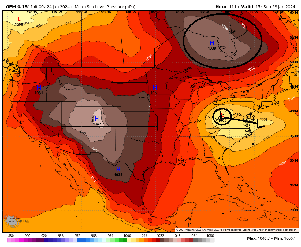

So as you can see there is still much uncertainty in the exact evolution of some of the key players. There are still big picture details that are still unclear. As we all know small changes at 500mb can have large impacts on how the surface features play out. Like pretty much any winter storm, the exact IMBY details will likely not be ironed out until within 24-48hrs.
We Track!
- on Wed Jan 24, 2024 8:31 am
- Search in: Official Weather Talk Thread
- Topic: JAN 28th-30th 2024 Potential system compliments of a +PNA
- Replies: 120
- Views: 5939
Long Range Thread 28.0
Ok here is the set up for the potential for the28th-30th time frame. As has been stated a few times already, a stout +PNA(ridge along the WC of NA), ridge will give rise to the potential. It cant be stressed enough that this is in the face of an otherwise shitty pattern so alot has to come together just right for it to work out. And work out for whom. Obv the coastal plain has the hardest time with temp profiles, where as off the coast may deal with a subsidence zone. Although keep in mind we all will have to worry about temp profiles to one degree or another.As of 6z GFS this am here is the two main energies at 500mb (18-20k ft). Labeled 1 & 2. #1 is the energy in the Pac jet which we will call the southern stream (s/s) energy and will give rise to our system, and #2 will create an arctic/polar High Pressure (HP) that will be critical for this set up for providing a cold air source.
As you can see both pieces will dig into these two approx locations by hr 72, approx 3 days from now.
As you can now see in below image the energies are in position. From here 1 & 2 head off in the direction indicated by the arrow.
(see below) At the surface, the result of #1 is the development of a surface LP somewhere out ahead of the 500mb energy, and the result of #2 in its position is an HP developing in it's wake.
Now quickly look back at the surface map above because this becomes a critical crossroads as we move forward. The surface LP will now heads towards the Ohio/Tenn Valleys, while the HP dives into SE Canada. Simply stated, in essence the overall outcome of this potential will be dictated by the exact timing, strength, and positioning of these two main features. It becomes a race to see who can get into position first, the HP or the LP, to determine how much cold air is available, and when and where.
(Now see below) The primary LP(P LP) will cut towards the Ohio and Tenn valley. In the latest GFS run it takes the P LP north into Western Pa before transferring off the Atlantic coast, and from there the Primary deepens and heads NE.
So to summerize:
1) How strong and How quickly the HP moves in to our north will dictate how far north and west our Primary LP can track before being forced to transfer to the coast.(by the way this is what a Miller B set up is...a cutting primary with a secondary LP transfer to the coast)
AND...
2) How strong and positioning of the HP also tells us how much cold air is available for the system.
CURRENTLY ON THE MODELS: ---Pay attention to HP strength ad placement---
GFS = Cuts furthest north(western PA/E Ohio) before transfer therefore secondary LP too close to the coast and only aeas furthest N&W will be cold enough to snow
CMC = Primary only makes it to W Va before transferring to the coast
Euro = notice its HP position and strength compared to GFS and CMC. Its very late to the party with the HP, but the southern energy takes a more direct route through the eastern Tenn valley, straight to the coast instead of a true Miller B where it cuts west; then transfer of energy to the coast. This will keep the coastal plain warm because of the Antecedent Air mass in place at least per 00z run verbatim.
So as you can see there is still much uncertainty in the exact evolution of some of the key players. There are still big picture details that are still unclear. As we all know small changes at 500mb can have large impacts on how the surface features play out. Like pretty much any winter storm, the exact IMBY details will likely not be ironed out until within 24-48hrs.
We Track!
- on Wed Jan 24, 2024 8:22 am
- Search in: Official Weather Talk Thread
- Topic: Long Range Thread 28.0
- Replies: 429
- Views: 24160
December 2023 Observations and Discussion
sroc4 wrote:I was debating “weather” to post this in banter or observations thread. I decided here because the image below pretty much sums up most of our observations over the last few years.
I hope everyone has a very Merry Christmas….Buon Natale!!
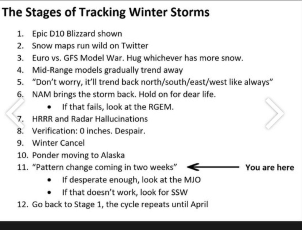
Oh my goodness, so funny…and so accurate! My personal favorite is #1, and #2, and really #3-6 also.
Merry Christmas to all and to all an actually and imminently occurring pattern change for the better!!!
- on Mon Dec 25, 2023 11:21 am
- Search in: Official Weather Talk Thread
- Topic: December 2023 Observations and Discussion
- Replies: 268
- Views: 10277
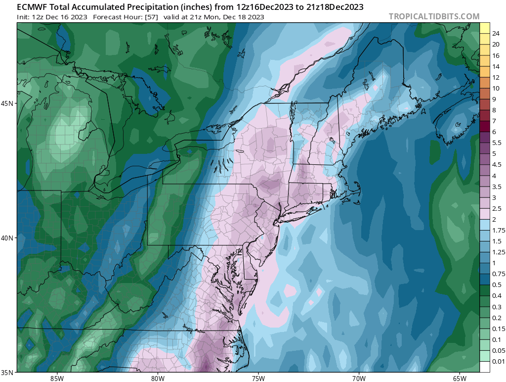
DEC 18th-20th 2023--Wet, White, Wind?
Frank_Wx wrote:deadrabbit79 wrote:Frank_Wx wrote:I think we’re looking at 2-3” of rain and gusts as high as 45mph for NYC and areas just N&W. Areas east of NYC probably same rainfall amounts but a bit more wind. I think they’ll mix down more than what we saw last storm, but I also don’t believe the extreme winds some models show of 70+ mph (can’t discount this on the island though).
Rain is poised to start tomorrow afternoon. Probably after 3pm. Heaviest comes after midnight into Monday morning.
With regards the rain and the amounts….2-3 inches SEEMS manageable for most. #1 any Chance of deluge type rainfalls like we got with the September 29th and October 7th storms where some got 4,5,6 inches? #2 are we helped out at all by the fact that this rainfall seems to come over a 15-18 hour timeframe?
I kinda like how the EURO depicts rainfall for this storm. The mean is 2-3” with pockets of more than 3” over areas where heavier bands set up. The upper level low does not stay closed off. By the time it reaches the Delmarva it becomes an open wave which allows vorticity to escape east.
I know Ray discussed this..but…this was very close to being a widespread blizzard for the area. Makes me want to puke thinking about it. Oh well. Onto the next one
Looks like the soaking rainstorm is going to happen.Could be up to 5 inches here in the LHV.
I don't feel too bad about this not being snow seeing it will be heavy rain all the way through Maine.A real kick in the head would be seeing 30 inches of snow in Central NY with heavy rain here.
Very close for an epic snowstorm but this pattern that has set up since Nov. 1 is relentless.Hopelfully, this storm shakes things up.Looming large here is "as December goes, so goes the winter"!
- on Sun Dec 17, 2023 6:26 am
- Search in: Official Weather Talk Thread
- Topic: DEC 18th-20th 2023--Wet, White, Wind?
- Replies: 247
- Views: 8678
DEC 18th-20th 2023--Wet, White, Wind?
Frank_Wx wrote:deadrabbit79 wrote:Frank_Wx wrote:I think we’re looking at 2-3” of rain and gusts as high as 45mph for NYC and areas just N&W. Areas east of NYC probably same rainfall amounts but a bit more wind. I think they’ll mix down more than what we saw last storm, but I also don’t believe the extreme winds some models show of 70+ mph (can’t discount this on the island though).
Rain is poised to start tomorrow afternoon. Probably after 3pm. Heaviest comes after midnight into Monday morning.
With regards the rain and the amounts….2-3 inches SEEMS manageable for most. #1 any Chance of deluge type rainfalls like we got with the September 29th and October 7th storms where some got 4,5,6 inches? #2 are we helped out at all by the fact that this rainfall seems to come over a 15-18 hour timeframe?
I kinda like how the EURO depicts rainfall for this storm. The mean is 2-3” with pockets of more than 3” over areas where heavier bands set up. The upper level low does not stay closed off. By the time it reaches the Delmarva it becomes an open wave which allows vorticity to escape east.
I know Ray discussed this..but…this was very close to being a widespread blizzard for the area. Makes me want to puke thinking about it. Oh well. Onto the next one
A 1040+ mb H parked over Quebec pinned by 50/50 L which is pinned by -NAO yeah I think this would be pushing much more east and we'd in nirvana with this one. You don't have H and I say again the NAM state ruined this one for us...
- on Sat Dec 16, 2023 4:12 pm
- Search in: Official Weather Talk Thread
- Topic: DEC 18th-20th 2023--Wet, White, Wind?
- Replies: 247
- Views: 8678
DEC 18th-20th 2023--Wet, White, Wind?
deadrabbit79 wrote:Frank_Wx wrote:I think we’re looking at 2-3” of rain and gusts as high as 45mph for NYC and areas just N&W. Areas east of NYC probably same rainfall amounts but a bit more wind. I think they’ll mix down more than what we saw last storm, but I also don’t believe the extreme winds some models show of 70+ mph (can’t discount this on the island though).
Rain is poised to start tomorrow afternoon. Probably after 3pm. Heaviest comes after midnight into Monday morning.
With regards the rain and the amounts….2-3 inches SEEMS manageable for most. #1 any Chance of deluge type rainfalls like we got with the September 29th and October 7th storms where some got 4,5,6 inches? #2 are we helped out at all by the fact that this rainfall seems to come over a 15-18 hour timeframe?
I kinda like how the EURO depicts rainfall for this storm. The mean is 2-3” with pockets of more than 3” over areas where heavier bands set up. The upper level low does not stay closed off. By the time it reaches the Delmarva it becomes an open wave which allows vorticity to escape east.
I know Ray discussed this..but…this was very close to being a widespread blizzard for the area. Makes me want to puke thinking about it. Oh well. Onto the next one
- on Sat Dec 16, 2023 3:14 pm
- Search in: Official Weather Talk Thread
- Topic: DEC 18th-20th 2023--Wet, White, Wind?
- Replies: 247
- Views: 8678
DEC 18th-20th 2023--Wet, White, Wind?
Frank_Wx wrote:I think we’re looking at 2-3” of rain and gusts as high as 45mph for NYC and areas just N&W. Areas east of NYC probably same rainfall amounts but a bit more wind. I think they’ll mix down more than what we saw last storm, but I also don’t believe the extreme winds some models show of 70+ mph (can’t discount this on the island though).
Rain is poised to start tomorrow afternoon. Probably after 3pm. Heaviest comes after midnight into Monday morning.
With regards the rain and the amounts….2-3 inches SEEMS manageable for most. #1 any Chance of deluge type rainfalls like we got with the September 29th and October 7th storms where some got 4,5,6 inches? #2 are we helped out at all by the fact that this rainfall seems to come over a 15-18 hour timeframe?
- on Sat Dec 16, 2023 2:56 pm
- Search in: Official Weather Talk Thread
- Topic: DEC 18th-20th 2023--Wet, White, Wind?
- Replies: 247
- Views: 8678
Tropical Storm (Hurricane?) Ophelia
Interested to see if we have some localized flooding issues tomorrow. Plenty of rain today with round one and the ground is saturated to the max, as are rivers and streams. Round two tomorrow could still pack a punch with rainfall, and there isn’t really anywhere for the excess water to go. As you see below #1 was todays rain, but #2 is tomorrow’s round.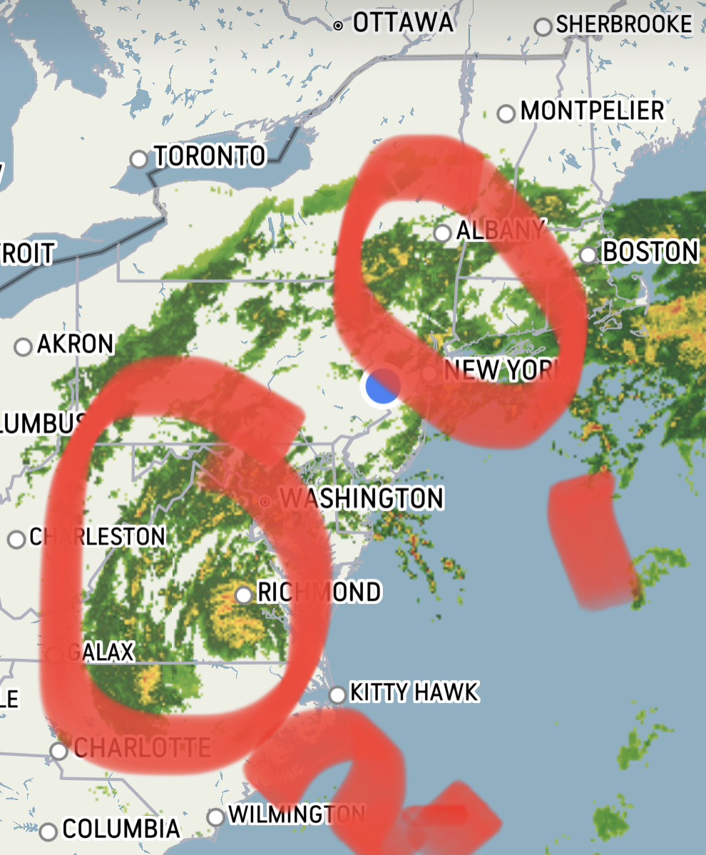
- on Sat Sep 23, 2023 6:49 pm
- Search in: Official Weather Talk Thread
- Topic: Tropical Storm (Hurricane?) Ophelia
- Replies: 79
- Views: 3571
February 27th-28th 2023 Winter Storm
billg315 wrote:MattyICE wrote:Some things I like to remind myself of as we get closer:
1) latent heat release. This storm is producing quite a bit of convection out in Illinois. This can pump things out ahead a little bit. We look for this factor when storms are modeled to far out to sea to try to nudge the system more N and W. No idea if this will come into play but could be a wildcard for fringe spots.
2) speed and duration. This likely comes in ahead of schedule and lasts more quickly than we think it might and ends quicker. Think of how many times one model or another made it look like it would precipitate hours longer than it ended up. I think any appreciable accumulating snows are done by daybreak.
3) what falls from the sky may not be what accumulates. 6 inches could fall. But how much melts initially. How much gets compacted with snow that is more wet than powdery and does qpf get wasted on sleet? All of that can result in 2.5 inches of slush and yet a 3-6 call would have still been accurate
There’s probably more but regardless many their first real snow tonight! I do think from 80ish on north is going to end up doing quite well.
#2 is a persistent pet peeve of mine. Models love to indicate long, drawn out events that in reality end much more abruptly once the storms begin to accelerate northeast.
Except this storms trajectory is ESE; not NE. Same difference though. It almost always begins at or earlier than modeled and def finishes earlier
- on Mon Feb 27, 2023 12:25 pm
- Search in: Official Weather Talk Thread
- Topic: February 27th-28th 2023 Winter Storm
- Replies: 248
- Views: 13773
February 27th-28th 2023 Winter Storm
MattyICE wrote:Some things I like to remind myself of as we get closer:
1) latent heat release. This storm is producing quite a bit of convection out in Illinois. This can pump things out ahead a little bit. We look for this factor when storms are modeled to far out to sea to try to nudge the system more N and W. No idea if this will come into play but could be a wildcard for fringe spots.
2) speed and duration. This likely comes in ahead of schedule and lasts more quickly than we think it might and ends quicker. Think of how many times one model or another made it look like it would precipitate hours longer than it ended up. I think any appreciable accumulating snows are done by daybreak.
3) what falls from the sky may not be what accumulates. 6 inches could fall. But how much melts initially. How much gets compacted with snow that is more wet than powdery and does qpf get wasted on sleet? All of that can result in 2.5 inches of slush and yet a 3-6 call would have still been accurate
There’s probably more but regardless many their first real snow tonight! I do think from 80ish on north is going to end up doing quite well.
#2 is a persistent pet peeve of mine. Models love to indicate long, drawn out events that in reality end much more abruptly once the storms begin to accelerate northeast.
- on Mon Feb 27, 2023 12:17 pm
- Search in: Official Weather Talk Thread
- Topic: February 27th-28th 2023 Winter Storm
- Replies: 248
- Views: 13773
Long Range Thread 25.0
heehaw453 wrote:I'll say one more thing on the Monday storm. A setup what Euro is showing would be 6"+ snow for I95 on a decent year. One where there was cold air around. But this year is another animal as y'all know. The only thing that can give I95 a shot for a few weeks is the TPV placement and movement. But until you get your first snowfall skepticism must remain. NYC will very likely be #2 in the longest its taken for measurable snowfall and yes it's possible it beats the January 28 date, albeit I think something works out before that date. Some how some way...
Will continue to go with the mindset of what we use to refer to as winter. “Expect little, get even less”
- on Thu Jan 19, 2023 9:00 am
- Search in: Official Weather Talk Thread
- Topic: Long Range Thread 25.0
- Replies: 985
- Views: 83067
Long Range Thread 25.0
I'll say one more thing on the Monday storm. A setup what Euro is showing would be 6"+ snow for I95 on a decent year. One where there was cold air around. But this year is another animal as y'all know. The only thing that can give I95 a shot for a few weeks is the TPV placement and movement. But until you get your first snowfall skepticism must remain. NYC will very likely be #2 in the longest its taken for measurable snowfall and yes it's possible it beats the January 28 date, albeit I think something works out before that date. Some how some way...- on Thu Jan 19, 2023 6:58 am
- Search in: Official Weather Talk Thread
- Topic: Long Range Thread 25.0
- Replies: 985
- Views: 83067
Dec 16 Just a little change can make the difference
Double Barrel LP?? Huh? It does not make sense in this set up, if you take this further east to #2 it is in with the GFS camp. Is it real though?
- on Wed Dec 14, 2022 1:51 pm
- Search in: Official Weather Talk Thread
- Topic: Dec 16 Just a little change can make the difference
- Replies: 175
- Views: 11257

- on Tue Sep 27, 2022 9:42 pm
- Search in: Official Weather Talk Thread
- Topic: Tropics
- Replies: 468
- Views: 26333
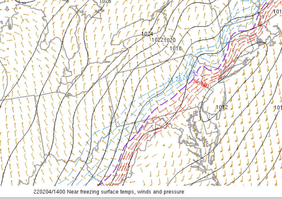
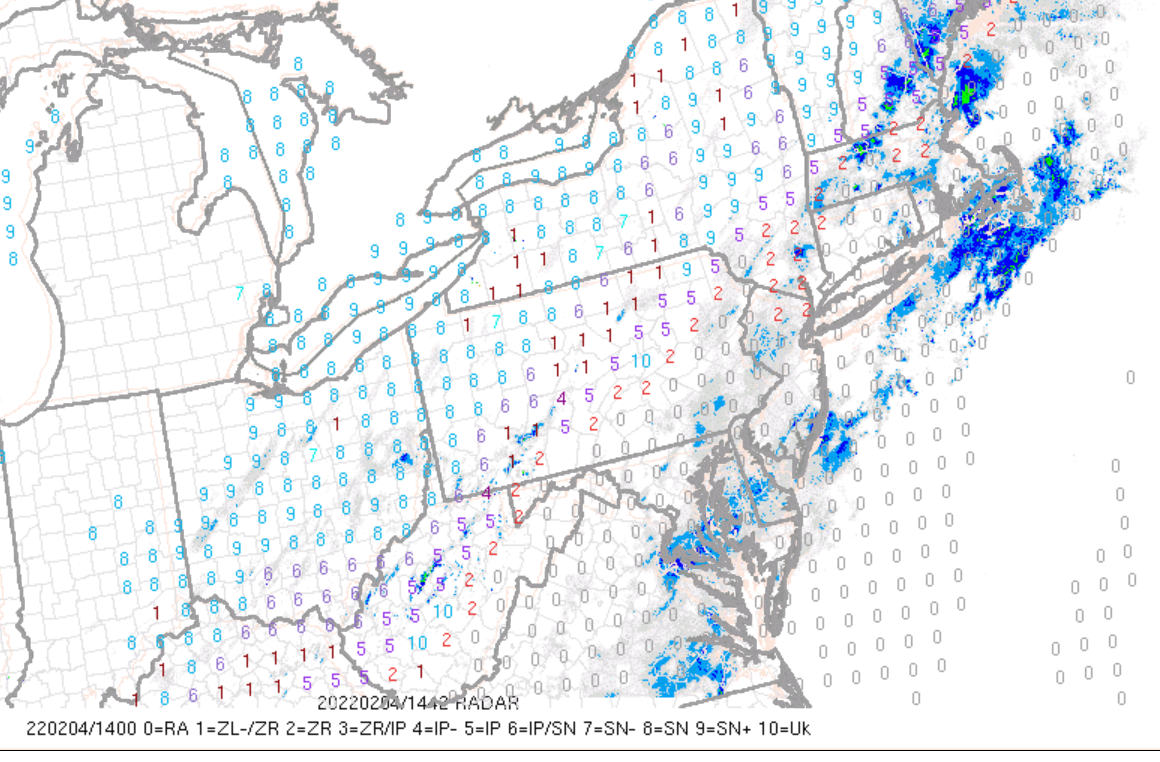
Monitoring February 4th
Frank_Wx wrote:As many have noted temperatures are quickly crashing and there's still a decent amont of precip left to fall.
http://moe.met.fsu.edu/~mnissenbaum/RadarArchive/KDIX/loop.html
The near-surface temps are at or below freezing across NW and extreme NNJ, and obviously already below freezing N&W of NYC.
Real-time obs show freezing rain falling in those areas, as indicated by the #2
The freezing rain line will probably sag a bit more south, but precip should shut off by Noon
Here’s an update on the freezing line. Hasn’t really moved south that much…
It

- on Fri Feb 04, 2022 12:09 pm
- Search in: Official Weather Talk Thread
- Topic: Monitoring February 4th
- Replies: 316
- Views: 15963
Monitoring February 4th
As many have noted temperatures are quickly crashing and there's still a decent amont of precip left to fall.http://moe.met.fsu.edu/~mnissenbaum/RadarArchive/KDIX/loop.html
The near-surface temps are at or below freezing across NW and extreme NNJ, and obviously already below freezing N&W of NYC.
Real-time obs show freezing rain falling in those areas, as indicated by the #2
The freezing rain line will probably sag a bit more south, but precip should shut off by Noon
- on Fri Feb 04, 2022 9:55 am
- Search in: Official Weather Talk Thread
- Topic: Monitoring February 4th
- Replies: 316
- Views: 15963
- on Mon Jan 03, 2022 8:30 pm
- Search in: Official Weather Talk Thread
- Topic: January 2022 Obs & Discussions
- Replies: 455
- Views: 16877
- on Mon Jan 03, 2022 8:18 pm
- Search in: Official Weather Talk Thread
- Topic: January 2022 Obs & Discussions
- Replies: 455
- Views: 16877
DECEMBER 8TH 2021---First real accumulating snow potential ????
rb924119 wrote:Now that I've had a chance to glance at tonight's 00z suites coming in, I like the trends aloft even though the surface maps are not yet where I think they will end up.
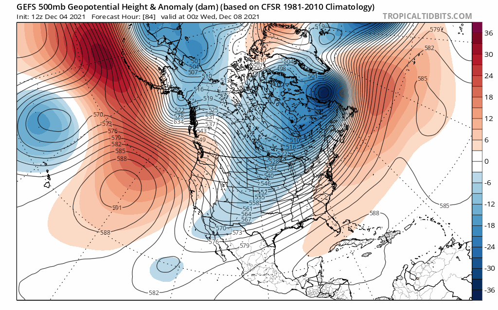
00z GFS Ensemble 500mb height anomaly trend:
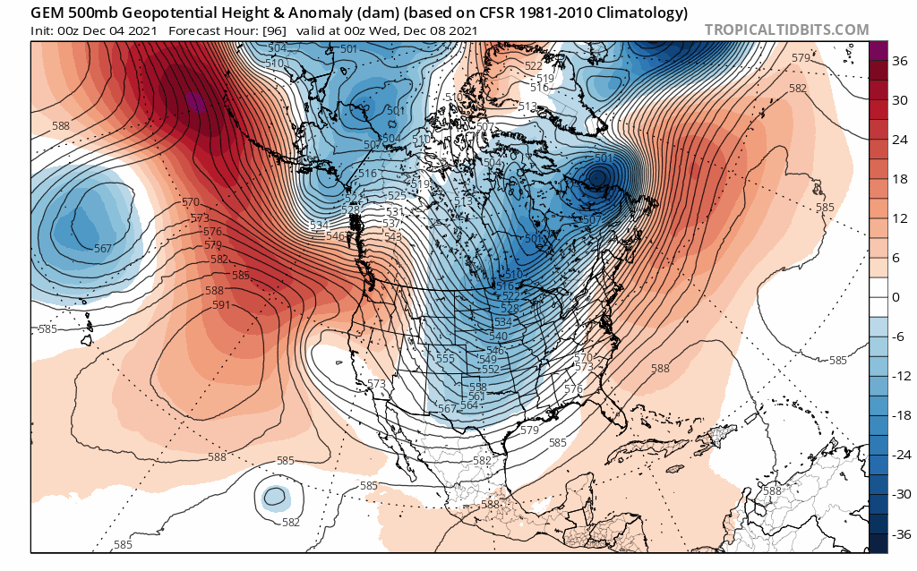
00z GEM/CMC 500mb height anomaly trend:
Morning everyone!!!!! Here is the Link to Rays video he posted in the Discussions thread. I encourage everyone to take a listen. Its phenominal:
https://drive.google.com/file/d/1gonDCUaWVuA3Grk8Khi_qgno0tRQHRm5/view?usp=sharing
Ray phenomenal video! Thank you. I wish I could do video's too. I feel like it would save me so much time. I am; however, going to have to respectfully disagree with a couple of points you make. Well maybe not disagree but more point out a few key areas that I did not see you comment on and what I feel are just as important, if not more important.
I will focus on the GFS only to make my points. Some of this was already discussed in my last write up. Ray in your video you discuss the trough split of the Pac energy and discuss the piece ejecting out vs the piece that backs up off the WC. It felt like you were inferring that the energy that gets ejected ends up being the energy that is our system. This part I disagree with.
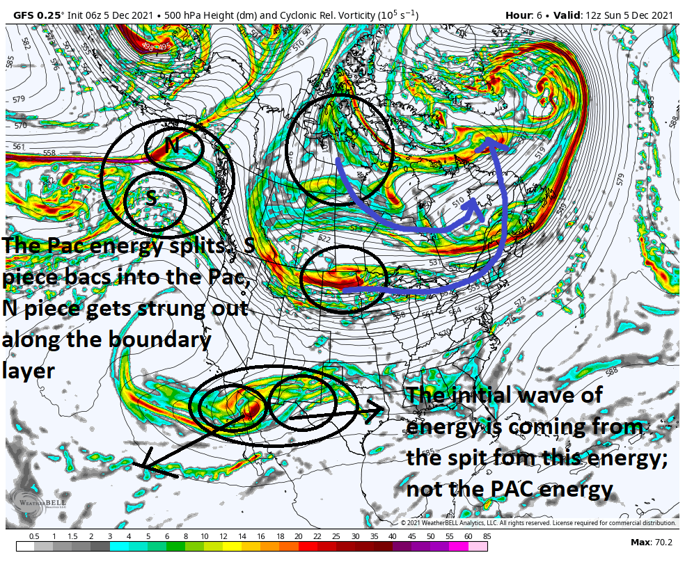
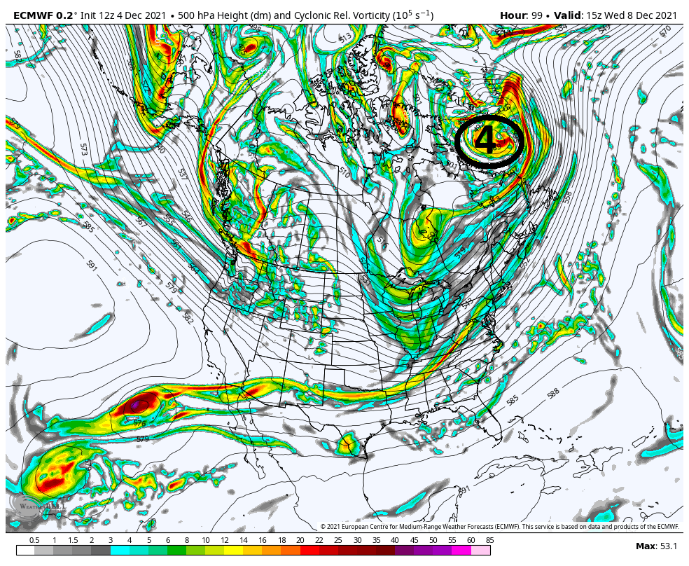
Above is hr6, or about 7am this am, from this am's 06z GFS. In addition to the trough split from the Pac energy as outlined in the video, there is a second trough split associated with the trough in the Sub Trop region. Its this energy that gets ejected that will eventually give rise to the LP that develops near or just off the coast. The energy that gets ejected from the Pac energy ends up strung out along the boundary layer that develops from the system that passes late tomorrow night. The other area not mentioned in the video are the two circles not labeled. The one over the N plains CONUS is the late Mon system that heads towards Greenland. The one to its N is another key factor IMHO that I mentioned in my prior discussion. Ill get back to this point shortly
Fast forward to Hr 72:

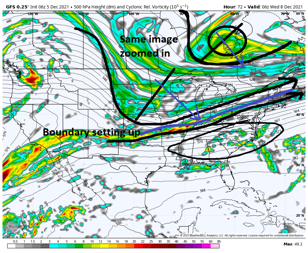
Above is the same image zoomed in on the CONUS view. Notice that there ae two troughs out lined. One N of th GL and the other digging into the plains. Each has its own pivot point. What seems to be very clear to me in the evolution in the modeling is the positioning of that trough N of the great lakes. This feature is absolutely vital in preventing heights from increasing ahead of the system.
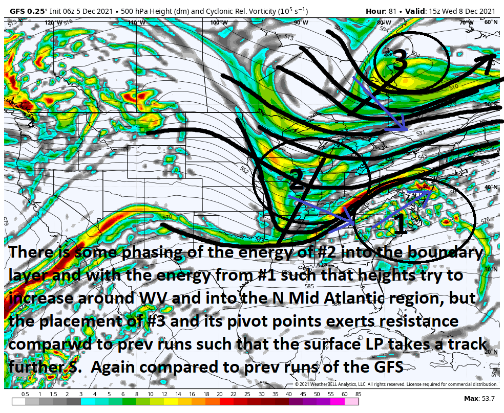
Look below to Hr 81 on this mornings 6z. BUT FIRST lets look at the same time stamp Wed 15z from yesterdays 12z GFS that I posted in my prev discussion and compare it to this mornings 06z run and pay attention to where that trough N of the GL is. With it further east and north on yesterdays 12z run there is no resistance to the height increase from the trough digging into the Plains phasing into the boundary layer. The result is a LP track into the Tenn Vally, and a much warmer soln on yest 12z. Vs the 6z from this am the placement of the GL trough is acting to limit the ability to raise heights leading to a colder soln relatively speaking when comp to12z yest.
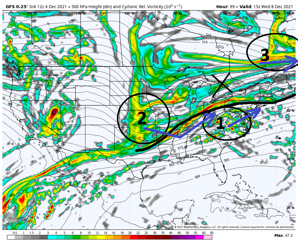


Briefly getting back to this point I made at the beginning of todays discussion:
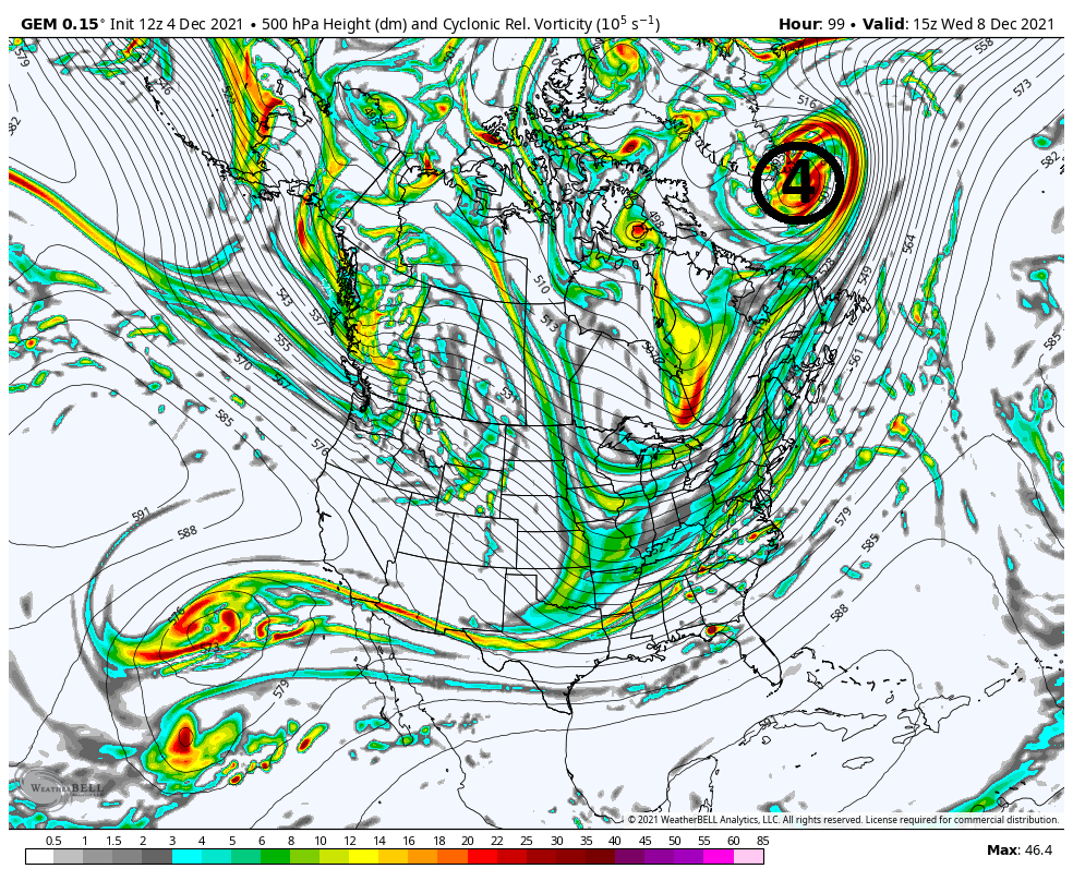
The other area not mentioned in the video are the two circles not labeled. The one over the N plains CONUS is the late Mon system that heads towards Greenland. The one to its N is another key factor IMHO that I mentioned in my prior discussion.
The trend for the Monday system is to be further S from prev. First image is yesterdays 12z map and the second is this mornings 6z both valid for 15z Wed.
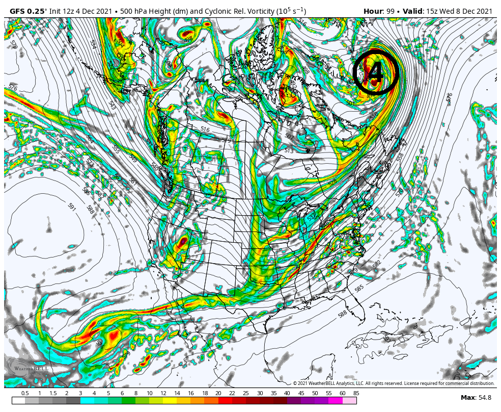
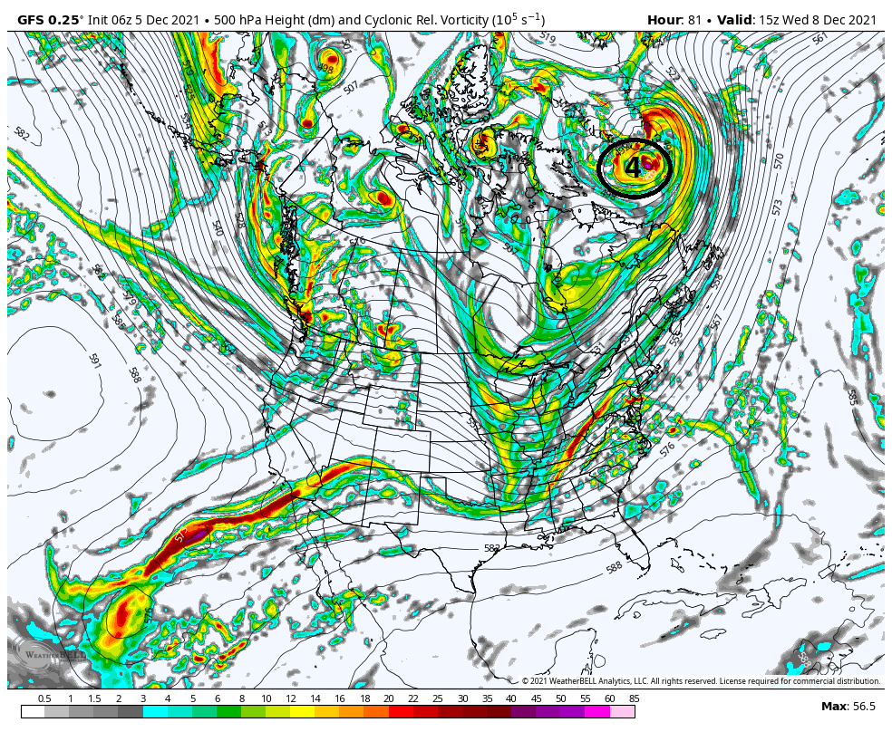
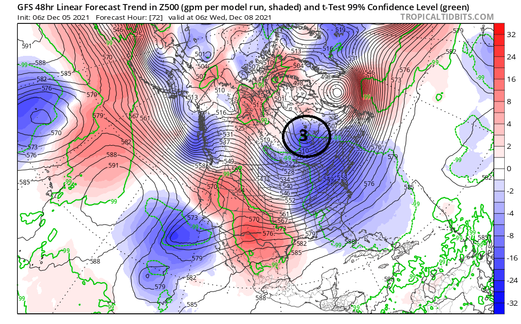
You can see the center is now south of Greenland's SE tip compared to yesterdays 12z run where it was due east of Greenland's SE tip. In addition to that, look at the map below. It shows the GFS trends. The area I have circled is the energy I have labeled #3 in the discussion maps above and you can clearly see it is trending darker blue which means lower pressure in the area just N of the GL. Again this energy/feature offers the only resistance against the otherwise immediate surge of the warm layers as energy #2 phases with #1 because both the Pac and Atlantic pattern does not offer any real help at all.
Myself, Ray(rb, Frank, Heehaw, Mugsy, Al etc., have all pointed out that we are not in a great pattern for snow. But as I have also pointed out in the past, it can still snow in shitty patterns when things come together just right. We just need BABY BEAR. (My Baby Bear here on Long Island may be slightly diff than Baby bear N&W of NYC, but you get the point)
We still have a little ways to go to see how we trend last minute. The GFS is def still the warmest and wettest soln but it is on its own at the moment and has 100% been trending colder due to the things I outlined above. The Euro, CMC, and now NAM(although NAM still not in its wheelhouse yet) all have a much more suppressed colder soln overall. To me the trend towards a colder soln has been clear across all models, keeping the entire region, including the immediate coast in play for accumulation, but remember very tiny changes at 500mb can lead to much larger changes at the surface for better or worse (warmer or colder)(wetter or dryer-OTS) relative to your specific location so stay tuned as we are approaching game time.
WE TRACK!!!!!

- on Sun Dec 05, 2021 9:03 am
- Search in: Official Weather Talk Thread
- Topic: DECEMBER 8TH 2021---First real accumulating snow potential ????
- Replies: 44
- Views: 4187
December 2021 Obs and Discussion
heehaw453 wrote:Many op models showing a fairly stationary 1030mb+ High parked over Southern Quebec. I don't think this is going to be suppressed and OTS with a decent WAR. That gives the coastal plain a chance at some snow if that high pressure is correct. The antecedent air mass is good for early December on this and I can tell you that high pressure CAD is often under modelled. It will depend on how far away from the coast the storm consolidates. Once again though NW of 95 are in a threat for several inches of snow especially I-80 and above.
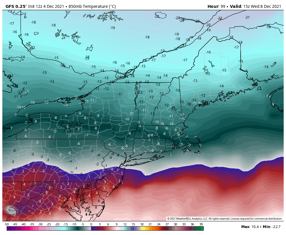
Looking at 500 you can see why that makes sense and why the GFS still has the HP retreating quickly, and is warmest soln, the Euro is the most suppressed and coldest soln, and the CMC is in between.
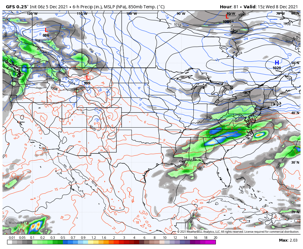
Here are the three global models at 500mb on approach and their respective surface depiction for the same time stamp. All valid for 15z Wed, or 10am Wed. Euro, CMC, and GFS.
The set up is such that a boundary layer will set up after the Late Mond system passes NW and drags the front through. Along the frontal boundary weak LP will develop, black circle #1, and ride along it. On the GFS you can see the result of #3 so far east and # 2 so far S&W relative to one another and the fact that #1 is out in front of #2 allows the boundary layer to set up furthest N of all solns.
The euro on the other hand is the other side of the soln cone where the proximity of both #3 to #2, forces the boundary much further S&E.
The positioning of #1, #2, an #3 relative to each other is in between the GFS an Euro.
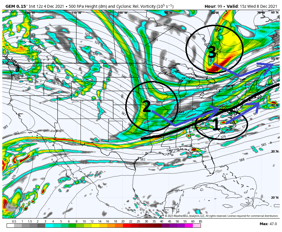
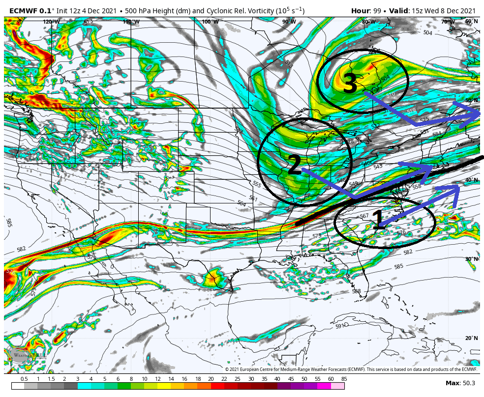
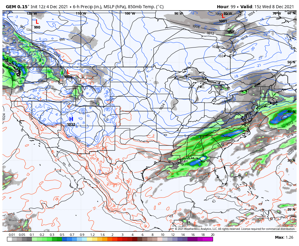
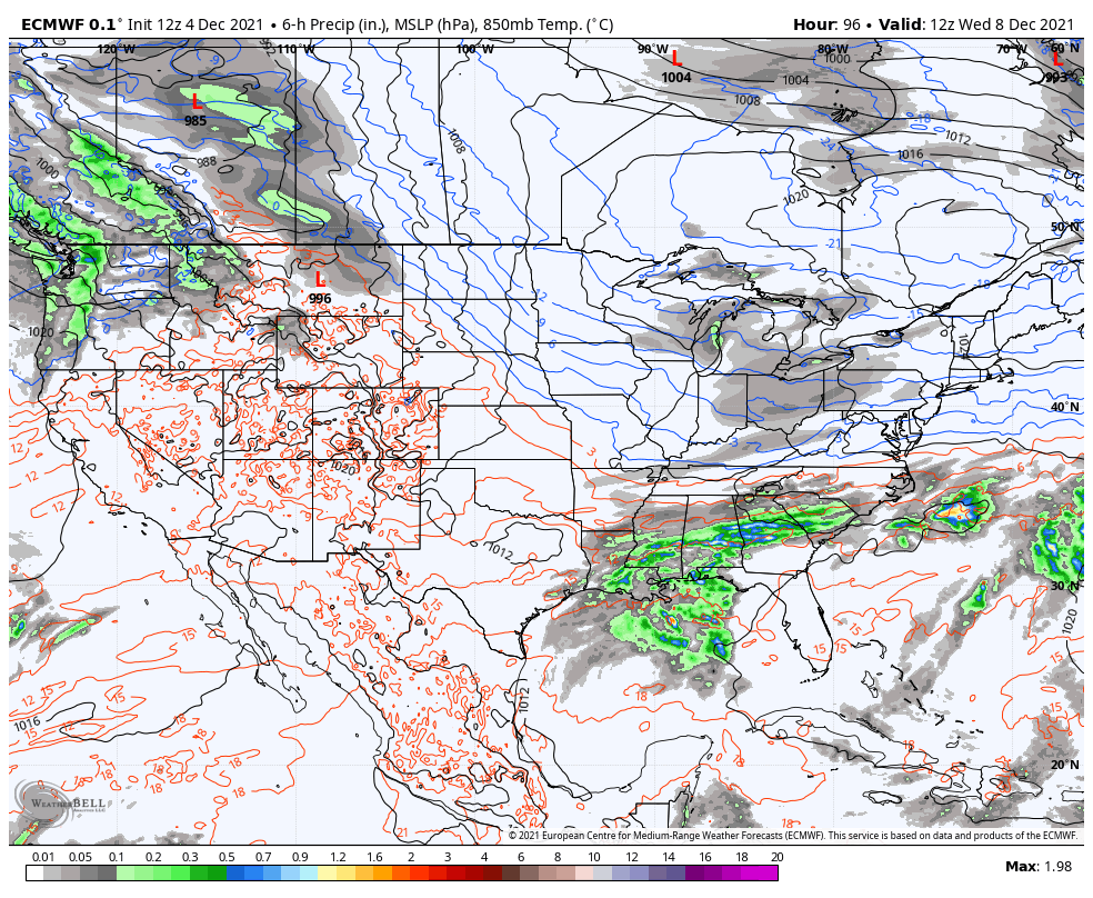
So if you look at the GFS as the current warmest soln, and the Euro as the coldest soln, very very commonly the final soln lies somewhere in between which def bodes well for most of us to see some white gold at least, and areas N&W in line for accumulation.
Just briefly below I expanded the 500mb view to see the location of where the system that passes Mondayends up. Again, GFS furthest N which allows our HP to escape faster, hence the warmer soln. Euro is the furthest S, and CMC in between.
Im getting a little excited.
WE TRACK!!!!
- on Sat Dec 04, 2021 2:23 pm
- Search in: Official Weather Talk Thread
- Topic: December 2021 Obs and Discussion
- Replies: 151
- Views: 10420
November 2021 Obs & Discussions
From a pro met who outlines each storm potentialThe blocking is gonna be real folks and the first two storms will be disruptive to the holiday travel timeframe from the looks of it.
STORM #! - Great Lakes, Ski Resort area on NE too far west Apps runner

This storm will help pump the Negative NAO
STORM #2
Miller B style that will have more of an effect on NE and may get snows into the elevated regions of the Tri State - back end snows at end of storm into the coast possible but we know how that plays out.
This sets up Storm#3 possibilities
- on Wed Nov 17, 2021 8:32 am
- Search in: Official Weather Talk Thread
- Topic: November 2021 Obs & Discussions
- Replies: 186
- Views: 11615
February 2021 Observations and Discussions
CPcantmeasuresnow wrote:Went down from 14 inches otg yesterday morning to 10.5 otg this morning. This morning becomes my first day with less than a foot otg this month.
It was a really good 24 day run but not fantastic, like I've never seen, historic, or any of the other hyperbole you may read. If somehow this is it for winter, February gets an A+ and the winter as a whole gets a C. Hopefully March delivers in the HV as it usually does, then I'll adjust the grade accordingly. The first week of March is not promising at this stage.
From the imby perspective, this fairly well describes my winter too. Accumulating snow in March is prob more normal than not on a year by year basis down here, but at present I’m figuring that’s a wrap for this year.
Major theme: Snowfall returns!
Minor theme #1: A Ferocious February! (Technically, not a true statement imby, as my highest measurement was actually 5+” on Jan 31, but by Wxecutive Order, that counts towards Feb for this year.)
Minor theme #2: Big time near misses for Coastal Ocean.
My overall grade at this point probably a B, a lot better than the D and F from the previous two years.
The tracking this winter has been amazing too! What a show you guys have put on for us winter weenies!! Thank you so much for the time put in and expertise/wisdom shared!
- on Thu Feb 25, 2021 9:22 am
- Search in: Official Weather Talk Thread
- Topic: February 2021 Observations and Discussions
- Replies: 134
- Views: 7894
Super Bowl Snowstorm, Part II: First Call
amugs wrote:Temps down to 31* it starting to ice over - and they just starting plowing our roads - WTH!
Really? Our plows have been done for a while, a few out salting now. Btw, the head of your DPW was our #2 man here in Westwood.
- on Sun Feb 07, 2021 6:08 pm
- Search in: Official Weather Talk Thread
- Topic: Super Bowl Snowstorm, Part II: First Call
- Replies: 334
- Views: 15764
Long Range Discussions 21.0
so i moved my plans to wed and thurs, that should avoid this storm and the potential of sundays or whatever day it may come. we know superbowl storms can happen and if mugs knows anything which he does this ones comin too!! I hope the rain later this week doesnt mess this up too much.jmanley32 wrote:billg315 wrote:jmanley32 wrote:billg315 wrote:jmanley32 wrote:Another godzilla this weekend! Oh man, i cant win lol, i was gonna go to CT tomorrow, doesnt look like thats a good idea, then i was gonna go on fr/sat come back sun but that now doesnt look possible either lol well im all in still.
Haha! Jman, these winter storms are not making life easy on you. You might be Ok with the Fri to Sunday. I think the time frame on Sunday (though it can change) is later Sunday so maybe you can get back before it hits. Of course we're 6 days away so timing details are simply wild speculation right now.
what about tomorrow do you think it wise to get out tomorrow?
I wouldn't recommend traveling yet tomorrow. Not that I think the snow tomorrow will rival today, but with it still snowing off and on, and the snow already out there, I can imagine road crews are going to have an uphill battle to keep things clear. I'd say Wednesday is when things will clear up for travel.
good idea, ill see if i can squeeze my travel in to wed/thurs coming home Fri. Thats prolly best bet. Plus I just put it in banter and snow day #2 for my daughter and now my wife too! I sadly am still unemployed with this stupid covid making it really hard to find a job in my field. So im always free lol
- on Mon Feb 01, 2021 6:59 pm
- Search in: Official Weather Talk Thread
- Topic: Long Range Discussions 21.0
- Replies: 358
- Views: 18450

Page 1 of 2 • 1, 2 ![]()