
 Search
Current date/time is Sat Apr 27, 2024 4:33 pm
Search found 35 matches for 1
Long Range Discussion 20(20) (Ha!)
I been super busy so no not much time to read in depth but yeah I did see the many pieces but that seems abnormal by 3 days out usually we have a pretty darn good idea of whats go happen, so only time I can think of that we did not know to throw in towel or not was before I was on here I think was boxing Day blizzard, had no idea it had done a 180 and night b4 suddenly major storm. On the alternate side we had no idea the storm that must not be named gamve me almost no snow which everyone to the east got buried. So I guess I can see how there could be a surprise but if there is a storm no one including DOT will be prepared as news says sunny and nice.sroc4 wrote:crippo84 wrote:jmanley32 wrote:sroc4 wrote:heehaw453 wrote:This is just too close to something for me to lose hope completely for the 12th. You have lot of energy at that trough on the EUS and a northern piece not too far off. Timing is everything and if that northern piece were to drop into that it's a powder keg.
12Z CMC
100% Def not letting it go just yet. There is still waaay too much model to model variability with all the prev highlighted energy, as well as run to run variability within any given model. The energy I prev labeled as #1 and #2 only begins to come ashore tonight into tomorrow am respectively. Ill give this one until we are within about 72hrs. give or take. Chances still favore the miss to the south however so make sure everyone keeps expectations in check, but dont turn away just yet.
WE TRACK!!!!
I am confused, this is 3 days out, wouldn't we have a good idea by now if somethere were go happen? I have not yet seen a surface run that gives us a big hit except maybe a post few pages back, is there something different about this particular possible event that makes it still interesting with no hit only 72 hrs out?
Have you read all the posts about all the different pieces of energy in the atmosphere and why with the pattern we're entering any solution may not be known until a couple days in advance?
Thank You Crippo. And Jon I’ll add that I didn’t write that this am. I highlighted a key piece of the write up for you. Come on Dude.
For the record I’m still not writing it off just yet.
- on Sat Jan 09, 2021 10:33 am
- Search in: Official Weather Talk Thread
- Topic: Long Range Discussion 20(20) (Ha!)
- Replies: 732
- Views: 31762
Long Range Discussion 20(20) (Ha!)
crippo84 wrote:jmanley32 wrote:sroc4 wrote:heehaw453 wrote:This is just too close to something for me to lose hope completely for the 12th. You have lot of energy at that trough on the EUS and a northern piece not too far off. Timing is everything and if that northern piece were to drop into that it's a powder keg.
12Z CMC
100% Def not letting it go just yet. There is still waaay too much model to model variability with all the prev highlighted energy, as well as run to run variability within any given model. The energy I prev labeled as #1 and #2 only begins to come ashore tonight into tomorrow am respectively. Ill give this one until we are within about 72hrs. give or take. Chances still favore the miss to the south however so make sure everyone keeps expectations in check, but dont turn away just yet.
WE TRACK!!!!
I am confused, this is 3 days out, wouldn't we have a good idea by now if somethere were go happen? I have not yet seen a surface run that gives us a big hit except maybe a post few pages back, is there something different about this particular possible event that makes it still interesting with no hit only 72 hrs out?
Have you read all the posts about all the different pieces of energy in the atmosphere and why with the pattern we're entering any solution may not be known until a couple days in advance?
Thank You Crippo. And Jon I’ll add that I didn’t write that this am. I highlighted a key piece of the write up for you. Come on Dude.
For the record I’m still not writing it off just yet.
- on Sat Jan 09, 2021 8:30 am
- Search in: Official Weather Talk Thread
- Topic: Long Range Discussion 20(20) (Ha!)
- Replies: 732
- Views: 31762
Long Range Discussion 20(20) (Ha!)
jmanley32 wrote:sroc4 wrote:heehaw453 wrote:This is just too close to something for me to lose hope completely for the 12th. You have lot of energy at that trough on the EUS and a northern piece not too far off. Timing is everything and if that northern piece were to drop into that it's a powder keg.
12Z CMC
100% Def not letting it go just yet. There is still waaay too much model to model variability with all the prev highlighted energy, as well as run to run variability within any given model. The energy I prev labeled as #1 and #2 only begins to come ashore tonight into tomorrow am respectively. Ill give this one until we are within about 72hrs. give or take. Chances still favore the miss to the south however so make sure everyone keeps expectations in check, but dont turn away just yet.
WE TRACK!!!!
I am confused, this is 3 days out, wouldn't we have a good idea by now if somethere were go happen? I have not yet seen a surface run that gives us a big hit except maybe a post few pages back, is there something different about this particular possible event that makes it still interesting with no hit only 72 hrs out?
Have you read all the posts about all the different pieces of energy in the atmosphere and why with the pattern we're entering any solution may not be known until a couple days in advance?
- on Sat Jan 09, 2021 8:10 am
- Search in: Official Weather Talk Thread
- Topic: Long Range Discussion 20(20) (Ha!)
- Replies: 732
- Views: 31762
Long Range Discussion 20(20) (Ha!)
I am confused, this is 3 days out, wouldn't we have a good idea by now if somethere were go happen? I have not yet seen a surface run that gives us a big hit except maybe a post few pages back, is there something different about this particular possible event that makes it still interesting with no hit only 72 hrs out?sroc4 wrote:heehaw453 wrote:This is just too close to something for me to lose hope completely for the 12th. You have lot of energy at that trough on the EUS and a northern piece not too far off. Timing is everything and if that northern piece were to drop into that it's a powder keg.
12Z CMC
100% Def not letting it go just yet. There is still waaay too much model to model variability with all the prev highlighted energy, as well as run to run variability within any given model. The energy I prev labeled as #1 and #2 only begins to come ashore tonight into tomorrow am respectively. Ill give this one until we are within about 72hrs. give or take. Chances still favore the miss to the south however so make sure everyone keeps expectations in check, but dont turn away just yet.
WE TRACK!!!!
- on Sat Jan 09, 2021 7:28 am
- Search in: Official Weather Talk Thread
- Topic: Long Range Discussion 20(20) (Ha!)
- Replies: 732
- Views: 31762
Long Range Discussion 20(20) (Ha!)
heehaw453 wrote:This is just too close to something for me to lose hope completely for the 12th. You have lot of energy at that trough on the EUS and a northern piece not too far off. Timing is everything and if that northern piece were to drop into that it's a powder keg.
12Z CMC
100% Def not letting it go just yet. There is still waaay too much model to model variability with all the prev highlighted energy, as well as run to run variability within any given model. The energy I prev labeled as #1 and #2 only begins to come ashore tonight into tomorrow am respectively. Ill give this one until we are within about 72hrs. give or take. Chances still favore the miss to the south however so make sure everyone keeps expectations in check, but dont turn away just yet.
WE TRACK!!!!
- on Fri Jan 08, 2021 12:41 pm
- Search in: Official Weather Talk Thread
- Topic: Long Range Discussion 20(20) (Ha!)
- Replies: 732
- Views: 31762
Long Range Discussion 20(20) (Ha!)
sroc4 wrote:
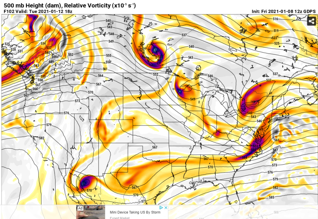
Despite the big picture looking decent the more individual vort maxes invloved the more precise everything has to come together. Coordinating 2 or 3 pieces of energy in a good pattern vs coordinating 5-6 pieces is exponentially more challenging. If just one is in a bad spot it induces the chain reaction to reshuffling the rest. And as we all know small changes at 500 have big implications on the surface. We shall see.
Regarding the 12th -13th potential. Todays 12z GFS gives you an idea of how complex it is. CONUS view:

#1 is our southern system. #2 ideally needs to dig into the back of it. However; #3 is diving into the NE from the north compliments of the -NAO block we have as 1 & 2 appraoch. The result is the inability for our system, #1, to raise heights out ahead of it on its own and suppression since #2 really isnt interacting until its too late.
Now look at our PNA region aka west coast. #4 is crashing the coast at just the wrong time. Result is flattening the northern component of our +PNA ridge. Result is the polar branch is flatter preventing #2 from digging into the back side of #1. If this happened it would combine energy, aka phase, which means stronger storm. Stronger storm = better chance to raise heights out ahead. Raised heights out ahead = storm comes north up the coast.
As if 5 pieces of energy wasnt enough to coordinate. Lets zoom out a bit. North America View:
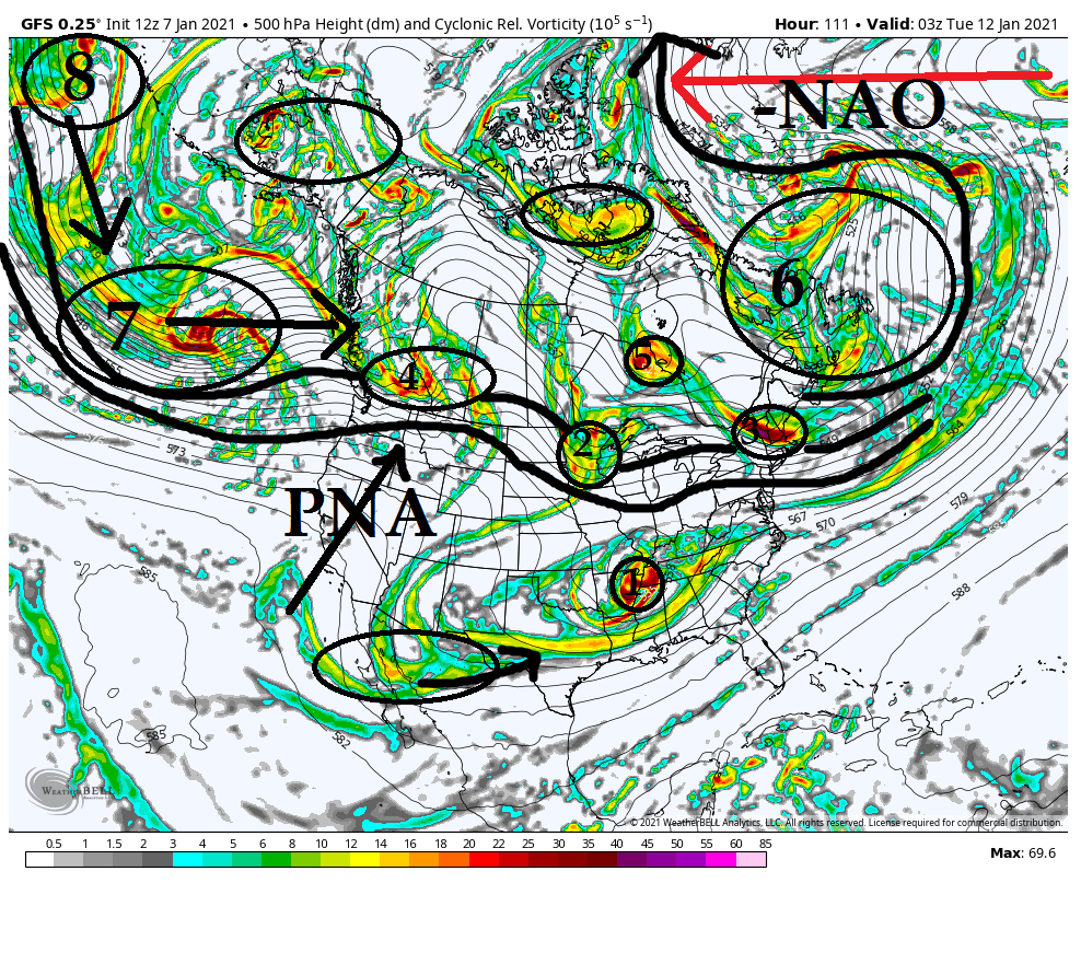
You can see the -NAO ridge is causing a major bottle neck of the energy (#6) in the N Atlantic. This is a good thing in general but Ive said it before sometimes too much of as good thing is a bad thing. In this case can lead to supressed strom tracks. ESP hen the Pac isnt cooperating which is the case in this image.
Look west. Wave after wave of energy is traversing the N Pac and crashing the west coast (8 to 7 to 4). The result is a PNA ridge that tries to amplify but consistently gets knowcked down. Timing has to be perfect with 1 and 2 as they approach the EC when you have such strong blocking in the NAO region otherwise the result is a flatened flow across the northern teir of the CONUS preventing N energy (ie: #2) from digging.
Now here is the thing. We often times get storms to come up when the NAO is relaxing. The reason is as it relaxes it allows our system to come up because it doesnt push so hard. We fortunately have the NAO forecast on both Euro and GFS ensembles to go from a -3 deviation to a -1 deviation. Will this be enough of a relaxation to our NE to allow our system to come north "enough" is yet to be determined.
Dont let the specific verbage from Ray confuse you. He is 100% correct in his idea that the chance isnt great given everything I'm showing above and just how many pieces of energy have to coordinate, BUT there is a chance. And its a decent chance IMHO. I believe models will correct as we get towards saturday or so showing a little more digging of #2 and perhaps a little more interaction between #1 and #2. I also think we see energy like #3 change in the modeling to be out of the way a little more. Again is it enough to make it work...odd favor against it at this time IMHO.
- on Thu Jan 07, 2021 1:33 pm
- Search in: Official Weather Talk Thread
- Topic: Long Range Discussion 20(20) (Ha!)
- Replies: 732
- Views: 31762
DECEMBER 16th 17th 2020 Snow Threat???
Frank_Wx wrote:My main focus is how Monday’s storm behaves. It will pretty much determine the outcome of Wednesday’s storm. We’re going to see models between today and Tuesday try to track the low over our area (meaning rain) and even out to sea. I will be shocked if the track doesn’t change at all between now and then.
Ah you went there. lol. This is my big anxiety right now. I love the projected track of this Wednesday storm and the timing with the cold air coming in courtesy of the High Pressure building in Canada, but I'm still nervous due to Monday's storm and the fact that we never really get a good grip on storm #2 until storm #1 plays out. So there is a part of me that will remain nervous until the Monday storm has run its course.
- on Sat Dec 12, 2020 10:33 am
- Search in: Official Weather Talk Thread
- Topic: DECEMBER 16th 17th 2020 Snow Threat???
- Replies: 589
- Views: 20756
Long Range Discussion 20(20) (Ha!)
Isotherm #1.- on Tue Nov 10, 2020 5:07 pm
- Search in: Official Weather Talk Thread
- Topic: Long Range Discussion 20(20) (Ha!)
- Replies: 732
- Views: 31762
Long Range Thread 19.0
GreyBeard wrote:A glimmer of hope perhaps.
http://www.msn.com/en-us/weather/topstories/could-a-big-storm-end-snow-drought-in-the-northeast-this-winter/ar-BB10DZg6?li=BBnbfcL&ocid=SK2HDHP
I would say barely a glimmer. The way things have been this year, I can for sure see scenario #1, snow to the north and south, nada here. Of course, the meet-up is Saturday, and we had to cancel the last one due to a weather event, what are the odds?
- on Mon Mar 02, 2020 9:38 pm
- Search in: Official Weather Talk Thread
- Topic: Long Range Thread 19.0
- Replies: 698
- Views: 26598
Long Range Thread 19.0
Frank_Wx wrote:Here is a look at the upper level pattern valid Friday afternoon. Very clearly you can see a piece of northern and southern stream upper air energy with a full-latitude western ridge. The +PNA greatly increases our chance for a coastal storm developing Sunday-Monday next week. The problem I'm seeing that could prevent said storm from developing is the pieces of upper air energy, or 500mb energy, never phase. There are reasons why that could be.
1. The southern energy is dug too far south and if a phase does happen the low pressure that develops will either be to our south or out to sea
2. The northern energy is too strong. This means it does not feel the influence of the western ridge and stays in southern Canada. No phase = no storm
3. The western ridge either collapses on future model runs or tries to propagate east too soon, basically disrupting the downstream pattern and pieces of energy from phasing.
4. Similar to #1, a phase does happen, however the coastal low that develops still never makes it up the coast because the blocking to our north is too strong. We would want the phase to happen near the Gulf coast or at that longitude somewhere, because if it happens east of there the block will shun the storm east.
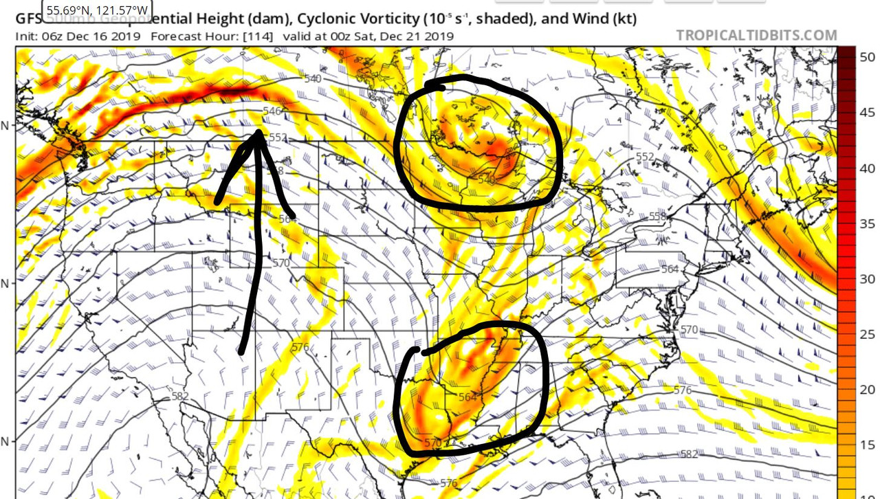
Either #1 or #2 are going to play out, and unfortunately, neither would mean a coastal storm hitting our area. Still some time for this one but odds greatly diminished. The Pacific upper level pattern not conducive for east coast snowstorms right now.
- on Tue Dec 17, 2019 9:31 am
- Search in: Official Weather Talk Thread
- Topic: Long Range Thread 19.0
- Replies: 698
- Views: 26598

Page 2 of 2 • 1, 2