
 Search
Current date/time is Fri May 10, 2024 12:32 am
Search found 1 match for 6
Long Range Discussion 20(20) (Ha!)
sroc4 wrote:
Despite the big picture looking decent the more individual vort maxes invloved the more precise everything has to come together. Coordinating 2 or 3 pieces of energy in a good pattern vs coordinating 5-6 pieces is exponentially more challenging. If just one is in a bad spot it induces the chain reaction to reshuffling the rest. And as we all know small changes at 500 have big implications on the surface. We shall see.
Regarding the 12th -13th potential. Todays 12z GFS gives you an idea of how complex it is. CONUS view:

#1 is our southern system. #2 ideally needs to dig into the back of it. However; #3 is diving into the NE from the north compliments of the -NAO block we have as 1 & 2 appraoch. The result is the inability for our system, #1, to raise heights out ahead of it on its own and suppression since #2 really isnt interacting until its too late.
Now look at our PNA region aka west coast. #4 is crashing the coast at just the wrong time. Result is flattening the northern component of our +PNA ridge. Result is the polar branch is flatter preventing #2 from digging into the back side of #1. If this happened it would combine energy, aka phase, which means stronger storm. Stronger storm = better chance to raise heights out ahead. Raised heights out ahead = storm comes north up the coast.
As if 5 pieces of energy wasnt enough to coordinate. Lets zoom out a bit. North America View:
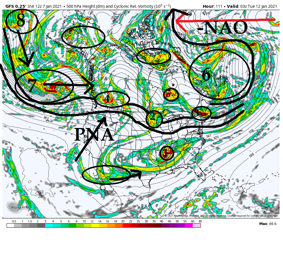
You can see the -NAO ridge is causing a major bottle neck of the energy (#6) in the N Atlantic. This is a good thing in general but Ive said it before sometimes too much of as good thing is a bad thing. In this case can lead to supressed strom tracks. ESP hen the Pac isnt cooperating which is the case in this image.
Look west. Wave after wave of energy is traversing the N Pac and crashing the west coast (8 to 7 to 4). The result is a PNA ridge that tries to amplify but consistently gets knowcked down. Timing has to be perfect with 1 and 2 as they approach the EC when you have such strong blocking in the NAO region otherwise the result is a flatened flow across the northern teir of the CONUS preventing N energy (ie: #2) from digging.
Now here is the thing. We often times get storms to come up when the NAO is relaxing. The reason is as it relaxes it allows our system to come up because it doesnt push so hard. We fortunately have the NAO forecast on both Euro and GFS ensembles to go from a -3 deviation to a -1 deviation. Will this be enough of a relaxation to our NE to allow our system to come north "enough" is yet to be determined.
Dont let the specific verbage from Ray confuse you. He is 100% correct in his idea that the chance isnt great given everything I'm showing above and just how many pieces of energy have to coordinate, BUT there is a chance. And its a decent chance IMHO. I believe models will correct as we get towards saturday or so showing a little more digging of #2 and perhaps a little more interaction between #1 and #2. I also think we see energy like #3 change in the modeling to be out of the way a little more. Again is it enough to make it work...odd favor against it at this time IMHO.
- on Thu Jan 07, 2021 1:33 pm
- Search in: Official Weather Talk Thread
- Topic: Long Range Discussion 20(20) (Ha!)
- Replies: 732
- Views: 31909
