January 2024 Observations and Discussion
Page 14 of 26 •  1 ... 8 ... 13, 14, 15 ... 20 ... 26
 Re: January 2024 Observations and Discussion
Irish wrote:sroc4 wrote:Irish wrote:sroc4 wrote:Irish wrote:Why is there no thread for Friday's storm?
Why do you need a seperate thread Irish? You may not be superstitious but there are many who are. It’s a discussion thread and an observation thread. I know it may sound silly to some but for many this next statement makes all the sense in the world. Please for the love of God and old man winter please don’t start a thread for this one.
Honestly, I think the exact opposite of you guys. I'm not superstitious at all. The weather and how it pans out is not reliant at all on whether or not this forum starts a separate storm thread. For me part of the build-up and excitement and thrill of the hunt (whether or not it comes to fruition) is the start of a separate, dedicated thread for a storm we're tracking.
I also feel that if we don't start a separate thread then it removes the intensity of the hunt and is basically delivering the message that the upcoming storm isn't significant and not worthy of our attention, even if that's not the case. Not having one takes the wind out of my sails a bit.
However, this is not my board and I'm not they only one to consider, especially when it comes to folks being superstitious, so the leaders here will do what they decide to do and I will follow and enjoy the best I can.
Sounds to me you’re just as superstitious as the rest of us loons. Lol. If you weren’t then who cares where we post about it?
Sounds valid. However, it's not being superstitious, it's being OCD a control freak. For me this is not the thread to discuss an individual storm, so it kinda irks me. But I'm managing through it just fine.
Potato, poe Ta toe. Lol. We’ve def discussed smaller storms in the observation thread before; esp during active years when there were plenty of big ones to track. I hear what your saying though. Just give me this one. If it turns out we all get crushed by 10” you’ll thank me and perhaps believe. Lol. If it’s a dud then no harm no foul and I’ll be the first to start a thread on the next one to track.
sroc4- Admin

- Posts : 8331
Join date : 2013-01-07
Grselig and Irish like this post
 Re: January 2024 Observations and Discussion
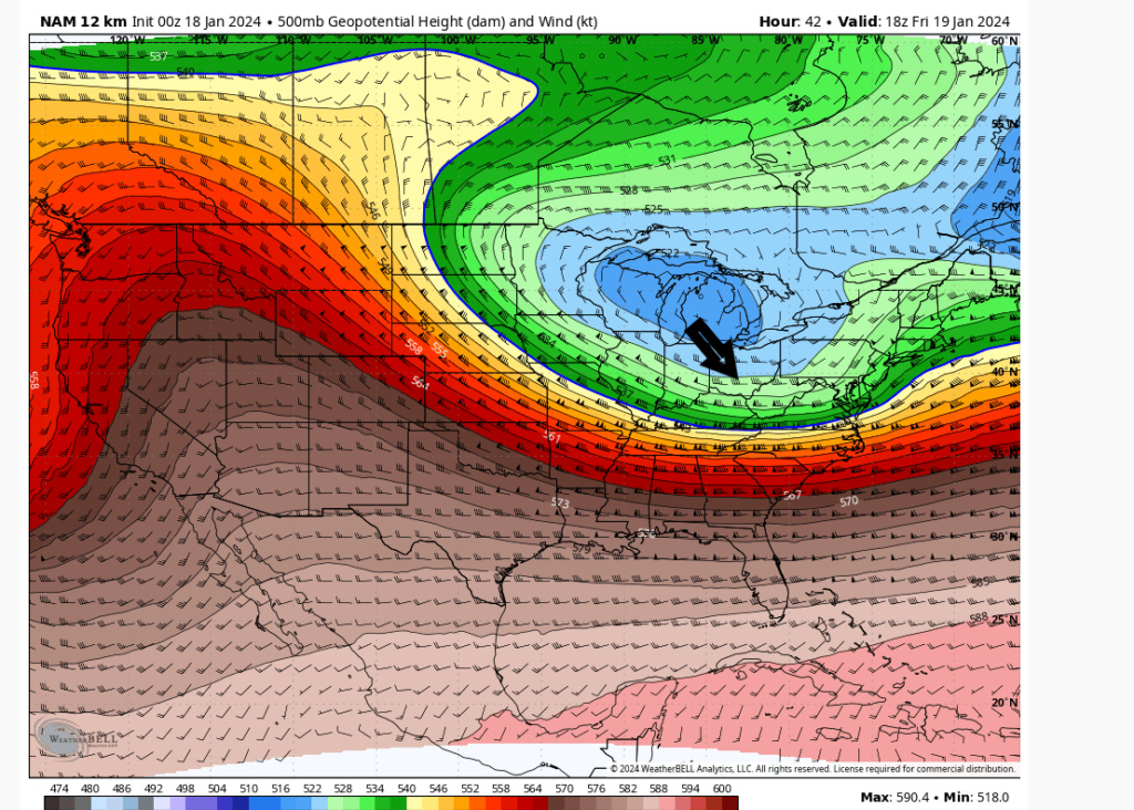
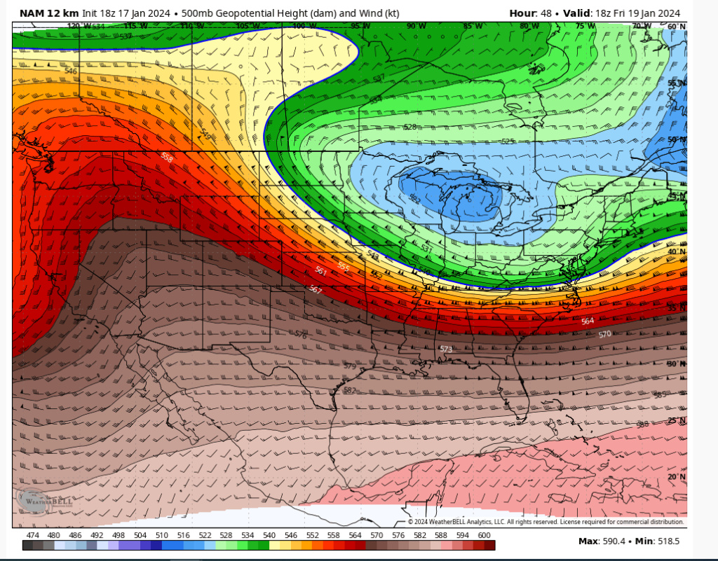
nutleyblizzard wrote:I assume that our departing storm was farther away from the trough as well allowing it to go negative?heehaw453 wrote:Sometimes the NAM can see this type of evolution before most models. But what struck me with this run is the trough was able to dig more and raise heights out ahead. that allowed it to capture the energy out ahead which exploded it as it hit the coast. interesting run.
I think it was better n/s interaction into the trough. So more juice was added to it best I can tell.
00Z

18Z

Last edited by heehaw453 on Wed Jan 17, 2024 10:07 pm; edited 1 time in total
heehaw453- Advanced Forecaster

- Posts : 3906
Join date : 2014-01-20
 Re: January 2024 Observations and Discussion
heehaw453 wrote:nutleyblizzard wrote:I assume that our departing storm was farther away from the trough as well allowing it to go negative?heehaw453 wrote:Sometimes the NAM can see this type of evolution before most models. But what struck me with this run is the trough was able to dig more and raise heights out ahead. that allowed it to capture the energy out ahead which exploded it as it hit the coast. interesting run.
I think it was better n/s interaction into the trough. So more juice was added to it best I can tell.
Heehaw. Using that same 500mb chart you have here toggle between 18z and 00z and stare at the pna ridge. It def is a tad further north with its heights. I’m sure that’s playing a role as to why it digs a tad better. It appears Rgem is doing the same
_________________
"In weather and in life, there's no winning and losing; there's only winning and learning."
WINTER 2012/2013 TOTALS 43.65"WINTER 2017/2018 TOTALS 62.85" WINTER 2022/2023 TOTALS 4.9"
WINTER 2013/2014 TOTALS 64.85"WINTER 2018/2019 TOTALS 14.25" WINTER 2023/2024 TOTALS 13.1"
WINTER 2014/2015 TOTALS 71.20"WINTER 2019/2020 TOTALS 6.35"
WINTER 2015/2016 TOTALS 35.00"WINTER 2020/2021 TOTALS 37.75"
WINTER 2016/2017 TOTALS 42.25"WINTER 2021/2022 TOTALS 31.65"

sroc4- Admin

- Posts : 8331
Reputation : 301
Join date : 2013-01-07
Location : Wading River, LI
 Re: January 2024 Observations and Discussion
heehaw453 wrote:nutleyblizzard wrote:I assume that our departing storm was farther away from the trough as well allowing it to go negative?heehaw453 wrote:Sometimes the NAM can see this type of evolution before most models. But what struck me with this run is the trough was able to dig more and raise heights out ahead. that allowed it to capture the energy out ahead which exploded it as it hit the coast. interesting run.
I think it was better n/s interaction into the trough. So more juice was added to it best I can tell.
Heehaw. Using that same 500mb chart you have here toggle between 18z and 00z and stare at the pna ridge. It def is a tad further north with its heights. I’m sure that’s playing a role as to why it digs a tad better. It appears Rgem is doing the same
_________________
"In weather and in life, there's no winning and losing; there's only winning and learning."
WINTER 2012/2013 TOTALS 43.65"WINTER 2017/2018 TOTALS 62.85" WINTER 2022/2023 TOTALS 4.9"
WINTER 2013/2014 TOTALS 64.85"WINTER 2018/2019 TOTALS 14.25" WINTER 2023/2024 TOTALS 13.1"
WINTER 2014/2015 TOTALS 71.20"WINTER 2019/2020 TOTALS 6.35"
WINTER 2015/2016 TOTALS 35.00"WINTER 2020/2021 TOTALS 37.75"
WINTER 2016/2017 TOTALS 42.25"WINTER 2021/2022 TOTALS 31.65"

sroc4- Admin

- Posts : 8331
Reputation : 301
Join date : 2013-01-07
Location : Wading River, LI
 Re: January 2024 Observations and Discussion
_________________
"In weather and in life, there's no winning and losing; there's only winning and learning."
WINTER 2012/2013 TOTALS 43.65"WINTER 2017/2018 TOTALS 62.85" WINTER 2022/2023 TOTALS 4.9"
WINTER 2013/2014 TOTALS 64.85"WINTER 2018/2019 TOTALS 14.25" WINTER 2023/2024 TOTALS 13.1"
WINTER 2014/2015 TOTALS 71.20"WINTER 2019/2020 TOTALS 6.35"
WINTER 2015/2016 TOTALS 35.00"WINTER 2020/2021 TOTALS 37.75"
WINTER 2016/2017 TOTALS 42.25"WINTER 2021/2022 TOTALS 31.65"

sroc4- Admin

- Posts : 8331
Reputation : 301
Join date : 2013-01-07
Location : Wading River, LI
heehaw453 and MattyICE like this post
 Re: January 2024 Observations and Discussion
sroc4 wrote:heehaw453 wrote:nutleyblizzard wrote:I assume that our departing storm was farther away from the trough as well allowing it to go negative?heehaw453 wrote:Sometimes the NAM can see this type of evolution before most models. But what struck me with this run is the trough was able to dig more and raise heights out ahead. that allowed it to capture the energy out ahead which exploded it as it hit the coast. interesting run.
I think it was better n/s interaction into the trough. So more juice was added to it best I can tell.
Heehaw. Using that same 500mb chart you have here toggle between 18z and 00z and stare at the pna ridge. It def is a tad further north with its heights. I’m sure that’s playing a role as to why it digs a tad better. It appears Rgem is doing the same
Yeah no doubt better ridging facilitated it. The N/S also has a lot juice close by with the TPV.
heehaw453- Advanced Forecaster

- Posts : 3906
Reputation : 86
Join date : 2014-01-20
Location : Bedminster Township, PA Elevation 600' ASL
sroc4 and MattyICE like this post
 Re: January 2024 Observations and Discussion
sroc4 wrote:And Rgem says you've all been nam'ed
Yep got to temper excitement. I say this to the NAM...
heehaw453- Advanced Forecaster

- Posts : 3906
Reputation : 86
Join date : 2014-01-20
Location : Bedminster Township, PA Elevation 600' ASL
sroc4 and MattyICE like this post
 Re: January 2024 Observations and Discussion
sroc4 wrote:And Rgem says you've all been nam'ed
RGEM is usually a good model. Doesn’t typically move away from the nam that much. Love the NAM/HRRR combo tonight, but that RGEM gives me cause to temper expectations a bit, at least through 18z tmw.
MattyICE- Advanced Forecaster

- Posts : 249
Reputation : 6
Join date : 2017-11-10
Age : 38
Location : Clifton, NJ (Eastern Passaic County)
 Re: January 2024 Observations and Discussion
_________________
_______________________________________________________________________________________________________
CLICK HERE to view NJ Strong Snowstorm Classifications
MattyICE likes this post
 Re: January 2024 Observations and Discussion
850 hPa (and even further below): Notably stronger f-gen/isentropic forcing likely induced by enhanced low-level vortex tube stretching and associated cyclonic vorticity/curvature thanks to an anomalous westerly wind component coming across the Appalachians. We aren’t dealing with a regular trough here; it’s actually a lobe of the Tropospheric PV, which is highly anomalous at this latitude, and therefore, modeling has been under-representative of the effects that this will have on the atmosphere.This also goes for all levels above this as well.
700 hPa: similar to the changes seen at the 850 hPa level.
250 hPa: Notably stronger jet streak with our area located in the left exit region, which allows enhanced forcing for ascent. This is directly a result of the enhanced f-gen in the lower levels. All of these enhanced forcing mechanisms align, which resulted in the higher output.
In my opinion, having only looked at this tonight, the enhanced solution would seem to fit the anomalousness of having a lobe of the tropospheric PV rotating overhead, and modeling being slow to pick up on that, and I would therefore not be surprised to see these trends continue across guidance over the next couple of runs.
Carry on.
rb924119- Meteorologist

- Posts : 6890
Reputation : 194
Join date : 2013-02-06
Age : 32
Location : Greentown, Pa
Frank_Wx, docstox12, aiannone, kalleg, Grselig, jmanley32, heehaw453 and like this post
 Re: January 2024 Observations and Discussion
rb924119 wrote:All this talk about H5 and the latest NAM run, but nothing is being mentioned about the rest of the atmosphere??? Come on, my fellow snow-starved weather nut family, we’re better than this!! lol to me, the changes at H5 seem to be relatively minor compared to previous runs, but it’s what’s happening everywhere else that made the difference. Let’s work from the lower levels, upward, starting at the 850 hPa level.
850 hPa (and even further below): Notably stronger f-gen/isentropic forcing likely induced by enhanced low-level vortex tube stretching and associated cyclonic vorticity/curvature thanks to an anomalous westerly wind component coming across the Appalachians. We aren’t dealing with a regular trough here; it’s actually a lobe of the Tropospheric PV, which is highly anomalous at this latitude, and therefore, modeling has been under-representative of the effects that this will have on the atmosphere.This also goes for all levels above this as well.
700 hPa: similar to the changes seen at the 850 hPa level.
250 hPa: Notably stronger jet streak with our area located in the left exit region, which allows enhanced forcing for ascent. This is directly a result of the enhanced f-gen in the lower levels. All of these enhanced forcing mechanisms align, which resulted in the higher output.
In my opinion, having only looked at this tonight, the enhanced solution would seem to fit the anomalousness of having a lobe of the tropospheric PV rotating overhead, and modeling being slow to pick up on that, and I would therefore not be surprised to see these trends continue across guidance over the next couple of runs.
Carry on.
It's nice to have a resident met keeping it real!
heehaw453- Advanced Forecaster

- Posts : 3906
Reputation : 86
Join date : 2014-01-20
Location : Bedminster Township, PA Elevation 600' ASL
rb924119 and Grselig like this post
heehaw453- Advanced Forecaster

- Posts : 3906
Reputation : 86
Join date : 2014-01-20
Location : Bedminster Township, PA Elevation 600' ASL
jmanley32 likes this post
 Re: January 2024 Observations and Discussion
_________________
_______________________________________________________________________________________________________
CLICK HERE to view NJ Strong Snowstorm Classifications
docstox12, aiannone, Dunnzoo, kalleg, rb924119, essexcountypete, jmanley32 and weatherwatchermom like this post
 Re: January 2024 Observations and Discussion
I shared your thoughts with other weather enthusiasts, see what they think...

Irish- Pro Enthusiast

- Posts : 788
Reputation : 19
Join date : 2019-01-16
Age : 45
Location : Old Bridge, NJ
rb924119 and MattyICE like this post
 Re: January 2024 Observations and Discussion
rb924119 wrote:All this talk about H5 and the latest NAM run, but nothing is being mentioned about the rest of the atmosphere??? Come on, my fellow snow-starved weather nut family, we’re better than this!! lol to me, the changes at H5 seem to be relatively minor compared to previous runs, but it’s what’s happening everywhere else that made the difference. Let’s work from the lower levels, upward, starting at the 850 hPa level.
850 hPa (and even further below): Notably stronger f-gen/isentropic forcing likely induced by enhanced low-level vortex tube stretching and associated cyclonic vorticity/curvature thanks to an anomalous westerly wind component coming across the Appalachians. We aren’t dealing with a regular trough here; it’s actually a lobe of the Tropospheric PV, which is highly anomalous at this latitude, and therefore, modeling has been under-representative of the effects that this will have on the atmosphere.This also goes for all levels above this as well.
700 hPa: similar to the changes seen at the 850 hPa level.
250 hPa: Notably stronger jet streak with our area located in the left exit region, which allows enhanced forcing for ascent. This is directly a result of the enhanced f-gen in the lower levels. All of these enhanced forcing mechanisms align, which resulted in the higher output.
In my opinion, having only looked at this tonight, the enhanced solution would seem to fit the anomalousness of having a lobe of the tropospheric PV rotating overhead, and modeling being slow to pick up on that, and I would therefore not be surprised to see these trends continue across guidance over the next couple of runs.
Carry on.
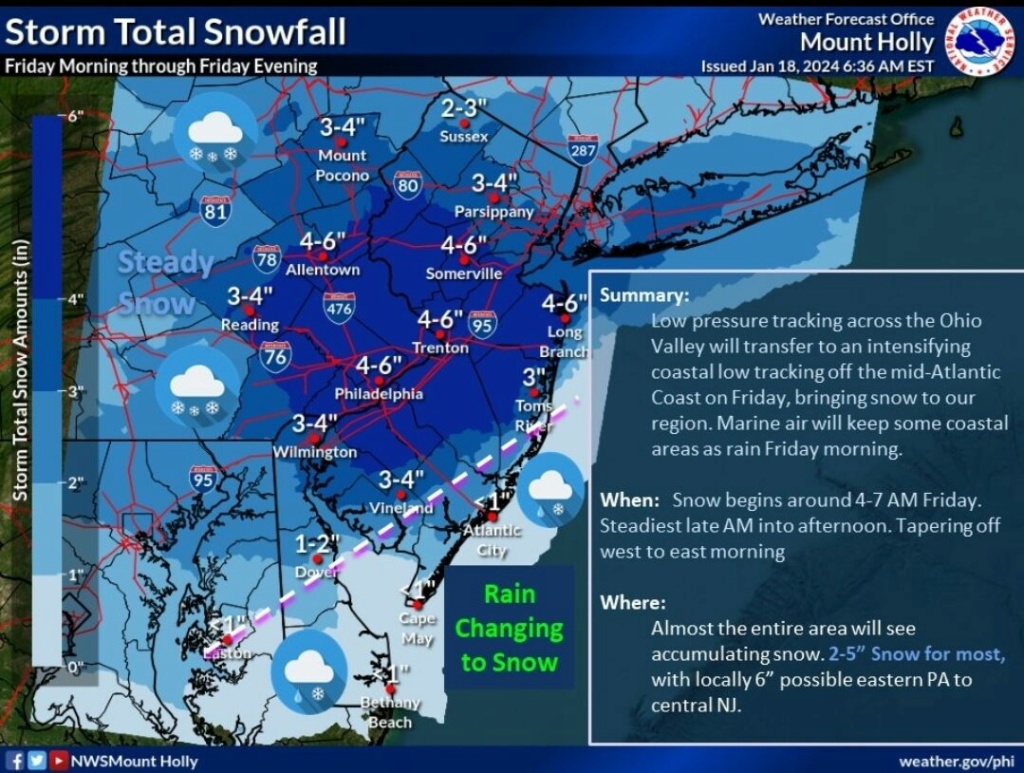
Hemispherically, there looks to be strong support that the axis of the IVT feature should be centered further south than what the NAM/SREF/HRRR cluster have, closer to the latitude of Philadelphia. HOWEVER, this isn’t really a standard IVT setup in that you have a very broad area of synoptically forced ascent. So, while the centerline may be that far south, a large portion of our area would likely still see the higher totals because of the broadness of the zone of forcing for ascent. Basically, I think it could be a horizontal band of snow that sets up from about Baltimore to I-84 that then slips eastward, rather than a band that’s extremely narrow.
rb924119- Meteorologist

- Posts : 6890
Reputation : 194
Join date : 2013-02-06
Age : 32
Location : Greentown, Pa
kalleg, jmanley32 and MattyICE like this post
 Re: January 2024 Observations and Discussion
Definitely glad I brought some of us back off the ledge a little bit Frank haha
And thanks, Irish!
Just offering some quick thoughts on this while I have the time haha
rb924119- Meteorologist

- Posts : 6890
Reputation : 194
Join date : 2013-02-06
Age : 32
Location : Greentown, Pa
jmanley32 and silentwreck like this post
 Re: January 2024 Observations and Discussion

hyde345- Pro Enthusiast

- Posts : 1082
Reputation : 48
Join date : 2013-01-08
Location : Hyde Park, NY
 Re: January 2024 Observations and Discussion
Wow if verified at 15:1 this would be warning level snows for many. Not counting on it need to see more consistency but rb's analysis was really good and makes a good point and hopefully we do see trends for the better.

jmanley32- Senior Enthusiast

- Posts : 20517
Reputation : 108
Join date : 2013-12-12
Age : 42
Location : Yonkers, NY
 Re: January 2024 Observations and Discussion
I cannot picture that does that place NYC in that band or are we north of it? Not too familiar with NJ highways. Edit NVW I see now so ya NYC would be in fair game and even southern NY.rb924119 wrote:rb924119 wrote:All this talk about H5 and the latest NAM run, but nothing is being mentioned about the rest of the atmosphere??? Come on, my fellow snow-starved weather nut family, we’re better than this!! lol to me, the changes at H5 seem to be relatively minor compared to previous runs, but it’s what’s happening everywhere else that made the difference. Let’s work from the lower levels, upward, starting at the 850 hPa level.
850 hPa (and even further below): Notably stronger f-gen/isentropic forcing likely induced by enhanced low-level vortex tube stretching and associated cyclonic vorticity/curvature thanks to an anomalous westerly wind component coming across the Appalachians. We aren’t dealing with a regular trough here; it’s actually a lobe of the Tropospheric PV, which is highly anomalous at this latitude, and therefore, modeling has been under-representative of the effects that this will have on the atmosphere.This also goes for all levels above this as well.
700 hPa: similar to the changes seen at the 850 hPa level.
250 hPa: Notably stronger jet streak with our area located in the left exit region, which allows enhanced forcing for ascent. This is directly a result of the enhanced f-gen in the lower levels. All of these enhanced forcing mechanisms align, which resulted in the higher output.
In my opinion, having only looked at this tonight, the enhanced solution would seem to fit the anomalousness of having a lobe of the tropospheric PV rotating overhead, and modeling being slow to pick up on that, and I would therefore not be surprised to see these trends continue across guidance over the next couple of runs.
Carry on.
Hemispherically, there looks to be strong support that the axis of the IVT feature should be centered further south than what the NAM/SREF/HRRR cluster have, closer to the latitude of Philadelphia. HOWEVER, this isn’t really a standard IVT setup in that you have a very broad area of synoptically forced ascent. So, while the centerline may be that far south, a large portion of our area would likely still see the higher totals because of the broadness of the zone of forcing for ascent. Basically, I think it could be a horizontal band of snow that sets up from about Baltimore to I-84 that then slips eastward, rather than a band that’s extremely narrow.

jmanley32- Senior Enthusiast

- Posts : 20517
Reputation : 108
Join date : 2013-12-12
Age : 42
Location : Yonkers, NY
 Re: January 2024 Observations and Discussion
rb924119- Meteorologist

- Posts : 6890
Reputation : 194
Join date : 2013-02-06
Age : 32
Location : Greentown, Pa
jmanley32 likes this post
 Re: January 2024 Observations and Discussion
Headed east, trying to picture how ur saying it would move, thats not a band lol thats a huge area, and looking where I-84 is (duh) its well north of me putting me in the northern half of your call area. Here is hoping. Still doubting it especially since we have no WWA.rb924119 wrote:Basically the entire length of NJ, Jman, from Cape May to the tip of Sussex lol

jmanley32- Senior Enthusiast

- Posts : 20517
Reputation : 108
Join date : 2013-12-12
Age : 42
Location : Yonkers, NY
 Re: January 2024 Observations and Discussion
Frank_Wx wrote:Ray just saved 40% of us from jumping a bridge
LOL! Right up there with John Belushi in Animal House..."It's not over until we say it over!"
This part right here almost had me out of my seat... "Notably stronger f-gen/isentropic forcing likely induced by enhanced low-level vortex tube stretching and associated cyclonic vorticity/curvature thanks to an anomalous westerly wind component..." I'm like "YEAH! I don't know what this means but...YEAH!!!!!"

essexcountypete- Pro Enthusiast

- Posts : 783
Reputation : 12
Join date : 2013-12-09
Location : Bloomfield, NJ
kalleg likes this post
 Re: January 2024 Observations and Discussion
2022-23: -13* (2/4/23)
2021-22: -6* (1/22/22)
2020-21: -7* (1/31/21)
2019-20: +1* (12/8/19)
2018-19: -8* (2/1/19)
2017-18: -10* (1/1/18)
2016-17: +1* (12/16/16)
2015-16: -13* (2/14/16)
2014-15: -12* (2/3/15)
2013-14: -12* (1/4/14)
2012-13: -5* (1/3/13 & 2/10/13)
2011-12: 0* (1/15/12 & 1/22/12)
2010-11: -13* (1/24/11)
2009-10: -2* (1/30/10)
2008-09: -8* (1/16/09)
2007-08: -5* (1/3/08)
2006-07: -3* (1/26/07, 3/6/07 & 3/9/07)
2005-06: +1* (12/14/05)
2004-05: -16* (1/28/05)
2003-04: -13* (1/14/04)
2002-03: -12* (1/28/03)
2001-02: +1* (1/8/02)
This is as far back as I decided to go. This weekend, it'll be unseasonable cold for sure, but nothing compared to the cold weather on the dates I have provided.
Math23x7- Wx Statistician Guru

- Posts : 2379
Reputation : 68
Join date : 2013-01-08
kalleg likes this post

1190ftalt- Pro Enthusiast

- Posts : 397
Reputation : 10
Join date : 2013-12-13
Location : Stillwater, NJ
 Re: January 2024 Observations and Discussion
_________________
_______________________________________________________________________________________________________
CLICK HERE to view NJ Strong Snowstorm Classifications
1190ftalt likes this post
 Re: January 2024 Observations and Discussion

jmanley32- Senior Enthusiast

- Posts : 20517
Reputation : 108
Join date : 2013-12-12
Age : 42
Location : Yonkers, NY

skinsfan1177- Senior Enthusiast

- Posts : 4485
Reputation : 35
Join date : 2013-01-07
Age : 46
Location : Point Pleasant Boro
1190ftalt and weatherwatchermom like this post
Page 14 of 26 •  1 ... 8 ... 13, 14, 15 ... 20 ... 26
|
|
|

 Home
Home


