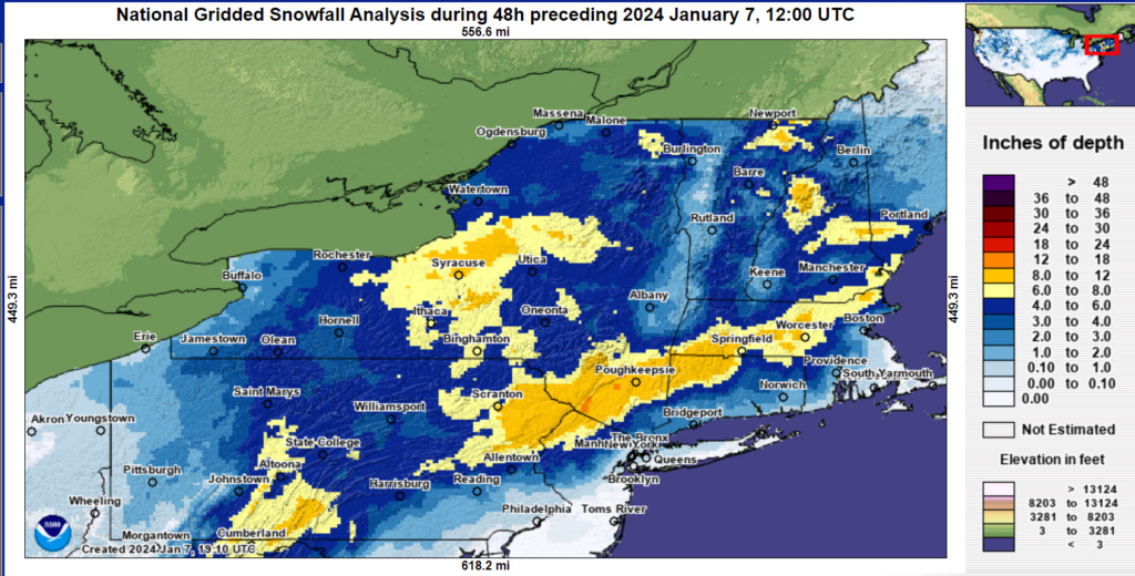
JAN 6th-7th Storm Part II
+44
sroc4
dfig529
sabamfa
lglickman1
JoeBx82
Artechmetals
algae888
weatherwatchermom
silentwreck
Aerojet514
nancy-j-s
emokid51783
brownie
DAYBLAZER
Brookster
Dunnzoo
1190ftalt
essexcountypete
toople
oldtimer
JT33
GreyBeard
CPcantmeasuresnow
2004blackwrx
frank 638
nutleyblizzard
Coachgriff
dkodgis
phil155
Irish
MattyICE
docstox12
dsix85
Koroptim
billg315
jmanley32
heehaw453
rb924119
hyde345
amugs
crippo84
Frozen.9
aiannone
Frank_Wx
48 posters
Page 26 of 26
Page 26 of 26 •  1 ... 14 ... 24, 25, 26
 Re: JAN 6th-7th Storm Part II
It’s over snow stop sun is trying to come out
frank 638- Senior Enthusiast

- Posts : 2824
Join date : 2016-01-01
 Re: JAN 6th-7th Storm Part II
4.25 total from storm. 34* this morning cut down greatly on accumulations drom the 3 hours of heavy to moderate wrap around snows.
amugs- Advanced Forecaster - Mod

- Posts : 15093
Join date : 2013-01-07
heehaw453 likes this post
 Re: JAN 6th-7th Storm Part II
Ended up with 9.3 inches here. I couldn't quite make the double digits so many just 10-15 miles north and west of me enjoyed.
Still a nice storm, I'll enjoy it for a few days until the dreaded GLC. Definitely three more letters I have to ban from OOTI in addition to the already banned letters of MJO..
Still a nice storm, I'll enjoy it for a few days until the dreaded GLC. Definitely three more letters I have to ban from OOTI in addition to the already banned letters of MJO..

CPcantmeasuresnow- Wx Statistician Guru

- Posts : 7274
Reputation : 230
Join date : 2013-01-07
Age : 103
Location : Eastern Orange County, NY
Frank_Wx, docstox12 and jmanley32 like this post
 Re: JAN 6th-7th Storm Part II
This link is cool. Search "new york" in the location bar and then use the zoom functionality to check out local snow reports
https://www.weather.gov/source/crh/snowmap.html?zoom=7&lat=34.21&lon=-95.69&hr=48
https://www.weather.gov/source/crh/snowmap.html?zoom=7&lat=34.21&lon=-95.69&hr=48
_________________
_______________________________________________________________________________________________________
CLICK HERE to view NJ Strong Snowstorm Classifications
 Re: JAN 6th-7th Storm Part II
_________________
_______________________________________________________________________________________________________
CLICK HERE to view NJ Strong Snowstorm Classifications
1190ftalt likes this post
 Re: JAN 6th-7th Storm Part II
I measured here this morning and we had 11”. Absolutely PHENOMENAL snowfall forecast, Frank!
Not sure what 1190ft got for snow moisture content, but ours was absolute powder last night. The couple inches we got this morning were definitely wetter, though, as expected. We did get a slight crust between the two snows from freezing drizzle that occurred after that main warm advection moved through, but before the wrap-around CCB.
My 11-17 approximation wasn’t terrible, but I took a beating everywhere else. In summary, I think my ideas on where the lower-level circulation would wind up were good. But again, the expected response was not. And the more that I sit back now that it’s over and think about it, there were definitely signs that I didn’t consider, and lessons that I can take away from this and (hopefully) remember. The most important one, I think, is that even though we had an overall favorable evolution at the 850 hPa level and below (toward the surface, i.e. the boundary layer), we were still working with a net southerly/southwesterly flow above that. It’s near impossible to snow on a south wind away from any elevations, and even there usually you still taint anyway. I’ve seen that movie too many times before, but apparently, I didn’t learn my lesson yet.
Another factor, and this is to heehaw’s earlier point, and it links in with the above, was the strength of the trough out west (-PNA). I thought that given all of the other factors, its resistance to troughing over the eastern CONUS would be overwhelmed. The problem with that, though, is that it can only be overwhelmed to a point. We DID get the eastward shift; our storm was originally a GLC, and the boundary layer circulations did respond as I thought. The problem, though, was the mid-level circulations (H7 and H5), which both tracked to our northwest.
A third factor that ties in with my first two points, was that the above mid-level circulations were not strong or intensifying. This allowed the general flow to remain southwesterly thanks to the resistance from the western trough (-PNA), and we just had the boundary circulations embedded within it. So even though they tracked to our southeast, it really wasn’t a great setup, to Frank’s credit.
To my final point, I just want to thank you all for the support and acceptance of my apology last night for my poor performance with this event. It definitely means a lot to me. But I want you to know that I don’t take it lightly - yeah the discussion is fun, and when it comes to snow and even big, impactful storms, it’s exciting. But those of us who forecast also take on an inherent responsibility to provide you with the best and most accurate information that we can, because there are lives and property that are directly affected by what we say, and the actions that are taken in response to that. So when I get something wrong, yeah, I’m hard on myself, because there’s a lot of responsibility to account for. Plus, and a little more lightheartedly, I don’t like losing lmao but yeah, I definitely appreciate your understanding, and I wanted to make that clear. I’ll definitely try to do better for you all next time!
rb924119- Meteorologist

- Posts : 6890
Reputation : 194
Join date : 2013-02-06
Age : 32
Location : Greentown, Pa
Frank_Wx and 1190ftalt like this post
 Re: JAN 6th-7th Storm Part II
As I said to you last night weather is not a exact science, you got parts right and some not so right, but in part overall it did happen the way you could best forecast it. Curious if you can post your ideas on how bad the midweek cutter will be, dunno if you looked into it at all. Theres another thread for that. As for snowstorms onto the next whcih sounds like it could possibly be Sat? I wonder how many meterologists feel the way you do, of course we don't hear their take on themselves like we do from you. I would not say you need to apologize for anything.rb924119 wrote:
I measured here this morning and we had 11”. Absolutely PHENOMENAL snowfall forecast, Frank!
Not sure what 1190ft got for snow moisture content, but ours was absolute powder last night. The couple inches we got this morning were definitely wetter, though, as expected. We did get a slight crust between the two snows from freezing drizzle that occurred after that main warm advection moved through, but before the wrap-around CCB.
My 11-17 approximation wasn’t terrible, but I took a beating everywhere else. In summary, I think my ideas on where the lower-level circulation would wind up were good. But again, the expected response was not. And the more that I sit back now that it’s over and think about it, there were definitely signs that I didn’t consider, and lessons that I can take away from this and (hopefully) remember. The most important one, I think, is that even though we had an overall favorable evolution at the 850 hPa level and below (toward the surface, i.e. the boundary layer), we were still working with a net southerly/southwesterly flow above that. It’s near impossible to snow on a south wind away from any elevations, and even there usually you still taint anyway. I’ve seen that movie too many times before, but apparently, I didn’t learn my lesson yet.
Another factor, and this is to heehaw’s earlier point, and it links in with the above, was the strength of the trough out west (-PNA). I thought that given all of the other factors, its resistance to troughing over the eastern CONUS would be overwhelmed. The problem with that, though, is that it can only be overwhelmed to a point. We DID get the eastward shift; our storm was originally a GLC, and the boundary layer circulations did respond as I thought. The problem, though, was the mid-level circulations (H7 and H5), which both tracked to our northwest.
A third factor that ties in with my first two points, was that the above mid-level circulations were not strong or intensifying. This allowed the general flow to remain southwesterly thanks to the resistance from the western trough (-PNA), and we just had the boundary circulations embedded within it. So even though they tracked to our southeast, it really wasn’t a great setup, to Frank’s credit.
To my final point, I just want to thank you all for the support and acceptance of my apology last night for my poor performance with this event. It definitely means a lot to me. But I want you to know that I don’t take it lightly - yeah the discussion is fun, and when it comes to snow and even big, impactful storms, it’s exciting. But those of us who forecast also take on an inherent responsibility to provide you with the best and most accurate information that we can, because there are lives and property that are directly affected by what we say, and the actions that are taken in response to that. So when I get something wrong, yeah, I’m hard on myself, because there’s a lot of responsibility to account for. Plus, and a little more lightheartedly, I don’t like losing lmao but yeah, I definitely appreciate your understanding, and I wanted to make that clear. I’ll definitely try to do better for you all next time!

jmanley32- Senior Enthusiast

- Posts : 20516
Reputation : 108
Join date : 2013-12-12
Age : 42
Location : Yonkers, NY
 Re: JAN 6th-7th Storm Part II
rb924119 wrote:
I measured here this morning and we had 11”. Absolutely PHENOMENAL snowfall forecast, Frank!
Not sure what 1190ft got for snow moisture content, but ours was absolute powder last night. The couple inches we got this morning were definitely wetter, though, as expected. We did get a slight crust between the two snows from freezing drizzle that occurred after that main warm advection moved through, but before the wrap-around CCB.
My 11-17 approximation wasn’t terrible, but I took a beating everywhere else. In summary, I think my ideas on where the lower-level circulation would wind up were good. But again, the expected response was not. And the more that I sit back now that it’s over and think about it, there were definitely signs that I didn’t consider, and lessons that I can take away from this and (hopefully) remember. The most important one, I think, is that even though we had an overall favorable evolution at the 850 hPa level and below (toward the surface, i.e. the boundary layer), we were still working with a net southerly/southwesterly flow above that. It’s near impossible to snow on a south wind away from any elevations, and even there usually you still taint anyway. I’ve seen that movie too many times before, but apparently, I didn’t learn my lesson yet.
Another factor, and this is to heehaw’s earlier point, and it links in with the above, was the strength of the trough out west (-PNA). I thought that given all of the other factors, its resistance to troughing over the eastern CONUS would be overwhelmed. The problem with that, though, is that it can only be overwhelmed to a point. We DID get the eastward shift; our storm was originally a GLC, and the boundary layer circulations did respond as I thought. The problem, though, was the mid-level circulations (H7 and H5), which both tracked to our northwest.
A third factor that ties in with my first two points, was that the above mid-level circulations were not strong or intensifying. This allowed the general flow to remain southwesterly thanks to the resistance from the western trough (-PNA), and we just had the boundary circulations embedded within it. So even though they tracked to our southeast, it really wasn’t a great setup, to Frank’s credit.
To my final point, I just want to thank you all for the support and acceptance of my apology last night for my poor performance with this event. It definitely means a lot to me. But I want you to know that I don’t take it lightly - yeah the discussion is fun, and when it comes to snow and even big, impactful storms, it’s exciting. But those of us who forecast also take on an inherent responsibility to provide you with the best and most accurate information that we can, because there are lives and property that are directly affected by what we say, and the actions that are taken in response to that. So when I get something wrong, yeah, I’m hard on myself, because there’s a lot of responsibility to account for. Plus, and a little more lightheartedly, I don’t like losing lmao but yeah, I definitely appreciate your understanding, and I wanted to make that clear. I’ll definitely try to do better for you all next time!
Hey rb, great job on all the analysis. The way some of the totals added up, it was such a difficult forecast. I will say, the snow here in my neck of the woods was wet, perfect for making snowballs and snowmen. If you have time (lol) would you be able to go back and do the math again to determine where the wet snow/dry snow ends up? I think it would be quite interesting. Thanks again for all your hard work!
_________________
Janet
Snowfall winter of 2023-2024 17.5"
Snowfall winter of 2022-2023 6.0"
Snowfall winter of 2021-2022 17.6" 1" sleet 2/25/22
Snowfall winter of 2020-2021 51.1"
Snowfall winter of 2019-2020 8.5"
Snowfall winter of 2018-2019 25.1"
Snowfall winter of 2017-2018 51.9"
Snowfall winter of 2016-2017 45.6"
Snowfall winter of 2015-2016 29.5"
Snowfall winter of 2014-2015 50.55"
Snowfall winter of 2013-2014 66.5"
Dunnzoo- Senior Enthusiast - Mod

- Posts : 4891
Reputation : 68
Join date : 2013-01-11
Age : 62
Location : Westwood, NJ
1190ftalt likes this post
 Re: JAN 6th-7th Storm Part II
Nice little storm. Picked up 12 inches, about 6 of that in about 2 hours last night.

hyde345- Pro Enthusiast

- Posts : 1082
Reputation : 48
Join date : 2013-01-08
Location : Hyde Park, NY
Frank_Wx, docstox12, jmanley32 and 1190ftalt like this post
 Re: JAN 6th-7th Storm Part II
Between 12-3 am, it rocked

dkodgis- Senior Enthusiast

- Posts : 2501
Reputation : 98
Join date : 2013-12-29
 Re: JAN 6th-7th Storm Part II
Final total here in Monroe NY was 10.5 inches.

docstox12- Wx Statistician Guru

- Posts : 8504
Reputation : 222
Join date : 2013-01-07
Age : 73
Location : Monroe NY
Dunnzoo likes this post
 Re: JAN 6th-7th Storm Part II
6.5" for me here in Albany, NY
Math23x7- Wx Statistician Guru

- Posts : 2379
Reputation : 68
Join date : 2013-01-08
Frank_Wx likes this post
 Re: JAN 6th-7th Storm Part II
Hello Mike!!
_________________
_______________________________________________________________________________________________________
CLICK HERE to view NJ Strong Snowstorm Classifications
 Re: JAN 6th-7th Storm Part II
Elizabeth Taylor once said "Success is a sweet deodorant".
Let me say: "Snow in winter is a sweet deodorant" for the faithful
Let me say: "Snow in winter is a sweet deodorant" for the faithful

dkodgis- Senior Enthusiast

- Posts : 2501
Reputation : 98
Join date : 2013-12-29
Page 26 of 26 •  1 ... 14 ... 24, 25, 26
Page 26 of 26
Permissions in this forum:
You cannot reply to topics in this forum|
|
|

 Home
Home
