
 Search
Feb 9th-10th Storm Final Discussion/Observations
Page 7 of 15 •  1 ... 6, 7, 8 ... 11 ... 15
 ![]()
Re: Feb 9th-10th Storm Final Discussion/Observations
![]() by SoulSingMG Thu Feb 06, 2014 3:58 pm
by SoulSingMG Thu Feb 06, 2014 3:58 pm
SoulSingMG- Senior Enthusiast

- Posts : 2853
Join date : 2013-12-11
Re: Feb 9th-10th Storm Final Discussion/Observations
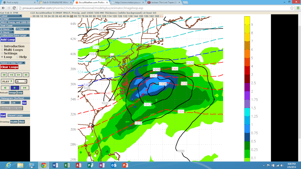
![]() by NjWeatherGuy Thu Feb 06, 2014 4:08 pm
by NjWeatherGuy Thu Feb 06, 2014 4:08 pm
12z
http://www.meteo.psu.edu/~fxg1/ETAPA_12z/etaloop.html
18z
http://www.meteo.psu.edu/~fxg1/ETAPA_18z/etaloop.html
Supporting my idea of "creeping" towards a better solution.
NjWeatherGuy- Advanced Forecaster

- Posts : 4100
Join date : 2013-01-06
Re: Feb 9th-10th Storm Final Discussion/Observations
![]() by NjWeatherGuy Thu Feb 06, 2014 4:10 pm
by NjWeatherGuy Thu Feb 06, 2014 4:10 pm
WOLVES1 wrote: Does anyone know what the euro looked like?
12z EURO (southern storm)
12z EURO (clipper (northern storm))

A couple frames of snow like this, verbatim 1-3"

NjWeatherGuy- Advanced Forecaster
- Posts : 4100
Reputation : 28
Join date : 2013-01-06
Location : Belle Mead, NJ

WOLVES1- Posts : 103
Reputation : 0
Join date : 2013-01-10
Age : 53
Location : Malverne NY
Re: Feb 9th-10th Storm Final Discussion/Observations
![]() by SoulSingMG Thu Feb 06, 2014 4:28 pm
by SoulSingMG Thu Feb 06, 2014 4:28 pm

SoulSingMG- Senior Enthusiast
- Posts : 2853
Reputation : 74
Join date : 2013-12-11
Location : Long Island City, NY
Re: Feb 9th-10th Storm Final Discussion/Observations
![]() by aiannone Thu Feb 06, 2014 5:05 pm
by aiannone Thu Feb 06, 2014 5:05 pm
_________________
-Alex Iannone-

aiannone- Senior Enthusiast - Mod

- Posts : 4819
Reputation : 92
Join date : 2013-01-07
Location : Saint James, LI (Northwest Suffolk Co.)
Re: Feb 9th-10th Storm Final Discussion/Observations
![]() by algae888 Thu Feb 06, 2014 5:14 pm
by algae888 Thu Feb 06, 2014 5:14 pm
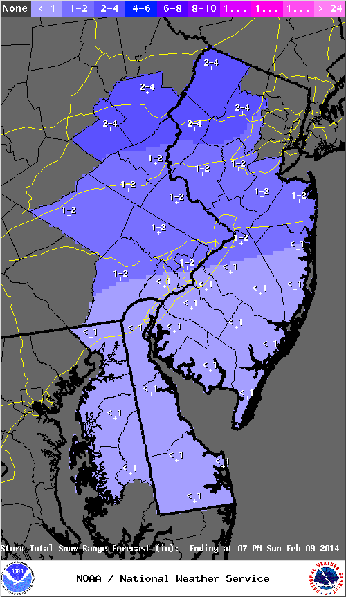
EXPECTED TO AFFECT THE AREA FROM THE WEST. THE GFS/NAM/SREF/CANADIAN
INDICATE MORE PRECIPITATION WITH THIS DISTURBANCE, WHILE THE
ECMWF/UKMET PRODUCE LESS. WE WILL KEEP A CHANCE OF PRECIPITATION
ASSOCIATED WITH THIS DISTURBANCE OVERNIGHT SATURDAY INTO SUNDAY
NIGHT. THE NORTHERN HALF OF THE AREA LOOKS TO BE AFFECTED THE MOST
BY THIS DISTURBANCE. THIS IS THE TIME PERIOD WHERE WE WOULD EXPECT
BETTER CHANCE OF SNOW ACCUMULATIONS ACROSS THE AREA, ALTHOUGH WE ARE
NOT EXPECTING AS MUCH AS WE`VE HAD WITH THE PAST FEW STORMS. WE ARE
GENERALLY EXPECTING AROUND 2-4 INCHES ACROSS OUR NORTHERN TIER
COUNTIES, WITH 1-2 POSSIBLE FOR OUR CENTRAL TIER, AND AROUND IN INCH
OR LESS FOR OUR SOUTHERN HALF.
this seems to be the NS s/w

algae888- Advanced Forecaster
- Posts : 5311
Reputation : 46
Join date : 2013-02-05
Age : 62
Location : mt. vernon, new york
Re: Feb 9th-10th Storm Final Discussion/Observations
![]() by docstox12 Thu Feb 06, 2014 5:15 pm
by docstox12 Thu Feb 06, 2014 5:15 pm
Mets2695 wrote:Mt. Holly totals for Sunday
I'll take that 2 to 4.Should be easy to shovel.

docstox12- Wx Statistician Guru

- Posts : 8561
Reputation : 222
Join date : 2013-01-07
Age : 73
Location : Monroe NY
Re: Feb 9th-10th Storm Final Discussion/Observations
![]() by RJB8525 Thu Feb 06, 2014 5:39 pm
by RJB8525 Thu Feb 06, 2014 5:39 pm
PUBLIC INFORMATION STATEMENT
NATIONAL WEATHER SERVICE NEW YORK NY
535 PM EST WED FEB 05 2014
...POTENTIAL FOR A CHANCE OF SNOW THIS WEEKEND...
ALTHOUGH FORECAST MODELS SHOW A CHANCE FOR A PERIOD OF SNOW THIS
WEEKEND...THEY DO NOT SHOW THE POTENTIAL FOR A LARGE COASTAL STORM
THAT WOULD BRING HIGH IMPACTS ACROSS THE REGION.
YOUR NATIONAL WEATHER SERVICE IS FORECASTING A ...CHANCE... OF SNOW
FROM SATURDAY AFTERNOON THROUGH EARLY MONDAY.
WE WILL CONTINUE TO MONITOR THE DEVELOPMENT OF A LOW PRESSURE SYSTEM
OFF THE SOUTHEAST COAST ON SATURDAY WITH AN APPROACHING UPPER LEVEL
TROUGH OF LOW PRESSURE ON SUNDAY.
STAY TUNED TO YOUR LATEST NATIONAL WEATHER SERVICE FORECASTS AT:

RJB8525- Senior Enthusiast
- Posts : 1994
Reputation : 28
Join date : 2013-02-06
Age : 38
Location : Hackettstown, NJ
Re: Feb 9th-10th Storm Final Discussion/Observations
![]() by skinsfan1177 Thu Feb 06, 2014 5:43 pm
by skinsfan1177 Thu Feb 06, 2014 5:43 pm

skinsfan1177- Senior Enthusiast
- Posts : 4485
Reputation : 35
Join date : 2013-01-07
Age : 46
Location : Point Pleasant Boro
Re: Feb 9th-10th Storm Final Discussion/Observations
![]() by Taffy Thu Feb 06, 2014 6:33 pm
by Taffy Thu Feb 06, 2014 6:33 pm

Taffy- Pro Enthusiast

- Posts : 530
Reputation : 19
Join date : 2013-10-06
Location : Hopkinton, MA
Re: Feb 9th-10th Storm Final Discussion/Observations
![]() by Dunnzoo Thu Feb 06, 2014 6:39 pm
by Dunnzoo Thu Feb 06, 2014 6:39 pm
Taffy wrote:I'm looking for a good primer on meteorology. I'm trying to teach myself some of the basics and I've found most websites assume you have a basic knowledge. As my daughters say, You love weather and weather events". I would like to follow along better than I do now. Any suggestions are appreciated.
Taffy, try this for starters....
http://theweatherwiz.com/school.htm
_________________
Janet
Snowfall winter of 2023-2024 17.5"
Snowfall winter of 2022-2023 6.0"
Snowfall winter of 2021-2022 17.6" 1" sleet 2/25/22
Snowfall winter of 2020-2021 51.1"
Snowfall winter of 2019-2020 8.5"
Snowfall winter of 2018-2019 25.1"
Snowfall winter of 2017-2018 51.9"
Snowfall winter of 2016-2017 45.6"
Snowfall winter of 2015-2016 29.5"
Snowfall winter of 2014-2015 50.55"
Snowfall winter of 2013-2014 66.5"

Dunnzoo- Senior Enthusiast - Mod
- Posts : 4912
Reputation : 68
Join date : 2013-01-11
Age : 62
Location : Westwood, NJ
Re: Feb 9th-10th Storm Final Discussion/Observations
![]() by jmanley32 Thu Feb 06, 2014 6:44 pm
by jmanley32 Thu Feb 06, 2014 6:44 pm

jmanley32- Senior Enthusiast
- Posts : 20595
Reputation : 108
Join date : 2013-12-12
Age : 43
Location : Yonkers, NY
Re: Feb 9th-10th Storm Final Discussion/Observations
![]() by Taffy Thu Feb 06, 2014 6:46 pm
by Taffy Thu Feb 06, 2014 6:46 pm
Taffy, try this for starters....
http://theweatherwiz.com/school.htm
Thank you Janet. This looks like a great program. I appreciate it.
Taffy- Pro Enthusiast
- Posts : 530
Reputation : 19
Join date : 2013-10-06
Location : Hopkinton, MA
Re: Feb 9th-10th Storm Final Discussion/Observations
![]() by amugs Thu Feb 06, 2014 8:48 pm
by amugs Thu Feb 06, 2014 8:48 pm
_________________
Mugs
AKA:King: Snow Weenie
Self Proclaimed
WINTER 2014-15 : 55.12" +.02 for 6 coatings (avg. 35")
WINTER 2015-16 Total - 29.8" (Avg 35")
WINTER 2016-17 : 39.5" so far

amugs- Advanced Forecaster - Mod
- Posts : 15095
Reputation : 213
Join date : 2013-01-07
Age : 54
Location : Hillsdale,NJ
Re: Feb 9th-10th Storm Final Discussion/Observations
![]() by pdubz Thu Feb 06, 2014 8:51 pm
by pdubz Thu Feb 06, 2014 8:51 pm

pdubz- Pro Enthusiast
- Posts : 539
Reputation : 0
Join date : 2013-09-24
Age : 32
Location : Port Washington,NY (L.I)
Re: Feb 9th-10th Storm Final Discussion/Observations
![]() by Quietace Thu Feb 06, 2014 8:55 pm
by Quietace Thu Feb 06, 2014 8:55 pm
NAM initializes around 8:45pdubz wrote:can anyone let me know what time the models run so i can write it down and make sure to check back at those times?
GFS initializes 10:25
GGEM is usually(on a good day) in by 11:30-12:00
UKIE between 11:00 and 12:00am
EURO initializes around 12:45am

Quietace- Meteorologist - Mod

- Posts : 3689
Reputation : 33
Join date : 2013-01-07
Age : 27
Location : Point Pleasant, NJ
Re: Feb 9th-10th Storm Final Discussion/Observations
![]() by oldtimer Thu Feb 06, 2014 9:45 pm
by oldtimer Thu Feb 06, 2014 9:45 pm
oldtimer- Senior Enthusiast
- Posts : 1103
Reputation : 14
Join date : 2013-01-16
Age : 78
Location : Port Jefferson Station Suffolk County
Re: Feb 9th-10th Storm Final Discussion/Observations
![]() by Artechmetals Thu Feb 06, 2014 9:48 pm
by Artechmetals Thu Feb 06, 2014 9:48 pm

Artechmetals- Pro Enthusiast
- Posts : 571
Reputation : 3
Join date : 2014-01-01
Age : 57
Location : Wayne , NJ
Re: Feb 9th-10th Storm Final Discussion/Observations
![]() by Quietace Thu Feb 06, 2014 9:56 pm
by Quietace Thu Feb 06, 2014 9:56 pm
Only the NAM has run. Still OTS and gone with the 9th and has a weak clipper drop c-2 on Sunday with the NS energy. Waiting for GFS.oldtimer wrote:What happen to this site Is anybody out there?? It all cant be that bad I need some info lol
Quietace- Meteorologist - Mod
- Posts : 3689
Reputation : 33
Join date : 2013-01-07
Age : 27
Location : Point Pleasant, NJ
oldtimer- Senior Enthusiast
- Posts : 1103
Reputation : 14
Join date : 2013-01-16
Age : 78
Location : Port Jefferson Station Suffolk County
Re: Feb 9th-10th Storm Final Discussion/Observations
![]() by pdubz Thu Feb 06, 2014 10:22 pm
by pdubz Thu Feb 06, 2014 10:22 pm
Quietace wrote:NAM initializes around 8:45pdubz wrote:can anyone let me know what time the models run so i can write it down and make sure to check back at those times?
GFS initializes 10:25
GGEM is usually(on a good day) in by 11:30-12:00
UKIE between 11:00 and 12:00am
EURO initializes around 12:45am
thank you
pdubz- Pro Enthusiast
- Posts : 539
Reputation : 0
Join date : 2013-09-24
Age : 32
Location : Port Washington,NY (L.I)
Re: Feb 9th-10th Storm Final Discussion/Observations
![]() by Frank_Wx Thu Feb 06, 2014 10:27 pm
by Frank_Wx Thu Feb 06, 2014 10:27 pm
1. The ridge in the west has remained flat
2. The northern stream energy has been shearing out / elongating itself
3. The southern stream energy has been dying itself out by the time it reaches the east coast
Basically, the pieces we once had to possibly get a sizable storm together are fading away into thin air (literally).
I'm still giving this until 12z model runs tomorrow, but we may have to resort for a minor snowfall event on Sunday. Honestly, I can use the break from shoveling so I don't mind. Lol
_________________
_______________________________________________________________________________________________________
CLICK HERE to view NJ Strong Snowstorm Classifications

Frank_Wx- Godzilla Seeker

- Posts : 21305
Reputation : 328
Join date : 2013-01-05
Age : 32
Location : Jersey City, NJ -

Re: Feb 9th-10th Storm Final Discussion/Observations
![]() by Artechmetals Thu Feb 06, 2014 10:41 pm
by Artechmetals Thu Feb 06, 2014 10:41 pm
Artechmetals- Pro Enthusiast
- Posts : 571
Reputation : 3
Join date : 2014-01-01
Age : 57
Location : Wayne , NJ
Re: Feb 9th-10th Storm Final Discussion/Observations
![]() by Frank_Wx Thu Feb 06, 2014 10:51 pm
by Frank_Wx Thu Feb 06, 2014 10:51 pm
Artechmetals wrote:Frank will temps be an issue for next weeks storms ?
It ultimately depends on the exact track of the storm. My initial guess is no, besides the immediate coast.
_________________
_______________________________________________________________________________________________________
CLICK HERE to view NJ Strong Snowstorm Classifications
Frank_Wx- Godzilla Seeker
- Posts : 21305
Reputation : 328
Join date : 2013-01-05
Age : 32
Location : Jersey City, NJ -
Re: Feb 9th-10th Storm Final Discussion/Observations
![]() by Quietace Thu Feb 06, 2014 10:53 pm
by Quietace Thu Feb 06, 2014 10:53 pm
Quietace- Meteorologist - Mod
- Posts : 3689
Reputation : 33
Join date : 2013-01-07
Age : 27
Location : Point Pleasant, NJ
Re: Feb 9th-10th Storm Final Discussion/Observations
![]() by Frank_Wx Thu Feb 06, 2014 11:02 pm
by Frank_Wx Thu Feb 06, 2014 11:02 pm
Quietace wrote:Almost no precip at all on the GFS for this system.
Demoralizing.
_________________
_______________________________________________________________________________________________________
CLICK HERE to view NJ Strong Snowstorm Classifications
Frank_Wx- Godzilla Seeker
- Posts : 21305
Reputation : 328
Join date : 2013-01-05
Age : 32
Location : Jersey City, NJ -
Page 7 of 15 • 1 ... 6, 7, 8 ... 11 ... 15 ![]()
|
|
|