
 Search
Tropics Talk Thread 2014 1.0
Page 14 of 16 •  1 ... 8 ... 13, 14, 15, 16
 ![]()
Re: Tropics Talk Thread 2014 1.0
![]() by jmanley32 Fri Sep 12, 2014 12:22 pm
by jmanley32 Fri Sep 12, 2014 12:22 pm
has a 40% chance in 5 day which is up from yesterday.
jmanley32- Senior Enthusiast

- Posts : 20516
Join date : 2013-12-12
Re: Tropics Talk Thread 2014 1.0
![]() by sroc4 Sun Sep 14, 2014 11:11 am
by sroc4 Sun Sep 14, 2014 11:11 am
jmanley32 wrote:So Frank what are your thoughts on 92L and 93L? Mainly 92L as CMC still shows it turning around and shooting up the east coast. But later than next week now.
has a 40% chance in 5 day which is up from yesterday.
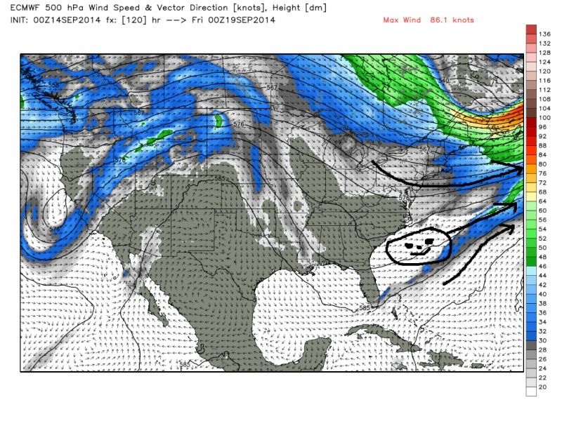
J man I am only slightly intrigued by this threat. I hope by now you have come to the conclusion that the CMC has an extreme bias to over do EVERY piece of energy involving tropical system threats. This particular threat you are referring to does have a small amt of merit though as it seems the Euro and GFS are trying to organize some energy off the SE coast with a well positioned HP to the north. The problem is this. The CMC has this thing spun up pretty tight already as is crosses the Fla Panhandle by 00z Friday which until proven otherwise is wrong. So why does the CMC bring it up the coast whereas the other models do not?
CMC 00z Friday
 " />
" />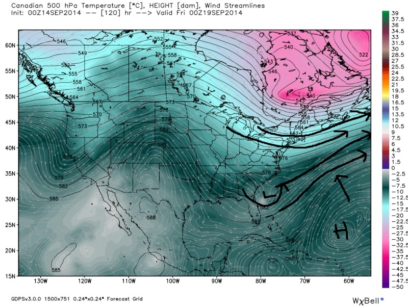 " />
" />If this system were to come off Fla that strong the strength of the system would actually aid in pumping the Atlantic ridge raising heights out ahead of it much quicker which would aid in steering it N instead of shearing it out to the NE. As it slowly drifts north it eventually gets captured by a trough(as seen by the CMC only) moving across the great Lakes and actually retrogrades it slightly before the trough sweeps through and it eventually turns it NE.
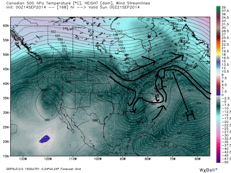
CMC 00z Sunday
 " />
" /> " />
" />The Euro and GFS however have a disorganized broad area of LP coming off the Fla Panhandle. As a result the energy has a tough time consolidating because the heights out ahead of the system never really increase to the N like seen above on the CMC and the wind flow remains to the NE shearing the system apart until the trough moves off the East coast and away she goes.
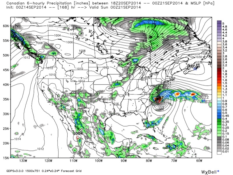
00zFriday
 " />
" /> " />
" />00zSunday
 " />
" /> " />
" />We ae going to need the heights to increase out ahead of the system as it pushes off the SE coast sooner than is currently modeled on the Euro and GFS. I personally doubt that happens, but as you can see the Euro is trying to do this, but it does so to late.
Monday 00z
 " />
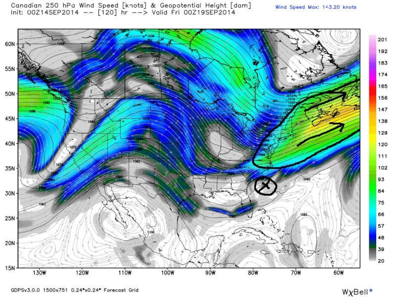
" />The one thing that is consistent on all the models; however, is a nice HP sitting over the NE US/SE Canada on Friday by 00z (see surface maps above both Euro and CMC). This is one key for development of the system as it exits the SE coast. However, an important difference I see as to why the CMC is so much stronger with the system then the Euro/GFS by 00z Friday as it comes off the Fla coast can be seen at the 250-300MB level in the atmosphere. There is a much stronger Jet streak that is centered further S and W on the CMC when compared to the Euro. This creates strong divergence aloft. When there is air racing away in the upper levels to the N and E of a system like this (we can also see this with potent Nor Easters in the winter) that creates a void in the atmosphere. This promotes rising air to the SW of the Jet Streak to replace the void in the upper levels of the atmosphere created by the streak; thus enhancing surface LP development.
00z Friday CMC 250mb
 " />
" />00z Friday Euro 300mb
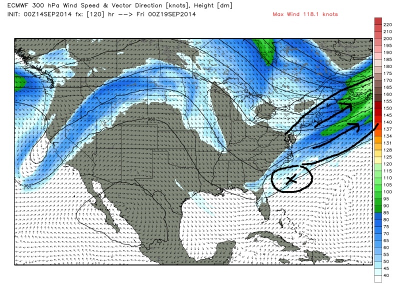 " />
" />I am not overly optimistic that this pans out to anything more than something to watch, but we shall see.
sroc4- Admin

- Posts : 8331
Join date : 2013-01-07
Re: Tropics Talk Thread 2014 1.0
![]() by jmanley32 Sun Sep 14, 2014 2:49 pm
by jmanley32 Sun Sep 14, 2014 2:49 pm

jmanley32- Senior Enthusiast
- Posts : 20516
Reputation : 108
Join date : 2013-12-12
Age : 42
Location : Yonkers, NY
Re: Tropics Talk Thread 2014 1.0
![]() by sroc4 Sun Sep 14, 2014 3:11 pm
by sroc4 Sun Sep 14, 2014 3:11 pm
Ahh man I'm so sorry to hear about your grandfather jMan. My thoughts and prayers are with you and your family. Unfortunately I have lost all my grandparents so I know how you feel right now bud. Stay busy to occupy your time and know he is headed to a better place.jmanley32 wrote:sroc, you took way to much time out of your day to do all that : ) But thanks. I have been preoccupied with my grandfather slowly passing. I noted that NHC has dropped all interest in anything in the atlantic and that to me tells me that of course CMC is on crack and Euro, although interesting that it shows a tiny bit is probably wrong too. Yes I am very aware of CMC but it is a model and no model can be completely discounted. But as for now with NHC not highlighting anything, even the wave that was to be on CMC, is gone into a broad area of LP. Maybe in 5 days time it may get better conditions but shear is high in gulf right now. I thnak you if you put my grandpa in your prayers but there is no hope, he has not eaten or had any kind of fluids in 5 days per his request and is on morphine, and my parents are up there in VT with him 12 hrs and my dads brother the other 12 hrs. They are just waiting on the day he passes. Which is making this all the more difficult on me and I am sure then even more so. So if you do not see me on much this is why plus I have a very hectic school semester and working hard on baby proofing.
_________________
"In weather and in life, there's no winning and losing; there's only winning and learning."
WINTER 2012/2013 TOTALS 43.65"WINTER 2017/2018 TOTALS 62.85" WINTER 2022/2023 TOTALS 4.9"
WINTER 2013/2014 TOTALS 64.85"WINTER 2018/2019 TOTALS 14.25" WINTER 2023/2024 TOTALS 13.1"
WINTER 2014/2015 TOTALS 71.20"WINTER 2019/2020 TOTALS 6.35"
WINTER 2015/2016 TOTALS 35.00"WINTER 2020/2021 TOTALS 37.75"
WINTER 2016/2017 TOTALS 42.25"WINTER 2021/2022 TOTALS 31.65"

sroc4- Admin
- Posts : 8331
Reputation : 301
Join date : 2013-01-07
Location : Wading River, LI
Re: Tropics Talk Thread 2014 1.0
![]() by jmanley32 Mon Sep 15, 2014 10:43 am
by jmanley32 Mon Sep 15, 2014 10:43 am
jmanley32- Senior Enthusiast
- Posts : 20516
Reputation : 108
Join date : 2013-12-12
Age : 42
Location : Yonkers, NY
Re: Tropics Talk Thread 2014 1.0
![]() by Frank_Wx Mon Sep 15, 2014 2:37 pm
by Frank_Wx Mon Sep 15, 2014 2:37 pm
_________________
_______________________________________________________________________________________________________
CLICK HERE to view NJ Strong Snowstorm Classifications

Frank_Wx- Godzilla Seeker
- Posts : 21305
Reputation : 328
Join date : 2013-01-05
Age : 31
Location : Jersey City, NJ -

Re: Tropics Talk Thread 2014 1.0
![]() by jmanley32 Wed Sep 17, 2014 1:16 pm
by jmanley32 Wed Sep 17, 2014 1:16 pm
jmanley32- Senior Enthusiast
- Posts : 20516
Reputation : 108
Join date : 2013-12-12
Age : 42
Location : Yonkers, NY
Re: Tropics Talk Thread 2014 1.0
![]() by jmanley32 Wed Sep 17, 2014 1:18 pm
by jmanley32 Wed Sep 17, 2014 1:18 pm
I realize its getting to time of year where this may not be tropical bot more a noreaster deal, but wasn't sure where I should put it.
jmanley32- Senior Enthusiast
- Posts : 20516
Reputation : 108
Join date : 2013-12-12
Age : 42
Location : Yonkers, NY
Re: Tropics Talk Thread 2014 1.0
![]() by algae888 Sun Sep 21, 2014 10:17 am
by algae888 Sun Sep 21, 2014 10:17 am

algae888- Advanced Forecaster

- Posts : 5311
Reputation : 46
Join date : 2013-02-05
Age : 61
Location : mt. vernon, new york
Re: Tropics Talk Thread 2014 1.0
![]() by jmanley32 Sun Sep 21, 2014 9:17 pm
by jmanley32 Sun Sep 21, 2014 9:17 pm
jmanley32- Senior Enthusiast
- Posts : 20516
Reputation : 108
Join date : 2013-12-12
Age : 42
Location : Yonkers, NY
Re: Tropics Talk Thread 2014 1.0
![]() by jmanley32 Thu Sep 25, 2014 3:49 pm
by jmanley32 Thu Sep 25, 2014 3:49 pm
jmanley32- Senior Enthusiast
- Posts : 20516
Reputation : 108
Join date : 2013-12-12
Age : 42
Location : Yonkers, NY
Re: Tropics Talk Thread 2014 1.0
![]() by jmanley32 Sun Sep 28, 2014 12:35 pm
by jmanley32 Sun Sep 28, 2014 12:35 pm
jmanley32- Senior Enthusiast
- Posts : 20516
Reputation : 108
Join date : 2013-12-12
Age : 42
Location : Yonkers, NY
Re: Tropics Talk Thread 2014 1.0
![]() by jmanley32 Sun Sep 28, 2014 3:38 pm
by jmanley32 Sun Sep 28, 2014 3:38 pm
So if this holds we will be moving into the 10 day period in about one or two days, lets see of CMC and Euro catch on. If not then we (for now) can assume its another GFS joke. But for now I am going to watch it.
jmanley32- Senior Enthusiast
- Posts : 20516
Reputation : 108
Join date : 2013-12-12
Age : 42
Location : Yonkers, NY
jmanley32- Senior Enthusiast
- Posts : 20516
Reputation : 108
Join date : 2013-12-12
Age : 42
Location : Yonkers, NY
jmanley32- Senior Enthusiast
- Posts : 20516
Reputation : 108
Join date : 2013-12-12
Age : 42
Location : Yonkers, NY
jmanley32- Senior Enthusiast
- Posts : 20516
Reputation : 108
Join date : 2013-12-12
Age : 42
Location : Yonkers, NY
Re: Tropics Talk Thread 2014 1.0
![]() by jmanley32 Sun Sep 28, 2014 4:02 pm
by jmanley32 Sun Sep 28, 2014 4:02 pm
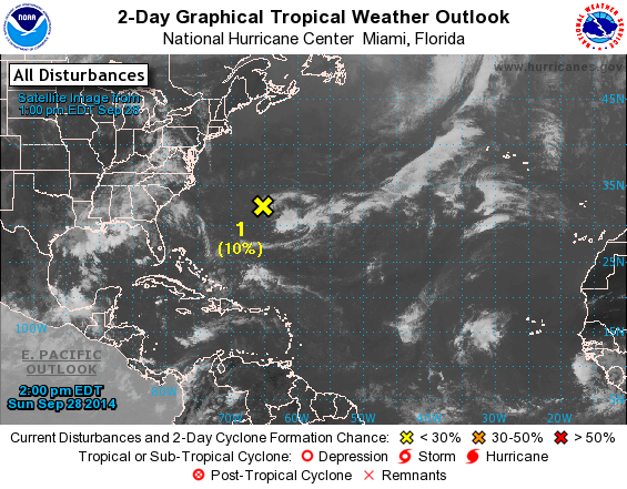
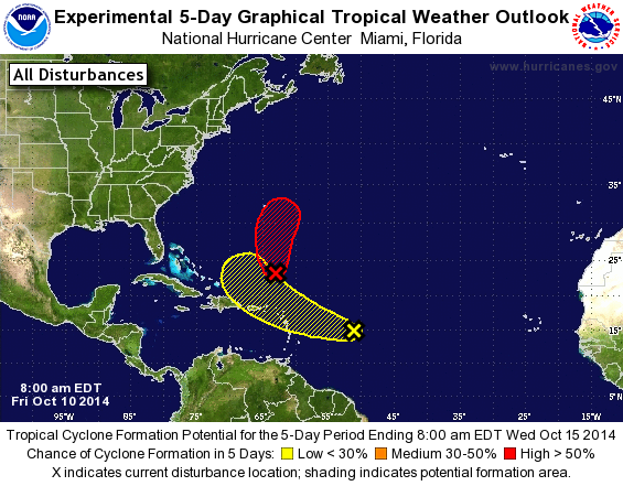
For the North Atlantic...Caribbean Sea and the Gulf of Mexico:
1. A small area of low pressure located just west of Bermuda is
producing disorganized showers and thunderstorms. Upper-level
winds are expected to remain unfavorable for significant development
during the next few days while this system moves slowly
northwestward or northward.
* Formation chance through 48 hours...low...10 percent.
* Formation chance through 5 days...low...10 percent.
jmanley32- Senior Enthusiast
- Posts : 20516
Reputation : 108
Join date : 2013-12-12
Age : 42
Location : Yonkers, NY
Re: Tropics Talk Thread 2014 1.0
![]() by jmanley32 Sat Oct 04, 2014 7:34 pm
by jmanley32 Sat Oct 04, 2014 7:34 pm
jmanley32- Senior Enthusiast
- Posts : 20516
Reputation : 108
Join date : 2013-12-12
Age : 42
Location : Yonkers, NY
Re: Tropics Talk Thread 2014 1.0
![]() by jmanley32 Wed Oct 08, 2014 4:25 pm
by jmanley32 Wed Oct 08, 2014 4:25 pm
jmanley32- Senior Enthusiast
- Posts : 20516
Reputation : 108
Join date : 2013-12-12
Age : 42
Location : Yonkers, NY
Re: Tropics Talk Thread 2014 1.0
![]() by jmanley32 Wed Oct 08, 2014 4:25 pm
by jmanley32 Wed Oct 08, 2014 4:25 pm
jmanley32- Senior Enthusiast
- Posts : 20516
Reputation : 108
Join date : 2013-12-12
Age : 42
Location : Yonkers, NY
Re: Tropics Talk Thread 2014 1.0
![]() by jmanley32 Thu Oct 09, 2014 2:52 pm
by jmanley32 Thu Oct 09, 2014 2:52 pm
jmanley32- Senior Enthusiast
- Posts : 20516
Reputation : 108
Join date : 2013-12-12
Age : 42
Location : Yonkers, NY
Re: Tropics Talk Thread 2014 1.0
![]() by jmanley32 Fri Oct 10, 2014 9:07 am
by jmanley32 Fri Oct 10, 2014 9:07 am
jmanley32- Senior Enthusiast
- Posts : 20516
Reputation : 108
Join date : 2013-12-12
Age : 42
Location : Yonkers, NY
Re: Tropics Talk Thread 2014 1.0
![]() by jmanley32 Fri Oct 10, 2014 9:09 am
by jmanley32 Fri Oct 10, 2014 9:09 am
jmanley32- Senior Enthusiast
- Posts : 20516
Reputation : 108
Join date : 2013-12-12
Age : 42
Location : Yonkers, NY
Re: Tropics Talk Thread 2014 1.0
![]() by jmanley32 Fri Oct 10, 2014 9:11 am
by jmanley32 Fri Oct 10, 2014 9:11 am
jmanley32- Senior Enthusiast
- Posts : 20516
Reputation : 108
Join date : 2013-12-12
Age : 42
Location : Yonkers, NY
Re: Tropics Talk Thread 2014 1.0
![]() by Frank_Wx Fri Oct 10, 2014 10:38 am
by Frank_Wx Fri Oct 10, 2014 10:38 am
_________________
_______________________________________________________________________________________________________
CLICK HERE to view NJ Strong Snowstorm Classifications
Frank_Wx- Godzilla Seeker
- Posts : 21305
Reputation : 328
Join date : 2013-01-05
Age : 31
Location : Jersey City, NJ -
jmanley32- Senior Enthusiast
- Posts : 20516
Reputation : 108
Join date : 2013-12-12
Age : 42
Location : Yonkers, NY
Re: Tropics Talk Thread 2014 1.0
![]() by amugs Fri Oct 10, 2014 12:58 pm
by amugs Fri Oct 10, 2014 12:58 pm
Looking at the hmm - interpretation - things are getting interesting - peeking his interest - teh set up at Scott made mention and I looked the MJO Phase octane map and the atmospheric set up down the road - late next week and beyond looks to be interesting but then again it all can change. We shall see.
Mugs
_________________
Mugs
AKA:King: Snow Weenie
Self Proclaimed
WINTER 2014-15 : 55.12" +.02 for 6 coatings (avg. 35")
WINTER 2015-16 Total - 29.8" (Avg 35")
WINTER 2016-17 : 39.5" so far

amugs- Advanced Forecaster - Mod

- Posts : 15093
Reputation : 213
Join date : 2013-01-07
Age : 54
Location : Hillsdale,NJ
Page 14 of 16 • 1 ... 8 ... 13, 14, 15, 16 ![]()
|
|
|