
 Search
June 2014 Observations / Discussions Thread
Page 3 of 6 •  1, 2, 3, 4, 5, 6
 ![]()
Re: June 2014 Observations / Discussions Thread
![]() by Frank_Wx Fri Jun 13, 2014 3:29 pm
by Frank_Wx Fri Jun 13, 2014 3:29 pm
Frank_Wx- Godzilla Seeker

- Posts : 21305
Join date : 2013-01-05 -

Re: June 2014 Observations / Discussions Thread
![]() by Dtone Fri Jun 13, 2014 3:32 pm
by Dtone Fri Jun 13, 2014 3:32 pm
When do you think that line of storms will reach NYC?
Dtone- Wx Statistician Guru

- Posts : 1738
Join date : 2013-08-26
Re: June 2014 Observations / Discussions Thread
![]() by Frank_Wx Fri Jun 13, 2014 3:34 pm
by Frank_Wx Fri Jun 13, 2014 3:34 pm
_________________
_______________________________________________________________________________________________________
CLICK HERE to view NJ Strong Snowstorm Classifications

Frank_Wx- Godzilla Seeker
- Posts : 21305
Reputation : 328
Join date : 2013-01-05
Age : 31
Location : Jersey City, NJ -
Re: June 2014 Observations / Discussions Thread
![]() by Frank_Wx Fri Jun 13, 2014 3:35 pm
by Frank_Wx Fri Jun 13, 2014 3:35 pm
Dtone wrote:The sun is out now, temp up to 77* dewpoint 70*
When do you think that line of storms will reach NYC?
Probably not until 4:30-5:00pm
_________________
_______________________________________________________________________________________________________
CLICK HERE to view NJ Strong Snowstorm Classifications
Frank_Wx- Godzilla Seeker
- Posts : 21305
Reputation : 328
Join date : 2013-01-05
Age : 31
Location : Jersey City, NJ -
Re: June 2014 Observations / Discussions Thread
![]() by Frank_Wx Fri Jun 13, 2014 3:37 pm
by Frank_Wx Fri Jun 13, 2014 3:37 pm
http://radar.weather.gov/radar.php?rid=dix&product=N0R&overlay=11101111&loop=yes
_________________
_______________________________________________________________________________________________________
CLICK HERE to view NJ Strong Snowstorm Classifications
Frank_Wx- Godzilla Seeker
- Posts : 21305
Reputation : 328
Join date : 2013-01-05
Age : 31
Location : Jersey City, NJ -
Re: June 2014 Observations / Discussions Thread
![]() by Frank_Wx Fri Jun 13, 2014 4:10 pm
by Frank_Wx Fri Jun 13, 2014 4:10 pm
_________________
_______________________________________________________________________________________________________
CLICK HERE to view NJ Strong Snowstorm Classifications
Frank_Wx- Godzilla Seeker
- Posts : 21305
Reputation : 328
Join date : 2013-01-05
Age : 31
Location : Jersey City, NJ -
Re: June 2014 Observations / Discussions Thread
![]() by Frank_Wx Fri Jun 13, 2014 4:52 pm
by Frank_Wx Fri Jun 13, 2014 4:52 pm
_________________
_______________________________________________________________________________________________________
CLICK HERE to view NJ Strong Snowstorm Classifications
Frank_Wx- Godzilla Seeker
- Posts : 21305
Reputation : 328
Join date : 2013-01-05
Age : 31
Location : Jersey City, NJ -
Re: June 2014 Observations / Discussions Thread
![]() by jmanley32 Fri Jun 13, 2014 6:32 pm
by jmanley32 Fri Jun 13, 2014 6:32 pm

jmanley32- Senior Enthusiast

- Posts : 20516
Reputation : 108
Join date : 2013-12-12
Age : 42
Location : Yonkers, NY
Re: June 2014 Observations / Discussions Thread
![]() by Dtone Fri Jun 13, 2014 6:41 pm
by Dtone Fri Jun 13, 2014 6:41 pm
Dtone- Wx Statistician Guru
- Posts : 1738
Reputation : 9
Join date : 2013-08-26
Location : Bronx, NY
Re: June 2014 Observations / Discussions Thread
![]() by Dunnzoo Fri Jun 13, 2014 6:51 pm
by Dunnzoo Fri Jun 13, 2014 6:51 pm
_________________
Janet
Snowfall winter of 2023-2024 17.5"
Snowfall winter of 2022-2023 6.0"
Snowfall winter of 2021-2022 17.6" 1" sleet 2/25/22
Snowfall winter of 2020-2021 51.1"
Snowfall winter of 2019-2020 8.5"
Snowfall winter of 2018-2019 25.1"
Snowfall winter of 2017-2018 51.9"
Snowfall winter of 2016-2017 45.6"
Snowfall winter of 2015-2016 29.5"
Snowfall winter of 2014-2015 50.55"
Snowfall winter of 2013-2014 66.5"

Dunnzoo- Senior Enthusiast - Mod

- Posts : 4891
Reputation : 68
Join date : 2013-01-11
Age : 62
Location : Westwood, NJ
Re: June 2014 Observations / Discussions Thread
![]() by Snow88 Sat Jun 14, 2014 10:19 am
by Snow88 Sat Jun 14, 2014 10:19 am

Snow88- Senior Enthusiast
- Posts : 2193
Reputation : 4
Join date : 2013-01-09
Age : 35
Location : Brooklyn, NY
Re: June 2014 Observations / Discussions Thread
![]() by amugs Sat Jun 14, 2014 12:50 pm
by amugs Sat Jun 14, 2014 12:50 pm
-EPO still driving our weather? SST's in the eatstern pacific are crazy warm! What will this lead to - only time will tell.
_________________
Mugs
AKA:King: Snow Weenie
Self Proclaimed
WINTER 2014-15 : 55.12" +.02 for 6 coatings (avg. 35")
WINTER 2015-16 Total - 29.8" (Avg 35")
WINTER 2016-17 : 39.5" so far

amugs- Advanced Forecaster - Mod
- Posts : 15093
Reputation : 213
Join date : 2013-01-07
Age : 54
Location : Hillsdale,NJ
Re: June 2014 Observations / Discussions Thread
![]() by Frank_Wx Sat Jun 14, 2014 9:36 pm
by Frank_Wx Sat Jun 14, 2014 9:36 pm
_________________
_______________________________________________________________________________________________________
CLICK HERE to view NJ Strong Snowstorm Classifications
Frank_Wx- Godzilla Seeker
- Posts : 21305
Reputation : 328
Join date : 2013-01-05
Age : 31
Location : Jersey City, NJ -
Re: June 2014 Observations / Discussions Thread
![]() by Snow88 Sun Jun 15, 2014 1:06 am
by Snow88 Sun Jun 15, 2014 1:06 am
Snow88- Senior Enthusiast
- Posts : 2193
Reputation : 4
Join date : 2013-01-09
Age : 35
Location : Brooklyn, NY
Re: June 2014 Observations / Discussions Thread
![]() by Frank_Wx Sun Jun 15, 2014 9:54 am
by Frank_Wx Sun Jun 15, 2014 9:54 am
_________________
_______________________________________________________________________________________________________
CLICK HERE to view NJ Strong Snowstorm Classifications
Frank_Wx- Godzilla Seeker
- Posts : 21305
Reputation : 328
Join date : 2013-01-05
Age : 31
Location : Jersey City, NJ -
Re: June 2014 Observations / Discussions Thread
![]() by Frank_Wx Mon Jun 16, 2014 9:44 am
by Frank_Wx Mon Jun 16, 2014 9:44 am
_________________
_______________________________________________________________________________________________________
CLICK HERE to view NJ Strong Snowstorm Classifications
Frank_Wx- Godzilla Seeker
- Posts : 21305
Reputation : 328
Join date : 2013-01-05
Age : 31
Location : Jersey City, NJ -
Re: June 2014 Observations / Discussions Thread
![]() by HectorO Mon Jun 16, 2014 5:45 pm
by HectorO Mon Jun 16, 2014 5:45 pm

HectorO- Pro Enthusiast

- Posts : 959
Reputation : 27
Join date : 2013-01-11
Re: June 2014 Observations / Discussions Thread
![]() by Frank_Wx Tue Jun 17, 2014 12:32 am
by Frank_Wx Tue Jun 17, 2014 12:32 am
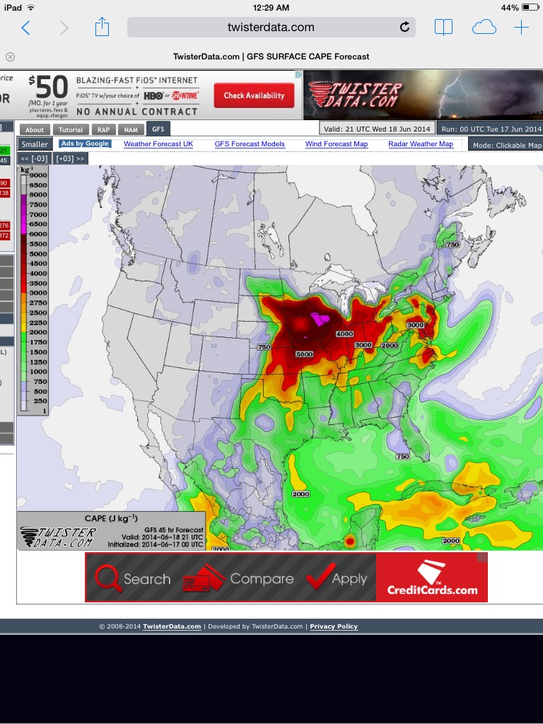
There's enough instability Wednesday for severe storms to develop between 2-9pm
_________________
_______________________________________________________________________________________________________
CLICK HERE to view NJ Strong Snowstorm Classifications
Frank_Wx- Godzilla Seeker
- Posts : 21305
Reputation : 328
Join date : 2013-01-05
Age : 31
Location : Jersey City, NJ -
Re: June 2014 Observations / Discussions Thread
![]() by Quietace Tue Jun 17, 2014 7:25 am
by Quietace Tue Jun 17, 2014 7:25 am

Quietace- Meteorologist - Mod

- Posts : 3687
Reputation : 33
Join date : 2013-01-07
Age : 27
Location : Point Pleasant, NJ
Re: June 2014 Observations / Discussions Thread
![]() by Dtone Tue Jun 17, 2014 8:31 am
by Dtone Tue Jun 17, 2014 8:31 am
dew 61*
Dtone- Wx Statistician Guru
- Posts : 1738
Reputation : 9
Join date : 2013-08-26
Location : Bronx, NY
Snow88- Senior Enthusiast
- Posts : 2193
Reputation : 4
Join date : 2013-01-09
Age : 35
Location : Brooklyn, NY
Re: June 2014 Observations / Discussions Thread
![]() by Snow88 Tue Jun 17, 2014 10:00 am
by Snow88 Tue Jun 17, 2014 10:00 am
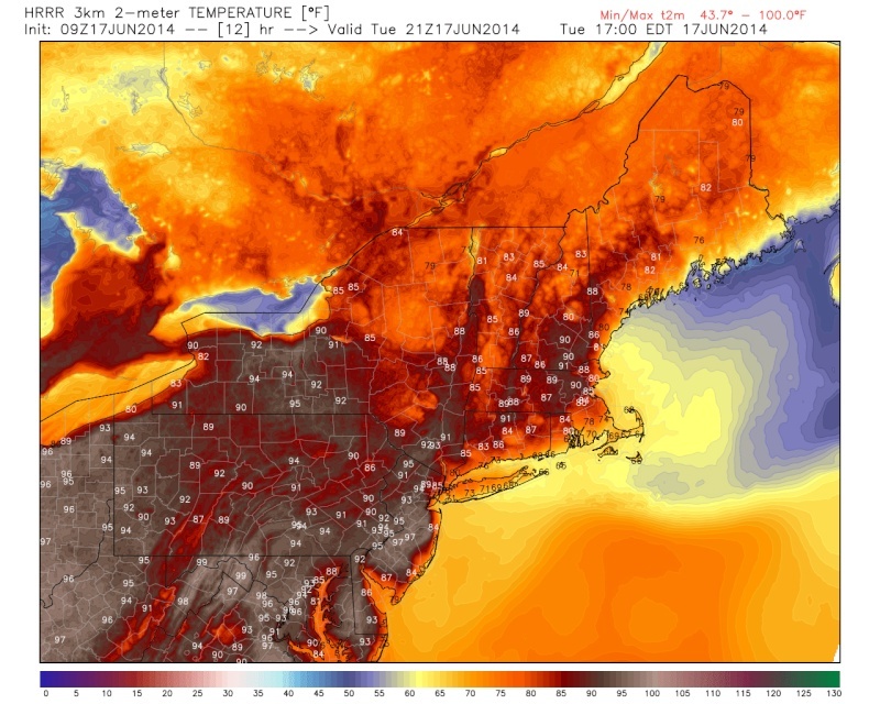
Quietace wrote:The HRRR wants us to melt today
Living near the ocean FTW
Snow88- Senior Enthusiast
- Posts : 2193
Reputation : 4
Join date : 2013-01-09
Age : 35
Location : Brooklyn, NY
Re: June 2014 Observations / Discussions Thread
![]() by Dunnzoo Tue Jun 17, 2014 10:15 am
by Dunnzoo Tue Jun 17, 2014 10:15 am
_________________
Janet
Snowfall winter of 2023-2024 17.5"
Snowfall winter of 2022-2023 6.0"
Snowfall winter of 2021-2022 17.6" 1" sleet 2/25/22
Snowfall winter of 2020-2021 51.1"
Snowfall winter of 2019-2020 8.5"
Snowfall winter of 2018-2019 25.1"
Snowfall winter of 2017-2018 51.9"
Snowfall winter of 2016-2017 45.6"
Snowfall winter of 2015-2016 29.5"
Snowfall winter of 2014-2015 50.55"
Snowfall winter of 2013-2014 66.5"
Dunnzoo- Senior Enthusiast - Mod
- Posts : 4891
Reputation : 68
Join date : 2013-01-11
Age : 62
Location : Westwood, NJ
Re: June 2014 Observations / Discussions Thread
![]() by jmanley32 Tue Jun 17, 2014 10:40 am
by jmanley32 Tue Jun 17, 2014 10:40 am
On a more interesting note I had a question if anyone has the answer it would be cool or any ideas.
So...whenever a line of t-storms does make it past the mountains and comes towards me it will appear to be knocking on my doorstep sometimes as close as just across the Hudson River from me and then as it crosses (and only in the confines of the Yonkers area, will break up or split to the north and or south. Does Yonkers have some kind of affect on the storms, is therte something in this spot they do not like. I have just noticed this many many times, we get few severe t-storms right in my backyard while just to the north gets pummeled or to the south in the Bronx/Manhattan. Any clue? Hope everyone is good and had a good fathers day whom of you are fathers like myself.
jmanley32- Senior Enthusiast
- Posts : 20516
Reputation : 108
Join date : 2013-12-12
Age : 42
Location : Yonkers, NY
Re: June 2014 Observations / Discussions Thread
![]() by jmanley32 Tue Jun 17, 2014 10:50 am
by jmanley32 Tue Jun 17, 2014 10:50 am
jmanley32- Senior Enthusiast
- Posts : 20516
Reputation : 108
Join date : 2013-12-12
Age : 42
Location : Yonkers, NY
Re: June 2014 Observations / Discussions Thread
![]() by HectorO Tue Jun 17, 2014 11:46 am
by HectorO Tue Jun 17, 2014 11:46 am
HectorO- Pro Enthusiast
- Posts : 959
Reputation : 27
Join date : 2013-01-11
Re: June 2014 Observations / Discussions Thread
![]() by Frank_Wx Tue Jun 17, 2014 12:03 pm
by Frank_Wx Tue Jun 17, 2014 12:03 pm
_________________
_______________________________________________________________________________________________________
CLICK HERE to view NJ Strong Snowstorm Classifications
Frank_Wx- Godzilla Seeker
- Posts : 21305
Reputation : 328
Join date : 2013-01-05
Age : 31
Location : Jersey City, NJ -
Page 3 of 6 • 1, 2, 3, 4, 5, 6 ![]()
|
|
|