
 Search
*BLOG: Halloween Forecast
Page 1 of 13 • 1, 2, 3 ... 11, 12, 13 ![]()

*BLOG: Halloween Forecast
![]() by Frank_Wx Sun Oct 26, 2014 11:42 pm
by Frank_Wx Sun Oct 26, 2014 11:42 pm
http://njstrongweather.blogspot.com/2014/10/halloween-forecast-november-outlook.html
Frank
_________________
_______________________________________________________________________________________________________
CLICK HERE to view NJ Strong Snowstorm Classifications

Frank_Wx- Godzilla Seeker

- Posts : 21305
Reputation : 328
Join date : 2013-01-05
Age : 31
Location : Jersey City, NJ -

Re: *BLOG: Halloween Forecast
![]() by aiannone Sun Oct 26, 2014 11:55 pm
by aiannone Sun Oct 26, 2014 11:55 pm
_________________
-Alex Iannone-

aiannone- Senior Enthusiast - Mod

- Posts : 4813
Reputation : 92
Join date : 2013-01-07
Location : Saint James, LI (Northwest Suffolk Co.)
Re: *BLOG: Halloween Forecast
![]() by Frank_Wx Sun Oct 26, 2014 11:57 pm
by Frank_Wx Sun Oct 26, 2014 11:57 pm
Mets2695 wrote:Great write up Frank. As of now, myself and several other students agree with what you just said. We are currently forecasting light rain showers transitioning to snow showers here with minor accumulations, but possibly up to a few inches up in the Green Mountains.
Yup, I can definitely see that up by you.
_________________
_______________________________________________________________________________________________________
CLICK HERE to view NJ Strong Snowstorm Classifications
Frank_Wx- Godzilla Seeker
- Posts : 21305
Reputation : 328
Join date : 2013-01-05
Age : 31
Location : Jersey City, NJ -
Re: *BLOG: Halloween Forecast
![]() by Frank_Wx Sun Oct 26, 2014 11:57 pm
by Frank_Wx Sun Oct 26, 2014 11:57 pm
_________________
_______________________________________________________________________________________________________
CLICK HERE to view NJ Strong Snowstorm Classifications
Frank_Wx- Godzilla Seeker
- Posts : 21305
Reputation : 328
Join date : 2013-01-05
Age : 31
Location : Jersey City, NJ -
Re: *BLOG: Halloween Forecast
![]() by aiannone Mon Oct 27, 2014 12:05 am
by aiannone Mon Oct 27, 2014 12:05 am
_________________
-Alex Iannone-
aiannone- Senior Enthusiast - Mod
- Posts : 4813
Reputation : 92
Join date : 2013-01-07
Location : Saint James, LI (Northwest Suffolk Co.)
Re: *BLOG: Halloween Forecast
![]() by aiannone Mon Oct 27, 2014 12:09 am
by aiannone Mon Oct 27, 2014 12:09 am
_________________
-Alex Iannone-
aiannone- Senior Enthusiast - Mod
- Posts : 4813
Reputation : 92
Join date : 2013-01-07
Location : Saint James, LI (Northwest Suffolk Co.)
Re: *BLOG: Halloween Forecast
![]() by Frank_Wx Mon Oct 27, 2014 12:09 am
by Frank_Wx Mon Oct 27, 2014 12:09 am
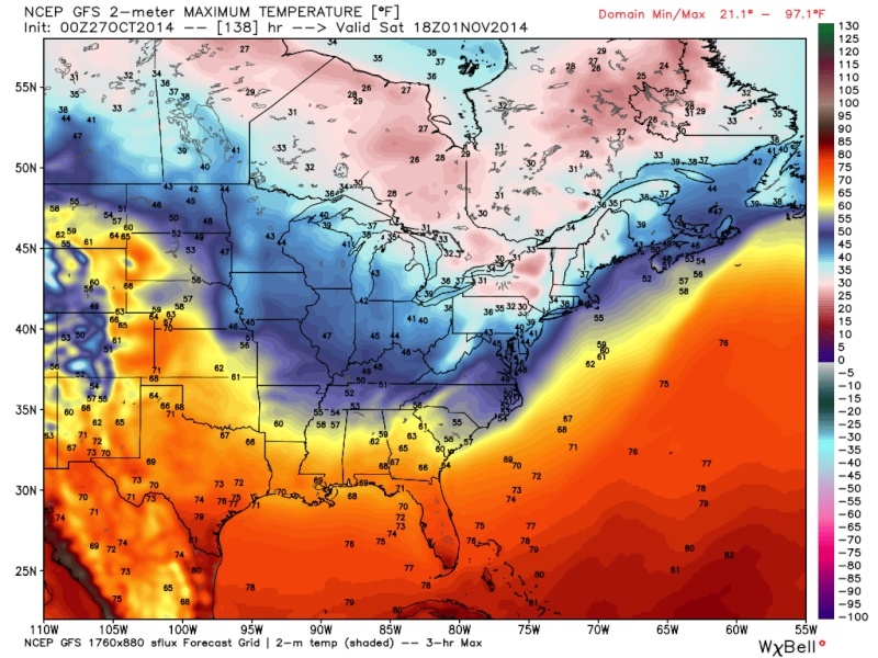
GFS coming in looking a little weaker than previous ones. Pretty much follows my forecast as well as yours. At hour 135 it looks like Vermont is getting snow.
_________________
_______________________________________________________________________________________________________
CLICK HERE to view NJ Strong Snowstorm Classifications
Frank_Wx- Godzilla Seeker
- Posts : 21305
Reputation : 328
Join date : 2013-01-05
Age : 31
Location : Jersey City, NJ -
Re: *BLOG: Halloween Forecast
![]() by Frank_Wx Mon Oct 27, 2014 12:10 am
by Frank_Wx Mon Oct 27, 2014 12:10 am
_________________
_______________________________________________________________________________________________________
CLICK HERE to view NJ Strong Snowstorm Classifications
Frank_Wx- Godzilla Seeker
- Posts : 21305
Reputation : 328
Join date : 2013-01-05
Age : 31
Location : Jersey City, NJ -
Re: *BLOG: Halloween Forecast
![]() by aiannone Mon Oct 27, 2014 12:15 am
by aiannone Mon Oct 27, 2014 12:15 am
_________________
-Alex Iannone-
aiannone- Senior Enthusiast - Mod
- Posts : 4813
Reputation : 92
Join date : 2013-01-07
Location : Saint James, LI (Northwest Suffolk Co.)
Re: *BLOG: Halloween Forecast
![]() by aiannone Mon Oct 27, 2014 12:29 am
by aiannone Mon Oct 27, 2014 12:29 am
_________________
-Alex Iannone-
aiannone- Senior Enthusiast - Mod
- Posts : 4813
Reputation : 92
Join date : 2013-01-07
Location : Saint James, LI (Northwest Suffolk Co.)
Re: *BLOG: Halloween Forecast
![]() by aiannone Mon Oct 27, 2014 12:40 am
by aiannone Mon Oct 27, 2014 12:40 am
_________________
-Alex Iannone-
aiannone- Senior Enthusiast - Mod
- Posts : 4813
Reputation : 92
Join date : 2013-01-07
Location : Saint James, LI (Northwest Suffolk Co.)
Re: *BLOG: Halloween Forecast
![]() by jmanley32 Mon Oct 27, 2014 6:41 am
by jmanley32 Mon Oct 27, 2014 6:41 am

jmanley32- Senior Enthusiast

- Posts : 20516
Reputation : 108
Join date : 2013-12-12
Age : 42
Location : Yonkers, NY
Re: *BLOG: Halloween Forecast
![]() by sroc4 Mon Oct 27, 2014 8:53 am
by sroc4 Mon Oct 27, 2014 8:53 am
_________________
"In weather and in life, there's no winning and losing; there's only winning and learning."
WINTER 2012/2013 TOTALS 43.65"WINTER 2017/2018 TOTALS 62.85" WINTER 2022/2023 TOTALS 4.9"
WINTER 2013/2014 TOTALS 64.85"WINTER 2018/2019 TOTALS 14.25" WINTER 2023/2024 TOTALS 13.1"
WINTER 2014/2015 TOTALS 71.20"WINTER 2019/2020 TOTALS 6.35"
WINTER 2015/2016 TOTALS 35.00"WINTER 2020/2021 TOTALS 37.75"
WINTER 2016/2017 TOTALS 42.25"WINTER 2021/2022 TOTALS 31.65"

sroc4- Admin
- Posts : 8331
Reputation : 301
Join date : 2013-01-07
Location : Wading River, LI
Re: *BLOG: Halloween Forecast
![]() by amugs Mon Oct 27, 2014 8:57 am
by amugs Mon Oct 27, 2014 8:57 am
_________________
Mugs
AKA:King: Snow Weenie
Self Proclaimed
WINTER 2014-15 : 55.12" +.02 for 6 coatings (avg. 35")
WINTER 2015-16 Total - 29.8" (Avg 35")
WINTER 2016-17 : 39.5" so far

amugs- Advanced Forecaster - Mod
- Posts : 15093
Reputation : 213
Join date : 2013-01-07
Age : 54
Location : Hillsdale,NJ
Re: *BLOG: Halloween Forecast
![]() by Frank_Wx Mon Oct 27, 2014 9:18 am
by Frank_Wx Mon Oct 27, 2014 9:18 am
_________________
_______________________________________________________________________________________________________
CLICK HERE to view NJ Strong Snowstorm Classifications
Frank_Wx- Godzilla Seeker
- Posts : 21305
Reputation : 328
Join date : 2013-01-05
Age : 31
Location : Jersey City, NJ -
Re: *BLOG: Halloween Forecast
![]() by Frank_Wx Mon Oct 27, 2014 9:21 am
by Frank_Wx Mon Oct 27, 2014 9:21 am
_________________
_______________________________________________________________________________________________________
CLICK HERE to view NJ Strong Snowstorm Classifications
Frank_Wx- Godzilla Seeker
- Posts : 21305
Reputation : 328
Join date : 2013-01-05
Age : 31
Location : Jersey City, NJ -
Re: *BLOG: Halloween Forecast
![]() by jmanley32 Mon Oct 27, 2014 9:34 am
by jmanley32 Mon Oct 27, 2014 9:34 am
Apparently according to JB (have not checked yet) The UKMET shows a phase bringing a storm for us and he feels that the Euro and GFS are coming on board. I think he is wishcasting at this point because things are still dicy like has been said not until tomorrow into Wednesday will thingsd start to come together.
jmanley32- Senior Enthusiast
- Posts : 20516
Reputation : 108
Join date : 2013-12-12
Age : 42
Location : Yonkers, NY
Re: *BLOG: Halloween Forecast
![]() by aiannone Mon Oct 27, 2014 10:50 am
by aiannone Mon Oct 27, 2014 10:50 am
THE NORTH COUNTRY FRIDAY NIGHT AND SATURDAY WITH LOWS FRIDAY NIGHT IN THE 20S AND LOWER 30S. EXPECTING ANY RAIN EARLY FRIDAY NIGHT WILL CHANGE TO SNOW...ESPECIALLY OVER THE HIGHER ELEVATIONS. EVEN VALLEY LOCATIONS SUCH AS THE CHAMPLAIN VALLEY AND THE SAINT LAWRENCE VALLEY COULD SEE THE SEASONS FIRST SNOWFALL LATE FRIDAY NIGHT AND SATURDAY. HIGHS ON SATURDAY WILL ONLY BE IN THE 30S ACROSS THE REGION. GFS MODEL A BIT MORE PROGRESSIVE WITH MOVING THE CLOSED UPPER LOW EAST OF THE REGION SATURDAY NIGHT...WHILE THE ECMWF IS SLOWER. THE ECMWF MODEL IS SUGGESTING WRAP AROUND MOISTURE PRODUCING SNOW OVER THE UPSLOPE AREAS OF THE GREEN MOUNTAINS SATURDAY NIGHT. EXPECTING HIGH PRESSURE TO BUILD INTO
THE REGION ON SUNDAY.
_________________
-Alex Iannone-
aiannone- Senior Enthusiast - Mod
- Posts : 4813
Reputation : 92
Join date : 2013-01-07
Location : Saint James, LI (Northwest Suffolk Co.)
Re: *BLOG: Halloween Forecast
![]() by Frank_Wx Mon Oct 27, 2014 12:02 pm
by Frank_Wx Mon Oct 27, 2014 12:02 pm

_________________
_______________________________________________________________________________________________________
CLICK HERE to view NJ Strong Snowstorm Classifications
Frank_Wx- Godzilla Seeker
- Posts : 21305
Reputation : 328
Join date : 2013-01-05
Age : 31
Location : Jersey City, NJ -
Re: *BLOG: Halloween Forecast
![]() by Frank_Wx Mon Oct 27, 2014 12:03 pm
by Frank_Wx Mon Oct 27, 2014 12:03 pm

_________________
_______________________________________________________________________________________________________
CLICK HERE to view NJ Strong Snowstorm Classifications
Frank_Wx- Godzilla Seeker
- Posts : 21305
Reputation : 328
Join date : 2013-01-05
Age : 31
Location : Jersey City, NJ -
Re: *BLOG: Halloween Forecast
![]() by Frank_Wx Mon Oct 27, 2014 12:06 pm
by Frank_Wx Mon Oct 27, 2014 12:06 pm

If this solution is correct, throw my blog out the window. The GFS dug the northern stream vort instead of meandering it around the Great Lakes. Gives us a Miller-B type of solution
_________________
_______________________________________________________________________________________________________
CLICK HERE to view NJ Strong Snowstorm Classifications
Frank_Wx- Godzilla Seeker
- Posts : 21305
Reputation : 328
Join date : 2013-01-05
Age : 31
Location : Jersey City, NJ -
Re: *BLOG: Halloween Forecast
![]() by Frank_Wx Mon Oct 27, 2014 12:10 pm
by Frank_Wx Mon Oct 27, 2014 12:10 pm

_________________
_______________________________________________________________________________________________________
CLICK HERE to view NJ Strong Snowstorm Classifications
Frank_Wx- Godzilla Seeker
- Posts : 21305
Reputation : 328
Join date : 2013-01-05
Age : 31
Location : Jersey City, NJ -
Re: *BLOG: Halloween Forecast
![]() by Frank_Wx Mon Oct 27, 2014 12:16 pm
by Frank_Wx Mon Oct 27, 2014 12:16 pm

_________________
_______________________________________________________________________________________________________
CLICK HERE to view NJ Strong Snowstorm Classifications
Frank_Wx- Godzilla Seeker
- Posts : 21305
Reputation : 328
Join date : 2013-01-05
Age : 31
Location : Jersey City, NJ -


Snow88- Senior Enthusiast
- Posts : 2193
Reputation : 4
Join date : 2013-01-09
Age : 35
Location : Brooklyn, NY
Re: *BLOG: Halloween Forecast
![]() by Frank_Wx Mon Oct 27, 2014 12:27 pm
by Frank_Wx Mon Oct 27, 2014 12:27 pm

_________________
_______________________________________________________________________________________________________
CLICK HERE to view NJ Strong Snowstorm Classifications
Frank_Wx- Godzilla Seeker
- Posts : 21305
Reputation : 328
Join date : 2013-01-05
Age : 31
Location : Jersey City, NJ -
Page 1 of 13 • 1, 2, 3 ... 11, 12, 13 ![]()
|
|
|