
 Search
*BLOG: Halloween Forecast
Page 11 of 13 •  1, 2, 3 ... 10, 11, 12, 13
 ![]()
Re: *BLOG: Halloween Forecast
![]() by amugs Tue Oct 28, 2014 3:15 pm
by amugs Tue Oct 28, 2014 3:15 pm
amugs- Advanced Forecaster - Mod

- Posts : 15093
Join date : 2013-01-07
Re: *BLOG: Halloween Forecast
![]() by skinsfan1177 Tue Oct 28, 2014 3:25 pm
by skinsfan1177 Tue Oct 28, 2014 3:25 pm
skinsfan1177- Senior Enthusiast

- Posts : 4485
Join date : 2013-01-07
Re: *BLOG: Halloween Forecast
![]() by jmanley32 Tue Oct 28, 2014 3:28 pm
by jmanley32 Tue Oct 28, 2014 3:28 pm

jmanley32- Senior Enthusiast
- Posts : 20517
Reputation : 108
Join date : 2013-12-12
Age : 42
Location : Yonkers, NY
Re: *BLOG: Halloween Forecast
![]() by jmanley32 Tue Oct 28, 2014 3:29 pm
by jmanley32 Tue Oct 28, 2014 3:29 pm
jmanley32- Senior Enthusiast
- Posts : 20517
Reputation : 108
Join date : 2013-12-12
Age : 42
Location : Yonkers, NY
Re: *BLOG: Halloween Forecast
![]() by mako460 Tue Oct 28, 2014 3:34 pm
by mako460 Tue Oct 28, 2014 3:34 pm
mako460- Pro Enthusiast

- Posts : 346
Reputation : 4
Join date : 2013-01-09
Age : 57
Location : Gerritsen Beach Brooklyn
jmanley32- Senior Enthusiast
- Posts : 20517
Reputation : 108
Join date : 2013-12-12
Age : 42
Location : Yonkers, NY
Re: *BLOG: Halloween Forecast
![]() by aiannone Tue Oct 28, 2014 3:49 pm
by aiannone Tue Oct 28, 2014 3:49 pm
_________________
-Alex Iannone-

aiannone- Senior Enthusiast - Mod
- Posts : 4814
Reputation : 92
Join date : 2013-01-07
Location : Saint James, LI (Northwest Suffolk Co.)
Re: *BLOG: Halloween Forecast
![]() by jmanley32 Tue Oct 28, 2014 3:53 pm
by jmanley32 Tue Oct 28, 2014 3:53 pm
http://www.accuweather.com/en/weather-video/cold-snow-for-halloween-weeke/90462062001?channel=top_story
jmanley32- Senior Enthusiast
- Posts : 20517
Reputation : 108
Join date : 2013-12-12
Age : 42
Location : Yonkers, NY
Re: *BLOG: Halloween Forecast
![]() by Frank_Wx Tue Oct 28, 2014 4:03 pm
by Frank_Wx Tue Oct 28, 2014 4:03 pm

_________________
_______________________________________________________________________________________________________
CLICK HERE to view NJ Strong Snowstorm Classifications

Frank_Wx- Godzilla Seeker

- Posts : 21305
Reputation : 328
Join date : 2013-01-05
Age : 31
Location : Jersey City, NJ -

Re: *BLOG: Halloween Forecast
![]() by jmanley32 Tue Oct 28, 2014 4:05 pm
by jmanley32 Tue Oct 28, 2014 4:05 pm
jmanley32- Senior Enthusiast
- Posts : 20517
Reputation : 108
Join date : 2013-12-12
Age : 42
Location : Yonkers, NY
Re: *BLOG: Halloween Forecast
![]() by aiannone Tue Oct 28, 2014 4:06 pm
by aiannone Tue Oct 28, 2014 4:06 pm
_________________
-Alex Iannone-
aiannone- Senior Enthusiast - Mod
- Posts : 4814
Reputation : 92
Join date : 2013-01-07
Location : Saint James, LI (Northwest Suffolk Co.)
Re: *BLOG: Halloween Forecast
![]() by jmanley32 Tue Oct 28, 2014 4:07 pm
by jmanley32 Tue Oct 28, 2014 4:07 pm
jmanley32- Senior Enthusiast
- Posts : 20517
Reputation : 108
Join date : 2013-12-12
Age : 42
Location : Yonkers, NY
Re: *BLOG: Halloween Forecast
![]() by sroc4 Tue Oct 28, 2014 4:11 pm
by sroc4 Tue Oct 28, 2014 4:11 pm
Frank_Wx wrote:EURO looks like a late phase, but it has the ridge axis further west which I like. We still get some rain to maybe snow showers. EURO went with the GFS idea of digging the northern stream too far south.
Yup but the surface Low still travels pretty close to the BM. Actually just S and E of the BM.
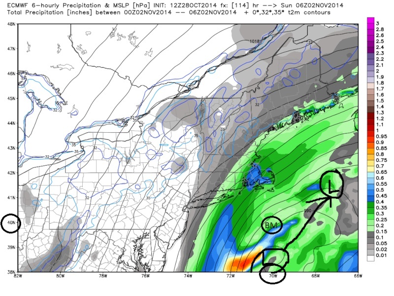 " />
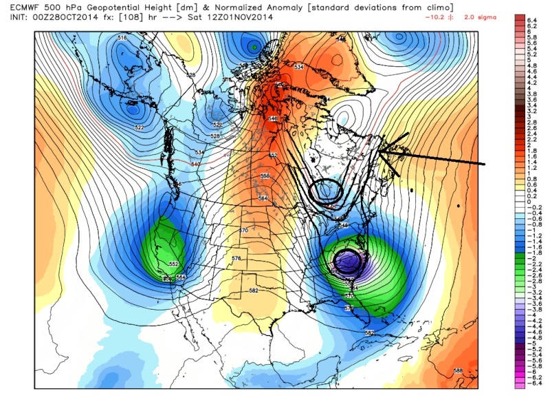
" />In addition to the Ridge axis a tad more west, the other thing I would like to see happen to this Euro run over the next 24-48hrs is to get rid of the area of diffluence earlier seen just above the GL by 12z Sat circled in black. If that area could break down earlier it would cause the arctic air to race to our storm bombing it out quicker, and more importantly cause the blocking in the Atlantic to buckle the stream causing the LP center to come back N and West earlier and we would be in some serious business. Instead it persist until about 6z-12z Sunday. By then its too late the center of LP has already gained too much latitude and passes too far east before really bombing out for major impacts.
 " />
" /> " />
" /> " />
" />Here is 18z Sunday. When that area of diffluence breaks down it allows the blocking to build in over the top too late turning the LP back into Maine indicated by the Red arrow coming off the Carolina coast. We need that area of diffluence breaks down earlier. If it does we would get a track more like the blue arrow coming off the Carolina coast, and whoa baby watch out if that happens.
 " />
" />_________________
"In weather and in life, there's no winning and losing; there's only winning and learning."
WINTER 2012/2013 TOTALS 43.65"WINTER 2017/2018 TOTALS 62.85" WINTER 2022/2023 TOTALS 4.9"
WINTER 2013/2014 TOTALS 64.85"WINTER 2018/2019 TOTALS 14.25" WINTER 2023/2024 TOTALS 13.1"
WINTER 2014/2015 TOTALS 71.20"WINTER 2019/2020 TOTALS 6.35"
WINTER 2015/2016 TOTALS 35.00"WINTER 2020/2021 TOTALS 37.75"
WINTER 2016/2017 TOTALS 42.25"WINTER 2021/2022 TOTALS 31.65"

sroc4- Admin
- Posts : 8331
Reputation : 301
Join date : 2013-01-07
Location : Wading River, LI
Re: *BLOG: Halloween Forecast
![]() by sroc4 Tue Oct 28, 2014 4:11 pm
by sroc4 Tue Oct 28, 2014 4:11 pm
Frank_Wx wrote:EURO Ensembles are a hit
Giggidy
_________________
"In weather and in life, there's no winning and losing; there's only winning and learning."
WINTER 2012/2013 TOTALS 43.65"WINTER 2017/2018 TOTALS 62.85" WINTER 2022/2023 TOTALS 4.9"
WINTER 2013/2014 TOTALS 64.85"WINTER 2018/2019 TOTALS 14.25" WINTER 2023/2024 TOTALS 13.1"
WINTER 2014/2015 TOTALS 71.20"WINTER 2019/2020 TOTALS 6.35"
WINTER 2015/2016 TOTALS 35.00"WINTER 2020/2021 TOTALS 37.75"
WINTER 2016/2017 TOTALS 42.25"WINTER 2021/2022 TOTALS 31.65"
sroc4- Admin
- Posts : 8331
Reputation : 301
Join date : 2013-01-07
Location : Wading River, LI
Re: *BLOG: Halloween Forecast
![]() by Frank_Wx Tue Oct 28, 2014 4:11 pm
by Frank_Wx Tue Oct 28, 2014 4:11 pm

_________________
_______________________________________________________________________________________________________
CLICK HERE to view NJ Strong Snowstorm Classifications
Frank_Wx- Godzilla Seeker
- Posts : 21305
Reputation : 328
Join date : 2013-01-05
Age : 31
Location : Jersey City, NJ -
Re: *BLOG: Halloween Forecast
![]() by sroc4 Tue Oct 28, 2014 4:12 pm
by sroc4 Tue Oct 28, 2014 4:12 pm
Frank_Wx wrote:H5 of the EURO Ens look really really really good. There was actually a triple phase. The southern branch, the northern vort, and a piece of the PV
Giggidy giggidy!! The ensembles have been trending better
_________________
"In weather and in life, there's no winning and losing; there's only winning and learning."
WINTER 2012/2013 TOTALS 43.65"WINTER 2017/2018 TOTALS 62.85" WINTER 2022/2023 TOTALS 4.9"
WINTER 2013/2014 TOTALS 64.85"WINTER 2018/2019 TOTALS 14.25" WINTER 2023/2024 TOTALS 13.1"
WINTER 2014/2015 TOTALS 71.20"WINTER 2019/2020 TOTALS 6.35"
WINTER 2015/2016 TOTALS 35.00"WINTER 2020/2021 TOTALS 37.75"
WINTER 2016/2017 TOTALS 42.25"WINTER 2021/2022 TOTALS 31.65"
sroc4- Admin
- Posts : 8331
Reputation : 301
Join date : 2013-01-07
Location : Wading River, LI
Re: *BLOG: Halloween Forecast
![]() by Frank_Wx Tue Oct 28, 2014 4:16 pm
by Frank_Wx Tue Oct 28, 2014 4:16 pm

_________________
_______________________________________________________________________________________________________
CLICK HERE to view NJ Strong Snowstorm Classifications
Frank_Wx- Godzilla Seeker
- Posts : 21305
Reputation : 328
Join date : 2013-01-05
Age : 31
Location : Jersey City, NJ -
jmanley32- Senior Enthusiast
- Posts : 20517
Reputation : 108
Join date : 2013-12-12
Age : 42
Location : Yonkers, NY
Re: *BLOG: Halloween Forecast
![]() by jmanley32 Tue Oct 28, 2014 4:22 pm
by jmanley32 Tue Oct 28, 2014 4:22 pm
Last edited by jmanley32 on Tue Oct 28, 2014 4:23 pm; edited 1 time in total
jmanley32- Senior Enthusiast
- Posts : 20517
Reputation : 108
Join date : 2013-12-12
Age : 42
Location : Yonkers, NY
Re: *BLOG: Halloween Forecast
![]() by sroc4 Tue Oct 28, 2014 4:22 pm
by sroc4 Tue Oct 28, 2014 4:22 pm
DEEP UPPER TROUGH THEN DIGS INTO THE EASTERN SEABOARD ON
FRIDAY...AND STRONG H5 SHORTWAVE WILL DIVE INTO THE BASE OF THE
TROUGH FRIDAY NIGHT INTO SATURDAY MORNING. THIS WILL SPIN UP A
COASTAL LOW OFF THE DELMARVA PENINSULA. LIGHT PRECIP WILL DEVELOP
FROM WEST TO EAST FRIDAY NIGHT INTO SATURDAY MORNING. THE AMOUNT OF
PRECIP THAT IMPACTS THE REGION AND THE PTYPE WILL DEPEND ON HOW FAR
EAST/WEST THAT LOW TRACKS ON SATURDAY AND SATURDAY NIGHT. 12Z GFS IS
MUCH FARTHER OFFSHORE...AND KEEPS THE BULK OF THE PRECIP OVER THE
ATLANTIC. MEANWHILE...THE 12Z ECMWF SEEMS TO BE A BIT MORE WEST THAN
IT WAS PREVIOUSLY. 12Z CMC IS FASTER AND FARTHER OFFSHORE COMPARED
TO BOTH THE GFS/ECMWF. THE ECMWF HAS SUPPORT FROM SOME OF THE GFS
MEMBERS...BUT NOT ALL. THE ECMWF TRACK WOULD ALLOW FOR ENOUGH WARM
AIR TO SURGE ALONG THE COAST TO KEEP PRECIP RAIN ACROSS MOST AREAS
ON SATURDAY...BUT THEN COLD AIR SPILLS IN BEHIND IT SATURDAY NIGHT
FOR PRECIP TO CHANGE TO SNOW ACROSS THE INTERIOR...AND POSSIBLY A
RAIN/SNOW MIX ELSEWHERE. WHAT ALSO REMAINS TO BE SEEN IS HOW FAR
WEST BANDING BEHIND THE LOW WILL BE ABLE TO SPREAD. AS A RESULT...
SATURDAY NIGHT SEEMS TO BE SHAPING UP AS A BIT MORE INTERESTING THAN
SATURDAY...BUT THAT STILL REMAINS TO BE SEEN.
_________________
"In weather and in life, there's no winning and losing; there's only winning and learning."
WINTER 2012/2013 TOTALS 43.65"WINTER 2017/2018 TOTALS 62.85" WINTER 2022/2023 TOTALS 4.9"
WINTER 2013/2014 TOTALS 64.85"WINTER 2018/2019 TOTALS 14.25" WINTER 2023/2024 TOTALS 13.1"
WINTER 2014/2015 TOTALS 71.20"WINTER 2019/2020 TOTALS 6.35"
WINTER 2015/2016 TOTALS 35.00"WINTER 2020/2021 TOTALS 37.75"
WINTER 2016/2017 TOTALS 42.25"WINTER 2021/2022 TOTALS 31.65"
sroc4- Admin
- Posts : 8331
Reputation : 301
Join date : 2013-01-07
Location : Wading River, LI
Re: *BLOG: Halloween Forecast
![]() by jmanley32 Tue Oct 28, 2014 4:25 pm
by jmanley32 Tue Oct 28, 2014 4:25 pm
jmanley32- Senior Enthusiast
- Posts : 20517
Reputation : 108
Join date : 2013-12-12
Age : 42
Location : Yonkers, NY
Re: *BLOG: Halloween Forecast
![]() by skinsfan1177 Tue Oct 28, 2014 4:36 pm
by skinsfan1177 Tue Oct 28, 2014 4:36 pm

skinsfan1177- Senior Enthusiast
- Posts : 4485
Reputation : 35
Join date : 2013-01-07
Age : 46
Location : Point Pleasant Boro
Re: *BLOG: Halloween Forecast
![]() by Frank_Wx Tue Oct 28, 2014 4:37 pm
by Frank_Wx Tue Oct 28, 2014 4:37 pm
skinsfan1177 wrote:So guys and Gals for my area here cnj I know Ace can answer this but what am I looking at here most likely a rain event correct or can it snow and winds look to be terrible
Still too early for those specifics
_________________
_______________________________________________________________________________________________________
CLICK HERE to view NJ Strong Snowstorm Classifications
Frank_Wx- Godzilla Seeker
- Posts : 21305
Reputation : 328
Join date : 2013-01-05
Age : 31
Location : Jersey City, NJ -
Re: *BLOG: Halloween Forecast
![]() by amugs Tue Oct 28, 2014 4:57 pm
by amugs Tue Oct 28, 2014 4:57 pm

Last edited by amugs on Tue Oct 28, 2014 5:49 pm; edited 1 time in total
_________________
Mugs
AKA:King: Snow Weenie
Self Proclaimed
WINTER 2014-15 : 55.12" +.02 for 6 coatings (avg. 35")
WINTER 2015-16 Total - 29.8" (Avg 35")
WINTER 2016-17 : 39.5" so far

amugs- Advanced Forecaster - Mod
- Posts : 15093
Reputation : 213
Join date : 2013-01-07
Age : 54
Location : Hillsdale,NJ
Re: *BLOG: Halloween Forecast
![]() by algae888 Tue Oct 28, 2014 5:02 pm
by algae888 Tue Oct 28, 2014 5:02 pm
http://mag.ncep.noaa.gov/Image.php?fhr=084&image=data%2Fnam%2F18%2Fnam_namer_084_500_vort_ht.gif&model=nam&area=namer¶m=500_vort_ht&group=Model+Guidance&preselected_formatted_cycle_date=20141028+18+UTC&imageSize=M&ps=model
http://mag.ncep.noaa.gov/Image.php?fhr=084&image=data%2Fnam%2F18%2Fnam_namer_084_1000_500_thick.gif&model=nam&area=namer¶m=1000_500_thick&group=Model+Guidance&preselected_formatted_cycle_date=20141028+18+UTC&imageSize=M&ps=model
http://mag.ncep.noaa.gov/Image.php?fhr=084&image=data%2Fnam%2F18%2Fnam_namer_084_10m_wnd_precip.gif&model=nam&area=namer¶m=10m_wnd_precip&group=Model+Guidance&preselected_formatted_cycle_date=20141028+18+UTC&imageSize=M&ps=model

algae888- Advanced Forecaster

- Posts : 5311
Reputation : 46
Join date : 2013-02-05
Age : 61
Location : mt. vernon, new york
Re: *BLOG: Halloween Forecast
![]() by sroc4 Tue Oct 28, 2014 5:10 pm
by sroc4 Tue Oct 28, 2014 5:10 pm
amugs wrote:OMG - that ridge in teh west moved a bit west - Frank yuo pointe dthi soout after teh 12Z rubns and like I have been honking we want that ridge over I - DA - HO!! Look at the mean - MOther of Pearls this si exciting - imagine this was Jan or Feb - I do not know if I would be able to .............
Oh man if only this were Jan Feb
_________________
"In weather and in life, there's no winning and losing; there's only winning and learning."
WINTER 2012/2013 TOTALS 43.65"WINTER 2017/2018 TOTALS 62.85" WINTER 2022/2023 TOTALS 4.9"
WINTER 2013/2014 TOTALS 64.85"WINTER 2018/2019 TOTALS 14.25" WINTER 2023/2024 TOTALS 13.1"
WINTER 2014/2015 TOTALS 71.20"WINTER 2019/2020 TOTALS 6.35"
WINTER 2015/2016 TOTALS 35.00"WINTER 2020/2021 TOTALS 37.75"
WINTER 2016/2017 TOTALS 42.25"WINTER 2021/2022 TOTALS 31.65"
sroc4- Admin
- Posts : 8331
Reputation : 301
Join date : 2013-01-07
Location : Wading River, LI
Re: *BLOG: Halloween Forecast
![]() by amugs Tue Oct 28, 2014 5:50 pm
by amugs Tue Oct 28, 2014 5:50 pm
_________________
Mugs
AKA:King: Snow Weenie
Self Proclaimed
WINTER 2014-15 : 55.12" +.02 for 6 coatings (avg. 35")
WINTER 2015-16 Total - 29.8" (Avg 35")
WINTER 2016-17 : 39.5" so far
amugs- Advanced Forecaster - Mod
- Posts : 15093
Reputation : 213
Join date : 2013-01-07
Age : 54
Location : Hillsdale,NJ
Page 11 of 13 • 1, 2, 3 ... 10, 11, 12, 13 ![]()
|
|
|