
 Search
12/9-12/10 Coastal Storm Observations
Page 7 of 10 •  1, 2, 3, 4, 5, 6, 7, 8, 9, 10
 ![]()
Re: 12/9-12/10 Coastal Storm Observations
![]() by rb924119 Tue Dec 09, 2014 11:31 pm
by rb924119 Tue Dec 09, 2014 11:31 pm
rb924119- Meteorologist

- Posts : 6890
Join date : 2013-02-06
Re: 12/9-12/10 Coastal Storm Observations
![]() by rb924119 Tue Dec 09, 2014 11:36 pm
by rb924119 Tue Dec 09, 2014 11:36 pm
rb924119- Meteorologist
- Posts : 6890
Join date : 2013-02-06
Re: 12/9-12/10 Coastal Storm Observations
![]() by Frank_Wx Tue Dec 09, 2014 11:41 pm
by Frank_Wx Tue Dec 09, 2014 11:41 pm
rb924119 wrote:Idk if you guys would be interested, and it would probably take me a little to get it out, but for those of us who would like to see why everybody was so warm, I could probably put together a small case study concerning just the evolution of the temperature profile in the Northeast; though I think most (if not all) of us understand what happened. Let me know. Btw, has anybody tried accessing the case study I put up for the Feb. 2010 blizzard? Can you get to it, or should I try putting it up again? Let me know about both of these, and if anybody would be interested. Thanks, and have a great night all!!!!
I'm sure all of us would appreciate it. As for your case study, I was required to create a dropbox account. Might be better off uploading it to a Google Doc then just sharing the link with us.
Also...I do not think you have to look very far to see why this storm turned out to be a bust. Much of it has to do with the poor performance of the short range models.
Look at where 00z EURO had the low last night...and where it actually ended up

In fact, there were numerous models showing the low stall south of LI. It did NOT happen. Instead, it continues into CT. HUGE bust by ALL the models. No wonder why everyone had different forecasts
_________________
_______________________________________________________________________________________________________
CLICK HERE to view NJ Strong Snowstorm Classifications

Frank_Wx- Godzilla Seeker

- Posts : 21305
Reputation : 328
Join date : 2013-01-05
Age : 31
Location : Jersey City, NJ -

Re: 12/9-12/10 Coastal Storm Observations
![]() by algae888 Wed Dec 10, 2014 8:12 am
by algae888 Wed Dec 10, 2014 8:12 am

algae888- Advanced Forecaster

- Posts : 5311
Reputation : 46
Join date : 2013-02-05
Age : 61
Location : mt. vernon, new york
Re: 12/9-12/10 Coastal Storm Observations
![]() by sroc4 Wed Dec 10, 2014 8:30 am
by sroc4 Wed Dec 10, 2014 8:30 am
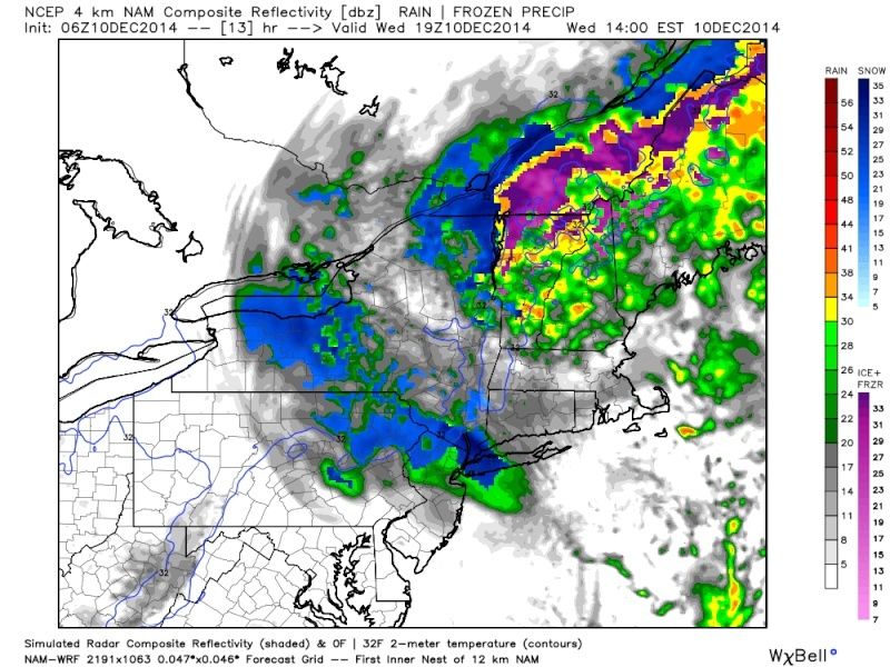
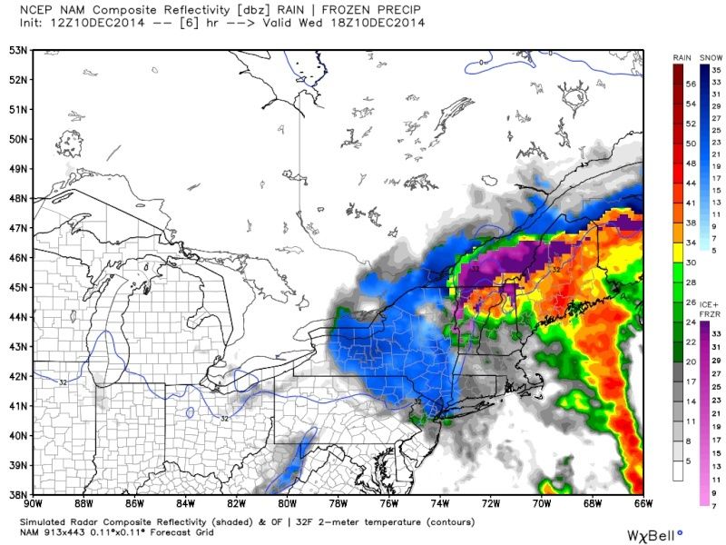
algae888 wrote:light rain 38*. precip starting to fill in around nyc metro. should be cold enough for snow by this afternoon. the question is how much moisture is available
Agreed Al. Latest Hi Res NAM shows a nice heavy band for W LI NYC the Lower HV and N NJ later this eve as the 850mb LP intensifies and the 850 temps tank. You and Jamn look to be in a great spotif that verifies. All eyes on the radar because these convective bands will pop up in only a few hrs notice
[img]
 [/img]
_________________
"In weather and in life, there's no winning and losing; there's only winning and learning."
WINTER 2012/2013 TOTALS 43.65"WINTER 2017/2018 TOTALS 62.85" WINTER 2022/2023 TOTALS 4.9"
WINTER 2013/2014 TOTALS 64.85"WINTER 2018/2019 TOTALS 14.25" WINTER 2023/2024 TOTALS 13.1"
WINTER 2014/2015 TOTALS 71.20"WINTER 2019/2020 TOTALS 6.35"
WINTER 2015/2016 TOTALS 35.00"WINTER 2020/2021 TOTALS 37.75"
WINTER 2016/2017 TOTALS 42.25"WINTER 2021/2022 TOTALS 31.65"

sroc4- Admin
- Posts : 8331
Reputation : 301
Join date : 2013-01-07
Location : Wading River, LI
Re: 12/9-12/10 Coastal Storm Observations
![]() by CPcantmeasuresnow Wed Dec 10, 2014 8:31 am
by CPcantmeasuresnow Wed Dec 10, 2014 8:31 am
Yesterday was just freezing rain in the am and on and off light rain the rest of the day. No accumulations of snow. It just changed in the last hour. Unfortunately I'm off to Brroklyn now and most likely won't see snow the rest of the day.

CPcantmeasuresnow- Wx Statistician Guru

- Posts : 7274
Reputation : 230
Join date : 2013-01-07
Age : 103
Location : Eastern Orange County, NY
Re: 12/9-12/10 Coastal Storm Observations
![]() by rb924119 Wed Dec 10, 2014 9:01 am
by rb924119 Wed Dec 10, 2014 9:01 am
https://drive.google.com/file/d/0Byod2Sk27yNYdE1mVDVRNjAxN2s/view?usp=sharing
rb924119- Meteorologist
- Posts : 6890
Reputation : 194
Join date : 2013-02-06
Age : 32
Location : Greentown, Pa
Re: 12/9-12/10 Coastal Storm Observations
![]() by jmanley32 Wed Dec 10, 2014 10:00 am
by jmanley32 Wed Dec 10, 2014 10:00 am
sroc4 wrote:algae888 wrote:light rain 38*. precip starting to fill in around nyc metro. should be cold enough for snow by this afternoon. the question is how much moisture is available
Agreed Al. Latest Hi Res NAM shows a nice heavy band for W LI NYC the Lower HV and N NJ later this eve as the 850mb LP intensifies and the 850 temps tank. You and Jamn look to be in a great spotif that verifies. All eyes on the radar because these convective bands will pop up in only a few hrs notice
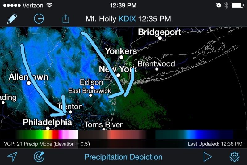
That's a sweet looking radar, very heavy area of snow. I may not drive to school if that comes around 5pm. We shall see how it is.

jmanley32- Senior Enthusiast

- Posts : 20517
Reputation : 108
Join date : 2013-12-12
Age : 42
Location : Yonkers, NY
Re: 12/9-12/10 Coastal Storm Observations
![]() by jmanley32 Wed Dec 10, 2014 10:02 am
by jmanley32 Wed Dec 10, 2014 10:02 am
jmanley32- Senior Enthusiast
- Posts : 20517
Reputation : 108
Join date : 2013-12-12
Age : 42
Location : Yonkers, NY
Re: 12/9-12/10 Coastal Storm Observations
![]() by jmanley32 Wed Dec 10, 2014 10:19 am
by jmanley32 Wed Dec 10, 2014 10:19 am
jmanley32- Senior Enthusiast
- Posts : 20517
Reputation : 108
Join date : 2013-12-12
Age : 42
Location : Yonkers, NY

jmanley32- Senior Enthusiast
- Posts : 20517
Reputation : 108
Join date : 2013-12-12
Age : 42
Location : Yonkers, NY
Re: 12/9-12/10 Coastal Storm Observations
![]() by mako460 Wed Dec 10, 2014 11:53 am
by mako460 Wed Dec 10, 2014 11:53 am
mako460- Pro Enthusiast

- Posts : 346
Reputation : 4
Join date : 2013-01-09
Age : 57
Location : Gerritsen Beach Brooklyn
Re: 12/9-12/10 Coastal Storm Observations
![]() by sroc4 Wed Dec 10, 2014 12:25 pm
by sroc4 Wed Dec 10, 2014 12:25 pm
mako460 wrote:38* and a cold drizzle here. it has picked up in intensity in the last half hour or so but i dont think anything is going to come out of it snow wise.
I think as the day progresses we will start to see change over esp if the precip gets heavy. Look at how cold the current 850mb temps are. The center of the 850mb LP is nearly stationary, and the 700mb and 500mb LP centers look like they are trying to vertically stack. That is why we are seeing the 850's crash. This system is now manufacturing its own cold air in the mid layers.
850mb

700mb:

500mb

With the 850's crashing and the LP centers stacking the atmosphere is going to remain very unstable. Look at the moisture fetch coming on shore in NE. Notice the precip shield is trying to fill in over western NY and CT and the whole thing is rotating counter clockwise around the axis which seems centered just east of LI. As that moisture fetch comes into the colder air to on the western side of the circulation expect convective banding to develop. Today and tonight could get real intersting for some. Keep watching that radar.

_________________
"In weather and in life, there's no winning and losing; there's only winning and learning."
WINTER 2012/2013 TOTALS 43.65"WINTER 2017/2018 TOTALS 62.85" WINTER 2022/2023 TOTALS 4.9"
WINTER 2013/2014 TOTALS 64.85"WINTER 2018/2019 TOTALS 14.25" WINTER 2023/2024 TOTALS 13.1"
WINTER 2014/2015 TOTALS 71.20"WINTER 2019/2020 TOTALS 6.35"
WINTER 2015/2016 TOTALS 35.00"WINTER 2020/2021 TOTALS 37.75"
WINTER 2016/2017 TOTALS 42.25"WINTER 2021/2022 TOTALS 31.65"
sroc4- Admin
- Posts : 8331
Reputation : 301
Join date : 2013-01-07
Location : Wading River, LI
Re: 12/9-12/10 Coastal Storm Observations
![]() by jmanley32 Wed Dec 10, 2014 12:29 pm
by jmanley32 Wed Dec 10, 2014 12:29 pm
jmanley32- Senior Enthusiast
- Posts : 20517
Reputation : 108
Join date : 2013-12-12
Age : 42
Location : Yonkers, NY
Re: 12/9-12/10 Coastal Storm Observations
![]() by NjWeatherGuy Wed Dec 10, 2014 12:44 pm
by NjWeatherGuy Wed Dec 10, 2014 12:44 pm

NjWeatherGuy- Advanced Forecaster
- Posts : 4100
Reputation : 28
Join date : 2013-01-06
Location : Belle Mead, NJ
Re: 12/9-12/10 Coastal Storm Observations
![]() by sroc4 Wed Dec 10, 2014 12:47 pm
by sroc4 Wed Dec 10, 2014 12:47 pm
 " />
" />_________________
"In weather and in life, there's no winning and losing; there's only winning and learning."
WINTER 2012/2013 TOTALS 43.65"WINTER 2017/2018 TOTALS 62.85" WINTER 2022/2023 TOTALS 4.9"
WINTER 2013/2014 TOTALS 64.85"WINTER 2018/2019 TOTALS 14.25" WINTER 2023/2024 TOTALS 13.1"
WINTER 2014/2015 TOTALS 71.20"WINTER 2019/2020 TOTALS 6.35"
WINTER 2015/2016 TOTALS 35.00"WINTER 2020/2021 TOTALS 37.75"
WINTER 2016/2017 TOTALS 42.25"WINTER 2021/2022 TOTALS 31.65"
sroc4- Admin
- Posts : 8331
Reputation : 301
Join date : 2013-01-07
Location : Wading River, LI
Re: 12/9-12/10 Coastal Storm Observations
![]() by Quietace Wed Dec 10, 2014 12:49 pm
by Quietace Wed Dec 10, 2014 12:49 pm
Been to busy to look at the radar all day and I'm presentlly surprised haha. 41 now but 925 and 850s are so cold it shouldn't be a problem as you mentionedsroc4 wrote:Skins and Ace you should get in on this as well. Boundary layers are still mid- upper 30's but dynamics in heavier bands should have no prob overcoming all the way to the coast.
Last edited by Quietace on Wed Dec 10, 2014 12:50 pm; edited 1 time in total

Quietace- Meteorologist - Mod

- Posts : 3687
Reputation : 33
Join date : 2013-01-07
Age : 27
Location : Point Pleasant, NJ
Re: 12/9-12/10 Coastal Storm Observations
![]() by jmanley32 Wed Dec 10, 2014 12:50 pm
by jmanley32 Wed Dec 10, 2014 12:50 pm
jmanley32- Senior Enthusiast
- Posts : 20517
Reputation : 108
Join date : 2013-12-12
Age : 42
Location : Yonkers, NY
Re: 12/9-12/10 Coastal Storm Observations
![]() by jmanley32 Wed Dec 10, 2014 12:52 pm
by jmanley32 Wed Dec 10, 2014 12:52 pm
jmanley32- Senior Enthusiast
- Posts : 20517
Reputation : 108
Join date : 2013-12-12
Age : 42
Location : Yonkers, NY
Re: 12/9-12/10 Coastal Storm Observations
![]() by jmanley32 Wed Dec 10, 2014 1:01 pm
by jmanley32 Wed Dec 10, 2014 1:01 pm
jmanley32- Senior Enthusiast
- Posts : 20517
Reputation : 108
Join date : 2013-12-12
Age : 42
Location : Yonkers, NY
Re: 12/9-12/10 Coastal Storm Observations
![]() by Aiosamoney21 Wed Dec 10, 2014 1:19 pm
by Aiosamoney21 Wed Dec 10, 2014 1:19 pm
Aiosamoney21- Posts : 86
Reputation : 1
Join date : 2014-02-09
Age : 32
Location : Norwood NJ
Re: 12/9-12/10 Coastal Storm Observations
![]() by Frank_Wx Wed Dec 10, 2014 1:20 pm
by Frank_Wx Wed Dec 10, 2014 1:20 pm
Aiosamoney21 wrote:Snow flurries here in norwood nj now
Where is Norwood?
_________________
_______________________________________________________________________________________________________
CLICK HERE to view NJ Strong Snowstorm Classifications
Frank_Wx- Godzilla Seeker
- Posts : 21305
Reputation : 328
Join date : 2013-01-05
Age : 31
Location : Jersey City, NJ -
Re: 12/9-12/10 Coastal Storm Observations
![]() by jmanley32 Wed Dec 10, 2014 1:22 pm
by jmanley32 Wed Dec 10, 2014 1:22 pm
jmanley32- Senior Enthusiast
- Posts : 20517
Reputation : 108
Join date : 2013-12-12
Age : 42
Location : Yonkers, NY
Re: 12/9-12/10 Coastal Storm Observations
![]() by Guest Wed Dec 10, 2014 1:23 pm
by Guest Wed Dec 10, 2014 1:23 pm
Guest- Guest
Re: 12/9-12/10 Coastal Storm Observations
![]() by jmanley32 Wed Dec 10, 2014 1:25 pm
by jmanley32 Wed Dec 10, 2014 1:25 pm
jmanley32- Senior Enthusiast
- Posts : 20517
Reputation : 108
Join date : 2013-12-12
Age : 42
Location : Yonkers, NY
Re: 12/9-12/10 Coastal Storm Observations
![]() by Aiosamoney21 Wed Dec 10, 2014 1:27 pm
by Aiosamoney21 Wed Dec 10, 2014 1:27 pm
Aiosamoney21- Posts : 86
Reputation : 1
Join date : 2014-02-09
Age : 32
Location : Norwood NJ
Re: 12/9-12/10 Coastal Storm Observations
![]() by Frank_Wx Wed Dec 10, 2014 1:38 pm
by Frank_Wx Wed Dec 10, 2014 1:38 pm
jmanley32 wrote:Frank it looks like the big band to the west is filling in and could rotate through giving a lot of people a heavier time of some snow for a decent amount of time, what do you think?
This is an impressive band for sure
Again, not much in accumulation unless you live in the areas I have in the scroll...but nice to see nonetheless
_________________
_______________________________________________________________________________________________________
CLICK HERE to view NJ Strong Snowstorm Classifications
Frank_Wx- Godzilla Seeker
- Posts : 21305
Reputation : 328
Join date : 2013-01-05
Age : 31
Location : Jersey City, NJ -
Page 7 of 10 • 1, 2, 3, 4, 5, 6, 7, 8, 9, 10 ![]()
|
|
|