
 Search
General Weather Discussions/Observations
Page 4 of 4 •  1, 2, 3, 4

Snow88- Senior Enthusiast

- Posts : 2193
Join date : 2013-01-09
Re: General Weather Discussions/Observations
![]() by Dunnzoo Thu Jan 24, 2013 7:56 pm
by Dunnzoo Thu Jan 24, 2013 7:56 pm
Dunnzoo- Senior Enthusiast - Mod

- Posts : 4891
Join date : 2013-01-11
Re: General Weather Discussions/Observations
![]() by NjWeatherGuy Thu Jan 24, 2013 8:29 pm
by NjWeatherGuy Thu Jan 24, 2013 8:29 pm

NjWeatherGuy- Advanced Forecaster

- Posts : 4100
Reputation : 28
Join date : 2013-01-06
Location : Belle Mead, NJ
Re: General Weather Discussions/Observations
![]() by Frank_Wx Thu Jan 24, 2013 9:08 pm
by Frank_Wx Thu Jan 24, 2013 9:08 pm
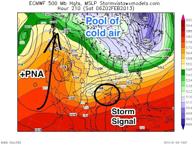
I'm pretty much done tracking tomorrows system. A general coating to 2 inches is probably with southern areas getting patches of 3 inch amounts. Furthest south you live, more snow you'll get.
Next week, GFS OP is on its own with the train of cutters idea. The ensembles disagree, in fact stay cold through most of their run. The GGEM and EURO also look different.
Below is the 12z EURO 500mb map. A nice ridge develops in the west and there is a trough over the northeast. Notice how the cold is not as intense as it is this week. The PV is displaced further northwest but there is an area of High Pressure over the GL.
There is also...a storm signal.
What comes out of it remains to be seen. I definitely do not think it will cut given the western ridge, MJO propagation, and pool of arctic air dug into south-central and eastern Canada. Do NOT look at the GFS OP. Terrible model. Look at ensembles and non-American models.

Frank_Wx- Godzilla Seeker

- Posts : 21305
Reputation : 328
Join date : 2013-01-05
Age : 31
Location : Jersey City, NJ -

Re: General Weather Discussions/Observations
![]() by Frank_Wx Sat Jan 26, 2013 9:19 am
by Frank_Wx Sat Jan 26, 2013 9:19 am
Frank_Wx- Godzilla Seeker
- Posts : 21305
Reputation : 328
Join date : 2013-01-05
Age : 31
Location : Jersey City, NJ -
Re: General Weather Discussions/Observations
![]() by amugs Sat Jan 26, 2013 1:31 pm
by amugs Sat Jan 26, 2013 1:31 pm

amugs- Advanced Forecaster - Mod
- Posts : 15093
Reputation : 213
Join date : 2013-01-07
Age : 54
Location : Hillsdale,NJ
January 30th Severe Weather Day
![]() by Frank_Wx Sun Jan 27, 2013 9:24 pm
by Frank_Wx Sun Jan 27, 2013 9:24 pm
Gulf moisture interacting with a strong cold front. Ahead of the cold front mild temps, behind it arctic air. The interaction = Boom and severe weather will occur. This could get interesting...
Frank_Wx- Godzilla Seeker
- Posts : 21305
Reputation : 328
Join date : 2013-01-05
Age : 31
Location : Jersey City, NJ -
Re: General Weather Discussions/Observations
![]() by amugs Sun Jan 27, 2013 9:51 pm
by amugs Sun Jan 27, 2013 9:51 pm
amugs- Advanced Forecaster - Mod
- Posts : 15093
Reputation : 213
Join date : 2013-01-07
Age : 54
Location : Hillsdale,NJ
Re: General Weather Discussions/Observations
![]() by Frank_Wx Sun Jan 27, 2013 10:15 pm
by Frank_Wx Sun Jan 27, 2013 10:15 pm
amugs wrote:Frank, looking at a couple of maps it is showing the possibility of some back end snow (showers and maybe even a squall) from this system. Also read that this cold to fiollow late week (weekend) will be more entrenched and last into mid feb - I hope they are right. Do you see the same?
There will not be backend snow. Maybe in interior sections, but we will just see thunderstorms and rain. By the time the cold air arrives, the precip will be gone. As for the upcoming cold blast, it's going to last longer than the last one BUT it will not be as harsh. I'm thinking it starts in the mid 20's but moderates to more seasonal temps by the middle of next week. The upcoming weekend though definitely looks cold.
Frank_Wx- Godzilla Seeker
- Posts : 21305
Reputation : 328
Join date : 2013-01-05
Age : 31
Location : Jersey City, NJ -
Re: General Weather Discussions/Observations
![]() by Frank_Wx Mon Jan 28, 2013 10:03 am
by Frank_Wx Mon Jan 28, 2013 10:03 am
Frank_Wx- Godzilla Seeker
- Posts : 21305
Reputation : 328
Join date : 2013-01-05
Age : 31
Location : Jersey City, NJ -
Re: General Weather Discussions/Observations
![]() by NjWeatherGuy Mon Jan 28, 2013 4:05 pm
by NjWeatherGuy Mon Jan 28, 2013 4:05 pm
NjWeatherGuy- Advanced Forecaster
- Posts : 4100
Reputation : 28
Join date : 2013-01-06
Location : Belle Mead, NJ
Re: General Weather Discussions/Observations
![]() by Frank_Wx Mon Jan 28, 2013 11:19 pm
by Frank_Wx Mon Jan 28, 2013 11:19 pm
Frank_Wx- Godzilla Seeker
- Posts : 21305
Reputation : 328
Join date : 2013-01-05
Age : 31
Location : Jersey City, NJ -
Re: General Weather Discussions/Observations
![]() by Radz Tue Jan 29, 2013 6:58 am
by Radz Tue Jan 29, 2013 6:58 am

Radz- Pro Enthusiast

- Posts : 1028
Reputation : 17
Join date : 2013-01-12
Location : Cortlandt Manor NY
Re: General Weather Discussions/Observations
![]() by Frank_Wx Tue Jan 29, 2013 8:06 am
by Frank_Wx Tue Jan 29, 2013 8:06 am
Frank_Wx- Godzilla Seeker
- Posts : 21305
Reputation : 328
Join date : 2013-01-05
Age : 31
Location : Jersey City, NJ -
Re: General Weather Discussions/Observations
![]() by Frank_Wx Tue Jan 29, 2013 11:15 pm
by Frank_Wx Tue Jan 29, 2013 11:15 pm
Frank_Wx- Godzilla Seeker
- Posts : 21305
Reputation : 328
Join date : 2013-01-05
Age : 31
Location : Jersey City, NJ -
Re: General Weather Discussions/Observations
![]() by Frank_Wx Wed Jan 30, 2013 7:57 am
by Frank_Wx Wed Jan 30, 2013 7:57 am
Frank_Wx- Godzilla Seeker
- Posts : 21305
Reputation : 328
Join date : 2013-01-05
Age : 31
Location : Jersey City, NJ -
Re: General Weather Discussions/Observations
![]() by Frank_Wx Wed Jan 30, 2013 11:28 pm
by Frank_Wx Wed Jan 30, 2013 11:28 pm
Frank_Wx- Godzilla Seeker
- Posts : 21305
Reputation : 328
Join date : 2013-01-05
Age : 31
Location : Jersey City, NJ -
Re: General Weather Discussions/Observations
![]() by sroc4 Fri Feb 01, 2013 7:43 am
by sroc4 Fri Feb 01, 2013 7:43 am
The PNA in the west has been positive and a ridge has been there but the timing of the northern energy trying to dig in has been off. Meaning that as the northern energy digs in the PNA breaks down some such that it cannot really dig as it drops into the western great lakes region. At that location because the ridge in the west is not steep enough to over come the progressive flow along the east coast so the northern energy begins its trek west to east as it enters the CONUS instead of diving in a little more south and east to trigger an earlier interaction (phase) with the southern energy. The western ridge has not been strong enough to overcome the progressive flow along the east coast.
I will leave you with this. This winter along the east coast has been not much more than 100-200miles from a a potential epic winter. If the northern energy were allowed to dig in 100-200 miles more south and east, or if the southern energy where to start its more north to northeast turn 100-200 miles further west there would be waaaaaayy more precip that would have affected the NE states. All in all this winter has been great....for the fish who live OTS to our east. It has been very active all season and it really has been nothing more than a near miss all season. Hopefully we can connect at least once this season. We shall see.
https://2img.net/r/ihimizer/img41/4456/soclosex.png
_________________
"In weather and in life, there's no winning and losing; there's only winning and learning."
WINTER 2012/2013 TOTALS 43.65"WINTER 2017/2018 TOTALS 62.85" WINTER 2022/2023 TOTALS 4.9"
WINTER 2013/2014 TOTALS 64.85"WINTER 2018/2019 TOTALS 14.25" WINTER 2023/2024 TOTALS 13.1"
WINTER 2014/2015 TOTALS 71.20"WINTER 2019/2020 TOTALS 6.35"
WINTER 2015/2016 TOTALS 35.00"WINTER 2020/2021 TOTALS 37.75"
WINTER 2016/2017 TOTALS 42.25"WINTER 2021/2022 TOTALS 31.65"

sroc4- Admin
- Posts : 8331
Reputation : 301
Join date : 2013-01-07
Location : Wading River, LI
Re: General Weather Discussions/Observations
![]() by amugs Fri Feb 01, 2013 1:04 pm
by amugs Fri Feb 01, 2013 1:04 pm
amugs- Advanced Forecaster - Mod
- Posts : 15093
Reputation : 213
Join date : 2013-01-07
Age : 54
Location : Hillsdale,NJ
Re: General Weather Discussions/Observations
![]() by Radz Sat Feb 02, 2013 9:48 am
by Radz Sat Feb 02, 2013 9:48 am
Radz- Pro Enthusiast
- Posts : 1028
Reputation : 17
Join date : 2013-01-12
Location : Cortlandt Manor NY
Radz- Pro Enthusiast
- Posts : 1028
Reputation : 17
Join date : 2013-01-12
Location : Cortlandt Manor NY
Re: General Weather Discussions/Observations
![]() by Frank_Wx Sun Feb 03, 2013 10:07 pm
by Frank_Wx Sun Feb 03, 2013 10:07 pm
Here is Monday night...

Frank_Wx- Godzilla Seeker
- Posts : 21305
Reputation : 328
Join date : 2013-01-05
Age : 31
Location : Jersey City, NJ -
Re: General Weather Discussions/Observations
![]() by Frank_Wx Mon Feb 04, 2013 1:57 pm
by Frank_Wx Mon Feb 04, 2013 1:57 pm

Clipper tonight will bring some snow showers. Coating to an inch possible.
Frank_Wx- Godzilla Seeker
- Posts : 21305
Reputation : 328
Join date : 2013-01-05
Age : 31
Location : Jersey City, NJ -
Re: General Weather Discussions/Observations
![]() by aiannone Mon Feb 04, 2013 7:21 pm
by aiannone Mon Feb 04, 2013 7:21 pm
http://www.wildaboutweather.com/alex-iannone.html
_________________
-Alex Iannone-

aiannone- Senior Enthusiast - Mod
- Posts : 4813
Reputation : 92
Join date : 2013-01-07
Location : Saint James, LI (Northwest Suffolk Co.)
Re: General Weather Discussions/Observations
![]() by Frank_Wx Mon Feb 04, 2013 8:07 pm
by Frank_Wx Mon Feb 04, 2013 8:07 pm
Mets2695 wrote:My map that I created for Tonight's clipper for the facebook page Wild About Weather that I post for
http://www.wildaboutweather.com/alex-iannone.html
Nice! I agree
Frank_Wx- Godzilla Seeker
- Posts : 21305
Reputation : 328
Join date : 2013-01-05
Age : 31
Location : Jersey City, NJ -
Re: General Weather Discussions/Observations
![]() by SNOW MAN Thu Feb 07, 2013 1:36 pm
by SNOW MAN Thu Feb 07, 2013 1:36 pm

SNOW MAN- Senior Enthusiast
- Posts : 1361
Reputation : 25
Join date : 2013-01-13
Age : 64
Location : Marshalls Creek Pa.
Page 4 of 4 • 1, 2, 3, 4
|
|
|