
 Search
Record Cold & Dangerous Wind Chills Sunday-Monday
Page 1 of 8 • 1, 2, 3, 4, 5, 6, 7, 8 ![]()

Record Cold & Dangerous Wind Chills Sunday-Monday
![]() by Frank_Wx Thu Feb 12, 2015 10:40 am
by Frank_Wx Thu Feb 12, 2015 10:40 am
A HIGH IMPACT WEATHER EVENT WITH RESPECT TO WIND CHILL
ADVISORY/WARNING LEVEL COLD AND STRONG, POSSIBLY HIGH WIND IS STILL
ON OR CLOSE TO SCHEDULE FOR LATE SATURDAY NIGHT INTO SUNDAY NIGHT.
NOT MUCH BETTER ON AREA WATERS WITH POSSIBLE STORM FORCE WIND GUSTS,
MODERATE TO HEAVY FREEZING SPRAY AND MAYBE BLOWOUT TIDES.
THE MOST UNCERTAIN ELEMENT IS THE AMOUNT OF SNOW THAT WILL FALL
DURING THIS PERIOD. THE TRIGGERING CLOSED LOW HAS JUST ENTERED
CANADA AND WILL INITIATE RAPID INTENSIFICATION AS IT PASSES OUR
CWA. THE ATTENDANT DEEPENING LOW WILL FORM A NORLUN TROF WHICH WILL
BE A CONCENTRATED BAND OF HEAVIER SNOW. THIS FEATURE DEPENDS ON THE
EXACT PATH OF THE CLOSED AND SURFACE LOW. THE 00Z MODEL RUN SUITE
HAS SHIFTED NORTHEAST WITH THIS FEATURE TO EITHER NEW ENGLAND OR
LONG ISLAND/NYC. GIVEN HOW DIFFICULT ITS BEEN TO FORECAST SNOW THIS
WINTER WITH THE NEVER ENDING PARADE OF MILLER B LOWS, ITS TOO EARLY
TO KNOW FOR SURE THAT WARNING CRITERIA SNOW WILL NOT OCCUR IN OUR
AREA. OUR PRELIMINARY THOUGHTS HAVE 1-2" SOUTH OF THE PA
TURNPIKE/I195 CORRIDOR AND 2-5" NORTH OF THESE CORRIDORS.
THERE IS ANOTHER MOISTURE RICHER CONVENTIONAL LOW PREDICTED TO BRING
MORE PRECIPITATION INTO OUR REGION TUESDAY INTO WEDNESDAY. IT WILL
BE COLD ENOUGH FOR SNOW AT THE START. THE MODELS ARE PREDICTING A
CHANGE TO NON-SNOW IN THE SOUTHEAST PART OF OUR CWA, BUT THIS IS TOO
FAR IN THE FUTURE TO KNOW FOR SURE IF OR HOW THIS WILL EVOLVE.
FRIDAY...AFTER A VERY COLD START, CONDITIONS WILL RELATIVELY IMPROVE
AS THE DAY PROGRESSES. WINDS SHOULD SLOWLY DIMINISH. SKIES SHOULD
START MOSTLY SUNNY WITH SOME HIGH LEVEL CLOUDINESS ARRIVING DURING
THE AFTERNOON, ESPECIALLY NORTHWEST. CONTINUING THE RUNNING THEME
(UNTIL IT PROVES US WRONG) THAT STAT GUIDANCE WILL BE TOO LOW WITH
MAX TEMPS, WE WENT A FEW DEGREES ABOVE THEM.
FRIDAY NIGHT...INCREASING SOUTHWEST FLOW AND CLOUDS SHOULD HOLD
TEMPERATURES UP. IN FACT, THEY MAY RISE TOWARD MORNING. THIS GETS
TRICKY BECAUSE OF SNOW COVER NORTH AND CLOUD THICKNESS, SO HERE WE
STAYED CLOSER TO HOURLY STAT GUIDANCE.
ON SATURDAY, THE SOUTHWESTERLY FLOW PRECEDING THE COLD FRONT HAS
SHOWN A TREND AT WARMING THE COASTAL PLAIN FURTHER. IN FACT
PREDICTED 925MB TEMPS ARE NOW CREEPING ABOVE 0C. IN REALITY THIS IS
A BRIEF RESPITE TO THE ARCTIC AIR BEHIND THE COLD FRONT. LIKELY
POPS IN SNOW ARE BROUGHT TO THE I95 CORRIDOR BY THE END OF THE
AFTERNOON. ONE TO TWO INCHES EXPECTED BY NIGHTFALL ONCE WE GET
INTO NORTHERN NJ AS WELL AS FROM THE POCONOS TO THE FAR NORTHERN
PHL SUBURBS.
THEN ON SATURDAY EVENING, THERE IS THE POTENTIAL FOR A HEAVY SNOW
BURST, AS AN AXIS OF INSTABILITY MOVES ACROSS OUR REGION. MODELS
BRING PREDICTED TOTAL TOTALS TO 45-55 AND INDICATE SLANTWISE (AT
SEVERAL LEVELS) CONVECTION. THERE IS PREDICTED OMEGA IN THE SNOW
GROWTH REGION, MORE SO NORTH THAN SOUTH. THIS DOES NOT INCLUDE
ANY NORLUN TROF FORMATION WHICH WOULD PROLONG THE SNOW. THERE ARE
STILL MANY UNCERTAINTIES, BUT GIVEN THE CONVECTIVE POTENTIAL,
DECENT SNOW RATIOS AND THE TRIED BUT TRUE EXPRESSION THAT THERE IS
ALWAYS A SURPRISE UNDER A CLOSED LOW. WE WERE BULLISH BEYOND THE
MODEL PREDICTED QPF WITH THE SNOW.
RIGHT NOW THE HEAVIER SNOW IS PREDICTED TO PRECEDE THE INCREASING
WINDS WHICH SHOULD START CRANKING TOWARD MORNING. THE PRESSURE
DIFFERENCE BETWEEN THE BOOMING LOW AND ARCTIC HIGH IS ABOUT 20 MB
TIGHTER THAN TONIGHT'S NEAR ADVISORY WIND EVENT. GIVEN A STATUS
QUO IN MODELING PROJECTIONS, WE WOULD EASILY GET INTO WIND
ADVISORY CRITERIA AND POSSIBLY REACH HIGH WIND CRITERIA,
ESPECIALLY IN DELMARVA AND CLOSER TO THE COAST. COUPLED WITH MIN
TEMPERATURES GETTING INTO OR CLOSE TO THE SINGLE NUMBERS BY SUNDAY
MORNING AND SUB ZERO WIND CHILLS, ITS NOT A WELCOME COMBINATION FOR
POWER OUTAGES.
SOME RESIDUAL SNOW SHOWERS ARE POSSIBLE NORTH ON SUNDAY. OTHERWISE,
THE MAIN IMPACT WILL CONTINUE TO BE THE STRONG WINDS, AND VERY
UNSEASONABLY COLD TEMPERATURES. THE HIGHEST WINDS FOR THIS EVENT
SHOULD LIKELY OCCUR BY THE CONCLUSION OF SUNDAY MORNING WITH ONLY
SLOW IMPROVEMENT SUNDAY AFTERNOON AND NIGHT.
SUNDAY NIGHT/MONDAY MORNING WE WILL BE RIVALING RECORD LOWS FOR
THE DAY. WINDS WILL STILL BE A FACTOR WITH WIND CHILL
ADVISORY/WARNING LEVELS POSSIBLY REACHED. AIR MASS MODIFICATION
WILL THEN START MONDAY AFTERNOON AND CONTINUE MONDAY NIGHT.
WE DID NOT MAKE TOO MANY CHANGES TO TUESDAY AND WEDNESDAY. WE STAYED
CLOSE TO WPC GUIDANCE, TOO MUCH UNCERTAINTY WITH BEYOND DAY 5
SYSTEMS THIS WINTER TO DIVERT MUCH FROM CONTINUITY OR CLIMATOLOGY.
Usually, cold is always over-done in the long range. So I might add at least 5 degrees to these temps you see on the models, but I will keep track of it anyway because I think it's impressive. Maybe some of you stats guys can bless us with some interesting tidbits.
Temps. Sunday afternoon

Temps. Monday morning

Wind chills 1pm Sunday (high temps are in the low teens or upper single digits)

Wind chills 7am Monday


_________________
_______________________________________________________________________________________________________
CLICK HERE to view NJ Strong Snowstorm Classifications

Frank_Wx- Godzilla Seeker

- Posts : 21305
Reputation : 328
Join date : 2013-01-05
Age : 31
Location : Jersey City, NJ -

Re: Record Cold & Dangerous Wind Chills Sunday-Monday
![]() by jmanley32 Thu Feb 12, 2015 10:43 am
by jmanley32 Thu Feb 12, 2015 10:43 am
WITH LOWS SUNDAY NIGHT APPROACHING
ZERO IN THE NYC METRO AND IN THE SINGLE DIGITS BELOW ZERO MOST
EVERYWHERE ELSE. TO PUT THE RARITY OF THIS COLD AIR IN
PERSPECTIVE...TEMPS HAVE NOT DROPPED TO ZERO IN NYC IN OVER 20
YEARS...SINCE JANUARY 27 1994! THAT MONTH WAS ALSO THE LAST TIME NYC
DROPPED BELOW ZERO...ON JANUARY 19TH OF 1994 TO -2. THE LAST TIME
NYC DROPPED TO 1 DEGREE WAS JANUARY 10TH AND 16TH OF 2004...OVER 11
YEARS AGO.

jmanley32- Senior Enthusiast

- Posts : 20517
Reputation : 108
Join date : 2013-12-12
Age : 42
Location : Yonkers, NY
Re: Record Cold & Dangerous Wind Chills Sunday-Monday
![]() by jmanley32 Thu Feb 12, 2015 10:45 am
by jmanley32 Thu Feb 12, 2015 10:45 am
jmanley32- Senior Enthusiast
- Posts : 20517
Reputation : 108
Join date : 2013-12-12
Age : 42
Location : Yonkers, NY
Re: Record Cold & Dangerous Wind Chills Sunday-Monday
![]() by Frank_Wx Thu Feb 12, 2015 10:49 am
by Frank_Wx Thu Feb 12, 2015 10:49 am
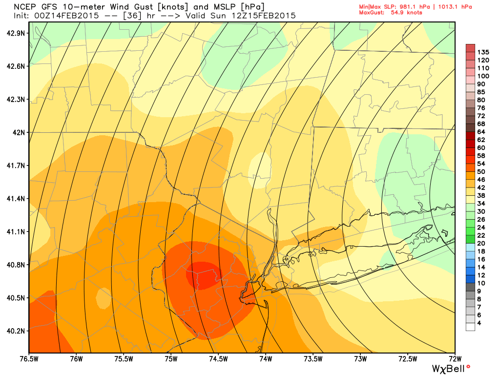
Pressure gradients being closely compacted will result in high winds gusts along the coast. The backside of this incredible trough we'll see on Saturday night (same system that could give us snow) is bringing down with it temps. we usually see in the North Pole.
By Sunday afternoon, we should see wind gusts in excess of 40-50 mph for those west and north of NYC, and 50-60mph for NYC and points east onto LI. I would not be surprised if there was a wind gust of 70+ mph on the east end

**REMEMBER** WIND CHILLS ARE GOING TO BE WELL BELOW 0 SO THESE HIGH WIND GUSTS ARE GOING TO MAKE OUR DAY ON SUNDAY FEEL LIKE IT'S BETWEEN -10*F TO -20*F***
_________________
_______________________________________________________________________________________________________
CLICK HERE to view NJ Strong Snowstorm Classifications
Frank_Wx- Godzilla Seeker
- Posts : 21305
Reputation : 328
Join date : 2013-01-05
Age : 31
Location : Jersey City, NJ -
Re: Record Cold & Dangerous Wind Chills Sunday-Monday
![]() by RJB8525 Thu Feb 12, 2015 12:10 pm
by RJB8525 Thu Feb 12, 2015 12:10 pm

RJB8525- Senior Enthusiast
- Posts : 1994
Reputation : 28
Join date : 2013-02-06
Age : 38
Location : Hackettstown, NJ
Re: Record Cold & Dangerous Wind Chills Sunday-Monday
![]() by docstox12 Thu Feb 12, 2015 12:12 pm
by docstox12 Thu Feb 12, 2015 12:12 pm
Frank_Wx wrote:I forgot to talk about the winds, whoops!
Pressure gradients being closely compacted will result in high winds gusts along the coast. The backside of this incredible trough we'll see on Saturday night (same system that could give us snow) is bringing down with it temps. we usually see in the North Pole.
By Sunday afternoon, we should see wind gusts in excess of 40-50 mph for those west and north of NYC, and 50-60mph for NYC and points east onto LI. I would not be surprised if there was a wind gust of 70+ mph on the east end
**REMEMBER** WIND CHILLS ARE GOING TO BE WELL BELOW 0 SO THESE HIGH WIND GUSTS ARE GOING TO MAKE OUR DAY ON SUNDAY FEEL LIKE IT'S BETWEEN -10*F TO -20*F***
Batten down the hatches, Nofo.Please be careful out there,buddy!!!

docstox12- Wx Statistician Guru

- Posts : 8507
Reputation : 222
Join date : 2013-01-07
Age : 73
Location : Monroe NY
Re: Record Cold & Dangerous Wind Chills Sunday-Monday
![]() by Guest Thu Feb 12, 2015 12:21 pm
by Guest Thu Feb 12, 2015 12:21 pm
Guest- Guest
Re: Record Cold & Dangerous Wind Chills Sunday-Monday
![]() by jmanley32 Thu Feb 12, 2015 12:22 pm
by jmanley32 Thu Feb 12, 2015 12:22 pm
jmanley32- Senior Enthusiast
- Posts : 20517
Reputation : 108
Join date : 2013-12-12
Age : 42
Location : Yonkers, NY
Re: Record Cold & Dangerous Wind Chills Sunday-Monday
![]() by jmanley32 Thu Feb 12, 2015 12:23 pm
by jmanley32 Thu Feb 12, 2015 12:23 pm
syosnow94 wrote:Anyone on here loses power, find a way to PM me and come on over. Plenty of wood and the wood-burning stove that heats the entire house. Just BYOB!!
Anyone closer to me want to make same offer? I am most worried bout how cold our apartment would get and the baby, not overly worried but its somewhat of a concern. LI def, as they will likely see higher end but from here east I think it could happen anywhere.
jmanley32- Senior Enthusiast
- Posts : 20517
Reputation : 108
Join date : 2013-12-12
Age : 42
Location : Yonkers, NY
Re: Record Cold & Dangerous Wind Chills Sunday-Monday
![]() by jmanley32 Thu Feb 12, 2015 1:52 pm
by jmanley32 Thu Feb 12, 2015 1:52 pm
jmanley32- Senior Enthusiast
- Posts : 20517
Reputation : 108
Join date : 2013-12-12
Age : 42
Location : Yonkers, NY
Re: Record Cold & Dangerous Wind Chills Sunday-Monday
![]() by CPcantmeasuresnow Thu Feb 12, 2015 9:39 pm
by CPcantmeasuresnow Thu Feb 12, 2015 9:39 pm
The lows they have forecast for the HV, -5 or so, we have reached or exceeded this winter but on calm nights, again it's the winds that will be the big difference maker.

CPcantmeasuresnow- Wx Statistician Guru
- Posts : 7274
Reputation : 230
Join date : 2013-01-07
Age : 103
Location : Eastern Orange County, NY
Re: Record Cold & Dangerous Wind Chills Sunday-Monday
![]() by skinsfan1177 Thu Feb 12, 2015 10:09 pm
by skinsfan1177 Thu Feb 12, 2015 10:09 pm

skinsfan1177- Senior Enthusiast
- Posts : 4485
Reputation : 35
Join date : 2013-01-07
Age : 46
Location : Point Pleasant Boro
Re: Record Cold & Dangerous Wind Chills Sunday-Monday
![]() by amugs Thu Feb 12, 2015 10:13 pm
by amugs Thu Feb 12, 2015 10:13 pm
_________________
Mugs
AKA:King: Snow Weenie
Self Proclaimed
WINTER 2014-15 : 55.12" +.02 for 6 coatings (avg. 35")
WINTER 2015-16 Total - 29.8" (Avg 35")
WINTER 2016-17 : 39.5" so far

amugs- Advanced Forecaster - Mod

- Posts : 15093
Reputation : 213
Join date : 2013-01-07
Age : 54
Location : Hillsdale,NJ
Re: Record Cold & Dangerous Wind Chills Sunday-Monday
![]() by psv88 Thu Feb 12, 2015 10:17 pm
by psv88 Thu Feb 12, 2015 10:17 pm
Its begun.
psv88- Posts : 25
Reputation : 0
Join date : 2015-02-10
Location : Albertson, New York, Nassau County -
Re: Record Cold & Dangerous Wind Chills Sunday-Monday
![]() by Dunnzoo Thu Feb 12, 2015 10:20 pm
by Dunnzoo Thu Feb 12, 2015 10:20 pm
_________________
Janet
Snowfall winter of 2023-2024 17.5"
Snowfall winter of 2022-2023 6.0"
Snowfall winter of 2021-2022 17.6" 1" sleet 2/25/22
Snowfall winter of 2020-2021 51.1"
Snowfall winter of 2019-2020 8.5"
Snowfall winter of 2018-2019 25.1"
Snowfall winter of 2017-2018 51.9"
Snowfall winter of 2016-2017 45.6"
Snowfall winter of 2015-2016 29.5"
Snowfall winter of 2014-2015 50.55"
Snowfall winter of 2013-2014 66.5"

Dunnzoo- Senior Enthusiast - Mod
- Posts : 4892
Reputation : 68
Join date : 2013-01-11
Age : 62
Location : Westwood, NJ
Re: Record Cold & Dangerous Wind Chills Sunday-Monday
![]() by jmanley32 Thu Feb 12, 2015 10:45 pm
by jmanley32 Thu Feb 12, 2015 10:45 pm
jmanley32- Senior Enthusiast
- Posts : 20517
Reputation : 108
Join date : 2013-12-12
Age : 42
Location : Yonkers, NY
Re: Record Cold & Dangerous Wind Chills Sunday-Monday
![]() by jmanley32 Thu Feb 12, 2015 10:46 pm
by jmanley32 Thu Feb 12, 2015 10:46 pm
jmanley32- Senior Enthusiast
- Posts : 20517
Reputation : 108
Join date : 2013-12-12
Age : 42
Location : Yonkers, NY
Re: Record Cold & Dangerous Wind Chills Sunday-Monday
![]() by jmanley32 Thu Feb 12, 2015 11:05 pm
by jmanley32 Thu Feb 12, 2015 11:05 pm
jmanley32- Senior Enthusiast
- Posts : 20517
Reputation : 108
Join date : 2013-12-12
Age : 42
Location : Yonkers, NY
Re: Record Cold & Dangerous Wind Chills Sunday-Monday
![]() by weatherwatchermom Fri Feb 13, 2015 4:33 am
by weatherwatchermom Fri Feb 13, 2015 4:33 am
my therm 9.8 degrees
w/u real feel -10
w/u wind n 24 gusts 35
arrrrr.....
octupus kid in bed...dog closer to me due to octupus kid and o/k has cold so snoring too!!...husband jumps ship to spare bedroom....going to be a long weekend.!! fun watching weather...not so fun sleeping..lol

weatherwatchermom- Senior Enthusiast
- Posts : 3750
Reputation : 77
Join date : 2014-11-25
Age : 60
Location : Hazlet Township, NJ
Re: Record Cold & Dangerous Wind Chills Sunday-Monday
![]() by Frank_Wx Fri Feb 13, 2015 10:56 pm
by Frank_Wx Fri Feb 13, 2015 10:56 pm

_________________
_______________________________________________________________________________________________________
CLICK HERE to view NJ Strong Snowstorm Classifications
Frank_Wx- Godzilla Seeker
- Posts : 21305
Reputation : 328
Join date : 2013-01-05
Age : 31
Location : Jersey City, NJ -
Re: Record Cold & Dangerous Wind Chills Sunday-Monday
![]() by Frank_Wx Fri Feb 13, 2015 10:57 pm
by Frank_Wx Fri Feb 13, 2015 10:57 pm

Maybe gusts 35-45mph instead of 50+mph (except for immediate coast).
_________________
_______________________________________________________________________________________________________
CLICK HERE to view NJ Strong Snowstorm Classifications
Frank_Wx- Godzilla Seeker
- Posts : 21305
Reputation : 328
Join date : 2013-01-05
Age : 31
Location : Jersey City, NJ -
Re: Record Cold & Dangerous Wind Chills Sunday-Monday
![]() by Frank_Wx Fri Feb 13, 2015 10:58 pm
by Frank_Wx Fri Feb 13, 2015 10:58 pm
_________________
_______________________________________________________________________________________________________
CLICK HERE to view NJ Strong Snowstorm Classifications
Frank_Wx- Godzilla Seeker
- Posts : 21305
Reputation : 328
Join date : 2013-01-05
Age : 31
Location : Jersey City, NJ -
Re: Record Cold & Dangerous Wind Chills Sunday-Monday
![]() by Frank_Wx Fri Feb 13, 2015 10:59 pm
by Frank_Wx Fri Feb 13, 2015 10:59 pm
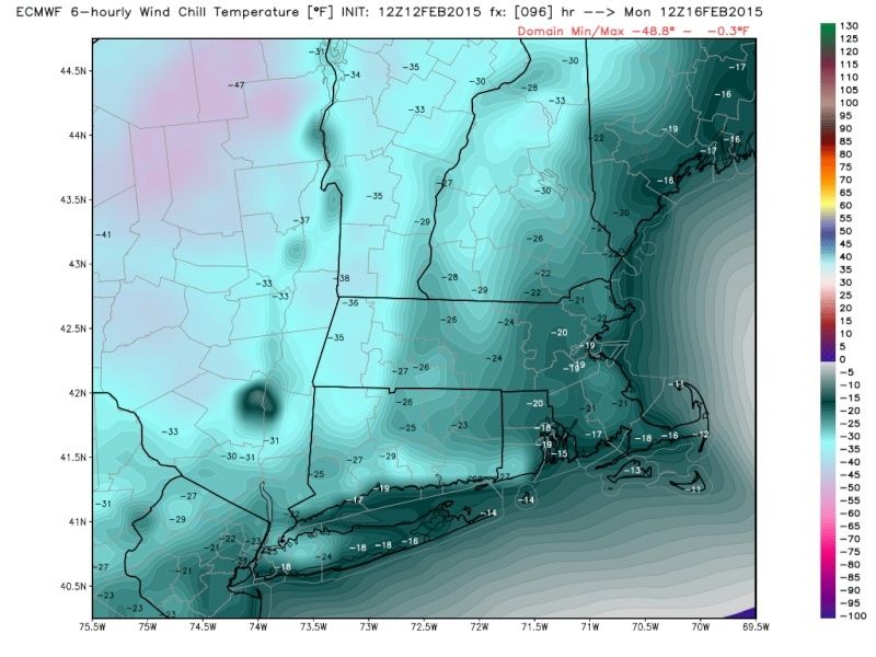
Sunday 1pm wind chills near -20*F

_________________
_______________________________________________________________________________________________________
CLICK HERE to view NJ Strong Snowstorm Classifications
Frank_Wx- Godzilla Seeker
- Posts : 21305
Reputation : 328
Join date : 2013-01-05
Age : 31
Location : Jersey City, NJ -
Re: Record Cold & Dangerous Wind Chills Sunday-Monday
![]() by elkiehound Sat Feb 14, 2015 7:21 am
by elkiehound Sat Feb 14, 2015 7:21 am

elkiehound- Posts : 56
Reputation : 1
Join date : 2013-12-09
Location : Ringoes NJ
Re: Record Cold & Dangerous Wind Chills Sunday-Monday
![]() by jmanley32 Sat Feb 14, 2015 9:44 am
by jmanley32 Sat Feb 14, 2015 9:44 am
jmanley32- Senior Enthusiast
- Posts : 20517
Reputation : 108
Join date : 2013-12-12
Age : 42
Location : Yonkers, NY
Page 1 of 8 • 1, 2, 3, 4, 5, 6, 7, 8 ![]()
|
|
|