
 Search
Long Range Thread 8.0
Page 27 of 40 •  1 ... 15 ... 26, 27, 28 ... 33 ... 40
 ![]()
Re: Long Range Thread 8.0
![]() by jmanley32 Fri Oct 23, 2015 11:24 am
by jmanley32 Fri Oct 23, 2015 11:24 am
Frank_Wx wrote:jmanley32 wrote:But he said halo ween storm looks to b mainly dry on Halloween if those runs hold timeframe. Of course I suppose this far out either could jump in one direction or other.
While the time frame I call out in the scroll includes Halloween, it does not mean it will rain on Halloween. The timing of both storms could be the 28th-29th and 1st-2nd. So Halloween could be salvaged. That is looking increasingly likely but still a decent time out for change to occur.
I figured Frank was just checking to see if you saw something that would push either system into Halloween itself. A storm before and after, sounds fun! Wish it was go be frozen, then again that would cause a lot of problems.
jmanley32- Senior Enthusiast

- Posts : 20516
Join date : 2013-12-12
Re: Long Range Thread 8.0
![]() by Frank_Wx Fri Oct 23, 2015 11:42 am
by Frank_Wx Fri Oct 23, 2015 11:42 am
amugs wrote:@ Frank,
As per the discussion on El Nino and region 1.2 warming, yes it is going to warm with a Kelvin Wave or WWB but it dissipates as it moves from 140W to the eastern regions, you have a slight and I am saying slight increase in water temps during this time frame then the forcing returns to the date line. So it is wrinkle in our nino as I see. i could be wrong but NOTHING is pointing to a sustained warming in this region. Can it delay somethings for winter - possibly but I am not leaning towards a blockbuster December - it all depends on the next few weeks - like to see the pattern evolve with cutters and coastals and other atmospheric dynamics.
Look at the forcing return to the dateline area - this to me is KEY!!

But we're also in a situation where we do not want to see 3.4 grow much more either, haha.
1. The central regions of the ENSO must be stronger than the eastern one's. We're trending in that direction.
2. Once the central regions are stronger, we have to make sure the warming does not continue and the peak is reached quickly.
Frank_Wx- Godzilla Seeker

- Posts : 21305
Join date : 2013-01-05 -

Re: Long Range Thread 8.0
![]() by Frank_Wx Fri Oct 23, 2015 11:42 am
by Frank_Wx Fri Oct 23, 2015 11:42 am
jmanley32 wrote:Frank_Wx wrote:jmanley32 wrote:But he said halo ween storm looks to b mainly dry on Halloween if those runs hold timeframe. Of course I suppose this far out either could jump in one direction or other.
While the time frame I call out in the scroll includes Halloween, it does not mean it will rain on Halloween. The timing of both storms could be the 28th-29th and 1st-2nd. So Halloween could be salvaged. That is looking increasingly likely but still a decent time out for change to occur.
I figured Frank was just checking to see if you saw something that would push either system into Halloween itself. A storm before and after, sounds fun! Wish it was go be frozen, then again that would cause a lot of problems.
Looks like the 1st system will come in around the 29th.
2nd system around the 2nd.
With a possible 3rd system in the mix between 3rd-4th.
_________________
_______________________________________________________________________________________________________
CLICK HERE to view NJ Strong Snowstorm Classifications

Frank_Wx- Godzilla Seeker
- Posts : 21305
Reputation : 328
Join date : 2013-01-05
Age : 31
Location : Jersey City, NJ -
Re: Long Range Thread 8.0
![]() by amugs Fri Oct 23, 2015 2:24 pm
by amugs Fri Oct 23, 2015 2:24 pm

_________________
Mugs
AKA:King: Snow Weenie
Self Proclaimed
WINTER 2014-15 : 55.12" +.02 for 6 coatings (avg. 35")
WINTER 2015-16 Total - 29.8" (Avg 35")
WINTER 2016-17 : 39.5" so far

amugs- Advanced Forecaster - Mod

- Posts : 15093
Reputation : 213
Join date : 2013-01-07
Age : 54
Location : Hillsdale,NJ
Re: Long Range Thread 8.0
![]() by Frank_Wx Fri Oct 23, 2015 10:46 pm
by Frank_Wx Fri Oct 23, 2015 10:46 pm

_________________
_______________________________________________________________________________________________________
CLICK HERE to view NJ Strong Snowstorm Classifications
Frank_Wx- Godzilla Seeker
- Posts : 21305
Reputation : 328
Join date : 2013-01-05
Age : 31
Location : Jersey City, NJ -
Re: Long Range Thread 8.0
![]() by rb924119 Sat Oct 24, 2015 10:34 am
by rb924119 Sat Oct 24, 2015 10:34 am
rb924119- Meteorologist

- Posts : 6890
Reputation : 194
Join date : 2013-02-06
Age : 32
Location : Greentown, Pa
Re: Long Range Thread 8.0
![]() by Frank_Wx Sat Oct 24, 2015 10:54 am
by Frank_Wx Sat Oct 24, 2015 10:54 am

El Nino watch: Models projecting Nino to remain in "super" status through Nov. Peak likely in December.
_________________
_______________________________________________________________________________________________________
CLICK HERE to view NJ Strong Snowstorm Classifications
Frank_Wx- Godzilla Seeker
- Posts : 21305
Reputation : 328
Join date : 2013-01-05
Age : 31
Location : Jersey City, NJ -
Re: Long Range Thread 8.0
![]() by nutleyblizzard Sat Oct 24, 2015 11:03 am
by nutleyblizzard Sat Oct 24, 2015 11:03 am
Does it really matter if the peak is delayed as long as the best forcing ends up at the dateline?Frank_Wx wrote:
El Nino watch: Models projecting Nino to remain in "super" status through Nov. Peak likely in December.

nutleyblizzard- Senior Enthusiast
- Posts : 1952
Reputation : 41
Join date : 2014-01-30
Age : 58
Location : Nutley, new jersey
Re: Long Range Thread 8.0
![]() by Frank_Wx Sat Oct 24, 2015 11:04 am
by Frank_Wx Sat Oct 24, 2015 11:04 am
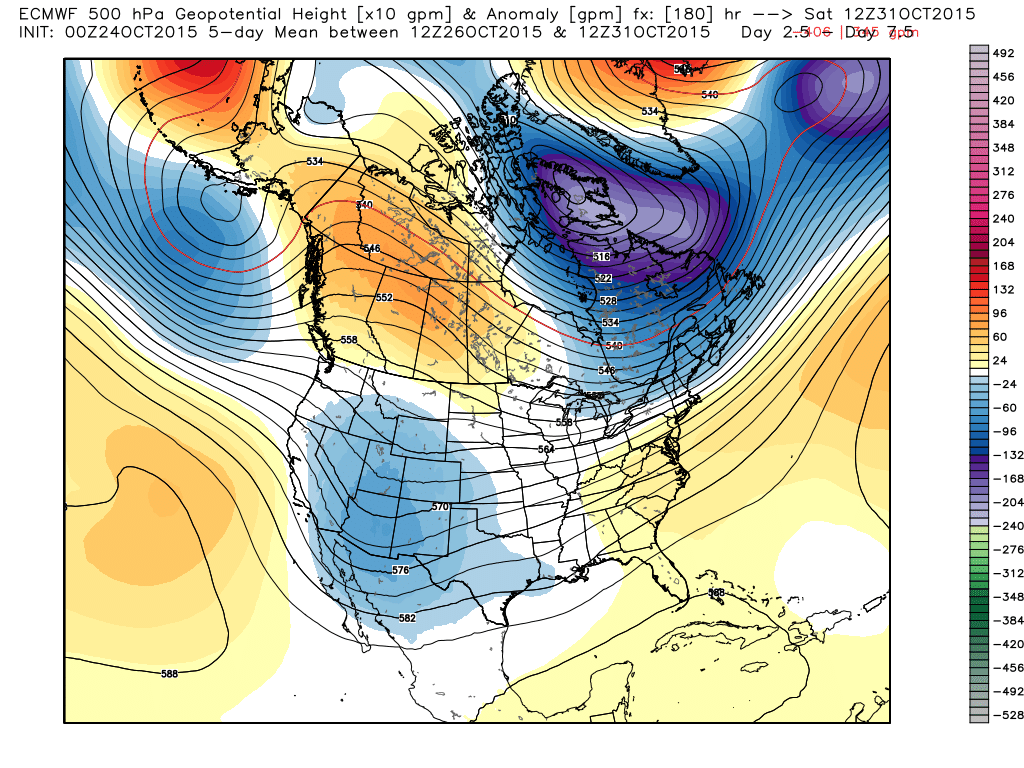
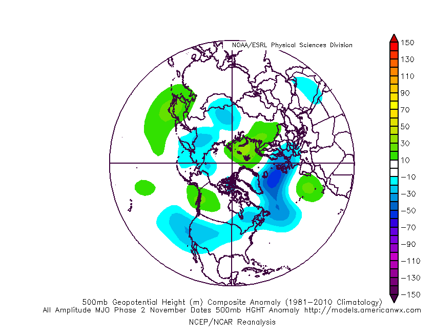
MJO...

H5 composite's of an MJO in phase 2 in November looks pretty similar to what EURO OP is showing.
_________________
_______________________________________________________________________________________________________
CLICK HERE to view NJ Strong Snowstorm Classifications
Frank_Wx- Godzilla Seeker
- Posts : 21305
Reputation : 328
Join date : 2013-01-05
Age : 31
Location : Jersey City, NJ -
Re: Long Range Thread 8.0
![]() by billg315 Sat Oct 24, 2015 11:06 am
by billg315 Sat Oct 24, 2015 11:06 am
http://www.nbcphiladelphia.com/weather/stories/Weather-Winter-Storm-Snow-Philadelphia-Glenn-Hurricane-Schwartz-335870141.html

billg315- Advanced Forecaster - Mod
- Posts : 4468
Reputation : 185
Join date : 2015-01-24
Age : 50
Location : Flemington, NJ
Re: Long Range Thread 8.0
![]() by skinsfan1177 Sat Oct 24, 2015 11:15 am
by skinsfan1177 Sat Oct 24, 2015 11:15 am

skinsfan1177- Senior Enthusiast
- Posts : 4485
Reputation : 35
Join date : 2013-01-07
Age : 46
Location : Point Pleasant Boro
Re: Long Range Thread 8.0
![]() by Frank_Wx Sat Oct 24, 2015 11:19 am
by Frank_Wx Sat Oct 24, 2015 11:19 am
nutleyblizzard wrote:Does it really matter if the peak is delayed as long as the best forcing ends up at the dateline?Frank_Wx wrote:
El Nino watch: Models projecting Nino to remain in "super" status through Nov. Peak likely in December.
I don't think the peak is delayed. Most statistical models have been showing these conditions persisting through November. We have to keep in mind, even if the forcing is over the Dateline that's just going to amp up the STJ even more. That combined with a super El Nino will overwhelm the pattern and we'll run into a situation of seeing above normal temps with a LOT of rain.
Yes, we want the forcing there but preferably when Nino region 3.4 declines under 2.0*C
_________________
_______________________________________________________________________________________________________
CLICK HERE to view NJ Strong Snowstorm Classifications
Frank_Wx- Godzilla Seeker
- Posts : 21305
Reputation : 328
Join date : 2013-01-05
Age : 31
Location : Jersey City, NJ -
Re: Long Range Thread 8.0
![]() by skinsfan1177 Sat Oct 24, 2015 11:25 am
by skinsfan1177 Sat Oct 24, 2015 11:25 am
skinsfan1177- Senior Enthusiast
- Posts : 4485
Reputation : 35
Join date : 2013-01-07
Age : 46
Location : Point Pleasant Boro
Re: Long Range Thread 8.0
![]() by Frank_Wx Sat Oct 24, 2015 11:32 am
by Frank_Wx Sat Oct 24, 2015 11:32 am
skinsfan1177 wrote:So we have a long way to go to get things right for us snow weenies then.
Yes
_________________
_______________________________________________________________________________________________________
CLICK HERE to view NJ Strong Snowstorm Classifications
Frank_Wx- Godzilla Seeker
- Posts : 21305
Reputation : 328
Join date : 2013-01-05
Age : 31
Location : Jersey City, NJ -
Re: Long Range Thread 8.0
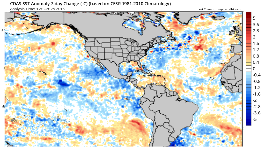
![]() by amugs Sun Oct 25, 2015 12:37 pm
by amugs Sun Oct 25, 2015 12:37 pm


Interesting - as per this chart 1.2 on its way down big tie - great news. 3.4 and 4 up - EPO waters look strong as well. This is going to be very interesting moving forward.
_________________
Mugs
AKA:King: Snow Weenie
Self Proclaimed
WINTER 2014-15 : 55.12" +.02 for 6 coatings (avg. 35")
WINTER 2015-16 Total - 29.8" (Avg 35")
WINTER 2016-17 : 39.5" so far
amugs- Advanced Forecaster - Mod
- Posts : 15093
Reputation : 213
Join date : 2013-01-07
Age : 54
Location : Hillsdale,NJ
Re: Long Range Thread 8.0
![]() by nutleyblizzard Sun Oct 25, 2015 2:32 pm
by nutleyblizzard Sun Oct 25, 2015 2:32 pm
Hey mugs nice graphics. I like how this Nino is shaping up...cooling in eastern areas/warming in the west. The EPO region looks good too. The only fly in the ointment I see as of now if there's a delay in the peak. As long as it occurs by the time December rolls around, we should be in good shape and be looking at the prospects of a great winter.amugs wrote:
Interesting - as per this chart 1.2 on its way down big tie - great news. 3.4 and 4 up - EPO waters look strong as well. This is going to be very interesting moving forward.
nutleyblizzard- Senior Enthusiast
- Posts : 1952
Reputation : 41
Join date : 2014-01-30
Age : 58
Location : Nutley, new jersey
Re: Long Range Thread 8.0
![]() by NjWeatherGuy Sun Oct 25, 2015 5:56 pm
by NjWeatherGuy Sun Oct 25, 2015 5:56 pm

NjWeatherGuy- Advanced Forecaster

- Posts : 4100
Reputation : 28
Join date : 2013-01-06
Location : Belle Mead, NJ
Re: Long Range Thread 8.0
![]() by jmanley32 Sun Oct 25, 2015 7:02 pm
by jmanley32 Sun Oct 25, 2015 7:02 pm

jmanley32- Senior Enthusiast
- Posts : 20516
Reputation : 108
Join date : 2013-12-12
Age : 42
Location : Yonkers, NY
Re: Long Range Thread 8.0
![]() by amugs Sun Oct 25, 2015 7:39 pm
by amugs Sun Oct 25, 2015 7:39 pm

_________________
Mugs
AKA:King: Snow Weenie
Self Proclaimed
WINTER 2014-15 : 55.12" +.02 for 6 coatings (avg. 35")
WINTER 2015-16 Total - 29.8" (Avg 35")
WINTER 2016-17 : 39.5" so far
amugs- Advanced Forecaster - Mod
- Posts : 15093
Reputation : 213
Join date : 2013-01-07
Age : 54
Location : Hillsdale,NJ
Re: Long Range Thread 8.0
![]() by Frank_Wx Sun Oct 25, 2015 9:05 pm
by Frank_Wx Sun Oct 25, 2015 9:05 pm
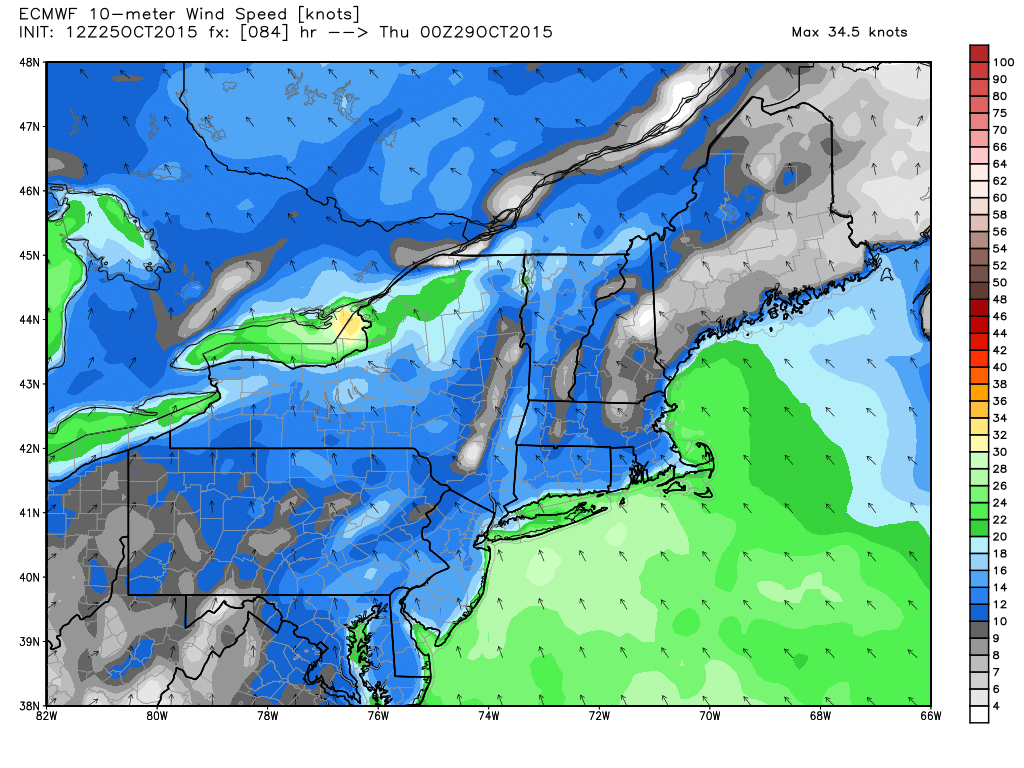
jmanley32 wrote:Frank euro is showing a period of wind advisory or higher level gusts with cutter are u buying this or do u think it will just b rain?
We'll see 20-30mph winds Wednesday afternoon through early Thursday morning
_________________
_______________________________________________________________________________________________________
CLICK HERE to view NJ Strong Snowstorm Classifications
Frank_Wx- Godzilla Seeker
- Posts : 21305
Reputation : 328
Join date : 2013-01-05
Age : 31
Location : Jersey City, NJ -
Re: Long Range Thread 8.0
![]() by Frank_Wx Sun Oct 25, 2015 9:35 pm
by Frank_Wx Sun Oct 25, 2015 9:35 pm
- Attachments

- winter weather outlook.doc Outline of my winter outlookYou don't have permission to download attachments.(28 Kb) Downloaded 35 times
_________________
_______________________________________________________________________________________________________
CLICK HERE to view NJ Strong Snowstorm Classifications
Frank_Wx- Godzilla Seeker
- Posts : 21305
Reputation : 328
Join date : 2013-01-05
Age : 31
Location : Jersey City, NJ -
Re: Long Range Thread 8.0
![]() by amugs Sun Oct 25, 2015 9:59 pm
by amugs Sun Oct 25, 2015 9:59 pm
Kool and the Gang in the PAC - good news overall - man is this getting interesting.
If we go Modoki or some hybrid of BW and Modoki then we could see .............uhmmmmmm, we'll let Frank inform us!
_________________
Mugs
AKA:King: Snow Weenie
Self Proclaimed
WINTER 2014-15 : 55.12" +.02 for 6 coatings (avg. 35")
WINTER 2015-16 Total - 29.8" (Avg 35")
WINTER 2016-17 : 39.5" so far
amugs- Advanced Forecaster - Mod
- Posts : 15093
Reputation : 213
Join date : 2013-01-07
Age : 54
Location : Hillsdale,NJ
Re: Long Range Thread 8.0
![]() by amugs Mon Oct 26, 2015 9:39 am
by amugs Mon Oct 26, 2015 9:39 am

Region 4 baby - got to love it - Dateline forcing - this will help the - EPO south of the Aluetians
_________________
Mugs
AKA:King: Snow Weenie
Self Proclaimed
WINTER 2014-15 : 55.12" +.02 for 6 coatings (avg. 35")
WINTER 2015-16 Total - 29.8" (Avg 35")
WINTER 2016-17 : 39.5" so far
amugs- Advanced Forecaster - Mod
- Posts : 15093
Reputation : 213
Join date : 2013-01-07
Age : 54
Location : Hillsdale,NJ
Re: Long Range Thread 8.0
![]() by nutleyblizzard Mon Oct 26, 2015 10:07 am
by nutleyblizzard Mon Oct 26, 2015 10:07 am
nutleyblizzard- Senior Enthusiast
- Posts : 1952
Reputation : 41
Join date : 2014-01-30
Age : 58
Location : Nutley, new jersey
Re: Long Range Thread 8.0
![]() by Frank_Wx Mon Oct 26, 2015 10:14 am
by Frank_Wx Mon Oct 26, 2015 10:14 am
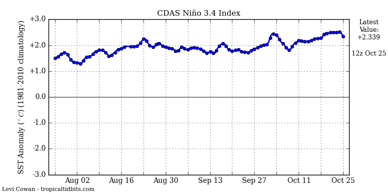
nutleyblizzard wrote:Latest ENSO weeklies are in. Regions 1@2 are at 2.2. Down .03 from last week. Region 3 is holding steady at 2.6. Region 3.4 has climbed to 2.5 which is just below the mark of 2.6 held in 1997. The biggest news though is the latest reading at region 4. It's now standing at 1.3 which ties the all time mark for October 2009!
Wowzers.......

_________________
_______________________________________________________________________________________________________
CLICK HERE to view NJ Strong Snowstorm Classifications
Frank_Wx- Godzilla Seeker
- Posts : 21305
Reputation : 328
Join date : 2013-01-05
Age : 31
Location : Jersey City, NJ -
Re: Long Range Thread 8.0
![]() by nutleyblizzard Mon Oct 26, 2015 10:33 am
by nutleyblizzard Mon Oct 26, 2015 10:33 am
nutleyblizzard- Senior Enthusiast
- Posts : 1952
Reputation : 41
Join date : 2014-01-30
Age : 58
Location : Nutley, new jersey
Re: Long Range Thread 8.0
![]() by amugs Mon Oct 26, 2015 12:29 pm
by amugs Mon Oct 26, 2015 12:29 pm
nutleyblizzard wrote:Just checked the daily ENSO graph for regions 1@2. It continues to cool off rapidly. One can argue that we will have a central based/Modoki event in the coming weeks.
Nuts,
Absolutely, and AWESOME NEWS AT THAT!!!!!!!!!!!!!!!!!
I have the feeling as I wrote about weeks ago on here how the models - now everyone open theior ears and eyes - LAG behind what is actually occurring ESPECIALLY in the ENSO and ARCTIC regions. This lag could be 2-3 weeks BUT nonetheless this is awesome. My gut feeling is we peak in the next month - you watch and we start to head down to moderate stage by mid/late Dec. The problem could be a round of Kelvin Waves or WWBs that could cause a slight spike in SST's but the trade winds usually reverse by this time so they could negate these phenomena. And this from Isotherm:
"The recent significant cooling in region 1+2 is essentially cutting off the proverbial feet of the ENSO event; marginal warming is possible in the central regions. But we're likely going to see the leveling off with peak being attained in November." Don't mess with Therm!!
Now we have the AO and NAO modality to keep an eye on - the indices or charts for this DJFM time frame from the July and winter month relationship points towards a negative AO and NAO starting Dec. With the slug of moisture and the STJ becoming activate (hopefully like Vic Cruz for the Giants) things get really interesting - 1957-58 perhaps or a hybrid of 57-58 and 77-78 - now that would be fricking awesome. Hey, the EPO is going to get help from the trop forcing that is now strongly entrenched out to the dateline - not saying crazy cold like last winter but the area of waters south of Aleutians will IMO give us he -EPO which will help provide a cross polar flow from our neighboring cold war friends in Russia or (Rooosha - roll the R when say IT!).
This from earthlight on the AO and NA0 - very well respected Met and a BIG WOOP WOOP!!
The July AO number, which was -1.108, was the second lowest July AO number on record, only falling behind 2009. While this doesn't seem particularly interesting at first, there seems to be a developing correlation, and a strong one, between that July AO number and the modality of the AO in the following DJF. In fact, 13 of the 15 most negative July AO years had a - AO modality in the following DJF.
Year July AO DJF AO
2009 -1.3 -3.4
2015 -1.1 ? my guess - Math do your magic here kid and give us some stat analysis so we can get a scientific guess at best what we are looking at - I am calling for -1.5
1962 -0.9 -1.9
1968 -0.8 -2.2
1950 -0.8 -0.8
1958 -0.6 -1.3
2000 -0.6 -0.9
1957 -0.6 -0.9
1980 -0.6 -0.1
1960 -0.6 -0.4
1978 -0.6 -1.3
1971 -0.5 0.2
1972 -0.5 -0.4
1993 -0.5 -0.4
1965 -0.5 -1.5
1977 -0.4 -1.2
There is only one year in that dataset that didn't feature a DJF -AO modality after a -AO in July. Additionally, the 2m temperature composite is very cold throughout the Northern 1/3 of the US when considering the DJF's after a -AO July of more than -0.5.
The NAO this July was also the most negative ever (yes, ever). The Top 10 -NAO July composite for the following DJF is so weenie-ish I won't even post it, even when taking out all -QBO years. There is a huge central based blocking signal.
He won't but I will:
J F M A M Ju JULY A S
2015 1.79 1.32 1.45 0.73 0.15 -0.07 -3.18 -0.76 -0.65
_________________
Mugs
AKA:King: Snow Weenie
Self Proclaimed
WINTER 2014-15 : 55.12" +.02 for 6 coatings (avg. 35")
WINTER 2015-16 Total - 29.8" (Avg 35")
WINTER 2016-17 : 39.5" so far
amugs- Advanced Forecaster - Mod
- Posts : 15093
Reputation : 213
Join date : 2013-01-07
Age : 54
Location : Hillsdale,NJ
Page 27 of 40 • 1 ... 15 ... 26, 27, 28 ... 33 ... 40 ![]()
|
|
|