
 Search
Long Range Thread 8.0
Page 28 of 40 •  1 ... 15 ... 27, 28, 29 ... 34 ... 40
 ![]()
Re: Long Range Thread 8.0
![]() by nutleyblizzard Mon Oct 26, 2015 10:33 am
by nutleyblizzard Mon Oct 26, 2015 10:33 am
nutleyblizzard- Senior Enthusiast

- Posts : 1952
Join date : 2014-01-30
Re: Long Range Thread 8.0
![]() by amugs Mon Oct 26, 2015 12:29 pm
by amugs Mon Oct 26, 2015 12:29 pm
nutleyblizzard wrote:Just checked the daily ENSO graph for regions 1@2. It continues to cool off rapidly. One can argue that we will have a central based/Modoki event in the coming weeks.
Nuts,
Absolutely, and AWESOME NEWS AT THAT!!!!!!!!!!!!!!!!!
I have the feeling as I wrote about weeks ago on here how the models - now everyone open theior ears and eyes - LAG behind what is actually occurring ESPECIALLY in the ENSO and ARCTIC regions. This lag could be 2-3 weeks BUT nonetheless this is awesome. My gut feeling is we peak in the next month - you watch and we start to head down to moderate stage by mid/late Dec. The problem could be a round of Kelvin Waves or WWBs that could cause a slight spike in SST's but the trade winds usually reverse by this time so they could negate these phenomena. And this from Isotherm:
"The recent significant cooling in region 1+2 is essentially cutting off the proverbial feet of the ENSO event; marginal warming is possible in the central regions. But we're likely going to see the leveling off with peak being attained in November." Don't mess with Therm!!
Now we have the AO and NAO modality to keep an eye on - the indices or charts for this DJFM time frame from the July and winter month relationship points towards a negative AO and NAO starting Dec. With the slug of moisture and the STJ becoming activate (hopefully like Vic Cruz for the Giants) things get really interesting - 1957-58 perhaps or a hybrid of 57-58 and 77-78 - now that would be fricking awesome. Hey, the EPO is going to get help from the trop forcing that is now strongly entrenched out to the dateline - not saying crazy cold like last winter but the area of waters south of Aleutians will IMO give us he -EPO which will help provide a cross polar flow from our neighboring cold war friends in Russia or (Rooosha - roll the R when say IT!).
This from earthlight on the AO and NA0 - very well respected Met and a BIG WOOP WOOP!!
The July AO number, which was -1.108, was the second lowest July AO number on record, only falling behind 2009. While this doesn't seem particularly interesting at first, there seems to be a developing correlation, and a strong one, between that July AO number and the modality of the AO in the following DJF. In fact, 13 of the 15 most negative July AO years had a - AO modality in the following DJF.
Year July AO DJF AO
2009 -1.3 -3.4
2015 -1.1 ? my guess - Math do your magic here kid and give us some stat analysis so we can get a scientific guess at best what we are looking at - I am calling for -1.5
1962 -0.9 -1.9
1968 -0.8 -2.2
1950 -0.8 -0.8
1958 -0.6 -1.3
2000 -0.6 -0.9
1957 -0.6 -0.9
1980 -0.6 -0.1
1960 -0.6 -0.4
1978 -0.6 -1.3
1971 -0.5 0.2
1972 -0.5 -0.4
1993 -0.5 -0.4
1965 -0.5 -1.5
1977 -0.4 -1.2
There is only one year in that dataset that didn't feature a DJF -AO modality after a -AO in July. Additionally, the 2m temperature composite is very cold throughout the Northern 1/3 of the US when considering the DJF's after a -AO July of more than -0.5.
The NAO this July was also the most negative ever (yes, ever). The Top 10 -NAO July composite for the following DJF is so weenie-ish I won't even post it, even when taking out all -QBO years. There is a huge central based blocking signal.
He won't but I will:
J F M A M Ju JULY A S
2015 1.79 1.32 1.45 0.73 0.15 -0.07 -3.18 -0.76 -0.65
amugs- Advanced Forecaster - Mod

- Posts : 15093
Join date : 2013-01-07
Re: Long Range Thread 8.0
![]() by nutleyblizzard Tue Oct 27, 2015 11:36 am
by nutleyblizzard Tue Oct 27, 2015 11:36 am

nutleyblizzard- Senior Enthusiast
- Posts : 1952
Reputation : 41
Join date : 2014-01-30
Age : 58
Location : Nutley, new jersey
Re: Long Range Thread 8.0
![]() by sroc4 Tue Oct 27, 2015 3:02 pm
by sroc4 Tue Oct 27, 2015 3:02 pm
nutleyblizzard wrote:https://2img.net/h/s10.postimg.cc/5ndnrg021/nino12.png
Regions 1@2 continue to cool rapidly folks. Looking more and more likely for a big time winter to come!!!
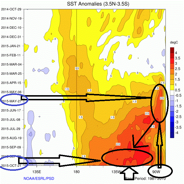
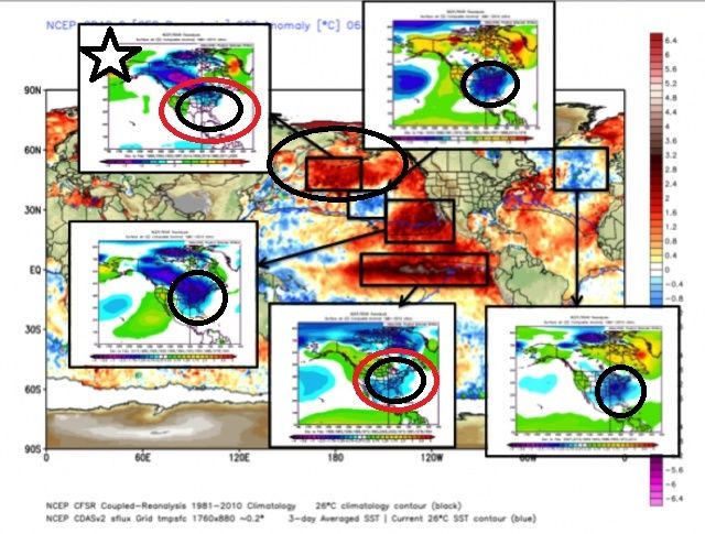
Just remember its the sum of all parts. The following maps are compliments of Joe D'Aleo posted today on Weatherbell: The warmer temp anomalies in the Trop Pac def cont to evolve and shift westward. As you can see by the first image below back in May the warmer temp anomalies were centered around 90W or just off the western S American coast. Throughout the summer and fall you can see they are now centered closer to 120W and the oranges and reds have expanded westward towards 180W. This evolution westward is vital with such a strong El Nino and currently looks great for us in the east as long as the trend continues over the next month or so.
 " />
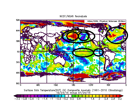
" />However; there are other important SST anomaly regions that continue to evolve. The next map is THE CHANGE in SST anomalies over the last 3 months (July through Oct). As you can see the temp anomalies have been warming between 180(dateline) and 120W in the tropical pac and cooling just off the S American coast reinforcing the image above. The Northern atlantic is warming whereas, the area off the Portugal/Spain coast is cooling. The area that concerns me the most though for winter is the Gulf Of Alaska(GOA) and the area immediately to the west. Notice the GOA has cooled quite a bit over the last 3 months and the area to the west has warmed equally. This focus of warm water shifting west of the GOA may wreak havoc on our EPO signaling IF it were to cont.
 " />
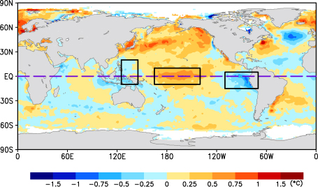
" />The good news is it is still evolving and in fact over the last week the GOA has warmed and the area west has cooled some. The next image is the SST change over the past 1 week only
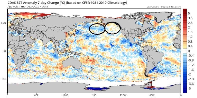 " />
" />The reason the SST anomalies in this region are so important is the temp gradients here aid in establishing the position of a sub Aleutian trough that when positioned south of the Aleutian islands tends to pump an Alaskan ridge (-EPO) which in winter tends to pour arctic air into the Eastern half of the country.
This next image is the SST temp anomalies from last year. Notice the GOA is warm and the anomalies to the immediate west are cool. That area was a key driver in our pattern last year. Without it we do not have the winter we had end of story.
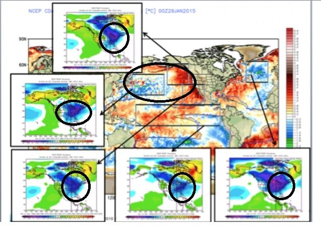 " />
" />You can see, compliments of J D'Aleo, in both Atlantic and Pac the different SST anomaly regions from last year(image above) were favorable for cold in the eastern third of the country including the Northern Pac. The sum of those parts pretty much added up to a cold and snowy east which is exactly what happened. However...this year things are evolving.
 " />
" />As you can see, again compliments of J D'Aleo, the very warm anomalies centered over the central Northern Pac tend to keep the center of the cold into the western Half of Canada and closer to normal temp anaomalies into the eastrn third of the nation which makes sense. If the trough is centered west of the Aleutian islands instead of S then everything down stream shifts west.
But again the SST are still evolving. As you can see by the map above the majority of the ocean temp anomaly regions tend to favor colder anomalies in the eastern CONUS. My point is things are still evolving and even though we have the majority of the SST in our favor or trending in our favor if one area dominates because of extremes then what is expected to happen might not.
Personally I believe that the MJO pulses this winter will play a big role because I believe they will be much stronger due to the intensity of the El Nino. And if the temp anaomalies continue to shift west in the trop Pac the MJO pulses will be in more favorable phases which could enhance the sub Aleutian trough, +PNA ridge out west, and psotion theSTJ more favorably for the EC. There is no doubt this year will be tougher than last year overall.
Last edited by sroc4 on Tue Oct 27, 2015 3:04 pm; edited 1 time in total
_________________
"In weather and in life, there's no winning and losing; there's only winning and learning."
WINTER 2012/2013 TOTALS 43.65"WINTER 2017/2018 TOTALS 62.85" WINTER 2022/2023 TOTALS 4.9"
WINTER 2013/2014 TOTALS 64.85"WINTER 2018/2019 TOTALS 14.25" WINTER 2023/2024 TOTALS 13.1"
WINTER 2014/2015 TOTALS 71.20"WINTER 2019/2020 TOTALS 6.35"
WINTER 2015/2016 TOTALS 35.00"WINTER 2020/2021 TOTALS 37.75"
WINTER 2016/2017 TOTALS 42.25"WINTER 2021/2022 TOTALS 31.65"

sroc4- Admin

- Posts : 8331
Reputation : 301
Join date : 2013-01-07
Location : Wading River, LI
Re: Long Range Thread 8.0
![]() by amugs Tue Oct 27, 2015 3:04 pm
by amugs Tue Oct 27, 2015 3:04 pm
nutleyblizzard wrote:https://2img.net/h/s10.postimg.cc/5ndnrg021/nino12.pngRegions 1@2 continue to cool rapidly folks. Looking more and more likely for a big time winter to come!!!
Basin Wide with a cooling 1.2 - maybe negative by the time Dec rolls in and the warmer waters are doing an exit West - we may not reach Modoki status until Jan sometime which would help the back end if all goes well - remember peeps modoki is when the eastern and western regions are negative or neutral.
Dateline forcing will help the -EPO just S/SW of the Aleutians and pull the positive PNA ridge west and build the trough over the NE. From what I have been reading AO looking good for a 1-2.5 SD Neg for the winter and NAO if we can get the JULY winter correlation effect then we are in great shape.

Here is a Modoki - do we get there??
_________________
Mugs
AKA:King: Snow Weenie
Self Proclaimed
WINTER 2014-15 : 55.12" +.02 for 6 coatings (avg. 35")
WINTER 2015-16 Total - 29.8" (Avg 35")
WINTER 2016-17 : 39.5" so far

amugs- Advanced Forecaster - Mod
- Posts : 15093
Reputation : 213
Join date : 2013-01-07
Age : 54
Location : Hillsdale,NJ
Re: Long Range Thread 8.0
![]() by Frank_Wx Tue Oct 27, 2015 3:09 pm
by Frank_Wx Tue Oct 27, 2015 3:09 pm
MJO going into phase 3, along with +AO/+NAO couplet, means SE Ridge will flex its muscles.


_________________
_______________________________________________________________________________________________________
CLICK HERE to view NJ Strong Snowstorm Classifications

Frank_Wx- Godzilla Seeker
- Posts : 21305
Reputation : 328
Join date : 2013-01-05
Age : 31
Location : Jersey City, NJ -

Re: Long Range Thread 8.0
![]() by sroc4 Tue Oct 27, 2015 3:14 pm
by sroc4 Tue Oct 27, 2015 3:14 pm
amugs wrote:nutleyblizzard wrote:https://2img.net/h/s10.postimg.cc/5ndnrg021/nino12.png
Regions 1@2 continue to cool rapidly folks. Looking more and more likely for a big time winter to come!!!
Basin Wide with a cooling 1.2 - maybe negative by the time Dec rolls in and the warmer waters are doing an exit West - we may not reach Modoki status until Jan sometime which would help the back end if all goes well - remember peeps modoki is when the eastern and western regions are negative or neutral.
Dateline forcing will help the -EPO just S/SW of the Aleutians and pull the positive PNA ridge west and build the trough over the NE. From what I have been reading AO looking good for a 1-2.5 SD Neg for the winter and NAO if we can get the JULY winter correlation effect then we are in great shape.
Here is a Modoki - do we get there??
[img]
 [/img]
_________________
"In weather and in life, there's no winning and losing; there's only winning and learning."
WINTER 2012/2013 TOTALS 43.65"WINTER 2017/2018 TOTALS 62.85" WINTER 2022/2023 TOTALS 4.9"
WINTER 2013/2014 TOTALS 64.85"WINTER 2018/2019 TOTALS 14.25" WINTER 2023/2024 TOTALS 13.1"
WINTER 2014/2015 TOTALS 71.20"WINTER 2019/2020 TOTALS 6.35"
WINTER 2015/2016 TOTALS 35.00"WINTER 2020/2021 TOTALS 37.75"
WINTER 2016/2017 TOTALS 42.25"WINTER 2021/2022 TOTALS 31.65"
sroc4- Admin
- Posts : 8331
Reputation : 301
Join date : 2013-01-07
Location : Wading River, LI
Re: Long Range Thread 8.0
![]() by algae888 Tue Oct 27, 2015 4:03 pm
by algae888 Tue Oct 27, 2015 4:03 pm


1st half of nov looks horrible for any below normal temps. hopefully this pattern will flip heading into dec.

algae888- Advanced Forecaster

- Posts : 5311
Reputation : 46
Join date : 2013-02-05
Age : 61
Location : mt. vernon, new york
Re: Long Range Thread 8.0
![]() by algae888 Tue Oct 27, 2015 4:07 pm
by algae888 Tue Oct 27, 2015 4:07 pm
algae888- Advanced Forecaster
- Posts : 5311
Reputation : 46
Join date : 2013-02-05
Age : 61
Location : mt. vernon, new york
Re: Long Range Thread 8.0
![]() by amugs Tue Oct 27, 2015 4:38 pm
by amugs Tue Oct 27, 2015 4:38 pm
sroc4 wrote:amugs wrote:nutleyblizzard wrote:https://2img.net/h/s10.postimg.cc/5ndnrg021/nino12.png
Regions 1@2 continue to cool rapidly folks. Looking more and more likely for a big time winter to come!!!
Basin Wide with a cooling 1.2 - maybe negative by the time Dec rolls in and the warmer waters are doing an exit West - we may not reach Modoki status until Jan sometime which would help the back end if all goes well - remember peeps modoki is when the eastern and western regions are negative or neutral.
Dateline forcing will help the -EPO just S/SW of the Aleutians and pull the positive PNA ridge west and build the trough over the NE. From what I have been reading AO looking good for a 1-2.5 SD Neg for the winter and NAO if we can get the JULY winter correlation effect then we are in great shape.
Here is a Modoki - do we get there??
No Modoki there - BUT look at the warm trop forcing at the dateline - NICE!!!
_________________
Mugs
AKA:King: Snow Weenie
Self Proclaimed
WINTER 2014-15 : 55.12" +.02 for 6 coatings (avg. 35")
WINTER 2015-16 Total - 29.8" (Avg 35")
WINTER 2016-17 : 39.5" so far
amugs- Advanced Forecaster - Mod
- Posts : 15093
Reputation : 213
Join date : 2013-01-07
Age : 54
Location : Hillsdale,NJ
Re: Long Range Thread 8.0
![]() by amugs Tue Oct 27, 2015 4:43 pm
by amugs Tue Oct 27, 2015 4:43 pm
algae888 wrote:should we be concerned that the AO is going so high positive after it's been mostly neg since july?
I am not concerned - this could change by mid Nov. Typical like Frank said of a Nino fall.
_________________
Mugs
AKA:King: Snow Weenie
Self Proclaimed
WINTER 2014-15 : 55.12" +.02 for 6 coatings (avg. 35")
WINTER 2015-16 Total - 29.8" (Avg 35")
WINTER 2016-17 : 39.5" so far
amugs- Advanced Forecaster - Mod
- Posts : 15093
Reputation : 213
Join date : 2013-01-07
Age : 54
Location : Hillsdale,NJ
Re: Long Range Thread 8.0
![]() by amugs Tue Oct 27, 2015 5:07 pm
by amugs Tue Oct 27, 2015 5:07 pm
Right now there is HUGE Low over eastern Siberia so OCT 2015 may finish strong unlike last year when OCT 2014 fell off at the end
Other years with similar Numbers at week 43 are oct 2010 2006 1995 1970
_________________
Mugs
AKA:King: Snow Weenie
Self Proclaimed
WINTER 2014-15 : 55.12" +.02 for 6 coatings (avg. 35")
WINTER 2015-16 Total - 29.8" (Avg 35")
WINTER 2016-17 : 39.5" so far
amugs- Advanced Forecaster - Mod
- Posts : 15093
Reputation : 213
Join date : 2013-01-07
Age : 54
Location : Hillsdale,NJ
Re: Long Range Thread 8.0
![]() by amugs Tue Oct 27, 2015 5:11 pm
by amugs Tue Oct 27, 2015 5:11 pm
The AO is currently negative and is predicted to trend strongly positive the rest of the week and into early next week and remain positive through mid-November.
The strong turn to positive AO conditions is reflective of the model forecast of low pressure/geopotential heights consolidating over the Arctic while high pressure/geopotential heights dominate the mid-latitudes.
With strong positive AO conditions and low/geopotential heights entrenched across the Arctic, the weather pattern should be relatively mild across the Northern Hemisphere continents including Northern Europe, the Eastern United States and East Asia. Below normal temperatures are likely in regions that experience cool temperatures during positive AO regimes, western North America and southwest Asia.
Longer term we continue to favor a negative bias to the AO. Though not as rapid as the past two Octobers, Siberian snow cover has advanced this month at an above normal rate. Arctic sea ice extent remains below normal especially int eh Barents-Kara seas. We continue to anticipate atmospheric blocking, which favors troposphere-stratosphere coupling due to increased energy transfer from the troposphere to the stratosphere (though the current pattern is admittedly not favorable). All three factors favor a negative winter AO.
_________________
Mugs
AKA:King: Snow Weenie
Self Proclaimed
WINTER 2014-15 : 55.12" +.02 for 6 coatings (avg. 35")
WINTER 2015-16 Total - 29.8" (Avg 35")
WINTER 2016-17 : 39.5" so far
amugs- Advanced Forecaster - Mod
- Posts : 15093
Reputation : 213
Join date : 2013-01-07
Age : 54
Location : Hillsdale,NJ
Re: Long Range Thread 8.0
![]() by HectorO Tue Oct 27, 2015 8:36 pm
by HectorO Tue Oct 27, 2015 8:36 pm
Frank_Wx wrote:It's going to get warm. Most El Nino analogs show warm Novembers so this is not really surprising. IMO, it has no impact to the ensuing winter.
MJO going into phase 3, along with +AO/+NAO couplet, means SE Ridge will flex its muscles.
And then this.... Frank ruins the mood for fall weather...

HectorO- Pro Enthusiast

- Posts : 959
Reputation : 27
Join date : 2013-01-11
Re: Long Range Thread 8.0
![]() by Frank_Wx Tue Oct 27, 2015 9:15 pm
by Frank_Wx Tue Oct 27, 2015 9:15 pm
HectorO wrote:Frank_Wx wrote:It's going to get warm. Most El Nino analogs show warm Novembers so this is not really surprising. IMO, it has no impact to the ensuing winter.
MJO going into phase 3, along with +AO/+NAO couplet, means SE Ridge will flex its muscles.
And then this.... Frank ruins the mood for fall weather..., jk. Is it going to be like the first week or two of October were? I mean obviously not as warm but trend wise?
The main axis of the ridge will be off to our west. If we avoid staying out of the southwesterly flow, we may only get into the upper 60's. It's above normal for this time of year but not too bad considering the magnitude of the ridge and ugly upper level pattern.
_________________
_______________________________________________________________________________________________________
CLICK HERE to view NJ Strong Snowstorm Classifications
Frank_Wx- Godzilla Seeker
- Posts : 21305
Reputation : 328
Join date : 2013-01-05
Age : 31
Location : Jersey City, NJ -
Re: Long Range Thread 8.0
![]() by Frank_Wx Wed Oct 28, 2015 9:44 pm
by Frank_Wx Wed Oct 28, 2015 9:44 pm

Positive heights leading to above normal temps are expected to preside over the eastern U.S. the first 7 to 10 days of November. There are a couple of reasons for this.
1. The AO is making a flip from negative to positive. The negative heights will stay confined to the Arctic Circle and the NAO will continue to stay positive.
2. The trough over the western U.S. may try to cut-off due to the positive heights in the northeast Pacific. This would block the wind flow and prevent this trough from traveling east.
3. MJO is propagating into phase 3. Historically, composites indicate above normal temps for eastern U.S. when the MJO enters this phase.
In general, expect +5 to +10 temp departures from average with temps mainly in the upper 50's to upper 60's across the eastern U.S. (besides southern states where temps may get near 80).
_________________
_______________________________________________________________________________________________________
CLICK HERE to view NJ Strong Snowstorm Classifications
Frank_Wx- Godzilla Seeker
- Posts : 21305
Reputation : 328
Join date : 2013-01-05
Age : 31
Location : Jersey City, NJ -
Re: Long Range Thread 8.0
![]() by sroc4 Thu Oct 29, 2015 8:39 am
by sroc4 Thu Oct 29, 2015 8:39 am
Frank_Wx wrote:
Positive heights leading to above normal temps are expected to preside over the eastern U.S. the first 7 to 10 days of November. There are a couple of reasons for this.
1. The AO is making a flip from negative to positive. The negative heights will stay confined to the Arctic Circle and the NAO will continue to stay positive.
2. The trough over the western U.S. may try to cut-off due to the positive heights in the northeast Pacific. This would block the wind flow and prevent this trough from traveling east.
3. MJO is propagating into phase 3. Historically, composites indicate above normal temps for eastern U.S. when the MJO enters this phase.
In general, expect +5 to +10 temp departures from average with temps mainly in the upper 50's to upper 60's across the eastern U.S. (besides southern states where temps may get near 80).
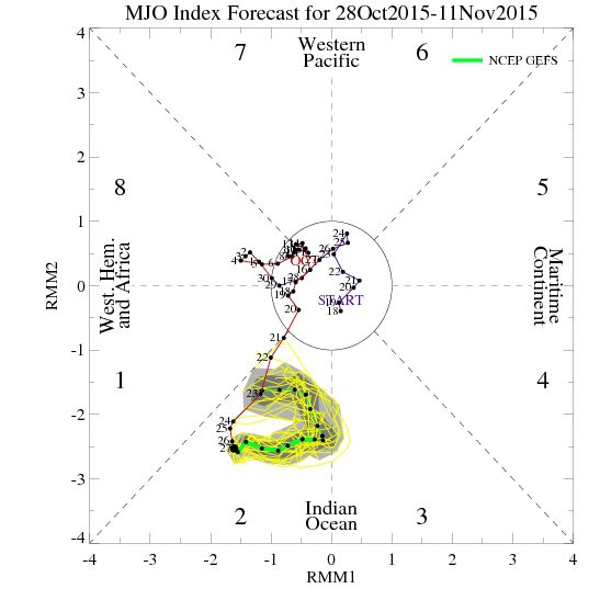
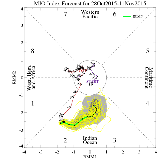
Frank we will have to see if the MJO ever makes it into Phase 3 or not. The MJO forecast did not exactly behave like what was forecast by GEFs and ECMF from two weeks ago. Here is the MJO forecast from October 13th. As per this forecast by both models the MJO was going to propagate through phase 1 before entering phase 2:
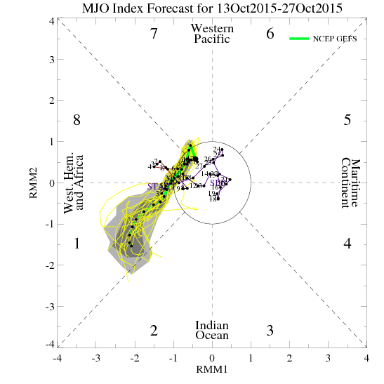 " />
" />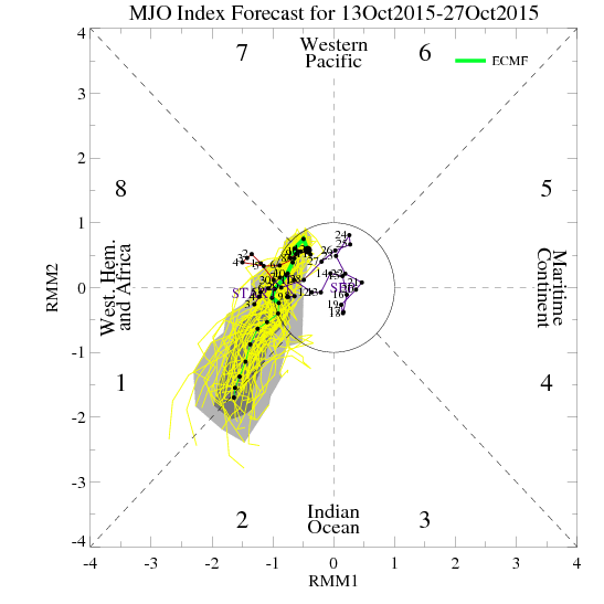 " />
" />However, as can be seen by the current MJO forecast it never actually came out into phase 1 but rather came out and stayed in phase 2. The current GEFS MJO forecast actually looks like it wants to recycle or retrograde in phase 2 back towards phase 1. The ECMF actually is starting to see it towards the end of its forecast period as well. It will be interesting to see how the LR modeling of that strong SE ridging evolves as we get closer relative to the evolution of the MJO forecast.
 " />
" /> " />
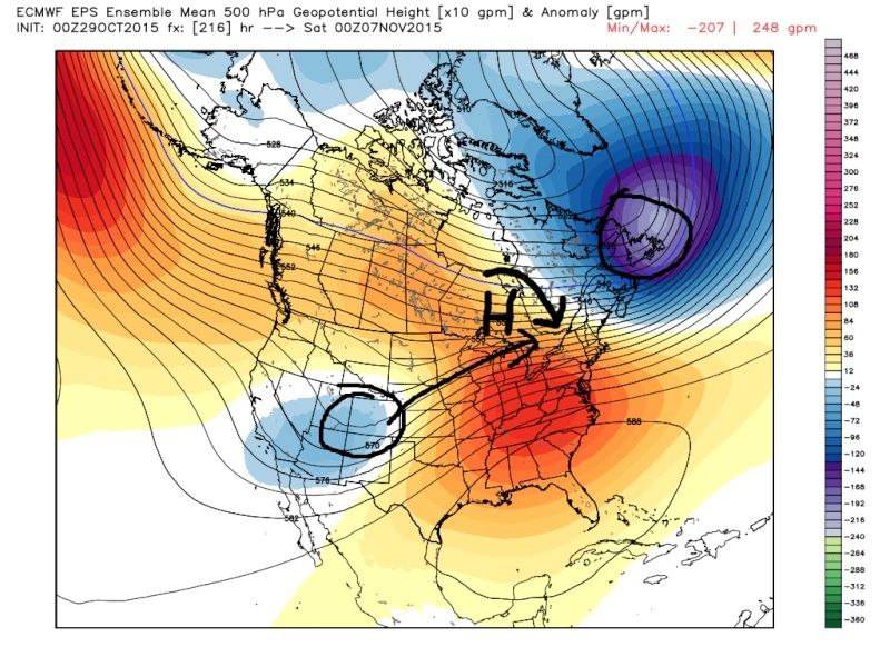
" />JB this morning made some interesting points. He thinks its possible, but not definite, that as we head into the 9-10day and beyond that if the big negative to the NE is stronger and or pulled back a little south and west it may pull a little more of the energy in the SW CONUS out over top of the SE ridge. The result would be a stronger HP in its wake over Canada which would in theory temper the warm up in the NE. Interesting idea. Will have to cont to monitor the LR MJO forecast as historically, composites for Sept/Oct/Nov and Oct/Nov/Dec typically have colder temp anomalies in the east in Phase 2. Composites for Nov/Dec/Jan however do have a more neutral temp anomaly near the coast in phase 2.
 " />
" />_________________
"In weather and in life, there's no winning and losing; there's only winning and learning."
WINTER 2012/2013 TOTALS 43.65"WINTER 2017/2018 TOTALS 62.85" WINTER 2022/2023 TOTALS 4.9"
WINTER 2013/2014 TOTALS 64.85"WINTER 2018/2019 TOTALS 14.25" WINTER 2023/2024 TOTALS 13.1"
WINTER 2014/2015 TOTALS 71.20"WINTER 2019/2020 TOTALS 6.35"
WINTER 2015/2016 TOTALS 35.00"WINTER 2020/2021 TOTALS 37.75"
WINTER 2016/2017 TOTALS 42.25"WINTER 2021/2022 TOTALS 31.65"
sroc4- Admin
- Posts : 8331
Reputation : 301
Join date : 2013-01-07
Location : Wading River, LI
Re: Long Range Thread 8.0
![]() by jmanley32 Thu Oct 29, 2015 12:23 pm
by jmanley32 Thu Oct 29, 2015 12:23 pm

jmanley32- Senior Enthusiast
- Posts : 20513
Reputation : 108
Join date : 2013-12-12
Age : 42
Location : Yonkers, NY
Re: Long Range Thread 8.0
![]() by Frank_Wx Thu Oct 29, 2015 1:51 pm
by Frank_Wx Thu Oct 29, 2015 1:51 pm

_________________
_______________________________________________________________________________________________________
CLICK HERE to view NJ Strong Snowstorm Classifications
Frank_Wx- Godzilla Seeker
- Posts : 21305
Reputation : 328
Join date : 2013-01-05
Age : 31
Location : Jersey City, NJ -
Re: Long Range Thread 8.0
![]() by amugs Thu Oct 29, 2015 2:06 pm
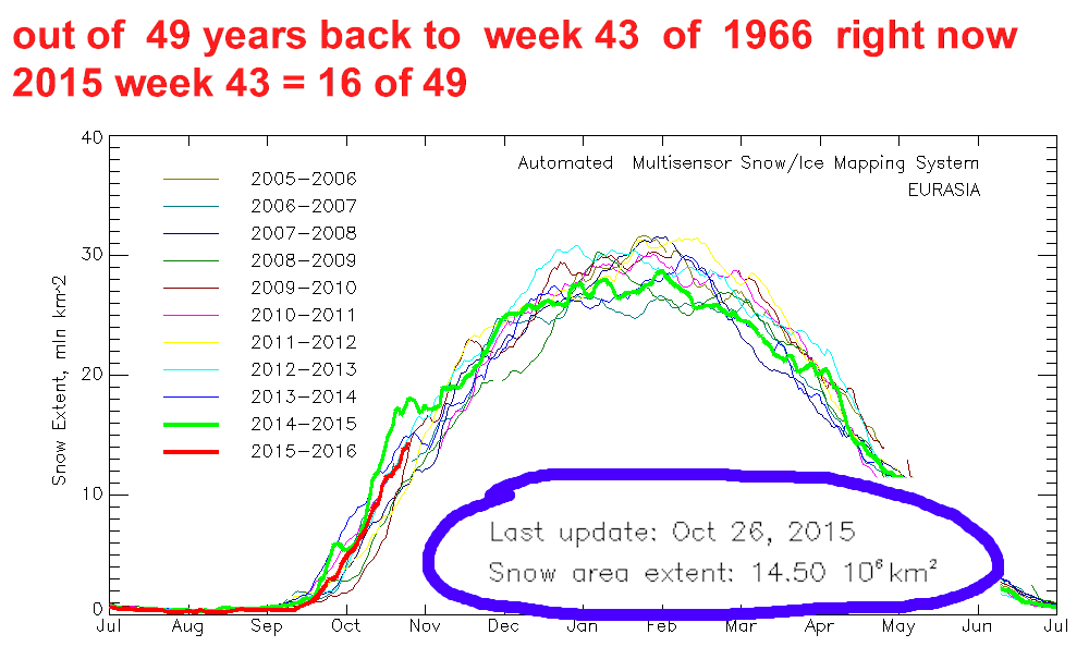
by amugs Thu Oct 29, 2015 2:06 pm
Frank_Wx wrote:Quite remarkable the differences in Eurasian snow cover from last year. 2015 is killing it, and it's only going to get better.
And look at this for numbers :
MADOOONNNNNNNNNNNNNNNEEEEEEE!!
SNOW SIBERIA UPDATE
OCT 25 = 13.61 MILLION sq km oct
OCT 26= 14.50
OCT 27 = 14.90
OCT 28 = 15.16
GAIN OVER over 1.5 million in 4 days KABOOOOOOOOOOOOMMMMM !!!
Remember when I said last week or 10 days ago we go BOOMMMMMM in this region -
_________________
Mugs
AKA:King: Snow Weenie
Self Proclaimed
WINTER 2014-15 : 55.12" +.02 for 6 coatings (avg. 35")
WINTER 2015-16 Total - 29.8" (Avg 35")
WINTER 2016-17 : 39.5" so far
amugs- Advanced Forecaster - Mod
- Posts : 15093
Reputation : 213
Join date : 2013-01-07
Age : 54
Location : Hillsdale,NJ
Re: Long Range Thread 8.0
![]() by sroc4 Thu Oct 29, 2015 2:14 pm
by sroc4 Thu Oct 29, 2015 2:14 pm
Frank_Wx wrote:Quite remarkable the differences in Eurasian snow cover from last year. 2015 is killing it, and it's only going to get better.
Wow. And the ice coverage is quite a bit more as well. Polar bears are quite happy Im sure.
_________________
"In weather and in life, there's no winning and losing; there's only winning and learning."
WINTER 2012/2013 TOTALS 43.65"WINTER 2017/2018 TOTALS 62.85" WINTER 2022/2023 TOTALS 4.9"
WINTER 2013/2014 TOTALS 64.85"WINTER 2018/2019 TOTALS 14.25" WINTER 2023/2024 TOTALS 13.1"
WINTER 2014/2015 TOTALS 71.20"WINTER 2019/2020 TOTALS 6.35"
WINTER 2015/2016 TOTALS 35.00"WINTER 2020/2021 TOTALS 37.75"
WINTER 2016/2017 TOTALS 42.25"WINTER 2021/2022 TOTALS 31.65"
sroc4- Admin
- Posts : 8331
Reputation : 301
Join date : 2013-01-07
Location : Wading River, LI
Re: Long Range Thread 8.0
![]() by algae888 Thu Oct 29, 2015 2:23 pm
by algae888 Thu Oct 29, 2015 2:23 pm
algae888- Advanced Forecaster
- Posts : 5311
Reputation : 46
Join date : 2013-02-05
Age : 61
Location : mt. vernon, new york
Re: Long Range Thread 8.0
![]() by Frank_Wx Thu Oct 29, 2015 3:23 pm
by Frank_Wx Thu Oct 29, 2015 3:23 pm
Here is what it really looked like this time last year:

Here is this year:

_________________
_______________________________________________________________________________________________________
CLICK HERE to view NJ Strong Snowstorm Classifications
Frank_Wx- Godzilla Seeker
- Posts : 21305
Reputation : 328
Join date : 2013-01-05
Age : 31
Location : Jersey City, NJ -
Re: Long Range Thread 8.0
![]() by algae888 Thu Oct 29, 2015 3:33 pm
by algae888 Thu Oct 29, 2015 3:33 pm
algae888- Advanced Forecaster
- Posts : 5311
Reputation : 46
Join date : 2013-02-05
Age : 61
Location : mt. vernon, new york
Re: Long Range Thread 8.0
![]() by Frank_Wx Thu Oct 29, 2015 3:35 pm
by Frank_Wx Thu Oct 29, 2015 3:35 pm
algae888 wrote:Ok. The good thing about the snow cover in Eurasia is that it's not that far off of last year and that is it has occurred in the last half of October which is supposed to have a better influence on the AO this winter.
Correct, and models are predicting continued growth into November.
_________________
_______________________________________________________________________________________________________
CLICK HERE to view NJ Strong Snowstorm Classifications
Frank_Wx- Godzilla Seeker
- Posts : 21305
Reputation : 328
Join date : 2013-01-05
Age : 31
Location : Jersey City, NJ -
Re: Long Range Thread 8.0
![]() by rb924119 Thu Oct 29, 2015 3:54 pm
by rb924119 Thu Oct 29, 2015 3:54 pm
rb924119- Meteorologist

- Posts : 6889
Reputation : 194
Join date : 2013-02-06
Age : 32
Location : Greentown, Pa
Re: Long Range Thread 8.0
![]() by amugs Thu Oct 29, 2015 4:54 pm
by amugs Thu Oct 29, 2015 4:54 pm
rb924119 wrote:Do you guys use the Rutgers Snow Lab graphics at all? They make it so easy to compare instead of trying to do it by eye....
Rb yes and I put the links to both the RU lab and NOAA labs in the weather education thread. NOAA has very nice graphics. And speaking of looky see here:

You want see the snow growth by elapsed time anyone?? Here is teh site
http://www.ncdc.noaa.gov/snow-and-ice/snow-cover/nh/20151002-20151010
@Al, snow growth building through Nov as Frank stated is a key sign to our -AO for the winter, may not be in Dec but the JFM months is when will see this bad boy IMHO.
_________________
Mugs
AKA:King: Snow Weenie
Self Proclaimed
WINTER 2014-15 : 55.12" +.02 for 6 coatings (avg. 35")
WINTER 2015-16 Total - 29.8" (Avg 35")
WINTER 2016-17 : 39.5" so far
amugs- Advanced Forecaster - Mod
- Posts : 15093
Reputation : 213
Join date : 2013-01-07
Age : 54
Location : Hillsdale,NJ
Page 28 of 40 • 1 ... 15 ... 27, 28, 29 ... 34 ... 40 ![]()
|
|
|